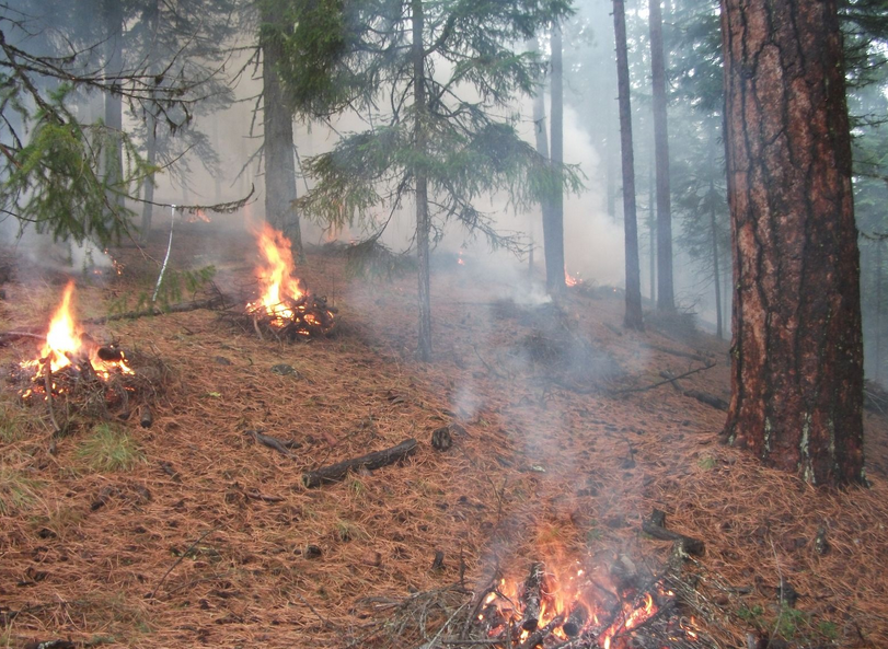
Paul Hart with the Tahoe National Forest sent notice today that the Forest Service will be burning brush piles Tuesday 5/23 along the Hoot (Cable) Trail.
|
Paul Hart with the Tahoe National Forest sent notice today that the Forest Service will be burning brush piles Tuesday 5/23 along the Hoot (Cable) Trail.
 California Trails Conference Foundation is now accepting applications for the Executive Director position for the California Trails Conference Foundation. Resumes are due by June 23rd. View the ED Job Announcement here: https://catrailsconference.org/
For the complete position information, CLICK HERE. 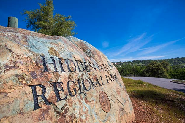 At the request of Placer County parks staff, the board of supervisors today paved the way for a reservation system for county parks and made other ordinance changes for clarity and consistency. Regarding reservations, today’s action authorizes the county’s parks division to establish an automated reservation system to help regulate parking at overcrowded locations such as Hidden Falls Regional Park. Additionally, a new system will streamline the reservation process for other facilities such as sports fields, picnic pavilions and campsites.
“Placer County is looking forward to a new online reservation system set to launch this fall,” said Andy Fisher, parks administrator. “For our visitors who want to reserve a sports field, memorial hall, camp site, or picnic pavilion, the new system will streamline the process, help us manage popular facilities like Hidden Falls Regional Park, and allow greater tracking for security purposes. ” Other changes include making the prohibition on possessing or discharging weapons in any public recreation area managed by the county consistent with other county code sections and the California Penal Code. Another change will exempt service dogs from leash requirements if a leash would interfere with the animal's work or if the owner's disability prevents the use of a leash. Any off-leash service dog still must be under the owner’s control, whether through voice, signal or other methods. Parks staff will return to the board this summer for direction on any needed changes on fees, schedules and fines. Placer County is also in the midst of developing its first-ever master plan for parks and trails. Visit the plan website to learn more, sign up for updates and offer input by taking a survey. Master Plan To see the original article and photos in the Placer County Newsletter, CLICK HERE.  Nevada City, Calif. – The Yuba River Ranger District, part of the Tahoe National Forest, will conduct a series of prescribed fires this spring to reduce build-up of hazardous fuels and continue ecological restoration. Planned projects include low-to-moderate intensity understory burns of forest litter and vegetation on the forest floor.
We plan to implement 200 acres of understory burning in the Camptonville and Pendola areas, as well as 200 acres of understory burning in locations along the Highway 20 corridor in the areas of Harmony Ridge Market, Rock Creek Trail, and Skillman Horse Campground. Careful consideration of fuels and weather conditions will dictate specifically which unit(s) we ignite. The extraordinarily wet winter of 2016-2017 has diminished the spring wildfire threat and has given us a great opportunity to conduct prescribed fire operations with the goals of reducing the severity of future wildfires and providing added protection for communities in the wildland urban interface. In addition, prescribed fire will help to promote a diverse and more resilient forest and improve habitat for wildlife. The Forest Service is also working to reduce fuels by thinning dense stands of trees and brush using mechanical thinning, mastication, and hand removal of vegetation throughout the Forest. Cooler temperatures and ground fuels that are just becoming dry enough to carry low-intensity fire make spring an ideal time to conduct prescribed burning. All prescribed fire projects are conducted in accordance with an approved prescribed fire burn plan. Burn plans describe the specific conditions under which burns will be conducted, including the weather, number of personnel and opportunities to minimize smoke impacts. Smoke from prescribed fire operations is normal and may continue for several days after ignitions. Smoke settles in low lying areas at night and into the morning and usually lifts out during normal daytime warming. All prescribed fires are monitored closely for burning and smoke dispersal conditions and, if necessary, action is taken to mitigate concerns as they arise. Forest Service fuels management personnel work closely with the California Air Resources Board and the local air quality management districts to minimize smoke impacts to communities. Crews also conduct small test burns before igniting a larger area to verify how effectively fuels will be consumed and how smoke will travel.For more information, please contact Jecobie Waters at (530) 288-3231 or jecobiewaters@fs.fed.us. For more information on prescribed fire on the Tahoe National Forest, visit www.fs.usda.gov/tahoe and participate in the conversation at twitter.com/Tahoe_NF and www.facebook.com/TahoeNF. If you would like to learn more about prescribed fire versus wildfire, please visit www.smokeybear.com/prescribed-fires.asp. Even though this is out of our coverage area, many Mother Lode Trails people visit Pt. Reyes National Seashore for the excellent trails there. This is for the equestrians heading that direction - there is a Strangles outbreak at Five Brooks Ranch Rental Stable that operates within Pt. Reyes National Seashore. It is advised to not bring outside horses near that stable, and not to let horses drink out of public troughs until the outbreak clears. Veterinarians estimate 3-4 weeks, if no new cases arise.
 Many reservation fees on Recreation.gov increased, or will be increasing in the next few weeks. These increases are variable depending on the type of reservation and are a result of an increased cost of providing online, call center and field location services. Most of the increases range from .50 cents to $1.00 (added to the current fee of $9.00 to $10.00) and may be reflected when making camping, cabin or day-use reservations on Recreation.gov; in some cases you will see that increase right away, in others, it may take some time for the change to occur. The lottery and permit locations will experience an increase of up to $4.00 or more, which more accurately reflects the cost of implementing these more complex recreation opportunities. The last time we raised our reservation fees was more than 10 years ago.
Enjoy your outdoor adventures! Janelle Smith Recreation.gov | USDA Forest Service From the website: Reservation Fee: If a reservation fee is charged, it is NON-REFUNDABLE. This fee, for some facilities, is $10.00 for call center reservations and $9.00 for web (www.Recreation.gov) reservations. Service Fee: This $10.00 cancellation fee will be deducted from the amount of the refund given to the customer. 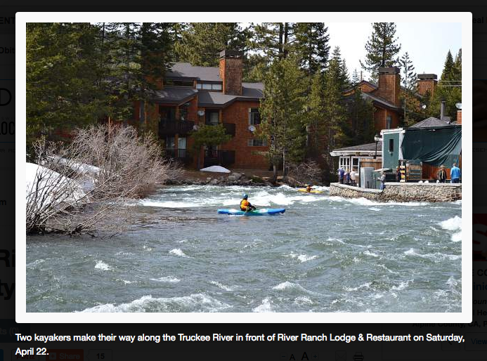 Bicyclists traveling between Tahoe City and Squaw Valley this spring may need to find an alternative route. That's because water traveling out of Lake Tahoe and down the Truckee River has flooded parts of the bike and pedestrian trail along California Route 89.
Residents and visitors rejoiced when Lake Tahoe's snowfall totals hit levels not seen in years, but this summer the impacts of those storms will continue to be seen as the ice melts and the Truckee River continues to rise. "There are ducks swimming down the bike trail," Tahoe City Public Utility District spokesman Kurt Althof said. "There was literally a duck going down the bike trail this morning." The amount of water being spilled from Lake Tahoe was increased April 26 to 2,000 cubic feet per second from 1600. Those figures pale in comparison to the amount of water entering the lake as temperatures warm and snow begins to melt, but the impact downstream is evident. Althof said sections of the bike path are currently submerged in anywhere from 6 to 10 inches of water, and will likely remain that way for some time. "The bike trail is useable, but you certainly can't go from Squaw Valley to Tahoe City," he said. "There are probably 4 or 5 locations where the trail is underwater." Althof said another challenge with maintaining the bike paths this year is that a lot of snow pushed off of the road by snowplows ended up on or near the adjacent bike path. "The Fanny Bridge project is getting underway in a month, so it certainly would have been nice to have that option for pedestrians and bicyclists," he said. The large amount of snowfall the region experienced this year has other impacts on summer recreation as well. To see the complete article and more pictures in the Tahoe Daily Tribune newspaper, CLICK HERE. CLOSED on May 10 for maintenance: Overlook Equestrian and GCTC Equestrian Trail Heads in Tahoe NF5/4/2017
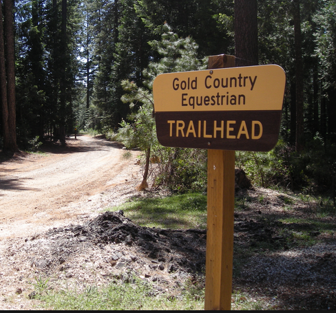 Gold Country Trails Council will be grading and graveling two areas in the Tahoe National Forest, both off Highway 20. The first is the Overlook Equestrian parking area and road on Wednesday, May 10 from 9:00am to noon. The second is to also grade and spread gravel at the Gold Country Trails Council Equestrian Trail Head area, also on May 10, from noon to 4:00pm. DO NOT PARK OR USE THESE AREAS ON MAY 10.
|
Archives
April 2024
Categories |
 RSS Feed