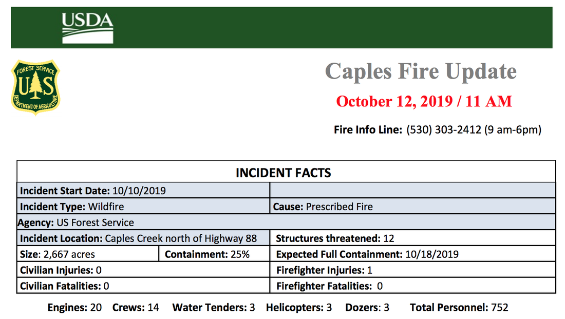
Saturday (12th): Minimal overnight fire activity was observed due to near freezing temperature and light
winds. The fire was mapped with an infrared flight at 2,667 acres and 25% contained (earlier report of 2,100 was from a system error). The Caples Fire is still within the project boundaries. North and west fire lines are being mopped up and patrolled in case of spot fires. Focus is on the south and east lines today. A couple of uphill runs were observed on the south side of the fire last night and there may be an increase in fire behavior if winds pick up today. The southwest division is building hand line directly on the fire’s edge. The southeast division is building direct hand line and scouting for possible dozer line locations. They are tying in the fire line with the natural rock outcroppings in preparation of a tactical firing operation later to remove fuel ahead of the fire’s edge. Helicopters and tanker retardant drops are being strategically used to support line construction.
The prescribed burn project began on September 30 as pile burning under favorable conditions following rain and snowstorms. The prescribed fire was within prescription and achieving the goals of the project of reducing fuels loading and create vegetation conditions that allow fires to burn with lower intensities and create defensible space. Once the red flag warning for the wind event was forecasted fire managers began building fire line and conducting firing operations to secure and strengthen the fire perimeter before the wind arrived. The containment lines held well through the wind event into Thursday morning when the winds changed direction pushing the fire farther to the south and west and increasing the fire activity. This activity increase took the project out of prescription as the project objectives were no longer being met. On October 10, the Caples fire was converted to a wildfire from a prescribed fire allowing managers to obtain additional resources not normally available to us for a prescribed fire, such as; dozers and engines from partners like CALFIRE. The Caples fire is now being managed for full suppression.
Weather Forecast: The natural wind patterns from the west/southwest are good for suppression actions. Temperatures are moderate during the day and the relative humidity is low. Night time temperatures are near freezing with light winds and high relative humidity recovery. Light winds and dry conditions will continue over the weekend. Temperatures will fluctuate a bit but overall remain near normal. Weather conditions are predicted to be continued warm dry conditions with cooler more humid conditions for the second half of next week.
Smoke: Smoke sensitive individuals are encouraged to reduce their exposure by avoiding smoky areas, closing windows, or staying indoors. Smoke settles in the valleys and canyons at night but usually clears later in the morning with the natural diurnal upcanyon winds.
Evacuations: None
Road Closures: Due to the active fire operations in progress, hiking and hunting in the Silver Fork/ Caples Creek area is not recommended. Roads are blocked at the following intersection: Packsaddle Pass and Silver Fork Road; Packsaddle Pass and 11N19; Mormon Emigrant Trail and Silver Fork Road; Martin Meadows, Margaret and Shealor Lake Trailheads, and Schneider Camp. If you see a road blocked for fire activity please comply to keep firefighters and the public safe.
Caples Ecological Restoration Project: The Caples Ecological Restoration Project is restoring fire to the Caples Creek watershed where naturally occurring wildfires started by lighting have been suppressed since 1908. The project is intended to improve forest health, fire resiliency and increase public safety. Prescribed fire treatments reduce fuel loadings, maintain vegetation conditions that allow fires to burn with lower intensities and create defensible space. The goal of this project is to promote a healthy resilient forest by reintroducing fire to the landscape.
The Caples Ecological Restoration Project is a collaborative effort between the Eldorado National Forest, El Dorado Irrigation District and Sierra Nevada Conservancy to restore fire to the Caples Creek watershed where naturally occurring wildfires started by lighting have been suppressed since 1908. The project provides a strategic landscape-wide fuel treatment that will reduce fuel to pre-settlement conditions that will protect the chief water supply to El Dorado County, improve wildlife habitat and create defensible space to nearby communities. The Caples Creek watershed provides a primary water supply for 110,000 people in the El Dorado Irrigation District (EID) service area and includes some of the last remaining old growth in the Eldorado National Forest.
Inciweb: https://inciweb.nwcg.gov/incident/6522/
Twitter: @EldoradoNF
Gmail: EldoradoIncidents@gmail.com
Facebook: Facebook.com/EldoradoNF/
CLICK HERE to see USDA Press Release.

 RSS Feed