SEPT. 18 UPDATE
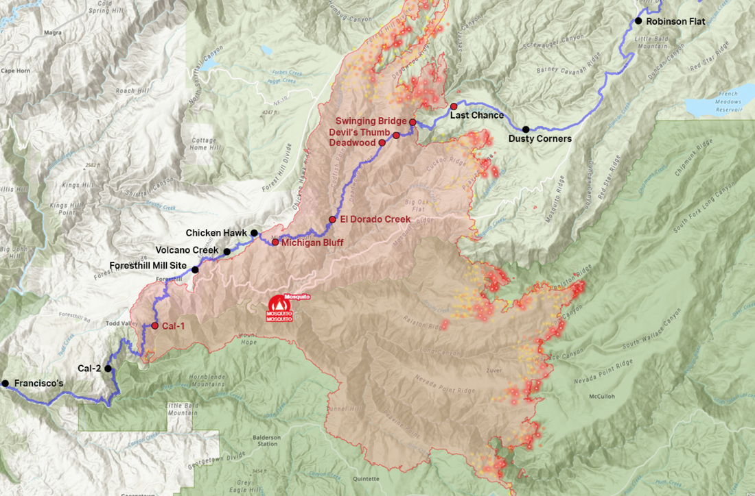
As many of you know, the middle section of the 100-mile WS Trail, including the canyons and
Cal-1/Dardenelles west of Foresthill, was burned by the Mosquito Fire. As of writing, this fire continues to burn along the eastern perimeter, measured at nearly 75,000 acres and 34% contained. There are more than 3,700 personnel assigned to the fire and dedicated to getting it contained by mid-October.
As a result of the damage sustained from the devastating fire, the Foresthill USFS District lands are closed to the public until January 1, 2023. This district manages the lands from the top of Palisades Ski resort (formerly Squaw Valley) to the western border of the town of Foresthill. This section of forest includes approximately 60 miles of the WS Trail.
Prior the fire, the WSTF had been meeting with the Foresthill Ranger District, Tahoe National Forest office of USFS regarding the trail maintenance and improvements that we started before this year’s 2022 Tevis event.
As the Tahoe National Forest District lands open up, WSTF—and its sister event the Western States Endurance Run—will access all available funds to work with the USFS to recondition the fire-affected trail. There should be opportunities for additional funding to restore areas hardest hit during the Mosquito Fire. We hope to be able to combine forest restoration funding with WSTF monies to resume the work we began this summer.
The timeline of this work is not yet known until the Mosquito Fire is contained. WSTF crews hope to get to work this winter on some of the lower sections of the trail after the district opens back up in January.
This is huge and dangerous fire affected many entities, property, people and the animals they love dearly. The west end of Michigan Bluff was particularly hard-hit. Thankfully evacuations are gradually being lifted as areas are deemed safe.
All of us who love this historic Ride have a huge task ahead of us to restore this trail. We will be stronger together on the other side of this devastating event, however long that takes.
If you would like to help with the Western States Trail Reconditioning Project, please click here to find out how.
================================
POSTED SEPT. 12, 2022:
From the Tevis Trail Facebook page Sept. 12, 2022:
WST - yellow highlight
KS - Kaput Spring
DW - Deadwood vet check
DT - Devil's Thumb aid area
SB - Swinging Bridge
LC - Last Chance vet check
Mosquito Fire - Monday Sept 12th - 1 pm - 46,587, 10% contained
Impacts to the WST:
* The fire has burned over approximately 12 miles of the WST between Devil's Thumb and Chicken Hawk vet check.
The fire is still making its way northwards in El Dorado Canyon, and fire fighters are continuing to put in indirect containment lines on the north end of Deadwood Ridge to the west to try and tie the fire back over to Foresthill Rd.
* Fire fighters have been up at Robinson Flat, moving down Rd 43, and over towards Last Chance.
They have put in a dozer line along the WST from Rd 43 all the way to where the trail drops into the canyon at Pacific Slab Mine after leaving Last Chance. This is partially the old dozer line from when that area burned during the American Fire in 2013. They were in contact with ranchers to get the cows moved out of that area.
There was a recent scanner report of road damage to Rd 43 (the dirt road the Ride uses after leaving Robinson Flat) from heavy equipment passing over it, and they were going to mitigate that issue.
WST - yellow highlight
KS - Kaput Spring
DW - Deadwood vet check
DT - Devil's Thumb aid area
SB - Swinging Bridge
LC - Last Chance vet check
https://www.facebook.com/TevisCup/photos/a.180835061940668/5718590744831711/
 RSS Feed