California's banner Sierra Nevada snowfall plus a record number of hikers have kept local search and rescue teams very, very busy.
The Pacific Crest Trail doles out hazards in cruel ways. Thousands of hikers on the 2,650-mile trek face perils including rattlesnakes, exposure, corneal flash burns from snow glare, and heatstroke. But 2017 is shaping up to be one of the most frightening years in the national scenic trail’s history, thanks to the massive snowpack in the Sierra Nevada combined with the trail’s unprecedented popularity.
Just a couple of months into hiking season, thru-hikers are posting stories of near-death experiences.
Jack Haskel, spokesman for the Pacific Crest Trail Association, is fielding calls and hearing stories “every week, if not every day” involving avalanches, falls on slippery slopes, exposure, and dunkings in chin-high creeks. “There was a pretty serious incident in which a hiker fell and punctured a lung,” he says.
Sequoia and Kings Canyon national park staffers contacted Haskel about several recent medical evacuations by helicopter. One involved a hiker who fell near Forester Pass, the trail’s highest point, at 13,153 feet. In early June, Haskel issued a bluntly worded message on a 16,000-member Facebook page for PCT hikers. “I’m worried that someone will die,” he wrote. “It’s no joke…Do you have the fitness and skills to do this type of stuff safely?”
PCT thru-hikers usually begin from the southern terminus in Campo, California, near the Mexican border in late April or early May. This means that the first hikers have already breached the southern end of the Sierra Nevada, where winter snowfall, in certain high elevation spots, reached record highs: the overall snowpack in the Sierra is the deepest since 2011, according to California’s Department of Water Resources. California desperately needed that precipitation after an historic drought, but the same conditions have brought out the nasty and unpredictable side of the PCT.
Record snowpack was reported at Sonora Pass, lower Carson Pass, and other high-elevation spots on or close to the PCT, according to Jeff Anderson, staff hydrologist for the snow survey department of the Natural Resources Conservation Service in Reno, Nevada. In June, Anderson and his team measured 180 inches of snow at Leavitt Lake at 9,600 feet, just east of the Sierra crest. “Given this rate, it is likely that this area will not be snow-free for fifty to a hundred more days,” he says.
In late May, thru-hiker and experienced mountaineer Brien Bower, a 25-year-old volcano climbing guide from Seattle, was walking near snowbound Glen Pass when he started checking for avalanche conditions. Suddenly, a large shelf of snow gave way and started sliding down, with Bower still standing on it.
“Looking up, I could see the rocks on the other side of the valley were quickly moving by,” Bower recalled. “I knew I was in an avalanche. All I could do was try to stay upright and in control.” Bower slid 400 feet down the slope and fell down a 20-foot vertical drop. “I’m lucky it wasn’t 200 feet,” he said. Bower escaped without broken bones, though he was treated for dehydration and sunburn at a hospital in Fresno, but the near misses are piling up.
Near the end of May, an Australian hiker whose trail name is “Thor” got swept away while attempting to ford Bear Creek near Selden Pass in the High Sierra. He tumbled and rolled in the water before swimming to shore, according to a video post uploaded by hiker Daniel Winsor on his “Professional Vagrant” page.
About a thousand miles into his hike, long-distance hiker Marcus Mazzaferri fell on a loose rock in a Yosemite creek, was swept into the current, and lost his pack in the water. “He was out by himself with no equipment and spent a night out,” Haskel says. “He was following his footprints back to the nearest road. It is a deeply concerning story.” In an account on Facebook, Mazzaferri described “sub-freezing temps” and doing jumping jacks and running around in circles to keep from freezing. Understandably, he bailed out of the trail after making his way to safety. “I am truly lucky and grateful to be alive,” he wrote.
It might not be such a problem if there weren't so many people on the trail. In the early 1990s, only 30 or so people completed the route every year. Compare that to last year, when the Pacific Crest Trail Association issued long-distance permits to 3,164 northbound long-distance hikers. (About 700 finished the trail.) The PCTA will not release the number of current thru-hikers until the end of this year, “but I would say the numbers are pretty similar to last year,” Haskel says.
Some thru-hikers have attempted a “flip-flop” approach, which means breaking up the trail into strategic chunks rather than sticking to a continuous hike. Flip-flopping was no option for Brandon Toftner, a 28-year-old electrician from Columbus, Ohio, who vowed to take on a south-north through-hike no matter what. In late May, he was making his slow way up a steep ridge near Cottonwood Pass. Crampons didn’t help. One little slip sent him sliding 100 feet down a steep slope. Toftner self-arrested with his ice axe, a mere 10 feet away from the trees. “It scared me,” he said. “I would have been dead or have about a thousand broken bones.”
After getting off the trail at Kearsarge Pass above Lone Pine, Toftner decided to take a brief respite, but vowed to return soon. He said his experience in the United States Marine Corps from 2008 to 2012, with two deployments to Afghanistan, made him ready for anything the PCT might dish out. “It was all about completing a mission no matter what,” he explained.
But Toftner changed his mind. In the end, he bailed out and booked a trip to a place that he thought would give him far less trouble than the PCT—the grizzly-populated wilderness of Denali National Park.
Article by By: Dan White
Jun 16, 2017
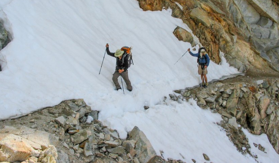
PHOTO: Crossing a snow patch below Forester Pass. Photo: Junaid Dawud/Flickr
To see the original article in the Outside Magazine Online, CLICK HERE.
The Pacific Crest Trail doles out hazards in cruel ways. Thousands of hikers on the 2,650-mile trek face perils including rattlesnakes, exposure, corneal flash burns from snow glare, and heatstroke. But 2017 is shaping up to be one of the most frightening years in the national scenic trail’s history, thanks to the massive snowpack in the Sierra Nevada combined with the trail’s unprecedented popularity.
Just a couple of months into hiking season, thru-hikers are posting stories of near-death experiences.
Jack Haskel, spokesman for the Pacific Crest Trail Association, is fielding calls and hearing stories “every week, if not every day” involving avalanches, falls on slippery slopes, exposure, and dunkings in chin-high creeks. “There was a pretty serious incident in which a hiker fell and punctured a lung,” he says.
Sequoia and Kings Canyon national park staffers contacted Haskel about several recent medical evacuations by helicopter. One involved a hiker who fell near Forester Pass, the trail’s highest point, at 13,153 feet. In early June, Haskel issued a bluntly worded message on a 16,000-member Facebook page for PCT hikers. “I’m worried that someone will die,” he wrote. “It’s no joke…Do you have the fitness and skills to do this type of stuff safely?”
PCT thru-hikers usually begin from the southern terminus in Campo, California, near the Mexican border in late April or early May. This means that the first hikers have already breached the southern end of the Sierra Nevada, where winter snowfall, in certain high elevation spots, reached record highs: the overall snowpack in the Sierra is the deepest since 2011, according to California’s Department of Water Resources. California desperately needed that precipitation after an historic drought, but the same conditions have brought out the nasty and unpredictable side of the PCT.
Record snowpack was reported at Sonora Pass, lower Carson Pass, and other high-elevation spots on or close to the PCT, according to Jeff Anderson, staff hydrologist for the snow survey department of the Natural Resources Conservation Service in Reno, Nevada. In June, Anderson and his team measured 180 inches of snow at Leavitt Lake at 9,600 feet, just east of the Sierra crest. “Given this rate, it is likely that this area will not be snow-free for fifty to a hundred more days,” he says.
In late May, thru-hiker and experienced mountaineer Brien Bower, a 25-year-old volcano climbing guide from Seattle, was walking near snowbound Glen Pass when he started checking for avalanche conditions. Suddenly, a large shelf of snow gave way and started sliding down, with Bower still standing on it.
“Looking up, I could see the rocks on the other side of the valley were quickly moving by,” Bower recalled. “I knew I was in an avalanche. All I could do was try to stay upright and in control.” Bower slid 400 feet down the slope and fell down a 20-foot vertical drop. “I’m lucky it wasn’t 200 feet,” he said. Bower escaped without broken bones, though he was treated for dehydration and sunburn at a hospital in Fresno, but the near misses are piling up.
Near the end of May, an Australian hiker whose trail name is “Thor” got swept away while attempting to ford Bear Creek near Selden Pass in the High Sierra. He tumbled and rolled in the water before swimming to shore, according to a video post uploaded by hiker Daniel Winsor on his “Professional Vagrant” page.
About a thousand miles into his hike, long-distance hiker Marcus Mazzaferri fell on a loose rock in a Yosemite creek, was swept into the current, and lost his pack in the water. “He was out by himself with no equipment and spent a night out,” Haskel says. “He was following his footprints back to the nearest road. It is a deeply concerning story.” In an account on Facebook, Mazzaferri described “sub-freezing temps” and doing jumping jacks and running around in circles to keep from freezing. Understandably, he bailed out of the trail after making his way to safety. “I am truly lucky and grateful to be alive,” he wrote.
It might not be such a problem if there weren't so many people on the trail. In the early 1990s, only 30 or so people completed the route every year. Compare that to last year, when the Pacific Crest Trail Association issued long-distance permits to 3,164 northbound long-distance hikers. (About 700 finished the trail.) The PCTA will not release the number of current thru-hikers until the end of this year, “but I would say the numbers are pretty similar to last year,” Haskel says.
Some thru-hikers have attempted a “flip-flop” approach, which means breaking up the trail into strategic chunks rather than sticking to a continuous hike. Flip-flopping was no option for Brandon Toftner, a 28-year-old electrician from Columbus, Ohio, who vowed to take on a south-north through-hike no matter what. In late May, he was making his slow way up a steep ridge near Cottonwood Pass. Crampons didn’t help. One little slip sent him sliding 100 feet down a steep slope. Toftner self-arrested with his ice axe, a mere 10 feet away from the trees. “It scared me,” he said. “I would have been dead or have about a thousand broken bones.”
After getting off the trail at Kearsarge Pass above Lone Pine, Toftner decided to take a brief respite, but vowed to return soon. He said his experience in the United States Marine Corps from 2008 to 2012, with two deployments to Afghanistan, made him ready for anything the PCT might dish out. “It was all about completing a mission no matter what,” he explained.
But Toftner changed his mind. In the end, he bailed out and booked a trip to a place that he thought would give him far less trouble than the PCT—the grizzly-populated wilderness of Denali National Park.
Article by By: Dan White
Jun 16, 2017
PHOTO: Crossing a snow patch below Forester Pass. Photo: Junaid Dawud/Flickr
To see the original article in the Outside Magazine Online, CLICK HERE.
 RSS Feed