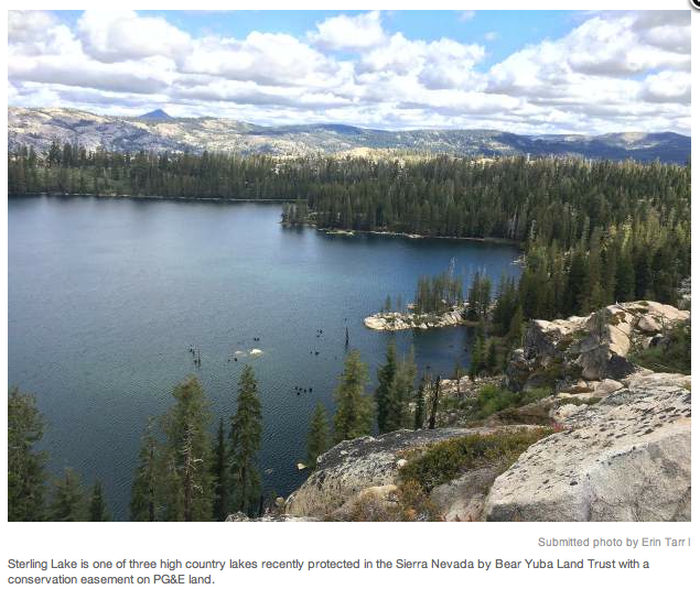
At 7,000 feet elevation in the high Sierra Nevada, three alpine lakes and 2,000 remote acres of forest and granite landscapes important to outdoor recreationists are now permanently protected by Bear Yuba Land Trust on land owned by Pacific Gas and Electric Company..
This month, Fordyce, Meadow and Sterling lakes became protected in conservation easements by BYLT, a community-supported conservation group with a 26-year foothold in the Bear and Yuba watersheds of Northern California.
The conservation deal was stipulated as part of PG&E’s bankruptcy settlement in 2003 when the utility company — one of the state’s biggest private landowners — agreed to permanently protect the beneficial public values on the watershed lands associated with its hydroelectric generation facilities.
“BYLT’s protection of these high elevation reservoirs is a huge victory for the Sierra Nevada,” said BYLT Director of Land Stewardship Erin Tarr. “The lands we are protecting encompass important reservoirs in the Sierra Nevada headwaters region. When BYLT conserves a property it is in perpetuity. When we think about conservation of critical landscapes we are thinking of current issues as well as potential impacts for centuries to come.”
PG&E impounds the water in Fordyce, Meadow and Sterling reservoirs for hydroelectric operations via a complex network of canals and creeks downstream at Lake Spaulding.
PROTECTING WATER SUPPLY, SENSITIVE SPECIES
More than 60 percent of California’s developed water supply originates in the Sierra Nevada providing all or part of the drinking and agricultural water for 23 million people, according to Sierra Nevada Conservancy. Land stewardship within the watershed is crucial to preserving a reliable water supply and improving water quality.
In 2004, as part of PG&E’s bankruptcy settlement, Pacific Forest and Watershed Lands Stewardship Council was established to work with land trusts to ensure 140,000 acres of California’s pristine PG&E watershed lands in the Sierra Nevada, Cascades and North Coast Range are conserved for the public good.
The newly conserved acreage around the three reservoirs in Nevada County supports habitat for a diverse range of wildlife including special status species such as: American martin, Pacific fisher, mountain yellow-legged frog, and the elusive California wolverine, last spotted near Truckee.
“Climate change impacts have the potential to change the way our water is captured and transported,” said Erin Tarr. “Now that BYLT has permanent conservation easements on these lands we will ensure the biological and recreational values are protected forever. Even if a change of ownership occurs, development will not be possible on these lands.”
“PG&E is pleased to grant this conservation easement to BYLT,” said PG&E Director of Strategic Agreements Mike Schonherr. “We’ve all worked very hard to bring this to fruition and PG&E is excited to work in partnership with BYLT to ensure these amazing resources will be available for enjoyment by future generations of Californians.”
CHECKERBOARD OWNERSHIP
BYLT’s conservation easements border one of Tahoe National Forest’s most popular outdoor meccas, Grouse Ridge Non-Motorized Area. Nearby the Pacific Crest Trail and mountain resorts on Donner Summit draw hordes of weekend outdoor adventurers from the Bay Area along busy Interstate 80.
“Rock crawling” OHV clubs have popularized the area and Friends of Fordyce keep a caretaker presence. Year-round public recreation is permitted such as camping, fishing and back country skiing. Fordyce Lake is the largest of the three lakes but more challenging to access than Meadow Lake. Boy Scouts lease a camp at Sterling Lake.
The land is considered vulnerable by the land trust because of its location within the “Sierra Nevada Checkerboard,” a mosaic spanning several thousand acres of public and private ownership shared with Tahoe National Forest, Nevada Irrigation District, Sierra Pacific Industries, and private interests dating back to the construction of the transcontinental railroad in the 1860s.
As an early day incentive, the federal government offered railroad companies “every other square mile” of land in the Sierra Nevada, reserving the intervening sections to become National Forest.
“The result has been a lack of consistency in land management and land use patterns. This has caused fragmentation of the landscape that degrades the integrity of the watershed for healthy forests and wildlife habitat,” said BYLT’s Executive Director Marty Coleman-Hunt.
“Worse yet, if left unprotected, these private parcels of forestland may be converted to rural sprawl — second home mansions and commercial resorts — over the next 10 to 20 years. We are seeing real estate acquisitions like these already in our mountains. Land trusts offer landowners who care about conservation an alternative to selling the land to the highest development bidder.”
In a nutshell, a conservation easement is a voluntary, legally binding agreement that prevents a willing landowner and its successors from developing or subdividing a property and to protect its natural resources and biodiversity in perpetuity. In essence, development rights are forfeited and no longer exist.
A BIT OF HISTORY
Meadow Lake includes the former site of Summit City, a town of 4,000 during the Gold Rush. In the early 1850s, stage stations in the region provided fresh food for travelers across the Sierra Nevada to the gold fields. Besides boarding horses, mules and cattle, Jerome Fordyce and his partners built a large number of distribution reservoirs and canals, and dammed 20 small lakes to increase their capacities.
Fordyce dam was begun in 1873 as the main storage reservoir for the South Yuba Canal Company. By 1882, the dam reached 96 feet, the largest dam in California at that time. About 18 electric companies emerged along the reservoirs, which were ultimately absorbed by PG&E by the 1920s.
With the addition of this mountain landscape, BYLT’s portfolio of conserved land has grown to nearly 11,000 acres in the Bear River and Yuba River watersheds of the state’s renowned Gold Rush country.
BYLT’s newest conservation easements are the third and fourth PG&E projects to close in recent years, following two lower Yuba River properties in 2015: PG&E Narrows in Nevada County and UC Narrows in Yuba County.
Eight more planning units are scheduled to move into permanent protection by 2018, for an additional 10,000 acres. They include: Lindsay Lakes and Grouse Ridge lands, Lake Spaulding, Deer Creek headwaters, Bear Valley and 17 miles of the Bear River between the headwaters and Rollins Lake.
To see the original article and photos in The Union newspaper, CLICK HERE
 RSS Feed