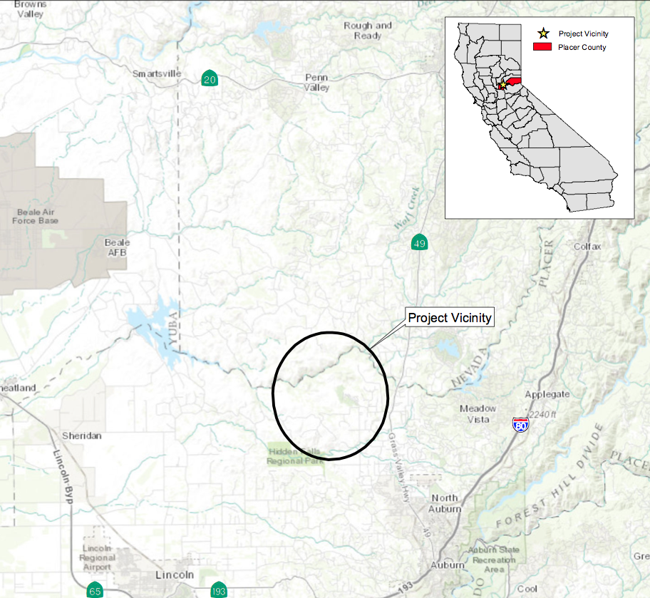
The proposed trail expansion area is located northeast of the existing Hidden Falls Regional Park, and south of the Bear River in Placer County, approximately 40 miles northeast of Sacramento (see Figure 1 of the NOP, Regional Location Map, above).
The Final EIR has been prepared. (see below)
The Final EIR has been prepared. (see below)
(Figure 2 - Project Vicinity Map above)
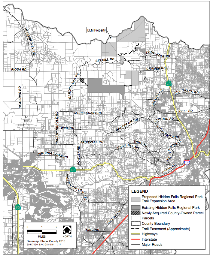
Hidden Falls Regional Park encompasses approximately 1,200 acres in the Sierra Nevada foothills, consisting of the properties formerly known as the Spears Ranch and Didion Ranch. The existing park has two access points, with a parking area at Mears Place and an area for a future parking lot off of Garden Bar Road. Figure 2 of the NOP shows the project area including regional highways (e.g., State Route 49) and local roads including Big Hill Road through the center of the project area; Mt. Pleasant Road to the south; Bell Road, Cramer Road, and Lone Star Road providing access from State Route 49; and Garden Bar Road to the west.
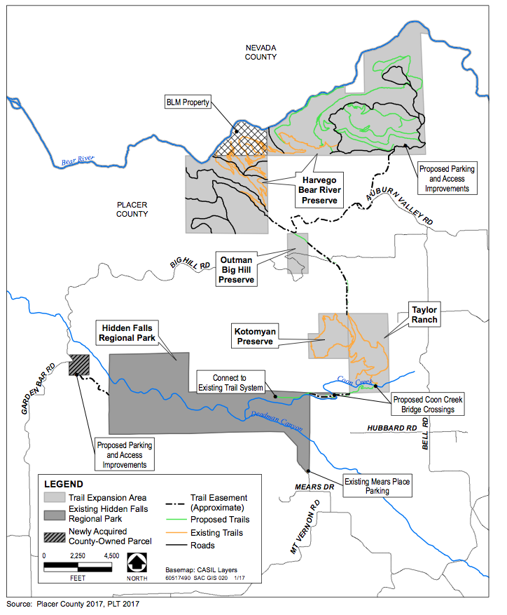
Most of the proposed trail expansion areas are located north and northeast of the existing park and consist of the areas known as Taylor Ranch (321 acres) and Harvego Bear River Preserve (1,773 acres), and of privately-owned parcels with trail easements, such as Liberty Ranch (313 acres). Trails will also cross the Kotomyan Preserve (160 acres) and Outman Big Hill Preserve (80 acres). Additionally, trail connections are proposed from a recently-acquired parcel off of Garden Bar Road to the western end of the existing park, and from the eastern end of the park to the Taylor Ranch Preserve, through parcels either owned or held in easement by Placer County.
Figure 2 of the NOP shows the existing regional park, the recently-acquired parcel off of Garden Bar Road, and the boundaries of the proposed trail network expansion areas.
Hidden Falls Regional Park encompasses approximately 1,200 acres in the Sierra Nevada foothills, consisting of the properties formerly known as the Spears Ranch and Didion Ranch. The existing park has two access points, with a parking area at Mears Place and an area for a future parking lot off of Garden Bar Road. Figure 2 of the NOP shows the project area including regional highways (e.g., State Route 49) and local roads including Big Hill Road through the center of the project area; Mt. Pleasant Road to the south; Bell Road, Cramer Road, and Lone Star Road providing access from State Route 49; and Garden Bar Road to the west.
Most of the proposed trail expansion areas are located north and northeast of the existing park and consist of the areas known as Taylor Ranch (321 acres) and Harvego Bear River Preserve (1,773 acres), and of privately-owned parcels with trail easements, such as Liberty Ranch (313 acres). Trails will also cross the Kotomyan Preserve (160 acres) and Outman Big Hill Preserve (80 acres). Additionally, trail connections are proposed from a recently-acquired parcel off of Garden Bar Road to the western end of the existing park, and from the eastern end of the park to the Taylor Ranch Preserve, through parcels either owned or held in easement by Placer County.
Figure 2 of the NOP shows the existing regional park, the recently-acquired parcel off of Garden Bar Road, and the boundaries of the proposed trail network expansion areas.
(Figure 3 - Project Map)
As shown in Figure 3 of the NOP, the majority of the trails expansion area is located between the existing regional park and the Bear River to the north. These areas are owned by the Placer Land Trust and are to be held as conservation land in perpetuity. Access is currently constrained by limited roadways and surrounding private property. Entry to these areas is currently limited to guided tours led by the Placer Land Trust. Placer County has trail easement rights within these properties.
For more information regarding the Hidden Falls Regional Park Trails Expansion Project, please contact Lisa Carnahan, at (530) 889-6837.
Notice of Preparation (posted 01/31/17)
Final Environmental Impact Report (Certified on 01/28/10) On the County's website, there are more documents and information...CLICK HERE.
 RSS Feed