Tahoe’s 5 Lakes Trail
What you’ll see: This is one of Tahoe’s best surprises, where an hour of hiking with a climb leads to five small, pretty lakes set in forest just inside the border of the Granite Chief Wilderness. You can turn it into a fortune hunt, to search out each of the lakes, and plan a trail picnic around the adventure.
Hike synopsis: 2.5 miles one way with a 1,000-foot climb, then a mosaic of routes in the forest lead to each lake. The return trip is an easy descent with canyon views. 5-mile round trip.
Trailhead: The trailhead is along the road that leads to the Alpine Meadows Ski Area on the north side of Lake Tahoe. As you drive in, look for a billboard (with a map) on the right and other cars parked along the road. The elevation is about 6,450 feet.
The trail: In the first mile, the trail does not resemble wilderness or even hint of a pristine payoff ahead. You climb up a canyon, steep at times, and hike up through a portion of Alpine Meadows and past a lift. There is no shade for much of it. Some who suffer from altitude or out-of-shape-itude can get discouraged. An early start is a plus, and so is a wide-brimmed hat. At about 7,000 feet, the climb becomes more rhythmic, and two miles in, you top a sub-ridge at 7,400 feet, pass the sign for the Granite Chief Wilderness and the trail flattens out as it enters the forest.
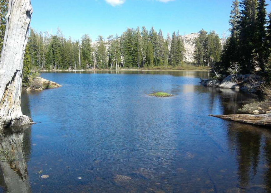
Five Lakes: The first lake arrives on your left. It’s not the prettiest of the bunch, but it’s the start. Beyond, you’ll see that two of the biggest lakes are connected. The biggest is my favorite, with gorgeous clear, blue water, edged by a granite slab on one side, peppered with boulders edged by forest on the other.
Popular, or not? You can often see high numbers of parked cars at the trailhead on Saturday afternoons and Sunday mornings. For those who have cabins and vacation homes in the north Tahoe area, the Five Lakes Trail is a popular day hike. Otherwise, many unfamiliar with Tahoe miss the trip. Once past the wilderness border, with five lakes to explore, you often see few people, and those few are happy to be there.
Cost: Parking and access are free.
Trail rules: Hikers, dogs and horses are permitted. No mountain bikes.
Maps/guidebooks: Tahoe National Forest, $10, Lake Tahoe Basin Management Unit, $10, at http://nationalforeststore.com; Lake Tahoe (recreation map), $10.95, at www.tomharrisonmaps.com; Moon California Hiking, $17, at www.amazon.com.
How to get there
From Sacramento, take Interstate 80 east for 90 miles to Truckee and Exit 185 for Highway 89. Take that exit, turn right, arc slightly on the roundabout, continue on Highway 89 and drive 9.8 miles (past Squaw Valley on the right) to Alpine Meadows Road. Turn right and drive 2.5 miles to the trailhead on the right (look for parked cars along the road; billboard and sign at trailhead).
Distances: 6.4 miles from Tahoe City, 13 miles from Truckee, 78 miles from Auburn, 112 miles from Sacramento, 198 miles from downtown San Francisco.
Contact: Tahoe National Forest, Truckee Ranger District, 10811 Stockrest Springs Road, Truckee; (530) 587-3558, www.fs.usda.gov/tahoe.
To see the original review and article in the San Francisco Chronicle newspaper, CLICK HERE.
What you’ll see: This is one of Tahoe’s best surprises, where an hour of hiking with a climb leads to five small, pretty lakes set in forest just inside the border of the Granite Chief Wilderness. You can turn it into a fortune hunt, to search out each of the lakes, and plan a trail picnic around the adventure.
Hike synopsis: 2.5 miles one way with a 1,000-foot climb, then a mosaic of routes in the forest lead to each lake. The return trip is an easy descent with canyon views. 5-mile round trip.
Trailhead: The trailhead is along the road that leads to the Alpine Meadows Ski Area on the north side of Lake Tahoe. As you drive in, look for a billboard (with a map) on the right and other cars parked along the road. The elevation is about 6,450 feet.
The trail: In the first mile, the trail does not resemble wilderness or even hint of a pristine payoff ahead. You climb up a canyon, steep at times, and hike up through a portion of Alpine Meadows and past a lift. There is no shade for much of it. Some who suffer from altitude or out-of-shape-itude can get discouraged. An early start is a plus, and so is a wide-brimmed hat. At about 7,000 feet, the climb becomes more rhythmic, and two miles in, you top a sub-ridge at 7,400 feet, pass the sign for the Granite Chief Wilderness and the trail flattens out as it enters the forest.
Five Lakes: The first lake arrives on your left. It’s not the prettiest of the bunch, but it’s the start. Beyond, you’ll see that two of the biggest lakes are connected. The biggest is my favorite, with gorgeous clear, blue water, edged by a granite slab on one side, peppered with boulders edged by forest on the other.
Popular, or not? You can often see high numbers of parked cars at the trailhead on Saturday afternoons and Sunday mornings. For those who have cabins and vacation homes in the north Tahoe area, the Five Lakes Trail is a popular day hike. Otherwise, many unfamiliar with Tahoe miss the trip. Once past the wilderness border, with five lakes to explore, you often see few people, and those few are happy to be there.
Cost: Parking and access are free.
Trail rules: Hikers, dogs and horses are permitted. No mountain bikes.
Maps/guidebooks: Tahoe National Forest, $10, Lake Tahoe Basin Management Unit, $10, at http://nationalforeststore.com; Lake Tahoe (recreation map), $10.95, at www.tomharrisonmaps.com; Moon California Hiking, $17, at www.amazon.com.
How to get there
From Sacramento, take Interstate 80 east for 90 miles to Truckee and Exit 185 for Highway 89. Take that exit, turn right, arc slightly on the roundabout, continue on Highway 89 and drive 9.8 miles (past Squaw Valley on the right) to Alpine Meadows Road. Turn right and drive 2.5 miles to the trailhead on the right (look for parked cars along the road; billboard and sign at trailhead).
Distances: 6.4 miles from Tahoe City, 13 miles from Truckee, 78 miles from Auburn, 112 miles from Sacramento, 198 miles from downtown San Francisco.
Contact: Tahoe National Forest, Truckee Ranger District, 10811 Stockrest Springs Road, Truckee; (530) 587-3558, www.fs.usda.gov/tahoe.
To see the original review and article in the San Francisco Chronicle newspaper, CLICK HERE.
 RSS Feed