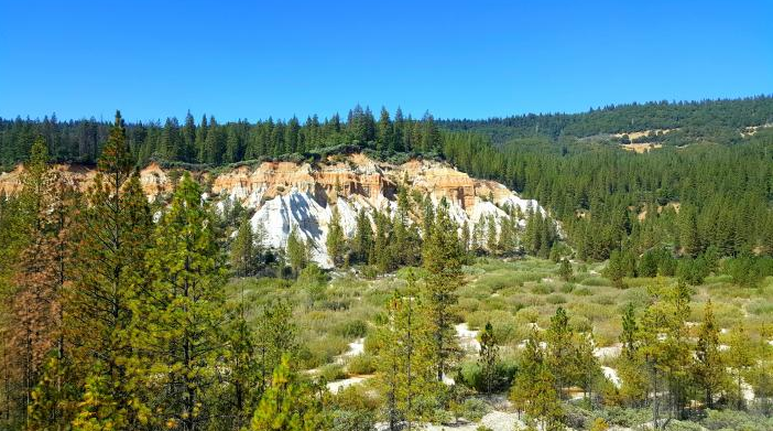
In the mid 1800s, Malakoff Diggins was the sight of the world’s largest hydraulic mining operation. Powerful canons blasted the hillsides reducing the towering layers of sedimentary rock, quartz and even gold to a pit of gravel. The monolithic volcanic rock was further eroded by the decades of wind and rain and shaped into the living museum that is the Malakoff Diggins State Historic Park. (Photo Credit: Mary West)
The best way to view the effects of hydraulic mining is a hiking trail just behind the town site marked Church Trail which leads to the Diggins Loop trail. On my last visit, I parked in front of the historic hotel site. A small wooden bridge that covers a seasonal creek begins the history lesson. Under your feet is river bed. Look up at the hills. You see areas covered with pine, other areas thick with manzanita and chamise. Still more areas devoid of any tree, bush or blade of glass. These are the hillsides blasted by water from the river to be sifted for gold.
Malakoff Diggins is the site of our country’s first environmental law issued by the federal government against the North Bloomfield Gravel Mining Company (Sawyer Decision) to curtail the release of the mud, gravel, and debris that clogged streams and major rivers from the foothills down to San Francisco Bay, according to Malakoffdigginsstatepark.org.
Church Trail starts with a brief greenbelt of pine. The first stop is a cemetery. Take a right around the cemetery and the trail leads downhill quickly to the dry river bed to the Diggins Loop Trail. Digggins Loop Trail is marked by posts painted yellow and accompanied by flagging tape. The trails takes you in a loop around the hydraulic mining pit. The trail follows the outer edges of the volcanic rock formations left behind. Underfoot is rock and sand. Following the trail posts you come to a boardwalk through a wetland. Turn right at the end of the board walk and begin the loop back. The sharp contrast in the coloring of the rock formations caught my eye. The red in the rock face is iron oxide. One formation in particular is purest white. Shaped by wind and weather into bold curves and sharp edges.
The loose rock demands sturdy hiking shoes or boots. Much of the trail is exposed to the sun so protection from burn is advised. There is significant elevation change so I will call the trail easy to moderate. Bring enough water to quench your thirst. Bring more water to overcome the arid quality the land has taken on following the effects of mining.
To get there from Auburn, take Highway 49 north to Nevada City where it turns left toward Downieville. Continue on toward North San Juan. Just short of town take a left on Tyler Foote Road. The road name changes to Cruzon Grade. Turn right onto Derbec Road. About one and half miles down the hill you arrive in historic North Bloomfield Road. One of the last buildings is the hotel on the right. Park and look across the open area through the trees. You will see the wooden bridge. Pass over it and walk into a past.
CLICK HERE to see the original article "Day Hiker - Sight trek to Malakoff Diggins" by Mary West, in The Union newspaper.
Mary is a retired radio personality and news reporter with a longtime love of the outdoors, sharing her favorite day hikes in Placer, Nevada, El Dorado and Yuba counties. Learn more about local trails by following Mary on Facebook, Twitter, Instagram, and YouTube.
 RSS Feed