Federal, State, Parks, Camps & Trails Links
WILDFIRE, MUDSLIDE, AND FLOOD CLOSURES CAN BE IN EFFECT IN CALIFORNIA PUBLIC LANDS,
INCLUDING STATE PARKS, NATIONAL PARKS AND COUNTY PARKS LISTED.
SEE MOTHER LODE TRAILS "ALERTS" TAB OR CONTACT THE LAND MANAGER.
INCLUDING STATE PARKS, NATIONAL PARKS AND COUNTY PARKS LISTED.
SEE MOTHER LODE TRAILS "ALERTS" TAB OR CONTACT THE LAND MANAGER.
FEDERAL, STATE, COUNTY DISTRICTS PARKS, CAMPS AND TRAILS
Placer, Yuba, and Nevada counties.
Click on any green link below for more information! Specific Parks and Trails information is below the General Trail Information group.
GENERAL TRAIL and CAMP INFORMATION
ALL USGS QUAD MAPS, downloadable and free from National Geographic
99 Horse Camp and Trail reports and reviews by Bob Sydnor
All Horse Camps in California
Pacific Crest Trail Interactive MAP
All Trails.com Interactive Map for the Mother Lode and Sierra trails
Back Country Horsemen Trail Resource and Eduction Library
Bear Yuba Land Trust trail cards
NEW! Bear Yuba Land Trust TRAILS PORTAL
BLM Maps of California Trails
California State Horsemen List of Horse Camps and Information
California State Parks Gold Country Region Trail Guide
NEW! California State Parks what3words APP
California Hiking Trails, organized by county
California Dept. Fish and Game Wildlife Areas, complete list
Cool Horse Trails
Day Hikes around Donner Summit
Events on the Trails in State Parks
Equestrian Campgrounds - Interactive Google Map
Georgetown Divide Equestrian Trails Foundation Trail Maps
NEW!! GOLD COUNTRY TRAILS COUNCIL GPX TRAIL FILES RESOURCE
Gold Country Area Mt. Bike Trails resourcemtbsingletrack.com/
The Hiking Project - trail maps for all trails
Horse Camps Project Map for California - Extensive
Horseback Riding and Horse Camping around Donner Summit
Meadow Vista Trails Asso. Trail maps of Placer and Nevada counties
Mt. Biking around Donner Summit
NEW!! - Northern California comprehensive list and reviews of hikes
National Trailmeister List of horse camps and trails (COMPREHENSIVE)
NEW!! Natural Trails Atlas www. NaturalAtlas.com
The OGRE Mt. Bike Trail Guide to the Central Sierras
Placer County trails, including in the American River Canyon and Trails in the American River Ranger District of the Tahoe National Forest,
Tahoe Horse Trails
Yuba-Sutter Trails Wiki
SPECIFIC CAMPS, PARKS AND TRAILS
American River Parkway directions and review
Auburn SRA - main California State Parks website
Auburn SRA - Auburn Overlook Staging Area Review
Auburn SRA - Confluence and Old Lime Stone Quarry Review
Baldwin Lake Trails and Review
Bayview Horse Trailhead - Emerald Bay
Big Meadow Trailhead and Review
Bear Yuba Land Trust Trails Portal
Black Swan Ranch Hike Report and Map
Cache Creek Ridge Natural Area BLM website
Camp Far West and Review
Cool Horse Trails
Cronan Ranch Regional Trails Park, BLM Guide, Cronan Ranch Trailhead
Cronan Ranch Regional Trails Park, BLM Guide Magnolia Staging
Cronan Ranch Regional Trails Park - Cronan to Magnolia connector trail
Dru Barner Equestrian Park REVIEW AND REPORT
Dru Barner Equestrian Park Horse Camp Information
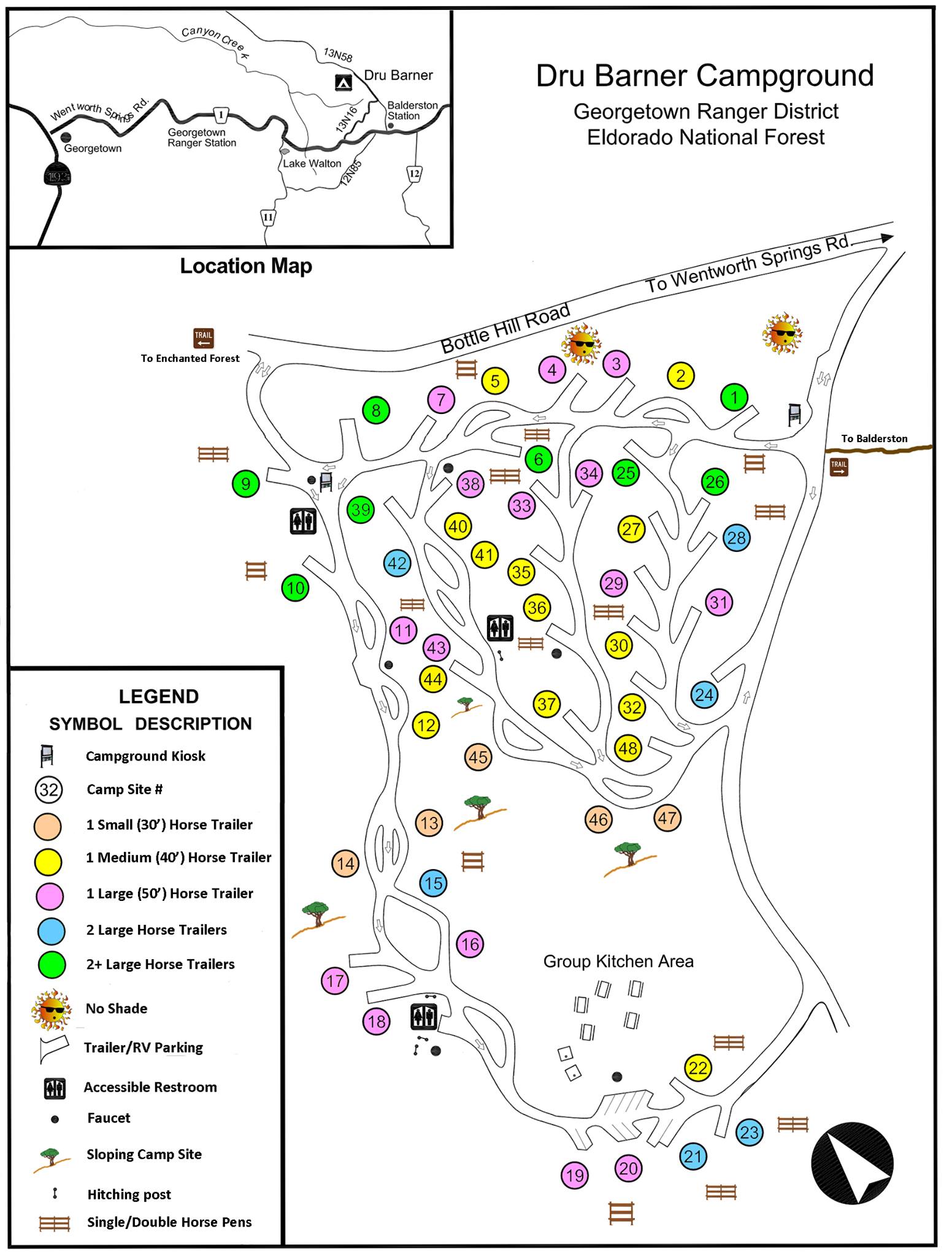
NEW!! Dru Barner Equestrian Park Camp Site Detail Map
Dru Barner Equestrian Park Horse Camp Info and Map
Dru Barner Equestrian Park Directions, Bandana Map, Review
NEW!! Dru Barner GPX trail resource page provided by Gold Country Trails Council
Eldorado National Forest Visitor Guide
Eldorado National Forest - list of Best Trails
Eldorado National Forest - Bayview Horse Trailhead, Emerald Bay Review and pictures
Eldorado National Forest - Caples Creek Horse Camp and Equestrian Trailhead
Eldorado National Forest - Wright's Lake Equestrian Camp review
Empire Mine
Empire Mine Map and Brochure
Empire Mine Osborn Loop trail review
Empire Mine Trails and Review
Empire Mine - Sierra Gold Parks Foundation information
NEW!! Empire Mine GPX trail resource page provided by Gold Country Trails Council
Folsom Lake SRA - Main California State Parks Website
Folsom Lake SRA - Trails Map in proposed General Plan
Folsom Lake SRA - Official Trails Map, Lake Natoma and detail for Folsom Powerhouse
Folsom Lake SRA - Official Trails Map, Main Body Folsom Lake and detail for Beals Point and Dikes 4-6
Folsom Lake SRA - Official Trails Map, North Fork arm and detail for Granite Bay
Folsom Lake SRA - Official Trails Map, South Fork arm detail for South Granite Bay and Monte Vista
Folsom Lake SRA Trails Map
Folsom Lake SRA - Avery's Pond, North Fork of the American River, Pioneer Express Trail, Milepost 47.5 and Review
Folsom Lake SRA - Falcon Crest Trails, review and lots of pictures
Folsom Lake SRA - Falcon Crest (Monte Vista) Directions and Review
Folsom Lake SRA - Granite Bay Assembly Area pictures and review
Folsom Lake SRA - Granite Bay to Beals Point on the Pioneer Express Trail Review
Folsom Lake SRA - Sterling Pointe Equestrian Staging Area Photos and Review
Folsom Lake SRA - Lake Natoma and Negro Bar Equestrian Staging Area, Folsom Lake SRA
Folsom Lake SRA and Placer County Parks - Peregrine Trail Pictures and Review
Folsom Lake SRA - The Middle Trail, Granite Bay area, Folsom Lake SRA and Review
Folsom Lake SRA - Pioneer Express Trail at Folsom Dam Crossing Review
Folsom Lake SRA - Beeks Bight Trail, Granite Bay area, Folsom Lake SRA and Review
Folsom Lake SRA - The historic 1854 North Fork Ditch visible along the Beach Trail between Sterling Pointe and Beeks Bight, Folsom Lake SRA and Review
NEW! Folsom Lake SRA - Salmon Falls Bridge Trail (Darrington Trail) Review and pictures
Folsom Lake SRA, South Fork American River Trail MAP
Folsom Lake SRA - South Fork Arm Map
NEW!! Folsom Lake SRA - GPX trail resource page provided by Gold Country Trails Council
Foresthill Divide Loop and Review
Gold Country Equestrian Trailhead - Nevada County
Gold Country Trails Council supplies for Highway 20 area - Harmony Ridge Market
NEW!! Gold Country Equestrian Trailhead GPX trail resource page provided by Gold Country Trails Council
Grass Valley and Nevada City area trails map and list by Nevada County Land Trust
Hidden Falls Regional Park Map
Hidden Falls Regional Park, Blue Oaks Loop Trail Review
Hidden Falls Regional Park, Canyon View Trail
Hidden Falls Regional Park, Creekside Trail Review
Hidden Falls Regional Park - Deer Trail Review
Hidden Falls Regional Park, Gold Finch Trail and the Great Egret Trail Review
Hidden Falls Regional Park, Golden Eagle Loop Trail Review
Hidden Falls Regional Park Gray Squirrel Trail Review
Hidden Falls Regional Park, Pheasant Trail Review
Hidden Falls Regional Park - Poppy Trail Review
Hidden Falls Regional Park, River Otter Loop Trail Review
Hidden Falls Regional Park, Seven Pools Trail Review
Hidden Falls Regional Park WEBCAM for parking
NEW!! Hidden Falls Regional Park GPX trail resource page provided by Gold Country Trails Council
High Sierra Horse Camp and trails (privately run, open to the public)
Historic Donner Trail
Lake Oroville SRA main
Lake Oroville SRA brochure and map
Lake Oroville SRA Loafer Creek Horse Camp Report and Review
Lake Oroville SRA Loafer Creek Horse Camp Trailmeister maps and review
Lakeland Equestrian Area at Lake Oroville SRA
Lake Tahoe Trails and Reviews
Little Lasier Meadows Horse Camp
Loney Meadow Horse Camp, Trails and Review
Loney Meadow - Grouse Lakes Area and Review
NEW!! Loney Meadow- Grouse Ridge GPX trail resource page provided by Gold Country Trails Council
Malakoff Diggins SHA
NEW! Malakoff Diggins SHA - Sierra Gold Parks Foundation information
Meadow Vista Trails
Winchester Trail (Meadow Vista) and Review
Nevada County trails and recreation
Northern California Hiking Opportunities in State Parks
Northern California Hikes and Reviews
North Yuba Trail Reviews
Pacific Crest Trail TRAIL CLOSURE WEBSITE
Placer County Trails, a complete guide
Placer County trails, parks and recreation information
Placer County Land Trust Trails
Plumas National Forest - Bucks Lake, Whitehorse Campground and trails, short MOVIE
Point Reyes and Stewarts Horse Camp is out of our area, but visited frequently by our community:
TWELVE Pt. Reyes Maps - free!
Pt. Reyes National Seashore
Pt. Reyes Trail Maps
Pt. Reyes - Five Brooks Horse Camp (privately run, open to the public, previously Stewarts) Call Andy 415-663-1570
Rice's Crossing Preserve
Robie Equestrian Park information and review (privately run, open to the public)
Robie Equestrian Park Foundation Guide
Robie Equestrian Park Trail Map
Sacramento Regional Parks - Main website
Sacramento Regional Parks - American River Parkway
Sacramento Regional Parks - Regional Parks main page
Sacramento Regional Parks - Elk Grove Regional Park main page
Sacramento Regional Parks - Dry Creek Parkway main page
Sacramento Regional Parks - Gibson Ranch Regional Park main page
Silver Lake Trails and Review
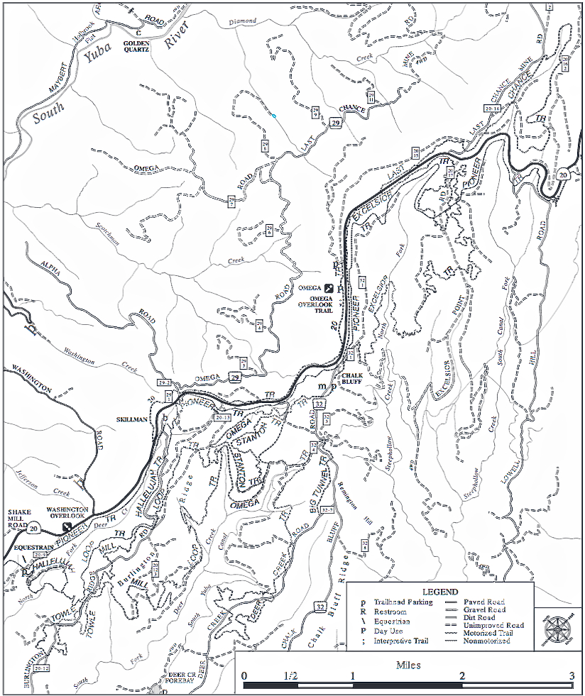
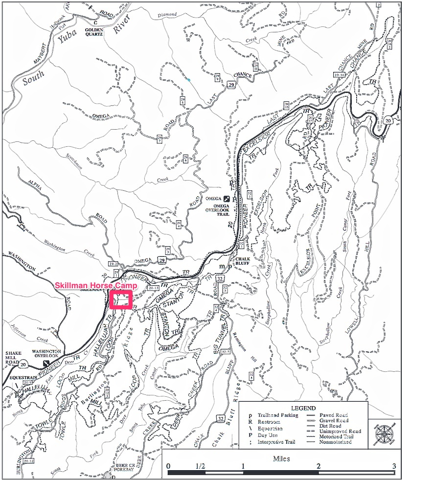
Skillman Horse Camp
Skillman Horse Camp Facebook community
NEW!! Skillman Horse Camp GPX trail file resource page provided by Gold Country Trails Council
Sly Park Recreation Area
Sly Park Recreation Area - Main website
Sly Park Recreation Area - Trail Maps
Sly Park Recreation Area - Black Oak Horse Camp
Sly Park and Review
Sly Park Recreation Area - Jenkinson Lake
Sly Park Trails
Spenceville Wildlife Area
Spenceville Wildlife Preserve, Equestrian Trails, Review
Spenceville Wildlife Area, Friends of - maps, information
NEW!! Spenceville Wildlife Area GPX trail file resources provided by Gold Country Trails Council
South Fork American River Trail MAP
South Yuba Recreation Area MAP - BLM .
South Yuba Recreation Area BLM information
South Yuba Trails
South Yuba IMBA EPIC mt. bike trail
NEW! South Yuba River State Park - Sierra Gold Parks Foundation information
Stevens Trail in Colfax
Tahoe Donner Land Trust free trails map app
Tahoe Donner Equestrian Center trails - Euer Valley - PRIVATE
Tahoe National Forest
Tahoe National Forest - Trail maps and descriptions for the American River Ranger District
Tahoe National Forest motorized and non-motorized trails on the Highway 20 corridor
Tahoe National Forest - Castle Peak Directions and Review
Tahoe National Forest - Horse Camps and Trail Maps
Tahoe National Forest - Little Lasier Meadows Horse Camp
NEW! Tahoe National Forest - Little Lasier Meadows Horse Camp CSHA information
Tahoe National Forest - Lone Grave and Gold Country Trails Council Staging and Review
Tahoe National Forest - Lone Grave Map and trails description
Tahoe National Forest - Loney Meadow Horse Camp, Trails and Review
Tahoe National Forest - Loney Meadow Horse Camp area, trails and lakes, SF Chronicle review
Tahoe National Forest - Omega Overlook road bypass trail
Loney Meadow - Grouse Lakes Area and Review
Tahoe National Forest - Packsaddle Horse Campground Review, maps, photos
Tahoe National Forest - Robinson Flat Equestrian Camp information and review
Tahoe National Forest - Robinson Flat, Foresthill Road, Little Bald Mountain Loop Rail Review
Tahoe National Forest - Scotts Flat Trail (mt. bike trail) map
Tahoe National Forest - Skillman Horse Camp review
Tahoe National Forest - Skillman Horse Camp
Tahoe National Forest - Skillman Horse Camp trails map
Tahoe National Forest - Skillman Horse Camp Facebook page
Tahoe National Forest - Truckee, Sawtooth Trail Review
Tahoe National Forest Camp Information List
NEW!! Tahoe National Forest GPX trail file resources provided by Gold Country Trails Council
Tahoe Horse Trails
Tahoe Rim IMBA EPIC Trail
Tahoe Rim Trail
Tahoe 5 Lakes Trail SF Chronicle REVIEW
NEW! Tahoe Pyramid Trail - Truckee Canyon to Verdi maps
Traylor Ranch Nature Preserve Trails and Review
Truckee Area Hiking Trails
Webber Lake - Trail Map and information
Weimar Institute (privately owned, open to the public)
Weimar Institute Trails Review
Western States Trail - MAP
Western States Trail - the California Loop Review
Western States Trail - Deadwood to Michigan Bluff Review
Western States Trail - Michigan Bluff to El Dorado Bridge section, trail review
Yuba River Park Trails
Yuba Sutter Trails Wiki
Placer, Yuba, and Nevada counties.
Click on any green link below for more information! Specific Parks and Trails information is below the General Trail Information group.
GENERAL TRAIL and CAMP INFORMATION
ALL USGS QUAD MAPS, downloadable and free from National Geographic
99 Horse Camp and Trail reports and reviews by Bob Sydnor
All Horse Camps in California
Pacific Crest Trail Interactive MAP
All Trails.com Interactive Map for the Mother Lode and Sierra trails
Back Country Horsemen Trail Resource and Eduction Library
Bear Yuba Land Trust trail cards
NEW! Bear Yuba Land Trust TRAILS PORTAL
BLM Maps of California Trails
California State Horsemen List of Horse Camps and Information
California State Parks Gold Country Region Trail Guide
NEW! California State Parks what3words APP
California Hiking Trails, organized by county
California Dept. Fish and Game Wildlife Areas, complete list
Cool Horse Trails
Day Hikes around Donner Summit
Events on the Trails in State Parks
Equestrian Campgrounds - Interactive Google Map
Georgetown Divide Equestrian Trails Foundation Trail Maps
NEW!! GOLD COUNTRY TRAILS COUNCIL GPX TRAIL FILES RESOURCE
Gold Country Area Mt. Bike Trails resourcemtbsingletrack.com/
The Hiking Project - trail maps for all trails
Horse Camps Project Map for California - Extensive
Horseback Riding and Horse Camping around Donner Summit
Meadow Vista Trails Asso. Trail maps of Placer and Nevada counties
Mt. Biking around Donner Summit
NEW!! - Northern California comprehensive list and reviews of hikes
National Trailmeister List of horse camps and trails (COMPREHENSIVE)
NEW!! Natural Trails Atlas www. NaturalAtlas.com
The OGRE Mt. Bike Trail Guide to the Central Sierras
Placer County trails, including in the American River Canyon and Trails in the American River Ranger District of the Tahoe National Forest,
Tahoe Horse Trails
Yuba-Sutter Trails Wiki
SPECIFIC CAMPS, PARKS AND TRAILS
American River Parkway directions and review
Auburn SRA - main California State Parks website
Auburn SRA - Auburn Overlook Staging Area Review
Auburn SRA - Confluence and Old Lime Stone Quarry Review
Baldwin Lake Trails and Review
Bayview Horse Trailhead - Emerald Bay
Big Meadow Trailhead and Review
Bear Yuba Land Trust Trails Portal
Black Swan Ranch Hike Report and Map
Cache Creek Ridge Natural Area BLM website
Camp Far West and Review
Cool Horse Trails
Cronan Ranch Regional Trails Park, BLM Guide, Cronan Ranch Trailhead
Cronan Ranch Regional Trails Park, BLM Guide Magnolia Staging
Cronan Ranch Regional Trails Park - Cronan to Magnolia connector trail
Dru Barner Equestrian Park REVIEW AND REPORT
Dru Barner Equestrian Park Horse Camp Information
NEW!! Dru Barner Equestrian Park Camp Site Detail Map
Dru Barner Equestrian Park Horse Camp Info and Map
Dru Barner Equestrian Park Directions, Bandana Map, Review
NEW!! Dru Barner GPX trail resource page provided by Gold Country Trails Council
Eldorado National Forest Visitor Guide
Eldorado National Forest - list of Best Trails
Eldorado National Forest - Bayview Horse Trailhead, Emerald Bay Review and pictures
Eldorado National Forest - Caples Creek Horse Camp and Equestrian Trailhead
Eldorado National Forest - Wright's Lake Equestrian Camp review
Empire Mine
Empire Mine Map and Brochure
Empire Mine Osborn Loop trail review
Empire Mine Trails and Review
Empire Mine - Sierra Gold Parks Foundation information
NEW!! Empire Mine GPX trail resource page provided by Gold Country Trails Council
Folsom Lake SRA - Main California State Parks Website
Folsom Lake SRA - Trails Map in proposed General Plan
Folsom Lake SRA - Official Trails Map, Lake Natoma and detail for Folsom Powerhouse
Folsom Lake SRA - Official Trails Map, Main Body Folsom Lake and detail for Beals Point and Dikes 4-6
Folsom Lake SRA - Official Trails Map, North Fork arm and detail for Granite Bay
Folsom Lake SRA - Official Trails Map, South Fork arm detail for South Granite Bay and Monte Vista
Folsom Lake SRA Trails Map
Folsom Lake SRA - Avery's Pond, North Fork of the American River, Pioneer Express Trail, Milepost 47.5 and Review
Folsom Lake SRA - Falcon Crest Trails, review and lots of pictures
Folsom Lake SRA - Falcon Crest (Monte Vista) Directions and Review
Folsom Lake SRA - Granite Bay Assembly Area pictures and review
Folsom Lake SRA - Granite Bay to Beals Point on the Pioneer Express Trail Review
Folsom Lake SRA - Sterling Pointe Equestrian Staging Area Photos and Review
Folsom Lake SRA - Lake Natoma and Negro Bar Equestrian Staging Area, Folsom Lake SRA
Folsom Lake SRA and Placer County Parks - Peregrine Trail Pictures and Review
Folsom Lake SRA - The Middle Trail, Granite Bay area, Folsom Lake SRA and Review
Folsom Lake SRA - Pioneer Express Trail at Folsom Dam Crossing Review
Folsom Lake SRA - Beeks Bight Trail, Granite Bay area, Folsom Lake SRA and Review
Folsom Lake SRA - The historic 1854 North Fork Ditch visible along the Beach Trail between Sterling Pointe and Beeks Bight, Folsom Lake SRA and Review
NEW! Folsom Lake SRA - Salmon Falls Bridge Trail (Darrington Trail) Review and pictures
Folsom Lake SRA, South Fork American River Trail MAP
Folsom Lake SRA - South Fork Arm Map
NEW!! Folsom Lake SRA - GPX trail resource page provided by Gold Country Trails Council
Foresthill Divide Loop and Review
Gold Country Equestrian Trailhead - Nevada County
Gold Country Trails Council supplies for Highway 20 area - Harmony Ridge Market
NEW!! Gold Country Equestrian Trailhead GPX trail resource page provided by Gold Country Trails Council
Grass Valley and Nevada City area trails map and list by Nevada County Land Trust
Hidden Falls Regional Park Map
Hidden Falls Regional Park, Blue Oaks Loop Trail Review
Hidden Falls Regional Park, Canyon View Trail
Hidden Falls Regional Park, Creekside Trail Review
Hidden Falls Regional Park - Deer Trail Review
Hidden Falls Regional Park, Gold Finch Trail and the Great Egret Trail Review
Hidden Falls Regional Park, Golden Eagle Loop Trail Review
Hidden Falls Regional Park Gray Squirrel Trail Review
Hidden Falls Regional Park, Pheasant Trail Review
Hidden Falls Regional Park - Poppy Trail Review
Hidden Falls Regional Park, River Otter Loop Trail Review
Hidden Falls Regional Park, Seven Pools Trail Review
Hidden Falls Regional Park WEBCAM for parking
NEW!! Hidden Falls Regional Park GPX trail resource page provided by Gold Country Trails Council
High Sierra Horse Camp and trails (privately run, open to the public)
Historic Donner Trail
Lake Oroville SRA main
Lake Oroville SRA brochure and map
Lake Oroville SRA Loafer Creek Horse Camp Report and Review
Lake Oroville SRA Loafer Creek Horse Camp Trailmeister maps and review
Lakeland Equestrian Area at Lake Oroville SRA
Lake Tahoe Trails and Reviews
Little Lasier Meadows Horse Camp
Loney Meadow Horse Camp, Trails and Review
Loney Meadow - Grouse Lakes Area and Review
NEW!! Loney Meadow- Grouse Ridge GPX trail resource page provided by Gold Country Trails Council
Malakoff Diggins SHA
NEW! Malakoff Diggins SHA - Sierra Gold Parks Foundation information
Meadow Vista Trails
Winchester Trail (Meadow Vista) and Review
Nevada County trails and recreation
Northern California Hiking Opportunities in State Parks
Northern California Hikes and Reviews
North Yuba Trail Reviews
Pacific Crest Trail TRAIL CLOSURE WEBSITE
Placer County Trails, a complete guide
Placer County trails, parks and recreation information
Placer County Land Trust Trails
Plumas National Forest - Bucks Lake, Whitehorse Campground and trails, short MOVIE
Point Reyes and Stewarts Horse Camp is out of our area, but visited frequently by our community:
TWELVE Pt. Reyes Maps - free!
Pt. Reyes National Seashore
Pt. Reyes Trail Maps
Pt. Reyes - Five Brooks Horse Camp (privately run, open to the public, previously Stewarts) Call Andy 415-663-1570
Rice's Crossing Preserve
Robie Equestrian Park information and review (privately run, open to the public)
Robie Equestrian Park Foundation Guide
Robie Equestrian Park Trail Map
Sacramento Regional Parks - Main website
Sacramento Regional Parks - American River Parkway
Sacramento Regional Parks - Regional Parks main page
Sacramento Regional Parks - Elk Grove Regional Park main page
Sacramento Regional Parks - Dry Creek Parkway main page
Sacramento Regional Parks - Gibson Ranch Regional Park main page
Silver Lake Trails and Review
Skillman Horse Camp
Skillman Horse Camp Facebook community
NEW!! Skillman Horse Camp GPX trail file resource page provided by Gold Country Trails Council
Sly Park Recreation Area
Sly Park Recreation Area - Main website
Sly Park Recreation Area - Trail Maps
Sly Park Recreation Area - Black Oak Horse Camp
Sly Park and Review
Sly Park Recreation Area - Jenkinson Lake
Sly Park Trails
Spenceville Wildlife Area
Spenceville Wildlife Preserve, Equestrian Trails, Review
Spenceville Wildlife Area, Friends of - maps, information
NEW!! Spenceville Wildlife Area GPX trail file resources provided by Gold Country Trails Council
South Fork American River Trail MAP
South Yuba Recreation Area MAP - BLM .
South Yuba Recreation Area BLM information
South Yuba Trails
South Yuba IMBA EPIC mt. bike trail
NEW! South Yuba River State Park - Sierra Gold Parks Foundation information
Stevens Trail in Colfax
Tahoe Donner Land Trust free trails map app
Tahoe Donner Equestrian Center trails - Euer Valley - PRIVATE
Tahoe National Forest
Tahoe National Forest - Trail maps and descriptions for the American River Ranger District
- Deadwood to Michigan Bluff Trail (segment of the Western States Trail)
- Little Bald Mountain Trail
- Joshua M. Hardt Memorial Trail
- Green Valley Trail
- Euchre Bar Trail
- Italian Bar Trail
- Mumford Bar Trail
- American River Trail
- Beacroft Trail
- Sailor Flat Trail
- Loch Leven Lakes Trail System
- North Fork of the Middle Fork Trail
- Mosquito Ridge Trail
- Grouse Falls Big Trees Loop
- Forest View Trails
- McGuire Trail (segment of Western States Trail)
Tahoe National Forest motorized and non-motorized trails on the Highway 20 corridor
Tahoe National Forest - Castle Peak Directions and Review
Tahoe National Forest - Horse Camps and Trail Maps
Tahoe National Forest - Little Lasier Meadows Horse Camp
NEW! Tahoe National Forest - Little Lasier Meadows Horse Camp CSHA information
Tahoe National Forest - Lone Grave and Gold Country Trails Council Staging and Review
Tahoe National Forest - Lone Grave Map and trails description
Tahoe National Forest - Loney Meadow Horse Camp, Trails and Review
Tahoe National Forest - Loney Meadow Horse Camp area, trails and lakes, SF Chronicle review
Tahoe National Forest - Omega Overlook road bypass trail
Loney Meadow - Grouse Lakes Area and Review
Tahoe National Forest - Packsaddle Horse Campground Review, maps, photos
Tahoe National Forest - Robinson Flat Equestrian Camp information and review
Tahoe National Forest - Robinson Flat, Foresthill Road, Little Bald Mountain Loop Rail Review
Tahoe National Forest - Scotts Flat Trail (mt. bike trail) map
Tahoe National Forest - Skillman Horse Camp review
Tahoe National Forest - Skillman Horse Camp
Tahoe National Forest - Skillman Horse Camp trails map
Tahoe National Forest - Skillman Horse Camp Facebook page
Tahoe National Forest - Truckee, Sawtooth Trail Review
Tahoe National Forest Camp Information List
NEW!! Tahoe National Forest GPX trail file resources provided by Gold Country Trails Council
Tahoe Horse Trails
Tahoe Rim IMBA EPIC Trail
Tahoe Rim Trail
Tahoe 5 Lakes Trail SF Chronicle REVIEW
NEW! Tahoe Pyramid Trail - Truckee Canyon to Verdi maps
Traylor Ranch Nature Preserve Trails and Review
Truckee Area Hiking Trails
Webber Lake - Trail Map and information
Weimar Institute (privately owned, open to the public)
Weimar Institute Trails Review
Western States Trail - MAP
Western States Trail - the California Loop Review
Western States Trail - Deadwood to Michigan Bluff Review
Western States Trail - Michigan Bluff to El Dorado Bridge section, trail review
Yuba River Park Trails
Yuba Sutter Trails Wiki
If you have a reference you would like added to this list, to email your URL link CLICK HERE