Originally called Mother Lode Mountain Biking, leaders are changing the organization’s name and become a chapter of IMBA. (There is a concern that the bike group's new name is almost identical to this 10 year old 501c3 nonprofit, Mother Lode Trails, and that they have taken over the Mother Lode Trails Instagram account.) They are planning to develop trails on the West Slope of the EDC along the Hwy 50 and 49 corridors, with a particular interest in Crronan Ranch.
(Mountain Democrat photo by Kevin Christensen)
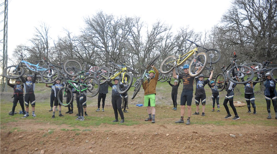
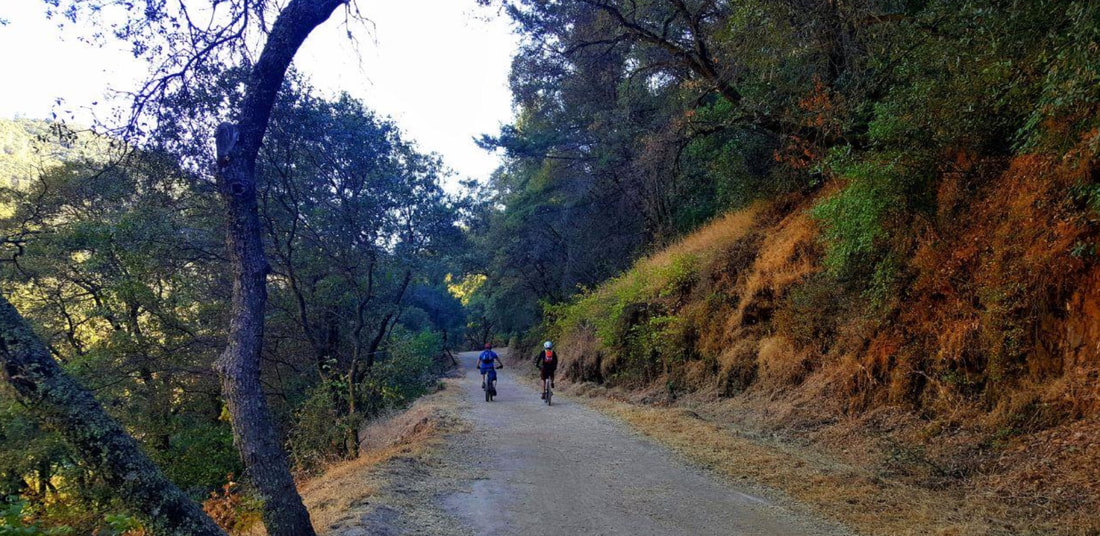
Whether it be boating down the South Fork of the American River or hiking in the scenic Sierra, El Dorado County is a mecca for outdoor enthusiasts. A trailblazing organization, the newly formed Mother Lode Trail Stewardship, is seeking to create, maintain and enhance sustainable recreational trails in the county for even more recreational opportunities — and as a result assist the local economy.
To see the original article and photos in the Mountain Democrat newspaper, CLICK HERE.
Headed by Shingle Springs resident Ethan Koenigs, MLTS’ mission is to build trails “inclusively” for mountain bikers, hikers, runners and horseback riders with an emphasis on connecting trails to community centers.
The group has the notion that trail users will take advantage of local shops, eateries and drinking establishments in the county.
“Having a robust recreational trail system connected to the community I believe will benefit local businesses,” said Koenigs, an environmental project manager with SMUD. “Trail users will inevitably spend money at small businesses in the county if they can gain access to them beyond driving.”
Originally called Mother Lode Mountain Biking, Koenigs, also an avid hiker, and other MLTS leaders decided to change the organization’s name once they realized a more inclusive approach could gain broader support locally. The trail advocates wish to create a community connected by paths that has features “all users can enjoy.”
“A ‘bigger tent’ of members means more benefit to the community and will increase our ability to raise funds,” Koenigs said.
Another MLTS goal, becoming a chapter of the International Mountain Bike Association, will allow it to take advantage of a larger pool of resources for education, promotions and membership acquisition.
The region currently has two other mountain bike advocacy groups, Tahoe Area Mountain Bike Association and Folsom-Auburn Trail Riding Action Coalition, that have geographic overlap. MLTS’ focus will be on the West Slope of EDC along the Highway 50 and 49 corridors.
One new trail planned in the area will be a 12 to 15 mile mountain bike trail between Ice House and Union Valley reservoirs — along with other recreational facilities — as part of SMUD’s new Federal Energy Regulatory Commission license agreement to operate its hydroelectric facility in the Crystal Basin Recreation Area of the Eldorado National Forest.
“The new trail in the Ice House Reservoir area will be a major new recreation feature for mountain bikers looking for something new that is built and designed professionally,” Koenigs explained.
Koenigs said MLTS also has particular interest in developing the Cronan Ranch area and connecting Coloma and Lotus.
“That area is already a mecca because of the amazing whitewater rafting,” Koenigs said. “Why not build off of that and have amazing trails that people can use year-round and help some of the businesses that suffer in the whitewater off-season.”
MLTS members also see potential for new trails in the Sly Park area and El Dorado Hills where Koenigs said there is a “fair amount of open space with a large population hungry for new trail experiences.”
Other areas on the group’s radar include the new Marble Valley development south of Highway 50 near Cameron Park and improving a “terrific network of trails” on the Georgetown Divide.
“The MLTS is very interested in helping the design of the Marble Valley area because there’s potential for connection to the town center in El Dorado Hills,” Koenigs said. “The El Dorado Trail is already serving as a connector and it could be further developed to support a diversity of uses and eventually a network of new trails could connect to that.”
A “turning point” came for Koenigs on undertaking the trailblazing effort during a visit to Bentonville, Ark., in 2019 where he witnessed first-hand how much the city invested in trails.
“The whole community in Bentonville got on board with the concept after they built a few really cool trails that connected right into their downtown area,” said Koenigs. “As a result they saw the tremendous benefit to local businesses, overall community health and more. Word spread quickly and it snow-balled into the city reaping huge economic rewards as it is now a world-class destination for mountain bikers.”
Koenigs said MLTS will seek out grants and raise funds through events and local business sponsors, but the “only way this works” is if they get buy-in from the trail-using public with a willingness to serve and volunteer their time to help.
MLTS is holding its next meeting Thursday, Jan. 30 at 6:30 p.m. at Solid Ground Brewery in Diamond Springs.
For more information on Mother Lode Trail Stewardship visit motherlodestewardship.org or call (530) 208-9947.
-----
To see the original article and photos in the Mountain Democrat newspaper, CLICK HERE.
(Mountain Democrat photo by Kevin Christensen)
Whether it be boating down the South Fork of the American River or hiking in the scenic Sierra, El Dorado County is a mecca for outdoor enthusiasts. A trailblazing organization, the newly formed Mother Lode Trail Stewardship, is seeking to create, maintain and enhance sustainable recreational trails in the county for even more recreational opportunities — and as a result assist the local economy.
To see the original article and photos in the Mountain Democrat newspaper, CLICK HERE.
Headed by Shingle Springs resident Ethan Koenigs, MLTS’ mission is to build trails “inclusively” for mountain bikers, hikers, runners and horseback riders with an emphasis on connecting trails to community centers.
The group has the notion that trail users will take advantage of local shops, eateries and drinking establishments in the county.
“Having a robust recreational trail system connected to the community I believe will benefit local businesses,” said Koenigs, an environmental project manager with SMUD. “Trail users will inevitably spend money at small businesses in the county if they can gain access to them beyond driving.”
Originally called Mother Lode Mountain Biking, Koenigs, also an avid hiker, and other MLTS leaders decided to change the organization’s name once they realized a more inclusive approach could gain broader support locally. The trail advocates wish to create a community connected by paths that has features “all users can enjoy.”
“A ‘bigger tent’ of members means more benefit to the community and will increase our ability to raise funds,” Koenigs said.
Another MLTS goal, becoming a chapter of the International Mountain Bike Association, will allow it to take advantage of a larger pool of resources for education, promotions and membership acquisition.
The region currently has two other mountain bike advocacy groups, Tahoe Area Mountain Bike Association and Folsom-Auburn Trail Riding Action Coalition, that have geographic overlap. MLTS’ focus will be on the West Slope of EDC along the Highway 50 and 49 corridors.
One new trail planned in the area will be a 12 to 15 mile mountain bike trail between Ice House and Union Valley reservoirs — along with other recreational facilities — as part of SMUD’s new Federal Energy Regulatory Commission license agreement to operate its hydroelectric facility in the Crystal Basin Recreation Area of the Eldorado National Forest.
“The new trail in the Ice House Reservoir area will be a major new recreation feature for mountain bikers looking for something new that is built and designed professionally,” Koenigs explained.
Koenigs said MLTS also has particular interest in developing the Cronan Ranch area and connecting Coloma and Lotus.
“That area is already a mecca because of the amazing whitewater rafting,” Koenigs said. “Why not build off of that and have amazing trails that people can use year-round and help some of the businesses that suffer in the whitewater off-season.”
MLTS members also see potential for new trails in the Sly Park area and El Dorado Hills where Koenigs said there is a “fair amount of open space with a large population hungry for new trail experiences.”
Other areas on the group’s radar include the new Marble Valley development south of Highway 50 near Cameron Park and improving a “terrific network of trails” on the Georgetown Divide.
“The MLTS is very interested in helping the design of the Marble Valley area because there’s potential for connection to the town center in El Dorado Hills,” Koenigs said. “The El Dorado Trail is already serving as a connector and it could be further developed to support a diversity of uses and eventually a network of new trails could connect to that.”
A “turning point” came for Koenigs on undertaking the trailblazing effort during a visit to Bentonville, Ark., in 2019 where he witnessed first-hand how much the city invested in trails.
“The whole community in Bentonville got on board with the concept after they built a few really cool trails that connected right into their downtown area,” said Koenigs. “As a result they saw the tremendous benefit to local businesses, overall community health and more. Word spread quickly and it snow-balled into the city reaping huge economic rewards as it is now a world-class destination for mountain bikers.”
Koenigs said MLTS will seek out grants and raise funds through events and local business sponsors, but the “only way this works” is if they get buy-in from the trail-using public with a willingness to serve and volunteer their time to help.
MLTS is holding its next meeting Thursday, Jan. 30 at 6:30 p.m. at Solid Ground Brewery in Diamond Springs.
For more information on Mother Lode Trail Stewardship visit motherlodestewardship.org or call (530) 208-9947.
-----
To see the original article and photos in the Mountain Democrat newspaper, CLICK HERE.
 RSS Feed