MOTHER LODE TRAILS
  • Home
  • About
  • Contact
  • Volunteer
  • Links
    • Law Enforcement Emergency
    • Federal, State, County Districts Parks & Trails
    • Running Clubs
    • Equestrian Clubs
    • Mt. Bike Clubs
    • Hiking Clubs
    • Trail Advocacy Organizations
    • Phone Numbers State & Federal Parks, Trails & Lands
    • Where to Eat on the Trails
  • News
  • Alerts

Hike the Royal Gorge trails, include "Thauvette's Frolic"

6/20/2018

 
Picture
From the Truckee-Donner Land Trust News:
Summer is here and the snow has melted from most Royal Gorge trails on Donner Summit, giving way to bright green foliage, blooming flowers and sweeping views – making now the time to hit the trail.
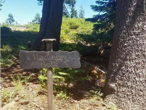
Thauvette's Frolic, named for former Truckee Donner Land Trust Board President Bill Thauvette, is a great trail that links to many others, giving you the opportunity to hike as far, or short, as you want.
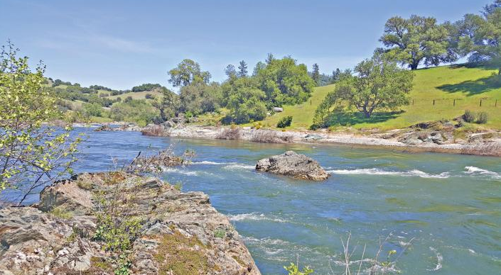
Start at the Summit Station Trailhead at the end of Pahatsi Road in Soda Springs to take Thauvette's Frolic, linking any number of the great trails at Royal Gorge replete with views of Castle Peak and the Upper South Yuba Basin. Wildflowers, including corn lilies, leopard lilies, delphinium, penstemon and more start blooming this time of year, lasting into mid to late july. The trail features a bench at a scenic overlook for a short evening stroll.
Associate Director John Svahn's favorite loop starts on Big Ben Trail to Buckeye Trail, then connecting Thauvette's Frolic to Hellman's Way Trail and Castle Pass, which brings hikers to a beautiful stand of mature red fir. Take Reindeer back to the trailhead to complete the loop. An out-and-back on the Point Mariah Trail can be added to reach a beautiful overlook of the North Fork of the American River.

Please note: While Thauvette's Frolic is a foot trail, most Royal Gorge trails are open to mountain biking.

To read the original article and see photos, CLICK HERE.

Find more information on Donner Summit hiking here.


Buttermilk Bend Trail on the Yuba

6/16/2018

 
Picture
Hike this trail in early spring when you have to dodge butterflies. Take in the panoramic view of the Yuba River but don’t forget to enjoy the variety of wildflowers at your feet. Appreciate the rock benches and well maintained trail and ignore the parking and mass of people you will share this trail with. Take the dog but make sure you have them on a leash. Enjoy the blissful suffering of a high traffic, but amazing, trail at its peak.

This trail used to be our little secret. I blame social media for its rise in popularity. But do it anyway. Then after you have enjoyed the spring time version of this trail, come back. Come back during the week. Come early in the morning or late in the afternoon. Come back in every season.

The sound of the river pounding forward toward the sea against sun bleached granite boulders is worth the trip. With each bend in the trail that follows the hillside a new view of the river is a gift to the eyes. If you are lucky enough to see a kayak float through the canyon, you get some perspective of just how massive this river is. Photo by Mary West.

Toward the end of the trail, you find several volunteer trails down to the water. A few have small sand bars ideal to spend time on a hot summer day. At the 1.25-mile point, a sign clearly marks the end of this mostly level and easy trail. This is where you enjoy the view for the just as amazing return trip.

There is one gentle upslope. A few narrow sections require you to watch your step.

To get there: take Highway 49 north to Grass Valley. Take the Highway 20 exit toward Penn Valley/Marysville. Turn right at Pleasant Valley Road. Go over the modern bridge and park in the north parking lot. The fee is $5.

Mary West is a retired radio personality and news reporter with a longtime love of the outdoors, sharing her favorite day hikes in Placer, Nevada, El Dorado and Yuba counties. West won Best Outdoor Newspaper Column for this column, Day Hiker, from the Outdoor Writers Association of California 2017 Craft Awards. Learn more about local trails by following Mary on Facebook and Instagram.

CLICK HERE to see original article and photos by Mary West


Now 150 groups saying "no" to adding wheeled vehicles into Wilderness as proposed in HR 1349 and S 2877

6/11/2018

 
Picture
Pennsylvania group joins stand against mountain bikes
Add the Friends of Allegheny Wilderness to those opposed to mountain biking in wilderness areas. Last week the group joined 149 other conservation groups in opposing legislation in Congress.

The sign-on letter from 150 organizations was prepared in response to two Republican bills (S. 2877 and H.R. 1349), which would open up all of America’s 110-million acres with “wilderness” designation to mountain bikes and other wheeled vehicles within two years of passage. The Senate bill was just recently introduced in Congress.

“Tionesta, Pennsylvania native and Wilderness Act of 1964 author Howard Zahniser during his long career wrote chapter and verse emphasizing that all forms of modern mechanization must be prohibited from wilderness areas in perpetuity,” said Friends of Allegheny Wilderness executive director Kirk Johnson. “For example, as early as 1949 Zahniser wrote the following to Congress: ’Wilderness areas must be forever kept free from the sights and sounds of mechanical civilization, and all the influences which clash with the primeval environment or detract from its full enjoyment.”

“Any honest person can readily see what the original intent of the Wilderness Act was in this regard. Zahniser would be spinning in his grave in Tionesta’s Riverside Cemetery along the banks of the National Wild and Scenic Allegheny River were these two obtuse and hostile, overtly anti-wilderness, bills to pass,” Johnson said.

To see the original article in GoErie.com CLICK HERE. This article is added to our SPECIAL NEWS SECTION: ASSAULT AGAINST THE WILDERNESS ACT on our home page.
News from around the nation regarding Bill HR1349, pushing to change the 1964 Wilderness Act, that would allow mt. bikes and other wheeled vehicles into our public designated Wilderness. Now 150 conservation groups and the International Mountain Bicycling Association are firmly against this threat to our most vulnerable lands, which consist of of less than 5% of our federal holdings.

Cronan Ranch in Pilot Hill - low-stress destination for local hikers

6/2/2018

 
Picture
--Article and photos by Mary West
I return to Cronan Ranch in Pilot Hill every year in the springtime. It’s a great trail system any time of year but the panoramic view of green hillsides in spring is a favorite. Each year I check to see what is left of the Hallmark movie “Loves Comes Softly” movie set. Katherine Heigle starred. On my last visit I noted the rough-cut ladder featured in the movie that used to lean against the tree is now gone. The barn is on the ground. The homestead is still standing but who knows for how long.
So much more than the movie set makes this area worth visiting. Access to the American River is one. Wide open green space is another. I enjoy watching the hang gliders soar from one of the hilltops near the trailhead. The grass grows lush beneath the majestic live oaks that dot the area. Wildflowers and rattlesnakes can also be found here. The area is open to equestrians but there is ample parking for all. Parking fees are not collected here. 

This is another trail friends tell me not to write about. With the Auburn State Recreation Area becoming so popular as is the Hidden Falls regional park, Cronan Ranch is a low stress destination for local hikers.

To get to Cronan Ranch from Auburn, take the Elm Ave Exit (119c) off Interstate 80. Turn right on Elm Avenue up to Highway 49/El Dorado Street/High Street. Turn left on Highway 49/El Dorado Street. Take it into the canyon. Turn right over the American River at the Confluence. Follow Highway 49 out to Pedro Hill Road into the parking area.

(Equestrians can continue 2 miles further to the Magnolia Ranch Trailhead with a larger parking area.)

Mary West is a retired radio personality and news reporter with a longtime love of the outdoors, sharing her favorite day hikes in Placer, Nevada, El Dorado and Yuba counties. West won Best Outdoor Newspaper Column for this column, Day Hiker, from the Outdoor Writers Association of California 2017 Craft Awards. Learn more about local trails by following Mary on Facebook and Instagram.


Picture

New Hidden Falls trailhead? Regional park access effort green-lighted by Placer supes

6/1/2018

 
Picture
Placer County is moving to create a new access point in North Auburn to Hidden Falls Regional Park.
But neighbors are objecting to the potential incursion on Bell Road that could result in a 100-space parking lot and a bump up in traffic.
The terms of a land purchase agreement that could expand access to the park gained Board of Supervisors approval last week.
The agreement terms authorize the purchase of the 50-acre Twilight Ride property northeast of the park for $1.12 million through the county’s Placer Legacy program.
The purchase would be in line with the county’s proposed Hidden Falls park expansion project, which, if approved, could double the park’s trail network from 30 to 60 miles over an additional 2,500 acres to the northeast of the park.
A preliminary county evaluation of the property indicated that it could potentially accommodate a new trailhead to improve access to the park, as well as up to an estimated 100 parking spaces and 40 spaces for vehicles with horse trailers.
The board’s action approves only the terms of a purchase agreement for the land, not the final sale of the land or the project itself. The terms include a due diligence period and allow the county a year to conduct public outreach, perform environmental review and obtain any needed approvals before the land sale would be completed.
Congestion at the current parking lot has been an ongoing concern, with visitors now required to buy parking passes online before visiting the park during peak days, like this past week’s Memorial Day.
Supervisors Jennifer Montgomery and Jim Holmes declined to support the agreement in a 3-2 vote, both proposing to delay the vote to allow for more community discussion before making a decision.
Bart Ruud, whose family has owned ranch land in the Barton Road-Bell Road area the parking lot-trailhead could be located in since 1940, said that the Mears Place-Mears Road rural ambience next to the existing trailhead off Mount Vernon Road has been ruined by the increased public use of the roads into the Hidden Falls trailhead. Impacts are likely to include increased traffic congestion, vandalism, theft and trespassing on nearby ranch land, he said.
Ruud said the purchase will be paid for primarily from the county’s Placer Legacy Open Space trust fund, which his family has donated to.
“I never envisioned it would be used to buy a spot for a parking lot,” Ruud said. “It’s a tragedy that these things happen. If I was a multimillionaire, I’d find a way to delay this thing until I’m dead.”
A county partner in developing more open space and trails in Placer County is pleased with the potential acquisition — but is also attempting to steer clear of the debate over building a parking lot....
Jeff Darllington, executive director of the Placer Land Trust, said that for more than a decade, the trust has had hundreds of acres adjacent to Hidden Falls poised for recreational uses but with no way for the public to gain access to the land.
“This is our Big Hill Preserve, with views of the Central Valley, the Coast Range and the Sierra Nevada, and miles of multi-use trail that we’ve built over the past few years,” Darlington said.
But the Auburn-based land trust isn’t responsible for development of local roads, parking lots and trailheads that help provide public access, he said.
“So we’re pleased the county will be acquiring this property and working with the local community over the next year or so to study and mitigate impacts of a potential new trailhead,” Darlington said.

CLICK HERE to see the original article and photo in The Auburn Journal newspaper


    Trail News

    Visit this page for all of the latest Trail News that affects our area.

    Archives

    February 2025
    August 2024
    September 2023
    June 2023
    March 2023
    February 2023
    January 2023
    November 2022
    October 2022
    September 2022
    August 2022
    July 2022
    June 2022
    April 2022
    March 2022
    January 2022
    November 2021
    October 2021
    August 2021
    July 2021
    June 2021
    May 2021
    April 2021
    March 2021
    February 2021
    January 2021
    December 2020
    November 2020
    October 2020
    September 2020
    August 2020
    July 2020
    June 2020
    May 2020
    April 2020
    March 2020
    February 2020
    January 2020
    December 2019
    November 2019
    October 2019
    September 2019
    August 2019
    July 2019
    June 2019
    May 2019
    April 2019
    March 2019
    February 2019
    January 2019
    December 2018
    November 2018
    October 2018
    September 2018
    August 2018
    July 2018
    June 2018
    May 2018
    April 2018
    March 2018
    February 2018
    January 2018
    December 2017
    November 2017
    October 2017
    September 2017
    August 2017
    July 2017
    June 2017
    May 2017
    April 2017
    March 2017
    February 2017
    January 2017
    December 2016
    November 2016
    October 2016
    September 2016
    August 2016
    July 2016
    June 2016
    May 2016
    April 2016
    March 2016
    February 2016
    January 2016
    December 2015
    November 2015
    October 2015
    September 2015
    August 2015

    Categories

    All

    RSS Feed

Home
Contact
 Mother Lode Trails is YOUR local volunteer-run trail information and resource website. Here you can find
up-to-the minute information on trail alerts, links and trail news for Placer,  Yuba, and Nevada counties.
Mother Lode Trails is trademarked.