MOTHER LODE TRAILS
  • Home
  • About
  • Contact
  • Volunteer
  • Links
    • Law Enforcement Emergency
    • Federal, State, County Districts Parks & Trails
    • Running Clubs
    • Equestrian Clubs
    • Mt. Bike Clubs
    • Hiking Clubs
    • Trail Advocacy Organizations
    • Phone Numbers State & Federal Parks, Trails & Lands
    • Where to Eat on the Trails
  • News
  • Alerts

Everything Auburn: Endurance capital of the world hosts some of sport's biggest events

4/30/2022

 
Picture
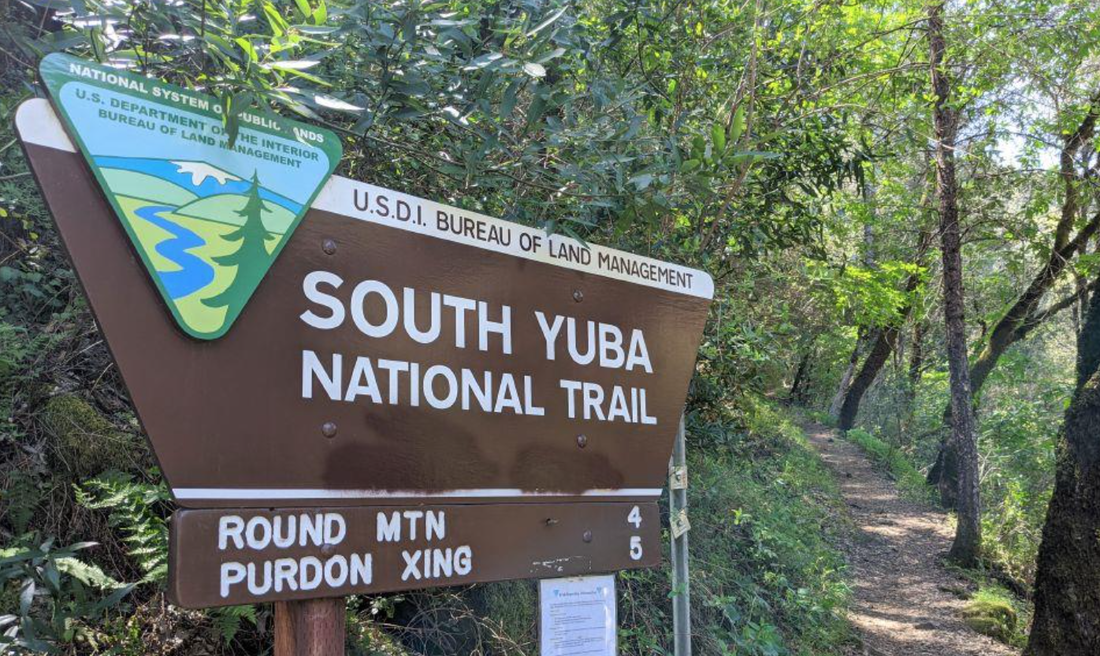
Over the years, Auburn has become the mecca of trail riding, running and ultra running. The city in the foothills is home to three of the biggest trail races in the world, attracting runners and riders from around the globe to come see, “The endurance capital of the world.”

It all started in 1955.
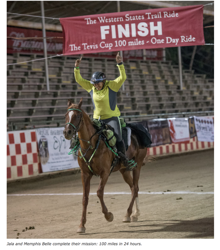
Wendell T. Robie sought to prove horses could endure 100 miles in one day. Robie and five other horsemen rode the Western States Trail from Tahoe City to Auburn. From there, the Western States Trail Foundation and Tevis Cup were born.


The Tevis Cup has been held annually since. Riders from around the world come to test the world-famous Western States Trail and try to complete the race in under 24 hours.
https://teviscup.org/


In 1974,
Tevis veteran Gordy Ainsleigh sought out on his own journey to prove he could complete the Tevis Cup course on foot. He crossed the finish line in Auburn 23 hours and 42 minutes later.

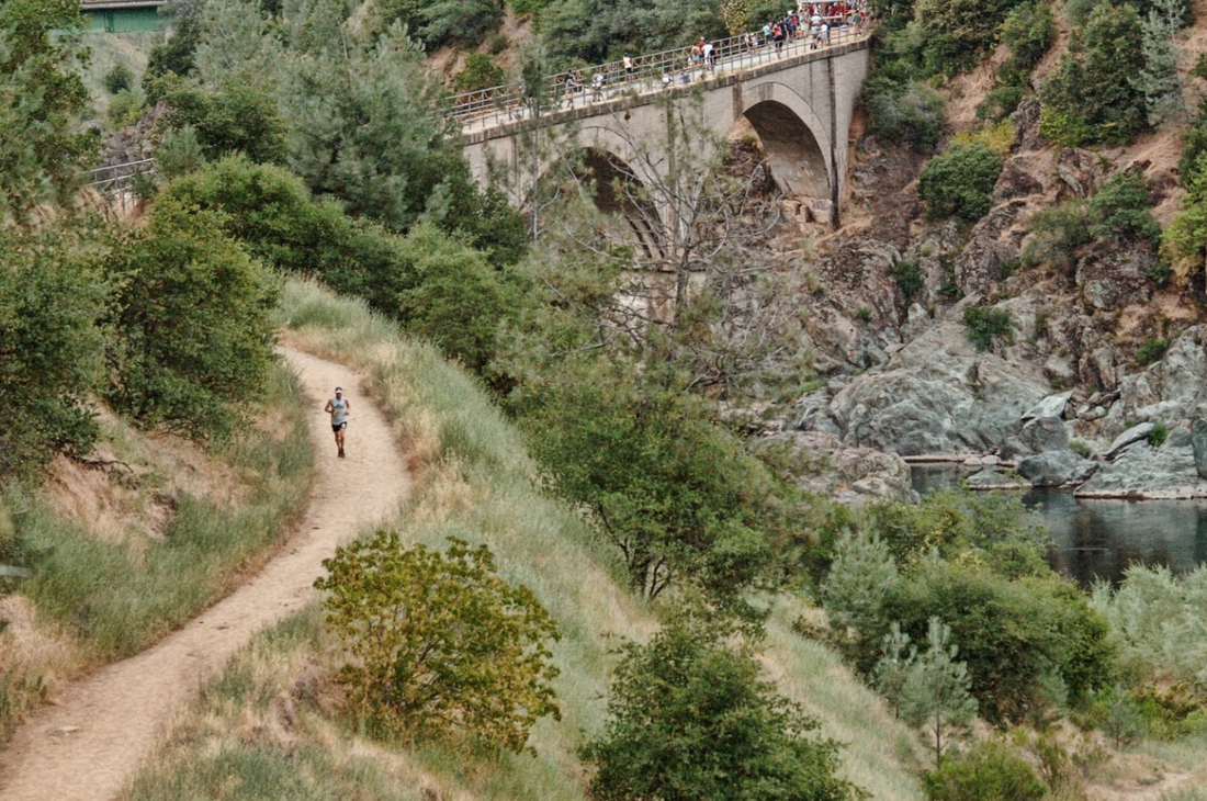
The run gained popularity in the 1970s, growing from one runner to 14 in 1977 and to 143 in 1979. Today, the Western States Endurance Run has become one of the elite trail running events and is the oldest ultra run in the world.

Runners locally and internationally try their luck at the trail every year at the race that begins at Tahoe’s Olympic Valley and ends at Placer High’s LeFebvre Stadium. Western States is an exclusive club, as runners have to either qualify for the race or be selected through a lottery.
https://www.wser.org/

In 2023 another run.
One qualifier begins in Auburn and has grown into one of the elite trail running events in its brief history. The Canyons Endurance Runs is a part of the UTMB World Series and one of four races in the U.S. that has a golden ticket to the Western States.

The 2022 edition took place April 23, when the 100k course records for men and women were broken. The Canyons features 100k, 50k and 25k events and is adding a 100-mile race in 2023.
https://www.facebook.com/runcanyons/

With three major trail events in the city, Auburn has earned its endurance capital title. Many runners in these events flock to Auburn for training, while the locals proudly talk about their advantage from running the race courses.

Auburn has become a home for endurance enthusiasts, by foot and hoof.

-by Jordan Georgeson


CLICK HERE to see the original article and photos in Gold Country Media.

Canyons Endurance Runs By UTMB® Adds 100-Mile Distance to Event to Western States Trail Beginning In 2023

4/24/2022

 
Picture
AUBURN, Calif. (April 21, 2022) /ENDURANCE SPORTSWIRE/ – The Canyons Endurance Runs™ by UTMB® announced today that beginning in 2023 the event will now offer a 100-mile distance. The new route will join the three current courses, that include a 100km, 50km, and 25km and will continue to cross some of the most scenic and challenging sections of the iconic Western States Trail. Registration for all distances at the 2023 Canyons Endurance Runs by UTMB, including the new 100-mile distance are now open and available at e3running.com/canyons. The 2023 Canyons Endurance Runs by UTMB is set to take place on April 28-29, 2023.

“We are thrilled to bring a 100-mile distance to Canyons Endurance Runs by UTMB,” said Chaz Sheya, Founder and Race Director for the Canyons Endurance Runs by UTMB®. “This new offering will provide a uniquely challenging test to our already stellar set of races while continuing to utilize portions of the Western States that have proven to be an unforgettable experience for all that toe the start line at Canyons. We can’t wait to push the envelope and see who steps up to the challenge of conquering 100-miles through the Sierras in 2023.”

The new 100-mile distance in 2023 will be a point-to-point uphill run from Auburn to the China Wall off of Foresthill Road. Testing the limits of the athletes, the route will experience some of the most scenic and challenging sections of the iconic Western States Trail and other classic trails with 24,000 feet of vertical gain.

It all starts in historic downtown Auburn, Calif. before crossing Ann Trason’s White Bridge, up to Robie Point and jumps on the historic Western States Trail for a fast descent to No Hands bridge. From No Hands bridge the race turns up the infamous K2 climb over to Cool, down the Coffer loop to the American River, up to Olmstead loop and back to Cool. Leaving Cool, runners will follow the Western States Trail across Hwy 49 to Quarry trail, up Brown’s Bar to Auburn Lake Trails (ALT), to American Canyon down to the Quarry trail and back to the Western States Trail to No Hands Bridge as they rejoin the 100km route. They will then take the Confluence Trail to Mammoth Bar to Drivers Flat and rejoin the Western States Trail along Cal Street to Foresthill, through Volcano Canyon to Michigan Bluff, down into Eldorado Canyon and up to Deadwood. From there, it will be down the steep Devil’s Thumb descent to Swinging Bridge and back up to Loop 6 where runners will be met with amazing views. As they enter the home stretch, runners will head back to Deadwood with a big drop into Eldorado Canyon before finishing with the final big climb to China Wall. The cutoff for the 100-mile distance will be 36 hours.

This year’s edition of the Canyons Endurance Runs by UTMB® is set to take place on April 23 and will start in the historic gold-rush town of Auburn, birthplace of mountain ultras in the northern California foothills of the Sierra Nevada range. Over 1,100 runners from more than 15 countries, regions, and territories are registered to embark on one of the three distances offered at the Canyons Endurance Runs by UTMB®.

The Canyons Endurance Runs by UTMB®, the second ever event in the 2022 UTMB® World Series the world’s leading trail running circuit, is a dual qualifier for the iconic UTMB® World Series Finals taking place in Chamonix, France, and is also a Western States 100 Golden Ticket race.

For more information about the Canyons Endurance Runs by UTMB® visit e3running.com/canyons. For more information about the 2022 UTMB® World Series visit utmb.world. 

Any hike is a great hike on the South Yuba Trail above Nevada City

4/22/2022

 
Picture
  
​The bridges of the South Yuba River State Park are historic, beautiful and of course cross the Yuba River in various locations, making any of them a great day hike.
(photos credit: Mary West)

One of my favorites is Edwards Crossing. The drive down the last mile or so might make you think you are driving down a rabbit hole into a wonderland, and maybe you are, as the trailhead is at the bottom, where the green pedestrian arch-truss bridge marks the start of this adventure. Installed in 1904, the bridge is a 114-foot stretch across the river.

Starting from Edwards Crossing, there is a gradual downhill walk for a 5-mile hike to Purdon Crossing, another bridge on the Yuba. As this is an out-and-back trail, you can stop anywhere along the way as your halfway point.

The boulders here are orange and pink, making it unique compared to the brilliant white granite in other areas on the Yuba. Sediment in the soil and mining have left their marks.

There are scenic trails beginning on both sides of the bridge and reasonable but limited parking at the bridge for hikers.

The South Yuba River Trail downstream from the bridge is on the south side of the river. Nice views will keep you company as far as you want to hike. Purdon Crossing will find you at the 5-mile mark, making for a 10-mile round trip.

DIRECTIONS
Take Interstate 80 east to Highway 49 toward Grass Valley. Take the left turn toward Downieville to stay on Highway 49. Take a right on Coyote Street. Turn right onto North Bloomfield Road/Bloomfield-Graniteville Road. You will enter the park and continue to Edwards Crossing on North Bloomfield at the river.

CLICK HERE to see the original article and photos on Gold Country Media.


Mary West is author of the book series Day Hiker – Gold Country Trail Guide I, II and III (2nd edition available on Amazon). The books are a collection of the Day Hiker columns where West shares her longtime love of the outdoors, favorite hikes in Northern California’s Gold Country and beyond. West was the recipient of the 2017 and 2019 CRAFT Award for Best Outdoor Column and the 2020 Craft Award for her second book in the series – Day Hiker Gold Country Trail Guide – by the Outdoor Writers of California. You can follow West on Facebook and Instagram.
Picture

Placer County Parks and Open Space welcomes Steve Gayfield as first Director

4/22/2022

 
Picture
Auburn, Calif.
Placer County this month welcomed Steve Gayfield as the first director of its new Department of Parks and Open Space. “Steve’s outstanding qualifications paired with his effective leadership style are precisely what our new Department of Parks and Open Space requires in order to advance the county’s parks and open space initiatives and all related efforts,” said Placer County Executive Officer Todd Leopold. “I have tremendous enthusiasm and confidence in Steve’s capacity to build on our many valued relationships and network of community partners including local and regional parks and recreation teams, public works and public utility districts.”

EXPERIENCE
Gayfield comes to the county with more than 30 years of experience working in parks and recreation; previously serving as executive director at Sulphur Parks and Recreation District in Louisiana and superintendent of parks and recreation for the City of Lancaster in Ohio.
“I am impressed with the forethought and planning going into what looks to be continued rapid growth in the county and the need for park services for the county residents,” said Gayfield. “Having worked in rapidly growing communities during my career I am familiar with the opportunities and challenges that such growth can bring to an organization.”

Gayfield also said that he’s looking forward to exploring Placer’s trail systems, highlighting his passion for mountain biking and trail running.

NEW PARKS AND OPEN SPACELast year, the Placer County Board of Supervisors approved an ordinance creating the new Department of Parks and Open Space, which will better position the county to accommodate its expanding park management responsibilities, increased service demands, and ensure the long-term financial viability of the county’s parks and open space operations.

The Department of Parks and Open Space manages and maintains over 35 parks and recreational facilities throughout the county, including Hidden Falls Regional Park, Loomis Basin community parks, Sterling Point equestrian staging area and trail, and Speedboat Beach, to name a few.
Learn more about the Department of Parks and Open Space at https://www.placer.ca.gov/parks.

CLICK HERE to read the complete article in Roseville Today.


Mountain bike group to establish 600-mile trail with the first 10 miles built just east of Truckee

4/15/2022

 
Picture
A Quincy-based nonprofit of trail builders is set to break ground on 10 miles of new trail just east of Truckee in North Lake Tahoe this spring. It’s the southernmost leg in a much larger project that aims to hook up 15 rural Sierra Nevada communities to a 600-mile network of multi-use, singletrack trail, a project called Connected Communities.

Connected Communities is a far-reaching $40 million vision. The group leading this plan, the Sierra Buttes Trail Stewardship (SBTS), is not to be underestimated. They have a proven track record of getting trails put down on the ground, trails that go on to become a stimulus for rural economies. Since 2003, SBTS has built 114 miles of new trail, maintained nearly 1,500 miles of existing trails, logged more than 100,000 volunteer hours. To date, the list of completed projects throughout the Lost Sierra numbers 121. 
The Sierra Buttes Trail Stewardship is also the group behind one of the most grueling and famous downhill mountain bike races in the country, the Downieville Classic, where hundreds of riders compete on a route that descends nearly 6,000 feet from the Sierra Crest to downtown Downieville, in 26.5 miles. 
Connected Communities is one of the Sierra Buttes Trail Stewardship’s most ambitious projects yet. It’s rooted in twin goals: creating more access to public lands and building a sustainable economy in the mountain communities that dot a forgotten, overlooked swath of Northern California. 

Historically, towns in the Lost Sierra were built on resource extraction, first gold mining and then logging and timber. In recent decades, as the logging industry faded, tourism in the Lost Sierra grew. Over the past few years, however, the Lost Sierra has been hit by forces of nature, both the pandemic and wildfires burning through the land. Last summer, the Dixie Fire razed an entire town on the Connected Communities map, Greenville, and went on to become the largest single-source wildfire in California history. In total, the Beckwourth Complex and Dixie fires burned about 272 miles of the proposed Lost Sierra Route, the centerpiece of the Connected Communities plan. 

Greenville took the heaviest loss in the Dixie Fire. Trails can help them rebuild and perhaps even come back stronger with a recreation-based economy, says Alex Terry, Connected Communities coordinator. Outdoor recreation is an $887 billion industry in the United States. Just building the trails mapped out with Connected Communities would create 150 jobs, according to SBTS.

“[Local residents] want trails and they want to rebuild a town that people want to go to and want to visit,” Terry said, talking of conversations he’s had with local residents. 
“It’s still epic up here,” Terry said. “It’s still beautiful. Even though the largest single wildfire in U.S. history came through, it’s still an incredible place to live, an incredible place to come and recreate.”

As SBTS has proven that trails attract people from across the globe — bringing travelers who will then support local businesses. They’ve also shown how trails can become a centerpiece of local life, giving residents a means to engage with the surrounding public land. In a survey of 1,179 local residents and visitors to the Lost Sierra, SBTS found that the vast majority of respondents, some 94%, want more trails near their town centers. And about 88% of respondents said they’d volunteer to build and maintain new trails. 

“In phase one of this project, we went out and did surveys and got public input,” said Mark Pecotich, development and marketing lead for SBTS. “Had people draw on maps, you know, where they wanted the trail to be in each town. We were very active with each of these communities to make sure the focus was about bringing people into town. And then, when they’re around town and they want to go out, the community members, they can have these recreational zones and they can go out and have different experiences, whether it’s motorized or not.”

The Lost Sierra is home to an already established through-route, the Pacific Crest Trail (PCT). But in many ways, Connected Communities seeks to offer a completely opposite experience from the Pacific Crest Trail.  Unlike the Pacific Crest Trail, the Lost Sierra Route would be a motorized, multi-use singletrack, open to mountain biking, e-biking, motorcycling.

The Pacific Crest Trail is a point-to-point trail, built mostly for through-hikers. It’s non-motorized, non-mechanized, meaning motorcycles and mountain biking are both prohibited on the Pacific Crest Trail. The PCT is designed to immerse hikers and equestrians in a wilderness environment, far from towns and civilization. 

Instead of a single line running north to south, the Connected Communities trails will be a network sprawling across some 600 miles, from Truckee and Reno to Sierraville, Portola, Downieville, Quincy, Greenville, Chester, Susanville — with more towns between. 

The entire point is to showcase what makes each one of those towns unique and bring people to main streets where gorgeous, quiet forests meet small town markets and restaurants.

In a survey of 1,179 local residents and visitors to the Lost Sierra, Sierra Buttes Trail Stewardship found that the vast majority of respondents, some 94%, want more trails near their town centers.

Courtesy of Sierra Buttes Trail StewardshipThe biggest thread, where the whole plan comes together, is the Lost Sierra Route.

The Connected Communities map also features non-motorized multi-use trails that will branch off the Lost Sierra Route, giving hikers, mountain bikers and equestrians quieter, motorcycle-free options, too. 

“We want to be able to let people choose where they want to travel and then bring people into the downtowns of those locations,” said Terry.
The whole idea is to build a trail for everyone, Pecotich said.

Connected Communities is one of the Sierra Buttes Trail Stewardship’s most ambitious projects yet.
Courtesy of Sierra Buttes Trail StewardshipThe East Zone project in Truckee is located near Prosser, Boca and Stampede reservoirs, close to Hirschdale and the California-Nevada state line. The northern end of the East Zone trail will link up with the Lost Sierra Route. In addition to building new trails, the Lost Sierra Route intends to use historic and existing routes, including old mining paths, railroad grades and logging flumes, according to SBTS. Some 71 miles of trail are “shovel ready,” and while the SBTS works on the first 10-mile segment this summer near Boca Reservoir in Truckee, the Tahoe National Forest will be building another 9-mile segment in the same zone. They’re hoping to make substantial progress on building the trail this summer.

Connected Communities received grant funding to make the progress it has. SBTS is seeking out more philanthropy and individual donations to support the project. SBTS is also looking ahead to bringing back the first of its signature events — huge fundraisers for trail building — since the pandemic. 

Its biggest event, the Downieville Classic, was canceled in 2020 and 2021. The 2022 Downieville Classic has been postponed but is on the calendar for 2023. However, the Lost and Found Gravel Festival is coming back this year, the first weekend of June in Portola. The Lost and Found is a gravel bike ride — participants can choose between 35-, 60- and 100-mile routes. But it’s also a festival that brings families and communities together around a shared love for bikes. The event is also a chance to bring visitors back to Portola after the Dixie Fire charred the surrounding forests.

“We’re optimistic we’re going to have a great turnout. There’s been a lot of buzz in the gravel community about the event coming back,” said Pecotich. “They’re still trying to not only recover from the COVID experience, but also these massive wildfires which took out large swaths of forest.”

CLICK HERE to see the original article and photos in the San Francisco Chronicle.
​

Mary West: Exploring Canyon View Preserve

4/7/2022

 
Picture
I first visited the Canyon View Preserve the day Placer Land Trust celebrated its grand opening to the public. Volunteers, media and local dignitaries gathered to get a first look at the native plants, trees, grasses and wildflowers that call the area home. Placer Land Trust acquired the land at the end of 2003 and has since worked to restore and preserve the property.

I was thrilled to have a new trail so close to town with a new fantastic view of the Foresthill Bridge and the Sierra Nevada Mountains. Since that day more improvements have been made including benches and picnic tables. More restoration projects are planned for the area including connecting this trail to the Auburn State Recreation Area.

The 50-acre property, now in trust for public access, contains a 1.25-mile loop at the rim of the canyon off Lincoln Way in North Auburn. Take the Bowman Road exit off Interstate 80 and park in the park and ride under the Cal Star helicopters. The trail runs along the guardrail across Lincoln Way from the parking lot and down into the preserve.

With the heat of summer, you may be looking for a shorter hike, close to home. This is it. This trail is also a great location to get in a quick run or walk the dog. There is plenty of shade and a bench along the way, but you will get plenty of vitamin D as there are exposed areas along the route, so bring water, wear sunblock if you need it, and a hat and glasses if that’s your style.

There is some elevation change so sturdy shoes will be your friend. The Harrigan Loop adds the ¼ mile. A wooden footbridge crosses Sierra Canyon Creek at the top and is a nice spot to pause.

If you are short on time, but want to stretch your legs, need a spot for lunch, or just want to enjoy a relaxing view, check out Canyon View Preserve Trail.

Community support is the Placer Land Trust’s greatest asset. Members and partners support all aspects of the organization through their passion, involvement and contributions; without them, Placer Land Trust could not operate. Learn more about Placer Land Trust at Placerlandtrust.org.

Mary West is author of the book series Day Hiker – Gold Country Trail Guide I, II and III (2nd edition Available on Amazon). The books are a collection of the Day Hiker columns where West shares her longtime love of the outdoors, favorite hikes in Northern California’s Gold Country and beyond. West was the recipient of the 2017 and 2019 CRAFT Award for Best Outdoor Column and the 2020 Craft Award for her second book in the series-Day Hiker Gold Country Trail Guide by the Outdoor

CLICK HERE to see the original article and more photos in The Union newspaper.

    Trail News

    Visit this page for all of the latest Trail News that affects our area.

    Archives

    June 2025
    February 2025
    August 2024
    September 2023
    June 2023
    March 2023
    February 2023
    January 2023
    November 2022
    October 2022
    September 2022
    August 2022
    July 2022
    June 2022
    April 2022
    March 2022
    January 2022
    November 2021
    October 2021
    August 2021
    July 2021
    June 2021
    May 2021
    April 2021
    March 2021
    February 2021
    January 2021
    December 2020
    November 2020
    October 2020
    September 2020
    August 2020
    July 2020
    June 2020
    May 2020
    April 2020
    March 2020
    February 2020
    January 2020
    December 2019
    November 2019
    October 2019
    September 2019
    August 2019
    July 2019
    June 2019
    May 2019
    April 2019
    March 2019
    February 2019
    January 2019
    December 2018
    November 2018
    October 2018
    September 2018
    August 2018
    July 2018
    June 2018
    May 2018
    April 2018
    March 2018
    February 2018
    January 2018
    December 2017
    November 2017
    October 2017
    September 2017
    August 2017
    July 2017
    June 2017
    May 2017
    April 2017
    March 2017
    February 2017
    January 2017
    December 2016
    November 2016
    October 2016
    September 2016
    August 2016
    July 2016
    June 2016
    May 2016
    April 2016
    March 2016
    February 2016
    January 2016
    December 2015
    November 2015
    October 2015
    September 2015
    August 2015

    Categories

    All

    RSS Feed

Home
Contact
 Mother Lode Trails is YOUR local volunteer-run trail information and resource website. Here you can find
up-to-the minute information on trail alerts, links and trail news for Placer,  Yuba, and Nevada counties.
Mother Lode Trails is trademarked.