MOTHER LODE TRAILS
  • Home
  • About
  • Contact
  • Volunteer
  • Links
    • Law Enforcement Emergency
    • Federal, State, County Districts Parks & Trails
    • Running Clubs
    • Equestrian Clubs
    • Mt. Bike Clubs
    • Hiking Clubs
    • Trail Advocacy Organizations
    • Phone Numbers State & Federal Parks, Trails & Lands
    • Where to Eat on the Trails
  • News
  • Alerts

Martis Valley 10.2 mile paved trail gains momentum

1/28/2021

 
Picture
The anticipated cost of the trail from the Martis Creek Lake Recreation Area to Northstar Drive is $8 million. In addition to local sources, the project will be funded by federal and state grant programs.

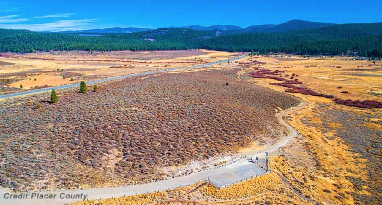
The Martis Valley Trail project in North Lake Tahoe reached significant funding and multi-agency environmental review milestones this month as part of a trail system envisioned for the region. The 10.2-mile paved pathway will connect the Town of Truckee through Martis Valley and Northstar Village and up to the Brockway Summit. The project is a collaborative effort with the Northstar Community Service District. The Resort at Northstar has also provided needed trail easements.

In the first of several milestones, the U.S. Army Corps of Engineers on Jan. 11 completed their environmental review approving the section of the project that runs through their property, the Martis Creek Lake Recreation Area.

Washoe Tribe members were consulted to understand their history and concerns. With continuing input from the Tribe, the project will incorporate protections of cultural resources and convey the story of the Tribe’s rich history in the valley.

In a related development, the Placer County Board of Supervisors on Jan. 12 approved the allocation of $750,000 in local county park development fees and transient occupancy taxes to complete the necessary funding for the project.

RESORT TRIANGLE TRAIL
The project will ultimately become part of the Resort Triangle Trail, which, when complete, will connect the communities of Kings Beach, Tahoe City, Olympic Valley, Truckee, Martis Valley and Northstar in a great big loop trail.
“The signing of the federal environmental document by the Corps of Engineers completes a process that has been years in the works and clears the way for construction of an important segment of the Martis Valley Trail,” said Placer County Parks Administrator Andy Fisher. “It took the cooperation of many agencies and stakeholders to get us to this point.”

Placer County District 5 Supervisor Cindy Gustafson took time in the Jan. 12 Board of Supervisors meeting to thank some of the key people who were instrumental in the project including U.S. Rep. Tom McClintock’s office, the Sacramento District of the U.S. Army Corps of Engineers and Northstar Community Services District General Manager Mike Staudenmayer.

A LEAD ROLE
Northstar Community Service District has taken a lead role in construction of over a mile of the trail that can be seen today from Highway 267 driving across Martis Valley from Truckee headed toward Tahoe. The trail is already well used for recreation, but with the clearance and funding in place to connect the trail all the way to Northstar Drive, it will provide alternative transportation options as well as recreation.

ANTICIPATED COST
The anticipated cost of the trail from the Martis Creek Lake Recreation Area to Northstar Drive is $8 million. In addition to local sources, the project will be funded by federal and state grant programs.
Construction on the trail segments that will complete the connection between the Town of Truckee and Northstar Drive is slated to begin later this year.​

CLICK HERE to see the original article and photos in the Roseville Today newspaper.


Mary West: Exploring Magnolia Ranch Trailhead

1/22/2021

 
Picture
Highway 49 trailheads provide several South Fork American River access points in El Dorado County. Each has its own character and makes for a nice hike in all seasons.

Magnolia Ranch Trailhead between the towns of Pilot Hill and Coloma is one option. This popular equestrian trail network has caught on with mountain bikers and hikers alike. Offering primarily two trails from the parking lot, an upper trail, Gerle Loop, at an easy 2.5 miles and the South Fork American River Trail just slightly longer. Gerle Loop accesses Hastings Creek and Cronan Ranch if you want to extend these hikes. Be prepared for direct sun in the beginning, but oak trees provide shade as you make your way. Wildflowers in the spring are an added bonus.

Gerle Loop is a popular trail running path that runs along mid-slope and is a bit less trafficked. The more popular of the two trails, the South Fork American River Trail, offers several opportunities to access the river, some with sand beaches.

South Fork American River Trail at 2.6 miles can also be taken as a loop from Magnolia Trailhead. If you head south on the trail from the parking lot, it takes you directly to the Greenwood Creek put-in Beach. From the beach you can follow the trail along the river. The trail takes you back up hill and to a wide-open trail uphill that meets back up to Gerle Loop and returns you to the parking lot.

Watching kayakers and rafters drift by, the sun setting behind the trees on the hill across the river, listening to the water lap at the shore, skipping rocks, this is a great place to hang out anytime of year.
Magnolia Ranch Trailhead is about five miles north of Coloma on Highway 49 or 14 miles south of Auburn.

Mary West is author of the book series Day Hiker – Gold Country Trail Guide I, II and III (Available on Amazon). The books are a collection of the Day Hiker columns where West shares her longtime love of the outdoors, favorite hikes in Northern California’s Gold Country and beyond. West was the recipient of the 2017 and 2019 CRAFT Award for Best Outdoor Column and the 2020 Craft Award for her second book in the series-Day Hiker Gold Country Trail Guide by the Outdoor Writers of California. You can follow West on Facebook and Instagram.

CLICK HERE to see the original article and more photos in The Union newspaper.

Sky Mountain in Tahoe National Forest purchased for 6th grade science camp

1/22/2021

 
Picture
The San Joaquin County Office of Education (SJCOE) has acquired the Sky Mountain Outdoor Education Center.
​
​Sky Mountain is 28 miles west of Truckee at an approximate elevation range of 5,500-6,000 feet. The parcel encompasses many scenic lakes in the high elevation mountains of the Sierra.  It is surrounded by National Forest System lands managed by the Tahoe National Forest and private property. The parcel is accessible via Lake Valley Road, which is accessed from the Yuba Gap exit off of Interstate 80.

It will serve as science camp for sixth graders in the Manteca and Ripon unified school districts as well as other students in the county and throughout the San Joaquin Valley starting in the 2011-2012 school year.
Situated at the top of the North Fork of the American River in the Sierra in Tahoe National Forest in Placer County, the property will become the new home for Science Camp for San Joaquin Valley students.
Sky Mountain includes cabins, a gymnasium, lodge, and other facilities surrounded by acres of forest alongside a pristine mountain lake. The 62.68-acre parcel was donated by the Pacific Gas & Electric to SJCOE.  Preexisting infrastructure, capital assets, and $2.5 million to support code compliance and infrastructure reinforcement were donated by the Pacific Forest and Watershed Lands Stewardship Council.  In 2016, the SJCOE applied to become a grantee of the property through the Stewardship Council, which oversees more than 140,000 acres of watershed lands owned by PG&E to ensure they are used to benefit the residents of California.

Sky Mountain is located 45 miles northeast of Auburn and 28 miles west of Truckee at an approximate elevation range of 5,500-6,000 feet. The parcel encompasses many scenic lakes in the high elevation mountains of the Sierra.  It is surrounded by National Forest System lands managed by the Tahoe National Forest and private property. The parcel is accessible via Lake Valley Road, which is accessed from the Yuba Gap exit off of Interstate 80.

As part of the transaction, the SJCOE will work closely with the Wildlife Heritage Foundation (WHF), a non-profit organization dedicated to protecting and enhancing wildlife habitat and connecting Californians to the outdoors. As the holder of the conservation easement, the WHF will oversee the protection of the ecological habitat and ensure the appropriate use of this natural open space.

Sky Mountain will be the new location of Science Camp, as the SJCOE outdoor education program has been known to students for over 60 years who have come to the Santa Cruz Mountains through a contract with the YMCA at Camp Jones Gulch. 

“We are grateful for the long-standing partnership we have had with the YMCA and Camp Jones Gulch. The memories and traditions created there are shared by generations of our county’s residents,” San Joaquin County Superintendent of Schools James Mousalimas said. “It is difficult to close this chapter in our history, but Sky Mountain allows us more opportunities to provide outdoor education experiences to students year-round We are excited to offer Science Camp at Sky Mountain beginning in the 2021-2022 school year as we develop the next generation of innovative, ecologically literate community stewards and leaders. The possibilities are endless.”

By owning Sky Mountain, the SJCOE will have the flexibility to offer year-round programs to students of all ages and provide other opportunities for educators and community partners.

Peter Ottesen, the former director of science camp for 35 years, believes the new site at Sky Mountain will allow the award-winning resident outdoor school to flourish in the years to come. 
"The opportunity to acquire Sky Mountain, complete with modern living spaces and food service facilities and a travel time not encumbered by dense traffic, provides assurances that the popular program will continue well into the future,” said Ottesen.  “The change of sites couldn't happen at a better time."

Since 1976, the Sky Mountain property has been leased from PG&E for a camp and conference center.  During the planning phase of this new project, the SJCOE is working on renovating the preexisting facilities and designing a new curriculum specific to the unique ecosystem that aligns with the Next Generation Science Standards and makes connections with California’s Environmental Principles and Concepts. 

“Students will learn about different ecosystems and how watersheds are connected.  Snow is connected to rivers, rivers are connected to the Delta in San Joaquin County, and the Delta is connected to the ocean,” SJCOE STEM Director Annie Cunial said.  “And year-round activities will range from canoeing and archery in the summer to snowshoeing in the winter,” she said.  “These activities will enhance students’ experiences as they learn about the history of the land from the Native American tribes to early California explorers, as well as flora, hydroelectric dams, conifer forests, wildlife, industries, careers, and more.”

Due to the COVID-19 pandemic, which has changed how field trips can be offered, programming information for the new center will not be available until the 2021-2022 school year.  The SJCOE will provide an update once programming begins. 

CLICK HERE to see the original article in the Manteca Bulletin Newspaper.

Self guided hikes with the Wild and Scenic Film Festival

1/19/2021

 
Picture
During the festival, normally held at Grass Valley and Nevada City, there are many events other than just films. This year, in addition to a virtual festival, there are local hikes with "help." These self-guided excursions are to help you keep the “Wild” in Wild & Scenic. While these hikes are for Nevada County, CA we encourage you to go get outside and explore wherever you may be!

1. Scenic Highway 49 from Nevada City to Sierra City
  • Heading toward Sierra City on Highway 49, you will cross the stunning, emerald south fork of the Yuba, a state-designated Wild & Scenic river canyon.
  • Continuing on to cross the middle fork at Oregon Creek Day-Use Area.
  • As you slowly climb in elevation, Highway 49 catches up to the north fork of the Yuba River, where you’ll find plenty of small parks and pull-offs along the way with breathtaking views of the river canyon where you can be sure to stay socially distant.

2. Hiking for Good presents Connect with Nature on the Hirschman Trail 
  • Just a short one-mile walk from downtown Nevada City, Hirschman Trail is an easy to moderate forested adventure found in the Deer Creek Watershed.
  • Now teeming with wildlife, the trail’s showpiece is Hirschman Pond, created by hydraulic mining during the Gold Rush.
CLICK HERE for the PDF file guide


3. Explore Tahoe National Forest
  • If you head up Highway 20, just past Harmony Ridge you’ll enter the Tahoe National Forest.
  • The Pioneer Trail runs parallel along Highway 20 through a beautiful canopy of trees. Look for pull outs on the left side of the highway all the way to Conservation Camp Road. There’s plenty of flat space to stretch your legs and find solitude in the forest. Continue upward to find parks with 180-degree scenic views of the Sierra Nevadas.

4. It’s All Newt to Me: A Self-Guided Orientation to Amphibians of the Yuba
  • While most people spend their hikes facing forward, look down for a change and discover the world of amphibians.
  • Explore the Yuba Watershed from the eyes of frogs and salamanders on easy trails near Nevada City.
  • This self-guided excursion is supplemented by materials from avid herper Shannon Hedge to teach you about the wonders of these animals at your feet.
Click Here for the PDF guide

​5. Importance of Nisenan Voice in Our Community
The Deer Creek Tribute Trail is a great opportunity for community education and outreach. The Nisenan Cultural Reclamation Corridor along Deer Creek will connect two points of the Tribute Trail. Wolf Creek in Grass Valley also offers educational opportunities through interpretive signage. Nevada City Rancheria Tribal Spokesperson Shelly Covert will discuss the visibility the trails have brought to the Tribe as well as the critical importance of connecting people with nature.

CLICK HERE to see the Wild and Scenic Film Festival Excursions webpage.

Exploring Hidden Falls with Mary West

1/8/2021

 
Picture
Now is the time to check out the trails that are either too crowded or too hot later in spring and summer. Hidden Falls Regional Park in Placer County is not a spur of the moment trip. Hidden Falls requires a reservation you can get online.

The green meadows and flowing creeks make this regional park a gem in Placer County in winter. The trails are well maintained, the bridges and decks are handsome and sturdy. The variety of trails will keep you going back again and again.

You may have heard parking is difficult. Yes, if you go after 10 a.m. the parking lot fills up quickly. I suggest going early or late. On my last trek, I went in the afternoon and I was able to park in the middle of the main lot and the light for photography was amazing.

I would encourage you to choose a hike while the weather is still mild. I have hiked the area several times and in the heat of summer. The grasses are dry and much of the trail is exposed to direct sun, making for a hot day. The payoff is finding a nice swimming hole along Coon creek.

This is a heavily trafficked area. The easy to moderate trails make it great for families and those who are looking for a shorter outing. If you get beyond the inner trails that lead to the falls, such as River Otter Loop, you leave the crowds and have more of the trail to yourself.

These are multi-use trails so expect to share the path with mountain bikes and horses. And don’t be surprised if you see grazing cattle or sheep too.

To get to Hidden Falls from Interstate 80, head north on Highway 49 toward Grass Valley. Turn left on Palm Ave to Mount Vernon to 7587 Mears Place, Auburn. If you are coming from Grass Valley you could take Joeger or Atwood Roads to Mount Vernon to Mears Place.

With 1,200-acres to wander, follow a route that looks like fun and enjoy.

Mary West is author of the book series Day Hiker – Gold Country Trail Guide I, II and III (Available on Amazon). The books are a collection of the Day Hiker columns where West shares her longtime love of the outdoors, favorite hikes in Northern California’s Gold Country and beyond. West was the recipient of the 2017 and 2019 CRAFT Award for Best Outdoor Column and the 2020 Craft Award for her second book in the series-Day Hiker Gold Country Trail Guide by the Outdoor Writers of California. You can follow West on Facebook and Instagram.

CLICK HERE to see complete article and more photos in The Union newspaper.
​


    Trail News

    Visit this page for all of the latest Trail News that affects our area.

    Archives

    June 2025
    February 2025
    August 2024
    September 2023
    June 2023
    March 2023
    February 2023
    January 2023
    November 2022
    October 2022
    September 2022
    August 2022
    July 2022
    June 2022
    April 2022
    March 2022
    January 2022
    November 2021
    October 2021
    August 2021
    July 2021
    June 2021
    May 2021
    April 2021
    March 2021
    February 2021
    January 2021
    December 2020
    November 2020
    October 2020
    September 2020
    August 2020
    July 2020
    June 2020
    May 2020
    April 2020
    March 2020
    February 2020
    January 2020
    December 2019
    November 2019
    October 2019
    September 2019
    August 2019
    July 2019
    June 2019
    May 2019
    April 2019
    March 2019
    February 2019
    January 2019
    December 2018
    November 2018
    October 2018
    September 2018
    August 2018
    July 2018
    June 2018
    May 2018
    April 2018
    March 2018
    February 2018
    January 2018
    December 2017
    November 2017
    October 2017
    September 2017
    August 2017
    July 2017
    June 2017
    May 2017
    April 2017
    March 2017
    February 2017
    January 2017
    December 2016
    November 2016
    October 2016
    September 2016
    August 2016
    July 2016
    June 2016
    May 2016
    April 2016
    March 2016
    February 2016
    January 2016
    December 2015
    November 2015
    October 2015
    September 2015
    August 2015

    Categories

    All

    RSS Feed

Home
Contact
 Mother Lode Trails is YOUR local volunteer-run trail information and resource website. Here you can find
up-to-the minute information on trail alerts, links and trail news for Placer,  Yuba, and Nevada counties.
Mother Lode Trails is trademarked.