MOTHER LODE TRAILS
  • Home
  • About
  • Contact
  • Volunteer
  • Links
    • Law Enforcement Emergency
    • Federal, State, County Districts Parks & Trails
    • Running Clubs
    • Equestrian Clubs
    • Mt. Bike Clubs
    • Hiking Clubs
    • Trail Advocacy Organizations
    • Phone Numbers State & Federal Parks, Trails & Lands
    • Where to Eat on the Trails
  • News
  • Alerts

Cool hike: Donner Summit to Olympic Valley

8/27/2020

 
Picture
From the Truckee Donner Land Trust Newsletter
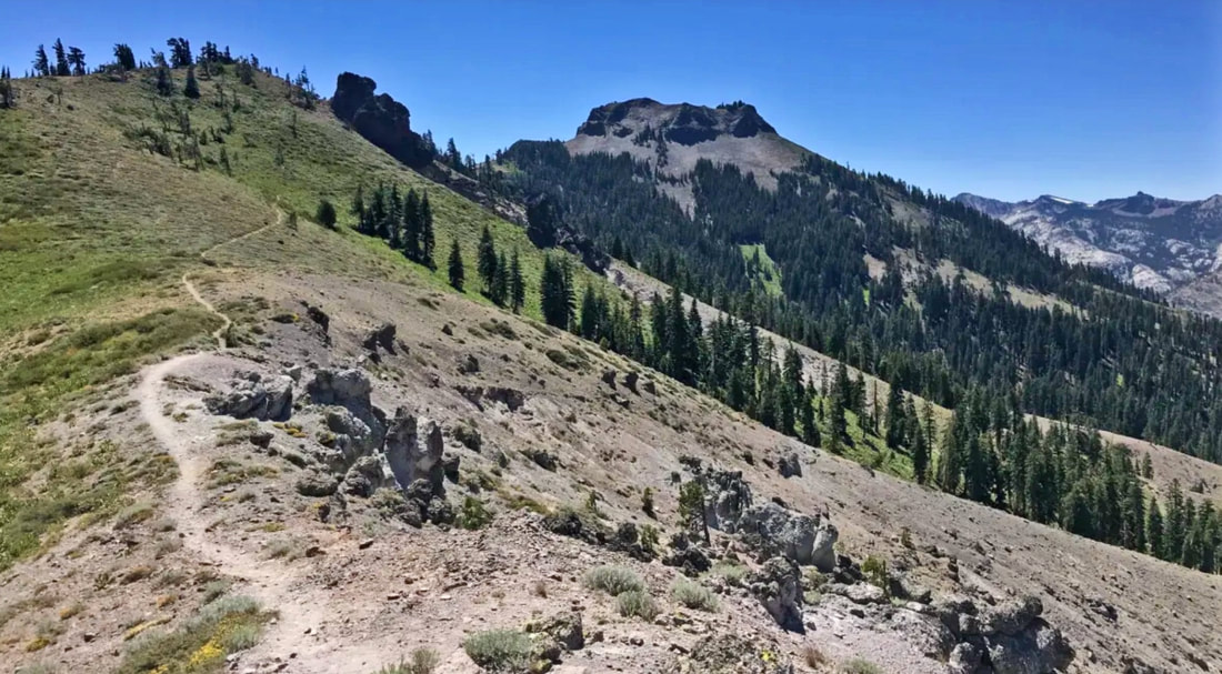
One of the great things about the Truckee Donner Region is when it gets hot, we can escape the heat by heading to higher elevations - Royal Gorge, the Donner Lake Rim Trail, the Mt. Lola Trail above Perazzo Meadows, and the Sierra Crest. This month’s hike is a true classic, the Pacific Crest Trail (PCT) from Donner Summit to Olympic Valley. Sixteen miles in length, it’s a favorite for those seeking a long day out in nature, and many of its iconic views were protected by the Truckee Donner Land Trust over the years.


This hike is a point-to-point journey, beginning, at the Donner Summit trailhead of the PCT just behind the Summit Haus. This trailhead is receiving major upgrades from our friends at the Donner Summit Association, including signage, bathrooms and picnic tables. The trail starts by climbing up beautiful-hand-built steps up the slopes of Donner Peak, Sugar Bowl Ski Resort and Mt. Judah. Ground-hugging flowers last late into the summer here. As the trail gets higher and the Judah loop splits to the left, hikers will enjoy a mountain hemlock forest. Hemlocks seem more suited to a children’s book with their twisted trunks and tops that often bow over to the ground.

Views of Van Norden Meadow open to the west, with Razorback ridge and Rowton Peak (last month’s hike of the month) looming in the distance. This landscape was protected by the Land trust in 2012.
As the trail gains the Sierra Crest, the view to the west is of Schallenberger Ridge above Donner Lake and Coldstream Canyon tucked in just behind it - two areas where the Land Trust got its start in buying open space three decades ago. For most of the remainder of the route, the trail never strays far from the Sierra Crest. Elevations above 8,000 feet, combined with cooling breezes, provide a great escape from the valley heat. The route passes the distinctive round top of Anderson Peak and the 8900-foot Tinker’s knob, both familiar landmarks from Town.

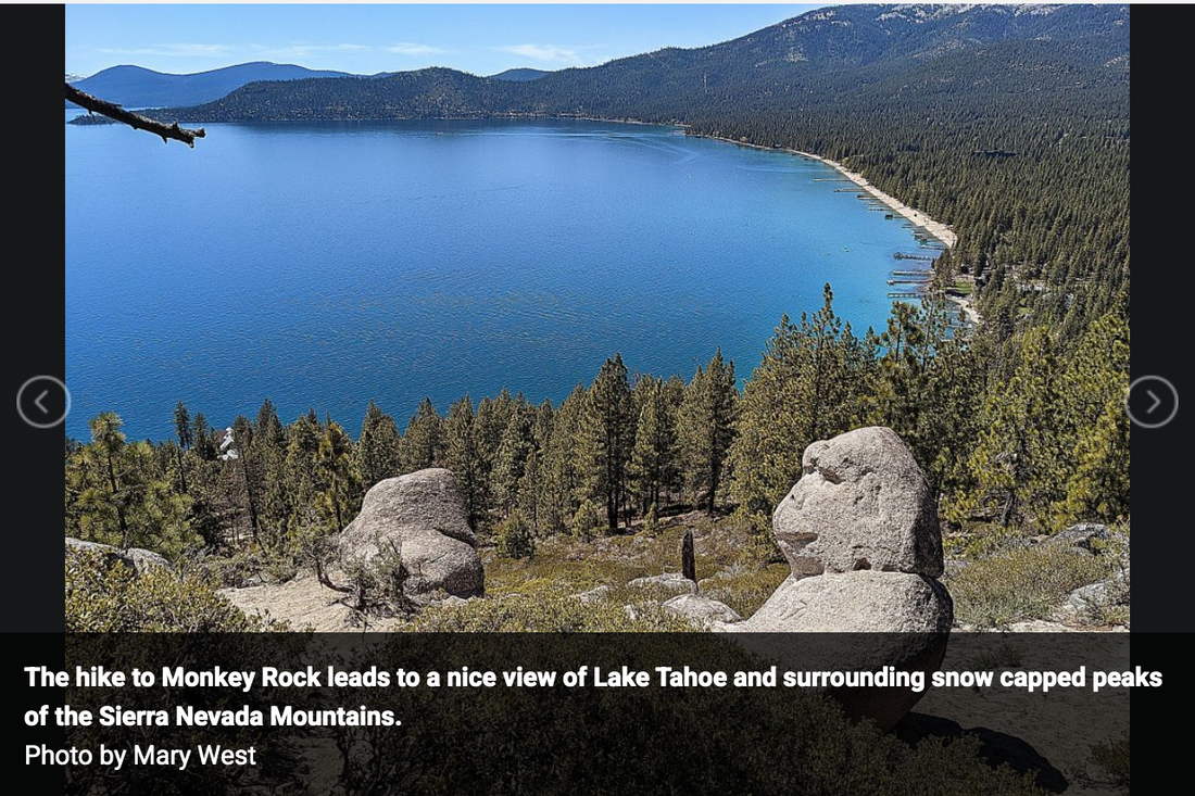
Dramatic views of the Granite Chief Wilderness and Royal Gorge of the American River - some 5,000 feet below, fill the south and western skylines. The hike leaves the Pacific Crest Trail with a left turn near diminutive Mountain Meadows Lake, before descending the Granite Chief Trail near the top of the Shirley Canyon as it heads into Olympic Valley below.

We recommend Hiking Project for maps and directions.

Remember, no bicycles are allowed on the Pacific Crest Trail.

To read the complete article and get photos, CLICK HERE for the Truckee-Donner Land Trust News.


California, U.S. Forest Service, Establish Shared Long-Term Strategy (MOU) to Manage Forests and Rangelands

8/16/2020

 
Picture
Agreement will improve coordination to reduce wildfire risks on federal and state lands as well as increase recreation. Funding included in the federal Great American Outdoors Act. 
SACRAMENTO Aug. 12, 2020— In a key step to improve stewardship of California’s forests, the Newsom Administration and the U.S. Forest Service today announced a new joint state-federal initiative (MOU) to reduce wildfire risks, restore watersheds, protect habitat and biological diversity, and help the state meet its climate objectives.
The Agreement for Shared Stewardship of California’s Forest and Rangelands includes a commitment by the federal government to match California’s goal of reducing wildfire risks on 500,000 acres of forest land per year. To protect public safety and ecology, experts agree that at least one million acres of California forest and wildlands must be treated annually across jurisdictions.

A historical transition toward unnaturally dense forests, a century of fire suppression and climate change resulting in warmer, hotter and drier conditions have left the majority of California’s forestland highly vulnerable to catastrophic wildfire and in need of active, science-based management. Since the federal government owns nearly 58 percent of California’s 33 million acres of forestlands, while the state owns 3 percent, joint state-federal management is crucial to California’s overall forest health and wildfire resilience.

Improved coordination also is key since nearly half of the state dollars invested in fuels management in recent years was spent on federal land.

“Wildfires don’t stop at jurisdictional boundaries. As we respond to wildfires in real-time this summer, improving coordination between the major stewards of California’s forested land will help us protect communities and restore forest health across California,” Governor Gavin Newsom said. “We are grateful to secure the U.S. Forest Service’s commitment to help us more effectively address the scale of California’s current wildfire crisis.”
“Collaboration between state and federal agencies on issues of forest health and resiliency is critical,” said U.S. Forest Service Chief Vicki Christiansen. “The Forest Service is fortunate to collaborate on restoration projects across the state and share science and research to address issues to help care for the land and serve people. We are excited to expand our partnership with California to enhance our collaboration though this Shared Stewardship agreement with California.”
The Shared Stewardship Agreement builds on existing coordination between state and federal agencies, and outlines six core principles and nine specific actions that will drive improved state-federal collaboration:
  • Prioritize public safety;
  • Use science to guide forest management;
  • Coordinate land management across jurisdictions;
  • Increase the scale and pace of forest management projects;
  • Remove barriers that slow project approvals; and
  • Work closely with all stakeholders, including tribal communities, environmental groups, academia and timber companies.
Specifically, through this agreement California and the U.S. Forest Service commit to execute the following activities together:
  • Treat one million acres of forest and wildland annually to reduce risk of catastrophic wildfire (building on the state’s existing 500,000-acre annual commitment);
  • Develop a shared 20-year plan for forest health and vegetation treatment that establishes and coordinates priority projects;
  • Expand use of ecologically sustainable techniques for vegetation treatments such as prescribed fire;
  • Increase pace and scale of forest management by improving ecologically sustainable timber harvest in California and grow jobs by tackling structural obstacles, such as workforce and equipment shortfalls and lack of access to capital;
  • Prioritize co-benefits of forest health such as carbon sequestration, biodiversity, healthy watersheds and stable rural economies;
  • Recycle forest byproducts to avoid burning slash piles;
  • Improve sustainable recreation opportunities;
  • Enable resilient, fire-adapted communities; and
  • Share data and continue to invest in science.
The Great American Outdoors Act, signed into law on August 4, will provide critical funding for the Forest Service’s work in California.
 CLICK HERE to see original press release from Gov. Newsom's office.

Mary West: Exploring Monkey Rock above Lake Tahoe

8/14/2020

 
Picture
The famed Monkey Rock that overlooks Lake Tahoe from East Lake is off Tunnel Road in the Spooner Backcountry, part of Lake Tahoe Nevada State Parks. The hike to Monkey Rock (more like a gorilla, which is not a monkey but a great ape. We will let that go) leads to a nice view of Lake Tahoe and surrounding snow capped peaks of the Sierra Nevada Mountains.

I went hiking with my oldest son Canyon, his brilliant girlfriend Emily, and our faithful K9 Stella the wonder dog to Monkey Rock in late spring. We decided to take the longer — but we think — more scenic Highway 50 approach on the way up. At Sand Harbor look for the Bullwheel parking lot in front of the Tunnel Creek Cafe. There is no parking at the trailhead.

The steady climb is made easier by the ever-changing views of beautiful blue Lake Tahoe, the towering pines and bright granite boulders. Your hike begins from the parking lot and up behind the Tunnel Creek Cafe on Tunnel Creek Road. There is a $2 fee to hike the trails. An iron ranger with envelopes is up the trail a piece.

Once on Tunnel Creek Road it is all uphill. At the intersection you make the left with a steep uphill climb. You hike nearly 500 feet up on decomposed granite and sand. For this reason, I call this short hike moderate. The climb up is not so bad but coming down can be slippery. Wear sturdy shoes and if you are at all worried take your trekking poles. There is a longer route that spreads the hike over a greater distance and is less steep. You can find this alternative just a bit further up the main trail.

The steady climb is made easier by the ever-changing views of beautiful blue Lake Tahoe, the towering pines and bright granite boulders.

This is a popular trail. Once on top expect to wait your turn in the jumble of rocks that overlooks the lake and of course the co-star of the show, the gorilla shaped rock that sits taking in the view with you.
This in and out hike is maybe three miles total. You will not find signs declaring Monkey Rock. You must know what you are looking for. Other trails continue beyond Monkey Rock to Marlette Flume Trail, Tahoe Rim Trail and Twin Lakes.

The alternate route is up Interstate 80 to CA-267S in Truckee. Take NV-28E to Tahoe Blvd to Tunnel Creek Blvd in Incline Village.

Mary West is author of the book series Day Hiker – Gold Country Trail Guides (Available on Amazon). The books are a collection of the Day Hiker columns where West shares her longtime love of the outdoors, and favorite hikes in Northern California’s Gold Country and beyond. West was the recipient of the 2018 and 2019 CRAFT Award for Best Outdoor Column by the Outdoor Writers of California. You can follow West on Facebook and Instagram.


​

New bike patrol on the American River Parkway bike trails

8/6/2020

 
Picture
This past February, the Sacramento County Board of Supervisors voted to authorize the establishment of the American River Bike Patrol to watch over the bike trails on the American River Parkway. The volunteer Bike Patrol, organized by the National Ski Patrol (NSP), has recruited and trained members and began patrolling the trails in July. 
Photo credit: American River Parkway Bike Patrol

The patrol’s 55 volunteer members were trained by the NSP in first-aid, CPR and basic bicycle repair. Regional Parks Rangers helped to train volunteers on expected trail etiquette. All volunteers are required to wear a volunteer bicycle patrol uniform, distinguishing themselves from regular users of the trail. NSP coordinates bicycle trail volunteer schedules with Regional Parks.

“We are excited for these volunteers to hit the trails to help teach trail users about trail safety and etiquette,” said Liz Bellas, Director of Regional Parks. “We have seen an increase in new trail users this year and these new users don’t always know proper trail etiquette, which can be dangerous for other trail users. The Bike Patrol members will be great educational resources.” 

 “We are delighted to be part of the Parkway team and our agenda focuses on safety; safe cycling, safe walking and family enjoyment on the trail,” said Jim Che​ng, Bike Patrol Representative.

Members of the Bike Patrol will act as trail ambassadors providing directional advice, equipment assistance, safety insights and bike safety programs, assistance with events and first-aid services. 
---

Similar volunteer trail programs for equestrian mounted patrols have existed in this area for decades, but this is the first for a bike patrol. Current equestrian volunteer patrols are: Folsom Lake SRA Mounted Trail Patrol, Gold Country Trails Council (Tahoe National Forest) Mounted Trail Patrol, Sac Valley Equestrian Patrol, Auburn SRA Mounted Trail Patrol, and American River Parkway Equestrian Patrol. If you are interested in volunteering for any of these programs, visit the VOLUNTEER tab on the Mother Lode Trails web page.

CLICK HERE for original article in the Sacramento County News.

    Trail News

    Visit this page for all of the latest Trail News that affects our area.

    Archives

    February 2025
    August 2024
    September 2023
    June 2023
    March 2023
    February 2023
    January 2023
    November 2022
    October 2022
    September 2022
    August 2022
    July 2022
    June 2022
    April 2022
    March 2022
    January 2022
    November 2021
    October 2021
    August 2021
    July 2021
    June 2021
    May 2021
    April 2021
    March 2021
    February 2021
    January 2021
    December 2020
    November 2020
    October 2020
    September 2020
    August 2020
    July 2020
    June 2020
    May 2020
    April 2020
    March 2020
    February 2020
    January 2020
    December 2019
    November 2019
    October 2019
    September 2019
    August 2019
    July 2019
    June 2019
    May 2019
    April 2019
    March 2019
    February 2019
    January 2019
    December 2018
    November 2018
    October 2018
    September 2018
    August 2018
    July 2018
    June 2018
    May 2018
    April 2018
    March 2018
    February 2018
    January 2018
    December 2017
    November 2017
    October 2017
    September 2017
    August 2017
    July 2017
    June 2017
    May 2017
    April 2017
    March 2017
    February 2017
    January 2017
    December 2016
    November 2016
    October 2016
    September 2016
    August 2016
    July 2016
    June 2016
    May 2016
    April 2016
    March 2016
    February 2016
    January 2016
    December 2015
    November 2015
    October 2015
    September 2015
    August 2015

    Categories

    All

    RSS Feed

Home
Contact
 Mother Lode Trails is YOUR local volunteer-run trail information and resource website. Here you can find
up-to-the minute information on trail alerts, links and trail news for Placer,  Yuba, and Nevada counties.
Mother Lode Trails is trademarked.