MOTHER LODE TRAILS
  • Home
  • About
  • Contact
  • Volunteer
  • Links
    • Law Enforcement Emergency
    • Federal, State, County Districts Parks & Trails
    • Running Clubs
    • Equestrian Clubs
    • Mt. Bike Clubs
    • Hiking Clubs
    • Trail Advocacy Organizations
    • Phone Numbers State & Federal Parks, Trails & Lands
    • Where to Eat on the Trails
  • News
  • Alerts

Bucket list trails for summer wildflowers in the Sierra

7/30/2017

 
Picture
When you walk the paths of Summit Valley, bring your hand lends and follow the simple keys in the "Wildflowers of Nevada and Placer Counties." (See the previous News article, "Wildflowers of Nevada and Placer Counties - new edition!") The variety of plants blooming everywhere will challenge you to examine the petals and leaves of Meadow Lupine, Alpine Aster, Soft Arnica, Mountain Hollyhock, and Western Ladies Tresses. Wildflowers adapted to the high elevation habitat may start growing before snow melt, grow fast, flower and set seed very rapidly. Winter comes early and the flowering period may be only one month.
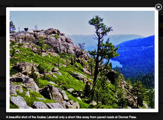
AZALEA LAKE TRAIL
Just a short hike from teh paved roads at Donner Pass, this four mile section of the Pacific Crest Trail features views of Donner Lake to the east and distant snow capped ridges. Ancient Sierra Junipers and bonzai conifers grow among the massive granite boulders on the slops of Donner Summit. The rock gardens along the trail are fun to explore and to watch bees and butterflies visit the bring pink Mountain Pride Penstemon and bright yellow Sulfur Buckwheat.

LONEY MEADOW
In the Grouse Ridge area, this is a favorite destination for summer field trips led by the California Native Plant Society. The 1.5 miles mostly level loop around the meadow's edge passes through moist and dry habitats where wildflowers thrive. Orange flowered Alpine Lilies, Giant Red Indian Paintbrush, Bog Orchids, Dogbane, Mountain Pennyroyal and purple Camas Lilies are some of the favorites.

SAGEHEN CREEK
This popular trail seven miles north of Truckee will introduce you to the unique flora of the eastern slope of the Sierra Nevada where it meets the Great Basin. Several species of Sagebrush, Wood Rose, Western Peony, Hairy Paintbrush and Marsh Marigold make this trail interesting all the way to Stampede Reservoir.

To see the photos and article written by Karen Callahan in the Union Newspaper, purchase the Friday, July 28, 2017 edition, section B, page 1

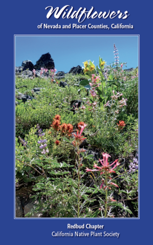
To purchase the brand new edition of "Wildflowers of Nevada and Placer Counties" from the California Native Plant Society CLICK HERE.

Wildflowers of Nevada and Placer Counties: new edition!

7/30/2017

 
Picture
The wait is over.
A decade after the release of their first edition, the Redbud Chapter of the California Native Plant Society has just released an updated version of the popular guidebook, "Wildflowers of Nevada and Placer Counties, California."
With 600 color photos and descriptions of over 500 species of wildflowers, the 442-page book features a new plant key with icons for each family for easy identification; illustrations by Ames Gilbert showing flower parts, flower shapes and leaf structures; maps and 20 destinations for casual hikers and avid botanist to view some of the best local displays of wildflowers in the Sierra Nevada and foothills.
"Our goal with our books is to provide the general public and amateur botanists with a simplified resource to identify local wildflowers," said Bill Wilson, researcher and coordinator of the editorial committee for the book.
The eight-member editorial committee spent two years writing, researching and photographing plants to produce the newest guide. No stranger to hard work and passionate about their subject, the team spent four years producing the companion volume, "Trees and Shrubs of Nevada and Placer Counties" and eight years on the original wildflower book.
With elevations that range from the Sacramento Valley floor to the crest of the Sierra Nevada mountain range, Nevada and Placer counties are botanically diverse. Upward of 38 percent of all plants known to grow in California can be found in this region.
"This astonishing diversity proved to be a delight to our team of botanists and they couldn't stop. By the time the original wildflower book was published in 2007, eight years had elapsed and the small spiral-bound book morphed into a full-fledged guidebook," said active California Native Plant Society member Julie Becker.
In the decade since the first printing, the terminology in the original wildflower book had become out-of-date. So the team got to work, revising their copy.
"The last two decades have seen massive use of DNA to take a closer look at how plants are related. That means a lot of wildflowers got moved from one group to another," said Wilson.
The new book is flying off the shelves and available at 30 retail outlets including: Nevada City Stores such as The Earth Store, HAALo, Harmony Books, J.J. Jackson, Prospector's Nursery and the visitor centers at South Yuba River State Park at Bridgeport, and Donner Memorial State Park in Truckee.
The Redbud Chapter of California Native Plant Society is one of 35 chapters in the state and locally has about 200 members with a passion for plants. The primary mission of California Native Plant Society is to conserve native plants and their natural environments. Each year, members share and learn propagation techniques and raise hundreds of plants for the fall plant sale on Oct. 14 at the historic North Star House. They also lead field trips and study ethnobotany, exploring the ways indigenous cultures traditionally used and cultivated plants.
Sometimes the group even becomes advocates for the natural world. In April, members conducted a botanical survey of native plants at the proposed site of Nevada Irrigation District's Centennial Dam and became vocal in their support for preserving wild places, submitting extensive comments in opposition of the project.
A lecture series called "Passionate about Native Plants" is held every other month. Folks interested in attending may want to check out the next scheduled series on Aug. 23, a talk on how mycorrhizal fungi feed the forest.
To buy the book, learn more about how to get involved as a volunteer or find out about upcoming hikes, visit: http://www.redbud-cnps.org
To purchase this new edition, GO HERE.
To see the original article in The Union newspaper by Laura Petersen, CLICK HERE.


No justice for Sacramento running legend hit by cyclist on the American River Parkway

7/28/2017

 
Picture
--Opinion by Marcos Bretón, [email protected]
The verdict is in: There will be no justice for Bill Finkbeiner, the Sacramento running legend who got creamed by a cyclist on the American River Parkway last month.

Finkbeiner, a veteran of 17 Western States 100-Mile endurance runs, was walking on a trail when he was hit from behind by a man on a bike. Finkbeiner’s nose and orbital bones were broken and his front teeth snapped off when he slammed face first into concrete pavement. For a while, his face was an open wound, and his left thumb had to be surgically repaired.
The man who did all this to Finkbeiner on June 13 is very lucky. He hit Finkbeiner and basically fled the scene, but he will not be prosecuted by the Sacramento County District Attorney’s office for a hit-and-run.
Why? Because local prosecutors don’t believe the California Vehicle Code is clear on hit-and-run guidelines when the incident involves a bike and occurs on a levee road, as Finkbeiner’s did near the Campus Commons Golf Course. Maybe if Finkbeiner had been hit on a city street – where the law is clearer on the responsibilities of the parties involved – prosecutors could have brought charges.
There were other factors at play as well, according to Steve Grippi, chief deputy prosecutor for Sacramento County. By his own admission, Finkbeiner was walking on the right side of the levee road, which is known to be the side where cyclists ride. And, by his own admission, Finkbeiner thought the incident was not a result of malice – but an accident.
These elements made prevailing in a hit-and-run case appear unlikely, Grippi said. Not convinced they could prosecute any lesser charge, Grippi’s office informed Finkbeiner this past week that they would not prosecute the man who had upended his life, and then pedaled away without saying a word, according to witnesses.
Grippi said investigators for his office did find and interview the man responsible for Finkbeiner’s grievous injuries. He claimed it was an accident. Grippi would not share the name of this person because he said his office is not in the practice of releasing the names of people they choose not prosecute.
But Grippi did say this: “On basic decency and accountability, I would put Mr. Finkbeiner at the highest end of the scale. I wouldn’t necessarily agree that the bicyclist is on the same end of the spectrum.”
In the end, Grippi said: “A lack of a moral compass is not a crime.”
Finkbeiner, 61, is remarkably upbeat considering the severity of his injuries. He said he bears no ill will toward the man who injured him. He’s been surrounded by friends who love and support him. A GoFundMe account for him – www.gofundme.com/bill-finkbeiners-recovery-fund – has taken in more than $46,000 and has helped to offset the income he has lost by not being able to work as a self-employed commercial landscaper.
He will recover, and he will run again. And what of the man who injured Finkbeiner and left him a bloody mess on the American River Parkway? He’s lucky that in this instance lacking a moral compass isn’t a punishable offense. Because he’s clearly guilty of that.

To see the original blog at the Sacramento Bee Newspaper, CLICK HERE.
Related story in the Sacramento Bee Newspaper, "He ran every day for the past 37 years. A senseless act of violence just ended his streak." CLICK HERE.
Picture

BLM Report: $50 million generated by quiet recreation in northwest California

7/26/2017

 
Picture
A report released Thursday states outdoor recreation on Bureau lands has generated tens of millions of dollars and support hundreds of jobs in nearby communities.

The hikers, bicyclists, hunters, horseback riders, fishermen and other outdoor enthusiasts who use Bureau of Land Management lands each year in northwest California are generating tens of millions of dollars and supporting hundreds of jobs in local communities, according to an ECONorthwest report released Thursday.

Analyzing local economic and visitor data from 2015 — the most recent data available at the time — at the federal bureau’s Arcata and Redding field offices, the Pew Charitable Trusts-funded report states “quiet,” or nonmotorized, recreational activities on bureau lands have generated more than $41 million and supported hundreds of local jobs.

“Those are direct purchases, people stopping at the store to buy groceries, rent equipment or hire guides,” ECONorthwest Senior Economic Consultant Kristin Lee said. “Then that spending circulates in the economy and multiplies as those dollars become paychecks for people, business income for shop owners and income for suppliers of goods and services. The economic output associated with all that spending was approximately $50 million.”

Pacific Outfitters co-owner Aaron Ostrom said in a Thursday statement the report highlights that a recreation economy is “critical” for local businesses. “It’s why we now have three stores in two counties ... and business has never been better,” Ostrom wrote.

The report was released as the bureau’s Arcata and Redding field offices are working to update a master plan that sets guidelines on how they manage their nearly 400,000 acres of land.

The plan, formally known as the Northwest California Integrated Resource Management Plan, addresses everything from recreational activities, wildlife management, livestock grazing, mining, creation of special recreational areas such as the Samoa Dunes, and protection of endangered species to name a few, according to the bureau’s Arcata Field Office Planning Environmental Coordinator David Fuller.

“It sets the course for how the lands are going to be managed in the broad, big picture sense,” Fuller said. As recreational uses are a major focus of this master plan, Fuller said the Pew report provides new insight that will help inform the bureau’s decision-making. Lee stated that Pew Charitable Trusts commissioned the northwestern California report knowing the plan update process was occurring.

Out-of-area visitors to the bureau’s northwest California lands generated the most money for local communities in 2015, spending about $29 million of the $41 million in direct spending recorded that year, the report states.

Recreational users also supported 570 jobs and generated $27 million in wages, salaries and benefits for people whose livelihood is connected with these recreational uses, according to the report. “These recreational tourists eat in our restaurants, stay in our hotels, and shop our local downtown areas,” Redwood Region Economic Development Commission Executive Director Gregg Foster said in a statement Thursday. “I’ve been in banking and small business development for over 20 years and I have seen directly how these visitors contribute significantly to our local economies. Continuing to manage these lands with recreation is key to the health of our local businesses.”

This data does not include visits to the Headwaters Forest Reserve and the King Range National Conservation Areas in Humboldt County as those two regions are managed under separate plans, Fuller said.

Northwest California was one of several regions the Oregon-based economic consulting firm ECONorthwest was commissioned to review by the Pew Charitable Trusts. ECONorthwest released similar reports for areas in Utah and Colorado this year. The report for northwestern California bureau lands demonstrated that these quiet forms of recreation were the dominant use by visitors over their motorized counterparts, such as those who drive quads and snowmobiles.

For the bureau’s Arcata and Redding field offices, 81 percent of the 1.29 million recreational visits to their lands in 2015 were for nonmotorized activities, according to the report. This is higher than the average of the 11 Western states, which was about 62 percent, Lee said. Based on the public input, Fuller said that the bureau could begin to prioritize certain lands for recreational uses as part of their resource management plan update. These management plans are updated every 20 to 25 years, Fuller said. The plans for the Arcata and Redding field offices were last updated in the early 1990s.

The bureau has held several public meetings at the start of the year to gauge the public’s interest on how they want their land to be used. The bureau is now working to draft several options based on this input. Fuller said these management options will likely be released to the public this winter. The bureau plans to have a final environmental review and plan in place in 2019, Fuller said.

The full report can be found online at www.pewtrusts.org/~/media/assets/2017/07/californiaquietrecreportjuly2017final.pdf

--By Will Houston, Eureka Times-Standard
Photo by David Fuller
07/20/17, 9:40 PM PDT
More information on the Northwest California Integrated Resource Management Plan can be found at go.usa.gov/xkJYd
To see the original article and photo in the Times-Standard News CLICK HERE.

Bikes in federal Wilderness Areas: a solution?

7/24/2017

 
Picture
From the Sierra Sun newspaper, serving Truckee, Tahoe City, Kings Beach and Incline Village:
A new Act could allow for mountain biking in federal Wilderness Areas.
Mountain biking has grown in popularity during the past several decades. Likewise, the acreage of federally designated wilderness has also increased significantly. Bikes are not allowed in designated wilderness areas, and some mountain biking enthusiasts (but what feels to be the minority) are beginning to feel shut out.

This emerging topic of conversation that has been getting more play in the mainstream news is the issue of whether to allow mountain biking in federally designated wilderness areas. Various mountain biking advocacy groups have led this charge, and have even raised money to fund a lobbyist in Washington, D.C., to work on this issue.

WHY THE FUSS?
A Google search will quickly suck you into the vortex of this debate. Mountain bikers are feeling left out of decisions to designate increasing acreage as wilderness. In some cases, biking trails that have been used for years have been closed after an area was given wilderness status.

That may seem like deja vu — but that is precisely what the Bundy brothers were taking issue with as they occupied the Malheur National Wildlife Refuge last year — protesting as their decades-long grazing practices were progressively limited by the Bureau of Land Management in order to protect the natural environment. Many mountain bikers are genuinely conflicted — should they support wilderness preservationists or side with mining, timber, and business interests, who also want wilderness access?

Perhaps it should come as no surprise to learn that the leading politicians of Utah who have sponsored a bill to allow bikes in wilderness are the same politicians who also introduced legislation to sell off America's public lands. The political leaders of Utah have been coming under much heat lately for their stance on public lands, and have since lost the massive Outdoor Retailer Show to Denver, Colo.

Groups that have formed to challenge the motorized and mechanized aspects of wilderness face a mountainous hurdle, for several reasons. Most salient, the Wilderness Act of 1964 states that there shall be no "form of mechanical transport" in wilderness. Arguments that bikes are, like hikers, muscle-powered conveyances, and that while bikes are mechanical, so are oar locks (which are allowed in wilderness) are a tough sell for most people.

In addition, the traditional spiritual values of the wilderness experience — solitude, natural challenges, humility — are not descriptors one typically employs while enumerating the joys of mountain biking, such as exhilaration, adrenalin-rush and other adjectives that explain why mountain bikers wear all that protective gear.

Still, mountain bikers love wild places, and they are a rapidly growing, vocal group. A win-win way forward is exemplified in The Continental Divide Wilderness and Recreation Act, sponsored by Eagle County's congressman in the U.S. House of Representatives, Jared Polis. Now in congressional committee, the act was drafted by hundreds of collaborating stakeholders, including the Vail Valley Mountain Bike Association, and the Summit Fat Tire Society.

SOMETHING FOR EVERYONE

The wilderness part of the act would designate 40,000 additional acres of land as traditional wilderness (no bikes), and the recreation part of the act would designate 15,000 acres of White River National Forest as "Special Management" zones, where mountain biking would be allowed. This demonstrated a successful partnership between often misunderstood forces, transitioning into important co-stakeholders for the success of the introduction of this bill at a federal level.

This type of collaboration should serve as the gold standard for new potential wilderness addition. There are many other threats to our public lands and open spaces; creating an unnecessary wall of resentment between two very ideologically aligned groups who share conservationist values would be counterproductive.

Tim Drescher is a member of the Friends of Eagles Nest Wilderness, an all-volunteer organization committed to the health and preservation of three Wilderness areas in Eagle and Summit counties: Eagles Nest, Holy Cross and Ptarmigan. Visit http://www.fenw.org for more information.

Tim Drescher | Special to the Daily
Above photo by Jessie Klehfoth and Scott Bellow, below.

CLICK HERE to see the original article and photos in the Sierra Sun newspaper.


Picture

Tahoe trail network takes shape

7/8/2017

 
Picture
Bit by bit, a trail is taking shape at Lake Tahoe that will eventually connect Tahoe City, Kings Beach and Truckee. When finished, the trail will begin at the Truckee-Tahoe Airport in Martis Valley and continue to the Village at Northstar. Then the trail will head up to the ridge where it will connect to other regional trails.

The Northstar Community Services District recently received $250,000 in hotel tax money to begin the next phase, about 2 miles of the Martis Valley Trail. The Martis Valley Trail is part of a planned 62-mile trail network that Peter Kraatz, assistant director for Placer County’s public works and facilities department, calls the “resort triangle.”

Of the 62 miles, half has been completed. The remaining half includes the Martis Valley Trail along the northeastern leg of the resort triangle, in addition to a few unfinished gaps along the north shore of Lake Tahoe and Truckee River.
The Martis Valley segment of the trail will cover about 8 miles of trail which will ultimately connect Northstar Village, Truckee and Lake Tahoe. These 8 miles have been divided into four 2-mile segments. Transient occupancy tax funding will deliver the first 2 miles of the trail from the north end of Martis Valley to the south end.

The purpose of the trail is mainly recreation, but can also accommodate bicycle commuters, Kraatz said.
“A trail system like this will give people another option to either commute to work or to do something between those two communities without using their car,” he said.

There is already an informal dirt path that the paved trail will follow but, as Kraatz pointed out, bicycles are unable to use an unpaved trail. Right now, traveling between Truckee and Tahoe requires bicycles to take the highway. The paved trail will be 10 feet wide, so hikers and bicyclists can all share the path between communities.

Transient occupancy tax is charged to travelers in the United States when they rent accommodations in a hotel, inn, tourist house, motel, or any other temporary lodgings for fewer than 30 days. One million dollars in TOT taxes already have been allocated for the construction of the trail, and the Placer County Parks Division has contributed $2.5 million.

The rest of the funding has not been secured, said Kraatz. “We still need another $8.5 million to complete the whole 8 miles. That funding will probably come from additional TOT and federal and state grants that we will apply for over time that are specific to recreation facilities.”

The next milestone for the trail is for the 2-mile segment to be completed in 2018. Hikers and commuters can expect the trail to be finished in 2022.
--By Karen Marks, [email protected]
Photo credit, North Fork Associates

To see the complete article and pictures in the Sacramento Bee newspaper, CLICK HERE.

    Trail News

    Visit this page for all of the latest Trail News that affects our area.

    Archives

    February 2025
    August 2024
    September 2023
    June 2023
    March 2023
    February 2023
    January 2023
    November 2022
    October 2022
    September 2022
    August 2022
    July 2022
    June 2022
    April 2022
    March 2022
    January 2022
    November 2021
    October 2021
    August 2021
    July 2021
    June 2021
    May 2021
    April 2021
    March 2021
    February 2021
    January 2021
    December 2020
    November 2020
    October 2020
    September 2020
    August 2020
    July 2020
    June 2020
    May 2020
    April 2020
    March 2020
    February 2020
    January 2020
    December 2019
    November 2019
    October 2019
    September 2019
    August 2019
    July 2019
    June 2019
    May 2019
    April 2019
    March 2019
    February 2019
    January 2019
    December 2018
    November 2018
    October 2018
    September 2018
    August 2018
    July 2018
    June 2018
    May 2018
    April 2018
    March 2018
    February 2018
    January 2018
    December 2017
    November 2017
    October 2017
    September 2017
    August 2017
    July 2017
    June 2017
    May 2017
    April 2017
    March 2017
    February 2017
    January 2017
    December 2016
    November 2016
    October 2016
    September 2016
    August 2016
    July 2016
    June 2016
    May 2016
    April 2016
    March 2016
    February 2016
    January 2016
    December 2015
    November 2015
    October 2015
    September 2015
    August 2015

    Categories

    All

    RSS Feed

Home
Contact
 Mother Lode Trails is YOUR local volunteer-run trail information and resource website. Here you can find
up-to-the minute information on trail alerts, links and trail news for Placer,  Yuba, and Nevada counties.
Mother Lode Trails is trademarked.