The end result, though, would mean a multi-use path from the Sutter Buttes through the heart of two cities and out to the Yuba River, Harris said.
Fifty years ago, the state transformed Sacramento by creating an interconnected highway system through the capital region. Now it’s time to do the same for bicycles and pedestrians, a group of regional planners says.
The Sacramento Area Council of Governments, representing city and county leaders in the six-county area, is asking people this week to submit their bike travel interests in an online survey that will serve as a bike and walk signpost for future trail planning.
The survey can be found at www.sacog.org/pod/get-connected.
“I think we could be the cycling capital of the United States,” said James Corless, executive director at SACOG, which covers Sacramento, Yolo, El Dorado, Placer, Yuba and Sutter counties. “We have a great climate. A lot of our region is flat.
“The demand for safe spaces to walk and bike for families and kids is not going away. It’s a way to connect low-income people to jobs. It’s a public health issue.”
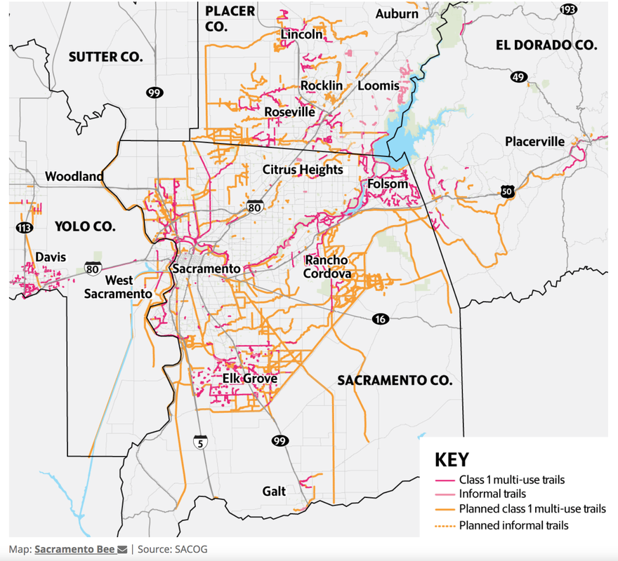
The region already has a disconnected patchwork of off-street biking corridors that will serve as a starting point. It includes the 32-mile American River Bike Trail, the off-street bike trail systems in Folsom and Davis. There are also levee-top and creekside trails around the region and the blustery Yolo Causeway bike path that connects Davis with West Sacramento.
The city of Sacramento is planning to turn a four-mile stretch of an old railroad corridor into an off-street bike lane running from Meadowview to William Land Park, and Citrus Heights and Orangevale are scheduled to be connected via a three-mile bike and walking trail running on an electrical power corridor next to Arcade and Cripple creeks.
SACOG plans this summer to design a better-linked system that fills in the blanks and will make it easier and safer to travel on bikes - both for long and short rides.
Planners say they estimate the region would need 300 more miles of trail to augment the existing 450 miles now in existence.
The system could include something as dramatic as turning an old rail line into a multi-use bike, hike and even horse trail between El Dorado Hills and Placerville. Or a bikeway over the American River next to the Capital City Freeway.
The plan would make it easier for cities to win funding for more localized bike routes, such as one in Yuba City and Marysville that would take advantage of an unused Union Pacific rail corridor to link residential areas, shopping districts, parks, medical facilities, and offices.
Yuba City Councilman Shon Harris, a member of the SACOG board, said the regional plan would help his city tap bike planning expertise and funding opportunities for what would be a defining project for the two cities - but an expensive one. The cities and counties likely would have to negotiate with UP to buy the right of way, and would have to figure out a way to get cyclists safely across Highways 20 and 99.
The end result, though, would mean a multi-use path from the Sutter Buttes through the heart of two cities and out to the Yuba River, Harris said.
“It will take a lot of planning and money,” Harris said. “But it’s a win-win. We just need to get the pieces in order.”
SACOG is conducting a public survey on its website asking people to tell them where they live, and what places they would like to travel to via bike or walking, if they felt the route were safe. The survey is set to close on Friday.
“Where does the public want to go?” Corless said.
SACOG provides basic information on its website about the process of designing the project. SACOG officials estimate that the region may have has as much as one-quarter of a full system of trails already in place.
The concept has been in the planning for several years. SACOG officials say the timing is good to come up with a design for a comprehensive system. The COVID-19 pandemic has caused bike sales to increase, and the Biden administration has recently proposed a major new infrastructure funding concept that would include more money for biking systems.
One key goal is to link under-resourced and lower-income neighborhoods to jobs, shopping and recreation. That is one of the goals in particular of Sacramento’s planned Del Rio Bike Trail in south Sacramento.
A SACOG analysis found that about 48% of the region lives within half mile of a trail of any length. Only 25% of trails are located within disadvantaged communities in the region, while 37% of the region’s residents live in disadvantaged communities.
Another issue that needs tackling is how to bring cyclists safely into densely packed job areas, like downtowns. The city of Sacramento has begun experimenting with closing some midtown streets to through car traffic and is discussing closing off other streets or sections of streets to create a direct bike path into the central business district.
CLICK HERE to see the original article and images in the Sacramento Bee newspaper.
Fifty years ago, the state transformed Sacramento by creating an interconnected highway system through the capital region. Now it’s time to do the same for bicycles and pedestrians, a group of regional planners says.
The Sacramento Area Council of Governments, representing city and county leaders in the six-county area, is asking people this week to submit their bike travel interests in an online survey that will serve as a bike and walk signpost for future trail planning.
The survey can be found at www.sacog.org/pod/get-connected.
“I think we could be the cycling capital of the United States,” said James Corless, executive director at SACOG, which covers Sacramento, Yolo, El Dorado, Placer, Yuba and Sutter counties. “We have a great climate. A lot of our region is flat.
“The demand for safe spaces to walk and bike for families and kids is not going away. It’s a way to connect low-income people to jobs. It’s a public health issue.”
The region already has a disconnected patchwork of off-street biking corridors that will serve as a starting point. It includes the 32-mile American River Bike Trail, the off-street bike trail systems in Folsom and Davis. There are also levee-top and creekside trails around the region and the blustery Yolo Causeway bike path that connects Davis with West Sacramento.
The city of Sacramento is planning to turn a four-mile stretch of an old railroad corridor into an off-street bike lane running from Meadowview to William Land Park, and Citrus Heights and Orangevale are scheduled to be connected via a three-mile bike and walking trail running on an electrical power corridor next to Arcade and Cripple creeks.
SACOG plans this summer to design a better-linked system that fills in the blanks and will make it easier and safer to travel on bikes - both for long and short rides.
Planners say they estimate the region would need 300 more miles of trail to augment the existing 450 miles now in existence.
The system could include something as dramatic as turning an old rail line into a multi-use bike, hike and even horse trail between El Dorado Hills and Placerville. Or a bikeway over the American River next to the Capital City Freeway.
The plan would make it easier for cities to win funding for more localized bike routes, such as one in Yuba City and Marysville that would take advantage of an unused Union Pacific rail corridor to link residential areas, shopping districts, parks, medical facilities, and offices.
Yuba City Councilman Shon Harris, a member of the SACOG board, said the regional plan would help his city tap bike planning expertise and funding opportunities for what would be a defining project for the two cities - but an expensive one. The cities and counties likely would have to negotiate with UP to buy the right of way, and would have to figure out a way to get cyclists safely across Highways 20 and 99.
The end result, though, would mean a multi-use path from the Sutter Buttes through the heart of two cities and out to the Yuba River, Harris said.
“It will take a lot of planning and money,” Harris said. “But it’s a win-win. We just need to get the pieces in order.”
SACOG is conducting a public survey on its website asking people to tell them where they live, and what places they would like to travel to via bike or walking, if they felt the route were safe. The survey is set to close on Friday.
“Where does the public want to go?” Corless said.
SACOG provides basic information on its website about the process of designing the project. SACOG officials estimate that the region may have has as much as one-quarter of a full system of trails already in place.
The concept has been in the planning for several years. SACOG officials say the timing is good to come up with a design for a comprehensive system. The COVID-19 pandemic has caused bike sales to increase, and the Biden administration has recently proposed a major new infrastructure funding concept that would include more money for biking systems.
One key goal is to link under-resourced and lower-income neighborhoods to jobs, shopping and recreation. That is one of the goals in particular of Sacramento’s planned Del Rio Bike Trail in south Sacramento.
A SACOG analysis found that about 48% of the region lives within half mile of a trail of any length. Only 25% of trails are located within disadvantaged communities in the region, while 37% of the region’s residents live in disadvantaged communities.
Another issue that needs tackling is how to bring cyclists safely into densely packed job areas, like downtowns. The city of Sacramento has begun experimenting with closing some midtown streets to through car traffic and is discussing closing off other streets or sections of streets to create a direct bike path into the central business district.
CLICK HERE to see the original article and images in the Sacramento Bee newspaper.
 RSS Feed