The Old Flume Trail (Red Shack Trail) just outside of Placerville in El Dorado County is a history lesson as well as an excellent trek to the South Fork of the American River. The trail has been there since its inception in 1900, of course, but the new parking area built by the Bureau of Land Management makes parking safer, and access easier.
The trail was a road to the river. This road crosses the historic ditch that moved water from Placerville to the ranches in the Gold Hill area. You can read about George and John Luce who managed the flume from 1920 to 1924. The wooden flume is believed to be the tallest in the county at 153 feet and running 750 feet between the ridges. The flume is gone, but the land was gifted to the American River Conservancy in 1999 for our enjoyment.
The trail is wide, but I would call this moderate to difficult depending on your fitness level due to the steep drop into the canyon — about 800 feet in less than a mile. Worth every step when you find yourself rock hopping out to a quiet location just below Racehouse Bend rapid on the South Fork.
It took me a half hour to get from the parking lot to the river. I stopped to check out some spur trails along the way. But it took me nearly an hour to return to the parking lot due to the steep grade. Take your time, take breaks if needed and drink plenty of water.
The trail is wide, but I would call this moderate to difficult depending on your fitness level due to the steep drop into the canyon — about 800 feet in less than a mile. Worth every step when you find yourself rock hopping out to a quiet location just below Racehouse Bend rapid on the South Fork.
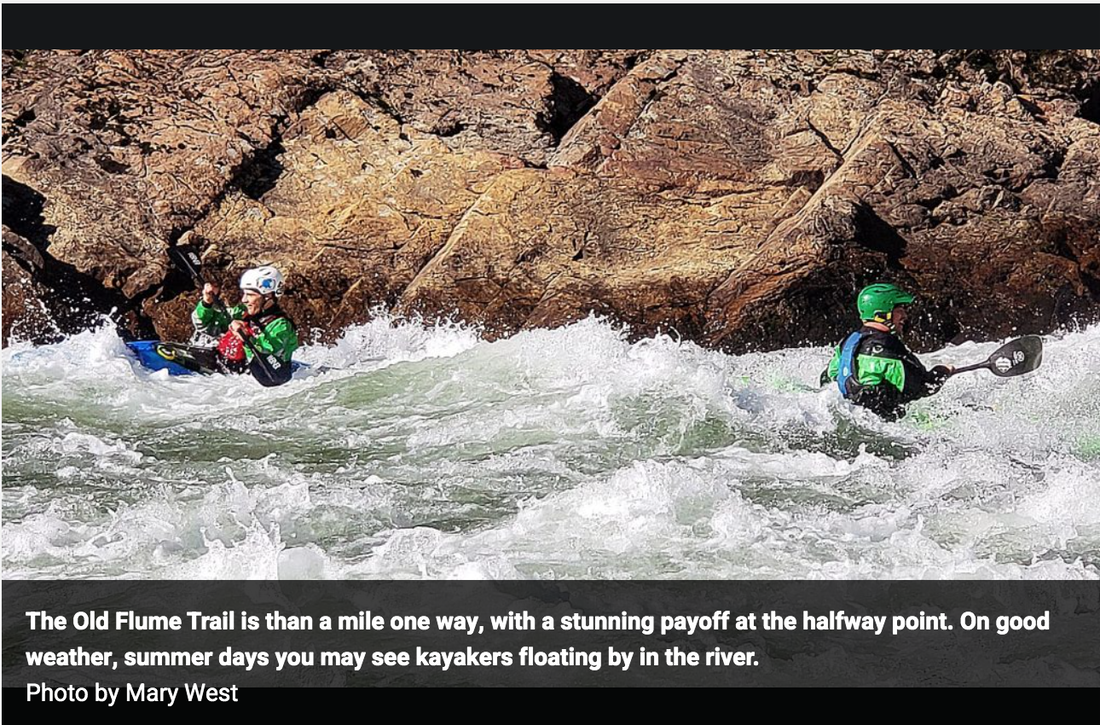
This is a beautiful in an out trail, less than a mile one way, with a stunning payoff at the halfway point. My most recent hike on a cool and sunny day showed off the lush moss on the trees as green ferns unfurled along the canyon walls and a couple of kayakers floating by.
To get there from Auburn head out on Highway 49 South toward Cool. Continue toward Placerville. As you make your way through the canyon, about four miles north of Placerville, look for Red Shack Road on the right. The trail head is directly across the street. Red Shack is a nice stop after your adventure for pulled pork sandwiches or apple pie when open.
----------------
Mary West is author of the book series Day Hiker – The Gold Country Trail Guides. A collection of Day Hiker columns from 2016-2020 (Available on Amazon) where West shares her longtime love of the outdoors, and favorite hikes in Northern California’s Gold Country and beyond. West was the recipient of the 2017 and 2019 CRAFT Award for Best Outdoor Column by the Outdoor Writers of California. You can follow West on Facebook and Instagram.
CLICK HERE to see the complete article in The Union newspaper.
The trail was a road to the river. This road crosses the historic ditch that moved water from Placerville to the ranches in the Gold Hill area. You can read about George and John Luce who managed the flume from 1920 to 1924. The wooden flume is believed to be the tallest in the county at 153 feet and running 750 feet between the ridges. The flume is gone, but the land was gifted to the American River Conservancy in 1999 for our enjoyment.
The trail is wide, but I would call this moderate to difficult depending on your fitness level due to the steep drop into the canyon — about 800 feet in less than a mile. Worth every step when you find yourself rock hopping out to a quiet location just below Racehouse Bend rapid on the South Fork.
It took me a half hour to get from the parking lot to the river. I stopped to check out some spur trails along the way. But it took me nearly an hour to return to the parking lot due to the steep grade. Take your time, take breaks if needed and drink plenty of water.
The trail is wide, but I would call this moderate to difficult depending on your fitness level due to the steep drop into the canyon — about 800 feet in less than a mile. Worth every step when you find yourself rock hopping out to a quiet location just below Racehouse Bend rapid on the South Fork.
This is a beautiful in an out trail, less than a mile one way, with a stunning payoff at the halfway point. My most recent hike on a cool and sunny day showed off the lush moss on the trees as green ferns unfurled along the canyon walls and a couple of kayakers floating by.
To get there from Auburn head out on Highway 49 South toward Cool. Continue toward Placerville. As you make your way through the canyon, about four miles north of Placerville, look for Red Shack Road on the right. The trail head is directly across the street. Red Shack is a nice stop after your adventure for pulled pork sandwiches or apple pie when open.
----------------
Mary West is author of the book series Day Hiker – The Gold Country Trail Guides. A collection of Day Hiker columns from 2016-2020 (Available on Amazon) where West shares her longtime love of the outdoors, and favorite hikes in Northern California’s Gold Country and beyond. West was the recipient of the 2017 and 2019 CRAFT Award for Best Outdoor Column by the Outdoor Writers of California. You can follow West on Facebook and Instagram.
CLICK HERE to see the complete article in The Union newspaper.
 RSS Feed