
To get to Yankee Jim’s Bridge, take Interstate 80 east to Colfax. Take the Canyon Way exit. Turn right onto Canyon Way. Less than a mile down the road you will see Yankee Jim’s on the left. Not far down the road the pavement ends. Follow the road along the mountainside to the bridge to park. Start off by heading down the wooden steps from the roadside up river; if you see an information kiosk, you are headed in the right direction.
The area of the North Fork of the American River around Yankee Jim’s Bridge in Colfax is a destination in itself.
I find myself rock hopping and hiking all around the area when I get a chance. When the water is low you can cross Shirttail Creek with about 2 miles of trail to wander on back to Indian Creek. Along the way are swimming holes filled with crystal clear water and spots of white sand beach. At the creek there is shade and rocks to lounge on in between the swimming, picnicking and hiking.
The blackberries are ripening for an added snack.
The views of the North Fork deep in the canyon with towering forest covered hills all around is as good as it gets.
This trail continues on to Windy Point, if you are so inclined, but with the heat and the narrowness of the trail I kept my most recent hike to 2 miles in, for a 4 mile round trip.
This trail is not consistently maintained. Expect blackberry vines, downed trees, hanging limbs and tall grass. Tall grass is home to ticks. Loose rock is an added danger. Poison oak is mostly dried up but for those of you that are sensitive to it, watch out.
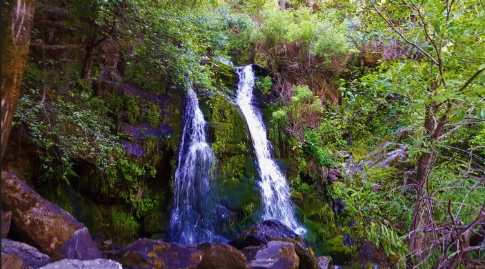
If you have ever felt discouraged by your daily grind, try standing under a waterfall. The rush can make you forget all your deadlines for a day.
Parking is a challenge on the weekends with only eight or 10 cars safely able to park off the road, but 20 or 30 cars try to squeeze in. There is a day use fee of $10 as this is within the boundary of the Auburn State Recreation Area.
To get to Yankee Jim’s Bridge, take Interstate 80 east to Colfax. Take the Canyon Way exit. Turn right onto Canyon Way. Less than a mile down the road you will see Yankee Jim’s on the left. Not far down the road the pavement ends. Follow the road along the mountainside to the bridge to park. Start off by heading down the wooden steps from the roadside up river; if you see an information kiosk, you are headed in the right direction.
Get an early start as much of the trail is exposed to direct sun and heats up. Take plenty of water and a friend if possible. Sturdy shoes and walking sticks are also a good idea. Hats and sunblock will also come in handy.
To see the original article in the Auburn Journal CLICK HERE.
The area of the North Fork of the American River around Yankee Jim’s Bridge in Colfax is a destination in itself.
I find myself rock hopping and hiking all around the area when I get a chance. When the water is low you can cross Shirttail Creek with about 2 miles of trail to wander on back to Indian Creek. Along the way are swimming holes filled with crystal clear water and spots of white sand beach. At the creek there is shade and rocks to lounge on in between the swimming, picnicking and hiking.
The blackberries are ripening for an added snack.
The views of the North Fork deep in the canyon with towering forest covered hills all around is as good as it gets.
This trail continues on to Windy Point, if you are so inclined, but with the heat and the narrowness of the trail I kept my most recent hike to 2 miles in, for a 4 mile round trip.
This trail is not consistently maintained. Expect blackberry vines, downed trees, hanging limbs and tall grass. Tall grass is home to ticks. Loose rock is an added danger. Poison oak is mostly dried up but for those of you that are sensitive to it, watch out.
If you have ever felt discouraged by your daily grind, try standing under a waterfall. The rush can make you forget all your deadlines for a day.
Parking is a challenge on the weekends with only eight or 10 cars safely able to park off the road, but 20 or 30 cars try to squeeze in. There is a day use fee of $10 as this is within the boundary of the Auburn State Recreation Area.
To get to Yankee Jim’s Bridge, take Interstate 80 east to Colfax. Take the Canyon Way exit. Turn right onto Canyon Way. Less than a mile down the road you will see Yankee Jim’s on the left. Not far down the road the pavement ends. Follow the road along the mountainside to the bridge to park. Start off by heading down the wooden steps from the roadside up river; if you see an information kiosk, you are headed in the right direction.
Get an early start as much of the trail is exposed to direct sun and heats up. Take plenty of water and a friend if possible. Sturdy shoes and walking sticks are also a good idea. Hats and sunblock will also come in handy.
To see the original article in the Auburn Journal CLICK HERE.
 RSS Feed