Placer County is requesting your involvement in planning the future of Hidden Falls Regional Park. The county is in the beginning planning stages for the expansion of the trail system from Hidden Falls Regional Park to the Bear River. Through the county’s partnership with the Placer Land Trust, more than 2,500 acres of open space near the park has been acquired for preservation of oak woodland, wildlife habitat and public recreation through additional trails. At completion, the expansion of the park could result in 4,000 acres of contiguous open space with a trail system approximately 60 miles in length.
The next steps for the Hidden Falls expansion will be public outreach and environmental review. Before any physical expansion of the existing trail system on these other parcels is undertaken by the County, this process will analyze existing use, traffic patterns and the current parking situation.
As many of you know, visitation at Hidden Falls has increased dramatically since its 2013 opening. Using actual data from current use will help us plan for long-term management strategies, provide for sustainable parking solutions which limit impacts on adjoining neighborhoods, improve the current user experience and define future opportunities.
Study Locations:
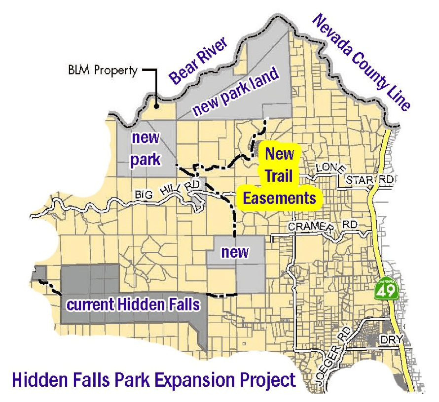
The proposed expansion areas are located north and northeast of the existing park and consist of the areas known as Taylor Ranch (321 acres) and Harvego Bear River Preserve (1,773 acres), as well as privately-owned parcels with trail easements, such as the Liberty Ranch (313 acres). The trails will also cross the Kotomyan Preserve (160 acres) and the Outman Big Hill Preserve (80 acres). Please refer to the map for the locations of these properties in relation to the existing park area. In addition to the expansion of the multi-use trail network, the project would include two bridges across Coon Creek, parking areas, roadway improvements, and other park amenities that would meet the high demand for trails, reduce overflow parking on local roadways, and increase public safety.
Study Process:
The county is in the early stages of planning and will be conducting biological and cultural re- sources surveys, traffic counts on area roadways and trail mapping to gather information to sup- port the required planning and permitting documents. The trail layout will be designed to maximize the use of existing trails and roadways and minimize disturbance of natural resources.
Additional parking opportunities will be explored as a part of the environmental review process. Please be aware that the county will be conducting the traffic and natural resources studies described above in December 2016, and again in the spring of 2017.
HOW YOU CAN HELP -
The county is providing this report to inform you of these early planning efforts and to seek your input on the project. If you would like to join the electronic mailing list to receive future up- dates on this project, please sign up for automatic updates through our Placer County website.
Just click on the green “Newsletter Sign Up” button at the bottom of our website http://www.placer.ca.gov - submit your e-mail address, and then click on the button for the Hidden Falls Park Trails Expansion Project.
If you don’t have access to email, send a written request to be added to the mailing list to Lisa Carnahan, Placer County Parks Division, 11476 “C” Avenue, Auburn, CA 95603.
The county will provide regular updates to those on the mailing list as we move forward with these preliminary planning efforts for expanding the trails network beyond the current Hidden Falls Regional Park.
The next steps for the Hidden Falls expansion will be public outreach and environmental review. Before any physical expansion of the existing trail system on these other parcels is undertaken by the County, this process will analyze existing use, traffic patterns and the current parking situation.
As many of you know, visitation at Hidden Falls has increased dramatically since its 2013 opening. Using actual data from current use will help us plan for long-term management strategies, provide for sustainable parking solutions which limit impacts on adjoining neighborhoods, improve the current user experience and define future opportunities.
Study Locations:
The proposed expansion areas are located north and northeast of the existing park and consist of the areas known as Taylor Ranch (321 acres) and Harvego Bear River Preserve (1,773 acres), as well as privately-owned parcels with trail easements, such as the Liberty Ranch (313 acres). The trails will also cross the Kotomyan Preserve (160 acres) and the Outman Big Hill Preserve (80 acres). Please refer to the map for the locations of these properties in relation to the existing park area. In addition to the expansion of the multi-use trail network, the project would include two bridges across Coon Creek, parking areas, roadway improvements, and other park amenities that would meet the high demand for trails, reduce overflow parking on local roadways, and increase public safety.
Study Process:
The county is in the early stages of planning and will be conducting biological and cultural re- sources surveys, traffic counts on area roadways and trail mapping to gather information to sup- port the required planning and permitting documents. The trail layout will be designed to maximize the use of existing trails and roadways and minimize disturbance of natural resources.
Additional parking opportunities will be explored as a part of the environmental review process. Please be aware that the county will be conducting the traffic and natural resources studies described above in December 2016, and again in the spring of 2017.
HOW YOU CAN HELP -
The county is providing this report to inform you of these early planning efforts and to seek your input on the project. If you would like to join the electronic mailing list to receive future up- dates on this project, please sign up for automatic updates through our Placer County website.
Just click on the green “Newsletter Sign Up” button at the bottom of our website http://www.placer.ca.gov - submit your e-mail address, and then click on the button for the Hidden Falls Park Trails Expansion Project.
If you don’t have access to email, send a written request to be added to the mailing list to Lisa Carnahan, Placer County Parks Division, 11476 “C” Avenue, Auburn, CA 95603.
The county will provide regular updates to those on the mailing list as we move forward with these preliminary planning efforts for expanding the trails network beyond the current Hidden Falls Regional Park.
 RSS Feed