Below the smoke and close to the river, the No Hands Bridge portion of the Western States Trail is a good choice for hiking in fall.
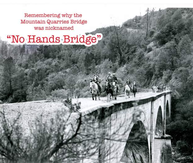
Through gate 150 in the Auburn State Recreation Area, this is an easy two-mile hike on the Western States Trail (WST). The WST crosses the historic Mountain Quarries Railroad Bridge, dubbed “No Hands” by an equestrian years ago. The rider is said to have crossed the bridge before rails were installed, with her hands in the air, declaring “Look, no hands!”
The North Fork of the American River that runs beneath is a refreshment to many park visitors all summer long, making this area very busy on weekends.
This out-and-back trek leads to Canyon Creek and the wooden bridge that crosses it. The waterfall that feeds the creek has been nicknamed the Black Hole of Calcutta. This nickname also came from an equestrian riding the end of the Tevis Cup in the dark of night. But for locals who know the original story, this is just a more convenient location to send visitors who ask to see the Black Hole of Calcutta. The original black hole, a mud puddle, is not much of a destination to take a selfie and share with friends.
The mostly level trail follows the river back to the Canyon Creek Bridge, where the small falls are located. Early mornings or late afternoons are best for me, as most of the crowds have gone so it is easier to park near the trailhead. I can never resist scrambling down to the river to do some rock hopping to the perfect perch just to watch the river roll by.
The history of the bridge and trail is long and storied. Auburn, the self-proclaimed Endurance Capital of the World, is home to the annual Western States Trail Foundation 100-Mile One Day Tevis Cup Ride and the 100-Mile Endurance Run, both starting in Squaw Valley and making its way to Auburn.
Both events are inspirational feats of physical and mental strength. Athletes come from all over the world for the privilege to run the WST and compete with the world’s best equestrians and trail runners. Still more come out for the training runs and fun rides just for the chance to experience parts of this historic path.
Exposed areas of the trail will make you wish you had your sunscreen, hat and glasses. Always take a bottle of water, and I never leave home without a camera. Although not as thick, you can still find poison oak here, and ticks, too.
There are few trails that make me feel at home more than this part of the Western States Trail.
Get to this part of WST by taking Interstate 80 east to Auburn. Take the Elm Avenue exit to Highway 49 toward Placerville. Follow Highway 49 into the canyon. Take the right over the river toward Cool. Just over the bridge on the El Dorado County side, you find gate 150. Park as close to the trailhead as you like and get ready for a great day hike.
Mary West is author of the book series Day Hiker – Gold Country Trail Guide I, II and III (2nd edition available on Amazon). The books are a collection of the Day Hiker columns where West shares her longtime love of the outdoors, favorite hikes in Northern California’s Gold Country and beyond. West was the recipient of the 2017 and 2019 CRAFT Award for Best Outdoor Column and the 2020 Craft Award for her second book in the series – Day Hiker Gold Country Trail Guide by the Outdoor Writers of California. You can follow West on Facebook and Instagram.
CLICK HERE to see Mary's original article in Gold Country Media.
 RSS Feed