| The Quarry Road Trail has been the site of more than one marriage proposal. This month for Valentine’s, I am reminded that I stood at the top of Quarry Road years ago, and appreciated the view of the Middle Fork of the American River leading to the confluence with the North Fork – my eyes taking in the Foresthill Bridge, California’s tallest. I stood smiling my best smile before sharing this trail with someone I had recently met, hoping for the best. The trail only begins with this stunning view. The pleasure is in the walk along the Middle Fork for over a mile. There are picnic tables and chemical toilets along the way. You can see where the kids have scrambled down to get closer to the water, or even see them in the refreshing flow when the summer heat takes its toll. The Middle Fork is significantly colder than the North Fork as the water comes from the bottom of the reservoir upstream, whereas the water for the North Fork has been exposed to the sunshine of Lake Clementine and over the dam. The Quarry Road Trail is popular with all user groups and I find myself often stopping to say hello to friends and neighbors along the way. At the 1.5-mile point of this wide, flat trail, you come to a staging area where you can turn around. Several picnic tables and chemical toilets are located here along with some mining artifacts from days gone by. I prefer to walk up the small hill past the ruins, past the switchbacks that lead to the climbing area, and past the gated entrance to the Hawver mine. Just past the split for the Western States trail on your right, look to your left for a small rock outcropping. If you look closely you will see the wear marks from climbing up these rocks that lead to an amazing view of Murderers Bar Rapids. Be careful. There is a steep drop off on the other side. Early morning is my favorite time as I can watch the sun light the canyon. There is room for two at this unique spot – a great place to pop the question. To get to the Quarry Road Trail take Highway 49 into the canyon and turn right over the Highway 49 bridge which crosses the American river. Just up the road on the left is the entrance to the parking area. This is a fee area for day use. I never thought of this trail as being very romantic. Perhaps because I walk or run (more like jog) this trail, so for me it is about exercise, solitude, and a time for thought and reflection. Then I met someone who did find it romantic. I happened to meet a young man who proposed to his bride on the Quarry Road Trail. He talked about why he chose this trail. He said there is something about the idea of two rivers beginning life’s journey on the peaks of the Sierra Nevada Mountains, and finding their way from the thin needles of a pine tree or dripping from granite boulders to creeks and streams to the river. All the life-giving energy of the water comes together right here in Auburn. Those two rivers meet and continue on together, forever. I found the sentiment touching. I will never see the confluence the same again. And the walk I took years ago? Well, I am happy to say we are still friends to this day. Mary West is a retired radio personality and news reporter with a longtime love of the outdoors, sharing her favorite day hikes in Placer, Nevada, El Dorado and Yuba Counties. Learn more about local trails by following Mary on Facebook, Twitter, Instagram, and YouTube. Go Here to read the article in The Auburn Journal. | 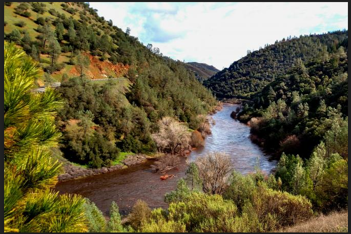 |
|
Comments are closed.
|
Trail NewsVisit this page for all of the latest Trail News that affects our area. Archives
September 2023
Categories |
 RSS Feed