As California forests face another dry summer, firefighters around Lake Tahoe are deploying high-tech mountaintop cameras to spot lightning strikes and the first wisps of smoke before wildfires blaze out of control.
By summer, a network of at least 10 automated cameras will be scanning the heavily forested mountains of the Tahoe Basin and sending back steady streams of images in both the visible and infrared frequencies.
And more cameras are coming, said Graham Kent, director of the Nevada Seismological Laboratory at the University of Nevada, Reno, where the camera network was developed.
Kent sees the cameras as a key to modernizing firefighting techniques everywhere in rough mountain country. Catching a blaze early before its flames spread would save money and lives, and eliminate or reduce the need to send large numbers of fire crews and armadas of trucks and planes, fire experts say.
Last year alone, California forest fires cost $423 million to fight, according to Cal Fire. Across the country the U.S. Forest Service spent more than $1.2 billion fighting fires on its national forests, and those totals are expected to grow as summers grow hotter and drier in this era of climate change.
“The old style of firefighting is like storming the beach at Normandy,” Kent said, “but if you can run a smaller crew on a fire really early, and with their special tools, then it can be more like a situation for the Special Forces.”
The first four fire cameras began operating around the Tahoe Basin two years ago, Kent said, and by last year there were eight. This year there will be 10 in the Tahoe Basin and 11 more around the area “if we can crank it out,” he said.
The instruments, controlled from remote dispatch centers, can tilt, zoom and swivel 360 degrees on command to detect fires and follow them if they spread.
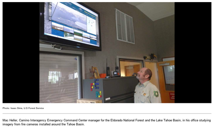
Mac Heller, a fire dispatcher for the Tahoe Basin Management Unit that combines both the Eldorado and Tahoe national forests, recalled one hot evening the summer before last when he was off-duty and the sky over the Sierra was filled with lightning flashes.
Only four cameras were operating in the Tahoe Basin, Heller said, and although he was off-duty, he picked up an image from one of them on his personal laptop. It showed smoke amid the trees at Spooner Summit, a popular hiking area above Lake Tahoe’s eastern shore.
“I called the dispatch office,” Heller said, “and as soon as they spotted it, they sent a really small suppression crew — they needed only about 20 people — but they got a line around that fire fast, and it had only burned about half an acre.
“But who knows how long and how far that Spooner Fire would have burned in the next day or so if it hadn’t been for the camera,” he said. “It could have needed a couple of tanker planes, and a helicopter, and maybe six engines, and who knows how many firefighters.”
Kent and the Tahoe Prosperity Center, a regional community organization, are leading a campaign called AlertTahoe to raise $2 million for 15 more cameras, which would be set up to allow the public to follow the images on home computers, Kent said.
A similar Web-based network of fire cameras, called AlertSoCal, is also operating at 16 mountaintop locations in Southern California, according to Frank Vernon, a research geophysicist at the Scripps Institute of Oceanography.
Vernon and Kent described the two networks at a recent meeting of the Seismological Society of America in Reno.
CLICK HERE to see original article in the San Francisco Chronicle newspaper.
By summer, a network of at least 10 automated cameras will be scanning the heavily forested mountains of the Tahoe Basin and sending back steady streams of images in both the visible and infrared frequencies.
And more cameras are coming, said Graham Kent, director of the Nevada Seismological Laboratory at the University of Nevada, Reno, where the camera network was developed.
Kent sees the cameras as a key to modernizing firefighting techniques everywhere in rough mountain country. Catching a blaze early before its flames spread would save money and lives, and eliminate or reduce the need to send large numbers of fire crews and armadas of trucks and planes, fire experts say.
Last year alone, California forest fires cost $423 million to fight, according to Cal Fire. Across the country the U.S. Forest Service spent more than $1.2 billion fighting fires on its national forests, and those totals are expected to grow as summers grow hotter and drier in this era of climate change.
“The old style of firefighting is like storming the beach at Normandy,” Kent said, “but if you can run a smaller crew on a fire really early, and with their special tools, then it can be more like a situation for the Special Forces.”
The first four fire cameras began operating around the Tahoe Basin two years ago, Kent said, and by last year there were eight. This year there will be 10 in the Tahoe Basin and 11 more around the area “if we can crank it out,” he said.
The instruments, controlled from remote dispatch centers, can tilt, zoom and swivel 360 degrees on command to detect fires and follow them if they spread.
Mac Heller, a fire dispatcher for the Tahoe Basin Management Unit that combines both the Eldorado and Tahoe national forests, recalled one hot evening the summer before last when he was off-duty and the sky over the Sierra was filled with lightning flashes.
Only four cameras were operating in the Tahoe Basin, Heller said, and although he was off-duty, he picked up an image from one of them on his personal laptop. It showed smoke amid the trees at Spooner Summit, a popular hiking area above Lake Tahoe’s eastern shore.
“I called the dispatch office,” Heller said, “and as soon as they spotted it, they sent a really small suppression crew — they needed only about 20 people — but they got a line around that fire fast, and it had only burned about half an acre.
“But who knows how long and how far that Spooner Fire would have burned in the next day or so if it hadn’t been for the camera,” he said. “It could have needed a couple of tanker planes, and a helicopter, and maybe six engines, and who knows how many firefighters.”
Kent and the Tahoe Prosperity Center, a regional community organization, are leading a campaign called AlertTahoe to raise $2 million for 15 more cameras, which would be set up to allow the public to follow the images on home computers, Kent said.
A similar Web-based network of fire cameras, called AlertSoCal, is also operating at 16 mountaintop locations in Southern California, according to Frank Vernon, a research geophysicist at the Scripps Institute of Oceanography.
Vernon and Kent described the two networks at a recent meeting of the Seismological Society of America in Reno.
CLICK HERE to see original article in the San Francisco Chronicle newspaper.
 RSS Feed