Kick off the year with a beautiful 10-mile trek along the South Yuba River. This is a gorgeous hike that takes you from Edwards Crossing to Purdon Crossing on the Yuba River in Nevada County and back again.
Ample parking is available on the south side of the Edwards Crossing bridge. The trail head is well marked heading up river on the south side.
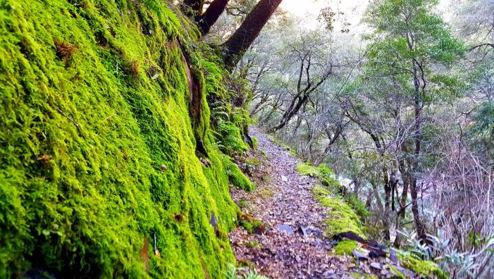
Looking at my GPS tracker, the trail in generally level following the river, but there are many climbs and descents, so trekking poles are a good idea. The best part was the variety of scenery along the trail. You get to enjoy the view of the south Yuba River with heavy flows this time of year. Several rapids make for a thunderous sound against the canyon walls. The succulents, mosses, and ferns were lush and soaked by recent rains. I couldn’t help but reach out and touch them as I hiked.
And boulders on this part of the Yuba are unique. Lying next to your typical gray boulder may be bright orange boulders, stained by the red soils in the area.
On the hillside, you may find round river rock as often as you find slab and sheets on rock broken at angles.
All of this variety is a sure sign of the deeper layers of sediment being exposed due to erosion and the upheaval of the upper levels over the ages.
The bridges start and end the trail. Starting with the green and red, Edwards Crossing. This bridge has seen better days, but its history makes it charming. Built in 1904 the bridge made it possible to access mines on the other side of the river.
The gem is at the halfway point 5-miles in at Purdon Crossing. This bridge built in 1895 was built after several wooden bridges had been washed away. The surprisingly well-maintained bridge is a great spot to rest, enjoy lunch, and prepare for the walk back....Take I-80 north towards Lake Tahoe, exit onto Highway 49 heading north towards Grass Valley. Just above Nevada City. Here you will make a left and continue on Highway 49 towards Downieville. Take the first right onto Coyote St. Follow it until it T’s into North Bloomfield Rd. Turn right onto North Bloomfield and continue down until you come to Edwards Crossing. The last couple miles of North Bloomfield Rd. are a steep and narrow downhill grade with plenty of twists and turns.
No day use fee for parking is an added bonus.
Photo and article by Mary West)
CLICK HERE to see photos and the complete article by Mary West in the Auburn Journal
Ample parking is available on the south side of the Edwards Crossing bridge. The trail head is well marked heading up river on the south side.
Looking at my GPS tracker, the trail in generally level following the river, but there are many climbs and descents, so trekking poles are a good idea. The best part was the variety of scenery along the trail. You get to enjoy the view of the south Yuba River with heavy flows this time of year. Several rapids make for a thunderous sound against the canyon walls. The succulents, mosses, and ferns were lush and soaked by recent rains. I couldn’t help but reach out and touch them as I hiked.
And boulders on this part of the Yuba are unique. Lying next to your typical gray boulder may be bright orange boulders, stained by the red soils in the area.
On the hillside, you may find round river rock as often as you find slab and sheets on rock broken at angles.
All of this variety is a sure sign of the deeper layers of sediment being exposed due to erosion and the upheaval of the upper levels over the ages.
The bridges start and end the trail. Starting with the green and red, Edwards Crossing. This bridge has seen better days, but its history makes it charming. Built in 1904 the bridge made it possible to access mines on the other side of the river.
The gem is at the halfway point 5-miles in at Purdon Crossing. This bridge built in 1895 was built after several wooden bridges had been washed away. The surprisingly well-maintained bridge is a great spot to rest, enjoy lunch, and prepare for the walk back....Take I-80 north towards Lake Tahoe, exit onto Highway 49 heading north towards Grass Valley. Just above Nevada City. Here you will make a left and continue on Highway 49 towards Downieville. Take the first right onto Coyote St. Follow it until it T’s into North Bloomfield Rd. Turn right onto North Bloomfield and continue down until you come to Edwards Crossing. The last couple miles of North Bloomfield Rd. are a steep and narrow downhill grade with plenty of twists and turns.
No day use fee for parking is an added bonus.
Photo and article by Mary West)
CLICK HERE to see photos and the complete article by Mary West in the Auburn Journal
 RSS Feed