By Joan Merriam
Last month, I shared some ideas for walking with your dog in the lower-elevation areas of our region. Now that we’ve begun experiencing some of the sweltering days that summer can bring, let’s take a look at options for hikes in cooler, higher destinations.
Pioneer Trail
If you want to hike with your dog into the county’s more remote mountain region, you couldn’t ask for anything better than the Pioneer Trail. Beginning at the Harmony Ridge Market on Highway 20 across from the Wheelhouse, the trail parallels the highway all the way to White Cloud, where it crosses the road and heads well into the back country, down to Bear Valley, and eventually to Lake Spaulding. (A lesser-known route is the Harmony Trail, which takes off at the market and marches parallel to and below the Pioneer Trail for a few miles and then drops down into the Rock Creek watershed.) There are a number of spots further up Highway 20 where you can catch the trail, including the Conservation Camp turnoff, Lone Grave, White Cloud and Omega Road.
Hallelujah Trail
A little farther up Highway 20 is the Skillman Horse Camp, the starting point for this trail that’s part of an interconnected network that includes the Stanton, Big Tunnel, Omega, and Towle Mill trails, plus the Pioneer. Be aware that this is a multi-use route, which means that you’ll encounter everything from mountain bikers to horseback riders to joggers. The area includes more than 10 miles of trails, so bring along a picnic lunch!
Pacific Crest Trail
While you probably know that the Pacific Crest Trail runs from Mexico to the Canadian border, you may not know that it also traverses part of Nevada County. From Interstate 80 at Boreal, the trail crosses Donner Pass Road just east of Sugar Bowl and heads north-northeast into Sierra County, and south into Placer County. Since this trail traverses extremely wild and rugged country, much of it at elevations above 7,000 feet, be sure both you and your dog are in shape, and that you’re fully prepared with water and food. Go to the Pacific Crest Trail Association website at http://www.pct.org for detailed information and maps.
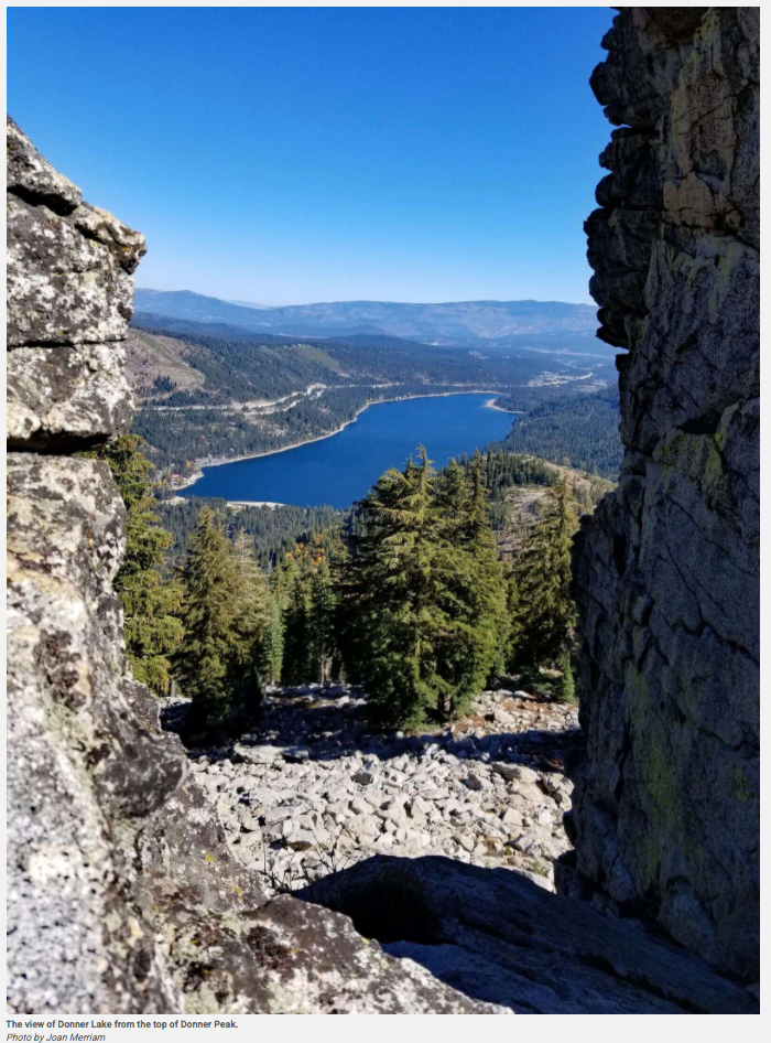
Mt. Judah/Donner Peak Trail
Another high-elevation hike offers some of the most breathtaking long-range views of Donner Lake you’ll ever find. The trail starts off with a nasty field of loose granite you need to traverse, and the last leg up to the top of Mt. Judah is very exposed and windy, but the rest of the hike is considered “moderate,” and the views are worth the struggle. It’s easily accessible from Interstate 80, just four miles from the Soda Springs exit.
Donner Rim Trail
Encircling Donner Lake itself is the Donner Lake Rim Trail, which eventually will run 23 miles from Truckee to Donner Summit. Fifteen miles of the trail are now complete, snaking through the forests of huge cedars and alongside massive granite boulders left from the last Ice Age. Along the way, you’ll find magnificent views of Donner Lake, Mount Rose and the Pacific Crest. This too is a very high-elevation hike, starting at 6500 feet and eventually reaching almost the 8000-foot level. Exit I-80 at the Donner Lake Interchange; on the north side of the freeway is a large dirt parking lot
Doggie Rules of the Road
No matter where you decide to go in our high country, keep in mind these “rules of the road:”
• Always bring plenty of water for both you and your pup
• Carry snacks like nuts, dried fruit, or granola bars that are nutritious, give you energy, and aren’t too filling. (And carry snacks for your dog, too!)
• If you’re hiking solo, tell someone where you’re going and when you’ll be back
• Bring along a first-aid kit just in case
• Keep your cell phone and a compass with you; it’s very easy to get lost or hurt in the back country
• Bring a leash, and obey trail rules about dogs on- or off-leash
• Leave no trace: leave what you find along the trail, and don’t leave your garbage for someone else to pick up
You can find information on more high-country trails in our area on Nevada County Gold, www.GoNevadaCounty.com, www.MotherLodeTrails.com, and the US Forest Service. To find hiking trails that are especially dog-friendly, go to DogTrekker.com.
See you on the hiking trail!
Joan Merriam lives in Nevada County with her Golden Retriever Joey, her Maine Coon cat Indy, and the abiding spirit of her beloved Golden Retriever Casey in whose memory this column is named. You can reach Joan at [email protected]. And if you’re looking for a Golden, be sure to check out Homeward Bound Golden Retriever Rescue
To see the original article and photos in The Union, CLICK HERE.
Last month, I shared some ideas for walking with your dog in the lower-elevation areas of our region. Now that we’ve begun experiencing some of the sweltering days that summer can bring, let’s take a look at options for hikes in cooler, higher destinations.
Pioneer Trail
If you want to hike with your dog into the county’s more remote mountain region, you couldn’t ask for anything better than the Pioneer Trail. Beginning at the Harmony Ridge Market on Highway 20 across from the Wheelhouse, the trail parallels the highway all the way to White Cloud, where it crosses the road and heads well into the back country, down to Bear Valley, and eventually to Lake Spaulding. (A lesser-known route is the Harmony Trail, which takes off at the market and marches parallel to and below the Pioneer Trail for a few miles and then drops down into the Rock Creek watershed.) There are a number of spots further up Highway 20 where you can catch the trail, including the Conservation Camp turnoff, Lone Grave, White Cloud and Omega Road.
Hallelujah Trail
A little farther up Highway 20 is the Skillman Horse Camp, the starting point for this trail that’s part of an interconnected network that includes the Stanton, Big Tunnel, Omega, and Towle Mill trails, plus the Pioneer. Be aware that this is a multi-use route, which means that you’ll encounter everything from mountain bikers to horseback riders to joggers. The area includes more than 10 miles of trails, so bring along a picnic lunch!
Pacific Crest Trail
While you probably know that the Pacific Crest Trail runs from Mexico to the Canadian border, you may not know that it also traverses part of Nevada County. From Interstate 80 at Boreal, the trail crosses Donner Pass Road just east of Sugar Bowl and heads north-northeast into Sierra County, and south into Placer County. Since this trail traverses extremely wild and rugged country, much of it at elevations above 7,000 feet, be sure both you and your dog are in shape, and that you’re fully prepared with water and food. Go to the Pacific Crest Trail Association website at http://www.pct.org for detailed information and maps.
Mt. Judah/Donner Peak Trail
Another high-elevation hike offers some of the most breathtaking long-range views of Donner Lake you’ll ever find. The trail starts off with a nasty field of loose granite you need to traverse, and the last leg up to the top of Mt. Judah is very exposed and windy, but the rest of the hike is considered “moderate,” and the views are worth the struggle. It’s easily accessible from Interstate 80, just four miles from the Soda Springs exit.
Donner Rim Trail
Encircling Donner Lake itself is the Donner Lake Rim Trail, which eventually will run 23 miles from Truckee to Donner Summit. Fifteen miles of the trail are now complete, snaking through the forests of huge cedars and alongside massive granite boulders left from the last Ice Age. Along the way, you’ll find magnificent views of Donner Lake, Mount Rose and the Pacific Crest. This too is a very high-elevation hike, starting at 6500 feet and eventually reaching almost the 8000-foot level. Exit I-80 at the Donner Lake Interchange; on the north side of the freeway is a large dirt parking lot
Doggie Rules of the Road
No matter where you decide to go in our high country, keep in mind these “rules of the road:”
• Always bring plenty of water for both you and your pup
• Carry snacks like nuts, dried fruit, or granola bars that are nutritious, give you energy, and aren’t too filling. (And carry snacks for your dog, too!)
• If you’re hiking solo, tell someone where you’re going and when you’ll be back
• Bring along a first-aid kit just in case
• Keep your cell phone and a compass with you; it’s very easy to get lost or hurt in the back country
• Bring a leash, and obey trail rules about dogs on- or off-leash
• Leave no trace: leave what you find along the trail, and don’t leave your garbage for someone else to pick up
You can find information on more high-country trails in our area on Nevada County Gold, www.GoNevadaCounty.com, www.MotherLodeTrails.com, and the US Forest Service. To find hiking trails that are especially dog-friendly, go to DogTrekker.com.
See you on the hiking trail!
Joan Merriam lives in Nevada County with her Golden Retriever Joey, her Maine Coon cat Indy, and the abiding spirit of her beloved Golden Retriever Casey in whose memory this column is named. You can reach Joan at [email protected]. And if you’re looking for a Golden, be sure to check out Homeward Bound Golden Retriever Rescue
To see the original article and photos in The Union, CLICK HERE.
 RSS Feed