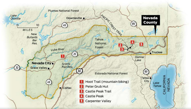
To the north are more rocky peaks that give way to green valleys and shape the Pacific Crest Trail. To the west is a swath of 50 miles that extends from the high Sierra crest downslope to the South Yuba River. You’re sitting atop the crown jewel of Northern California’s high country.
All around is Nevada County.
The slopes here, which flank Grass Valley and Nevada City and run up the hill, as we say, to the high country north of Truckee and Tahoe, have a historic feel. After all, not long ago they were prospected and panned during the gold rush era. Today, they represent one of the state’s best outdoor playgrounds.
You don’t have to look far to discover some of Northern California’s most rewarding day hikes and burly, brand-new mountain bike trails. Paddlers and boaters have their pick of the pristine Donner and Independence lakes. And modest development in the area means private campsites and funky lodging options abound.
From atop Castle Peak, you can see Highway 20 cutting across the landscape, from Nevada City east to Interstate 80 near Truckee, like an artery of access. And yet, if you peer down from your perch to the I-80 corridor, you’ll see one car after another — 26,000 per day, according to Caltrans — sail right on past, en route to north Tahoe and Reno.
Highway 20 provides the launch point for the Pioneer Trail — some of the best mountain biking in California. From the Omega Overlook (with a view of the South Yuba Canyon), the route extends 24 miles one-way to Five Mile House. Like so many sites in Nevada County, it captures the area’s rich history. Gold seekers originally established this route in the 1850s.
Another former gold-mining route is the South Yuba Independence Trail. This trail runs along the gorgeous South Yuba River, with easy access at a bridge and hairpin turn along Highway 49 seven miles out of Nevada City. It’s gorgeous right from the parking lot. Or you can walk as far as 4.5 miles out and back. Most visitors walk a mile or two, find a swimming pool and wade out to cool off.
The Spenceville Wildlife Area in the foothills near Smartville is another place I find myself going back to, again and again. For hiking, wildlife watching and exploring, the best access point is the old (and closed to vehicles) wood bridge at Dry Creek on Spenceville Road. This marks the start of a hike along a creek corridor chock full of wild turkeys and deer in the fall, plus a pretty stream and a surprise waterfall at a small spring.
From miles around you can look up through the trees and spot Castle Peak, rising above, anchoring this vast scope of land. Whether you’re sitting at its summit or trundling across the land below, it’s not hard to imagine what is possible here, and how these adventures can transform your life.
Exploring: Carpenter Valley
A few miles north of Donner Lake as the crow flies, behind a subdivision, a jeep trail heading toward the Sierra Crest plunges into a dense forest of pines and firs. Threading granite boulders that were stranded 10,000 years ago by melting glaciers, the trail leads to an expanse of golden grasses and a slow winding creek. Migrating birds flit through willows, and the primordial calls of sandhill cranes crack the stillness.
This is Carpenter Valley, a long-fenced-off landscape that has recently — and for the first time ever — been opened to the public. There are plenty of meadows in the western Sierra, but not many of them remain this pristine, having been plated with homes or foraged by cattle and sheep.
This summer, a 1,317-acre parcel of the valley’s lower section, long held by three families as a private retreat, was purchased for $10 million by San Francisco’s Northern Sierra Partnership, the Nature Conservancy and the Truckee Donner Land Trust. “The Lower Carpenter Valley is a little bit of heaven,” says Lucy Blake, president of the Northern Sierra Partnership, a San Francisco nonprofit group working to preserve lands north of Lake Tahoe.
The valley links a constellation of nearby protected areas, including Webber and Independence lakes, Perazzo Meadows and Webber Falls — all of which are clustered west of Highway 89 between Truckee and the Sierra Valley. Buying it is part of the Partnership’s broader mission to dissolve a checkerboard of parcels stamped on the mountains in the 1860s during construction of the transcontinental railroad.
“It’s amazing to see the landscape come back together again,” Blake says.
Twice a week this fall, through the end of October, as well as next spring and summer, trained docents are leading hikers on a 5-mile route along the North Fork of Prosser Creek in the valley. The apex of the tour is a natural spring at the flank of Carpenter Ridge that produces startling gardens of hillside color.
The valley is a haven for migrating birds, including willow flycatchers, of which only 200 pairs remain in California, says Helen Loffland, a meadows species specialist at the Institute for Bird Populations. “They perch on the tallest branches of the willows, and throw their heads back when they sing; their white chins look like cotton balls.”
Book a Truckee Donner Land Trust guided tour of Lower Carpenter Valley at http://tinyurl.com/yatwnvqo.
— Laura Read
Hiking: Castle Peak
The name says it all: the 9,104-foot crag is a treeless fortress fronted by rock turrets.
From the summit of Castle Peak, on days with crystalline clarity, you can get glimpse of Lake Tahoe 20 miles southeast. Turn around and you may be able to pick out Lassen Peak, far to the north.
The moderate, 7-mile-round-trip trek up Castle Peak is a popular one in midsummer, but as fall approaches, you can often have it to yourself — particularly on weekdays. To find the trailhead, exit north off of I-80 at Boreal/Castle Peak and look to your right.
The hike starts easy, from an old jeep road, then traces a ridgeline toward the backside of the peak, but the end is grueling: a 1,200-foot elevation gain in the final mile and a half. That last leg includes a stretch of switchbacks, which allows you to get into rhythm, through rock and scree. You then circle around the back of the mountaintop, and make the scramble on small crags to the summit pinnacle.
— Tom Stienstra
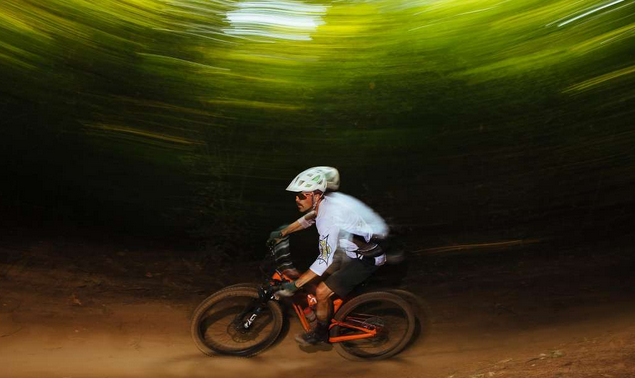
Mountain Biking: the Hoot Trail (Photo by Mason Trinca, Special To The Chronicle: Jeremy Benson rides down the Hoot Trail near Nevada City.)
Last spring, when trail builders finished constructing Nevada City’s new Hoot Trail, a 1.4-mile multiuse path featuring 438 feet of curves and banked turns, mountain bikers flocked to the area, further cementing Nevada County as a destination for the growing sport. (Note: this trail is multi-use and please be aware of other users.) The trail-building organization Bicyclists of Nevada County estimates that the trail sees roughly 50 to 100 riders a day, making it the most popular ride in the area.
Located 5 miles from downtown Nevada City off Highway 20, the Hoot is part of an exceptional and growing network of trails that also includes the 3-mile twisting downhill of Scott’s Flat Trail, the beginner-friendly rolling Pioneer Trail that parallels the highway, and the more technical Miner’s Trail and Taxi Cab, which descend precipitously into town. With more offerings bringing more grinders to town, no longer is the sport confined to the bike shop.
“Nevada City has long been a mountain bike destination, but recently, a growing mountain bike culture and community have taken it to a whole new level,” says Truckee mountain biker Jeremy Benson, author of a new guidebook, “Mountain Bike Tahoe.” “Not only is the Hoot Trail ridiculously fun, but it’s perfectly situated to link up with other nearby trails to create any length ride you want.”
Don’t have a bike? You can rent a full-suspension mountain bike — and get maps to the local trails — from the Tour of Nevada City Bicycle Shop in downtown. From $65 a day; www.tourofnevadacity.com
— Megan Michelson
Camping: Peter Grubb Hut
In 1937, the Sierra Club named its new Donner Pass hikers hut after a teenager who had scrambled all over the Sierra studying glaciers, counting bighorn sheep and skiing the untamed cirques and meadows.
Today the Peter Grubb Hut, tucked in a valley beneath Castle Peak, is one of the club’s most popular daytime and overnight destinations. It is one of four similar structures built by Sierra Club volunteers more than 50 years ago to support multiday backcountry trips between Castle Pass and Desolation Wilderness west of Lake Tahoe. The northern three huts — Peter Grubb, Benson and Bradley — are a day’s hike or cross-country ski apart. The fourth is 20 miles south of the Bradley Hut across rugged terrain.
The 3-mile route to the Peter Grubb Hut traverses the 7,880-foot-elevation Castle Pass. The A-frame cabin resembles a supersize gnome house. Its main floor dips into the ground, and an exterior ladder reaches to a second-story entrance. Inside you’ll find mattresses, wood stoves and enough space for 15 people.
While rates are cheap ($20/night by reservation only), responsibilities are high. Users are the caretakers, and volunteers stock firewood in the fall.
For reservations, call (530) 426-3632 or email [email protected]
— Laura Read
----------------------------------------------------------
Tom Stienstra is The San Francisco Chronicle’s outdoor writer. He is the author of “Moon California Hiking.” E-mail: [email protected] Twitter: @StienstraTom
CLICK HERE to see all the photos and read the original article by By Tom Stienstra in the San Francisco Chronicle newspaper published on September 17, 2017


 RSS Feed