MOTHER LODE TRAILS
  • Home
  • About
  • Contact
  • Volunteer
  • Links
    • Law Enforcement Emergency
    • Federal, State, County Districts Parks & Trails
    • Running Clubs
    • Equestrian Clubs
    • Mt. Bike Clubs
    • Hiking Clubs
    • Trail Advocacy Organizations
    • Phone Numbers State & Federal Parks, Trails & Lands
    • Where to Eat on the Trails
  • News
  • Alerts

What to expect when trekking the Buttermilk Bend in South Yuba River State Park

3/23/2018

 
Picture
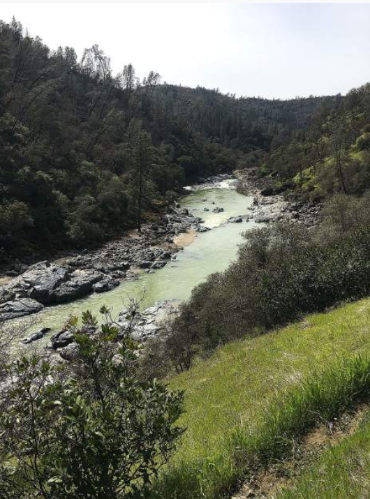
Buttermilk Bend — an in-and-back trail that lies within the South Yuba River State Park — is undoubtedly the path that Goldilocks would have chosen. It's not too steep, not too flat, not too long, not too short and is overall just a pleasant place to take in the scenery of the South Yuba. Photo by Jennifer Nobles

Family-friendly with beautiful views as you walk along the river, Buttermilk Bend is a moderately busy trail that is dotted with abundant wildflowers this time of year. On a recent Sunday, there was ample parking in the designated lot (just remember to bring $5 for your parking fee.)

My hiking buddy for the day was Nevada City's Jesse Locks, who is not only an avid and accomplished hiker, but is the founder of the Folk Trails Hiking Club. Among her many treks she counts the completion of the Tahoe Rim Trail, which she achieved a couple of years ago.

When asked what she would most like people to know about hiking Buttermilk Bend — and hiking in general — Locks was quick with her reply.
"Just for people to leave everything looking better than they found it," she said. "If you see a piece of trash, pick it up. Even orange peels are considered litter.
"Also, stay on the trail. The impact of going off-trail is hard on the ecosystem [of the trail]. Don't step in puddles or the soft mud that can result from rain. Everything counts."

"Oh," she said, "and the person walking uphill on any trail gets the right-of-way."

Sights on the trail
On the day of our walk the trail was in good condition, especially considering the stormy March weather we've been experiencing. The water raging below us was the color of green marble — it was pretty but opaque; agitated but not dirty. (It should be noted that however beautiful, the river is indeed roiling and is considered much too dangerous for swimming or water play.)

As mentioned, the flora and fauna along Buttermilk Bend are beautiful this time of year. The trail was absolutely plentiful with fluttering butterflies, crossing our paths and nearly landing on us as they gracefully danced through the air. At times it felt like a fairyland, with gentle wisps of the winged creatures breezing past us.

As for the plants and flowers, they were reminders that spring is indeed here. Hundreds if not thousands of California Poppies, Native Redbud, and lupine line the path, along with a myriad of others. Many different species of flora are marked clearly, to help hikers identify the plants.

One plant that all hikers should learn to recognize if they haven't already is Toxicodendron diversilobum, better known as Western Poison Oak. There is a remarkable amount of the stuff along the trail — more than any other plant — much of it young and red; much of it hasn't reached its peak yet but should undoubtedly be avoided nonetheless.

There are some notable features along Buttermilk Bend: a number of benches are available on which to rest, and dogs are welcome on the trail as long as they are leashed.

Several wooden foot bridges can be found along the way. An upper trail devoid of any drastic climbs has been added by erecting two additional bridges across river tributaries. The upper trail intersects with the older trails about .2 mile from the parking area.

The trail is a doable 2.4 miles round-trip, making it a great selection for those with children or inexperienced hikers. The path has been made wide enough for wheelchair accessibility and is gently sloped.

If you look up from the trail (stop before doing so, and always be mindful of your footing), you will see a number of naturally occurring waterfalls, all the result of the recent storms that have delivered inches of rain and snow to the foothills.
Buttermilk Bend is a great place to start if you have been curious about hiking along the majestic Yuba. With its friendly and unintimidating nature, many will find peace and pleasure rambling along its delicate path.
Locks waxed poetic when extolling the many virtues of the trail.

"I love that on Buttermilk, you see people, but they're almost always people you know," she said. "It's a very friendly place."

Jennifer Nobles is a freelance writer for The Union and can be contacted at jenkrisnobles@gmail.com

To see this complete article and more pictures in The Union newspaper, CLICK HERE.


Mt. Shasta Making Significant Improvements to Trails, Becomes First "Trail Town"

3/22/2018

 
Mount Shasta is an incredible destination for outdoor enthusiasts. The trails, waterways, hills, slopes and views provide an amazing experience for all that visit the area. Now, Mt. Shasta is making significant improvements to the areas trail system while also being recognized as the first ever "Pacific Crest Trail Town."

At a recent Forest Service meeting in Mt. Shasta, 150 people showed up to voice their support of a new proposal that would add 45 miles of new trails to the area. The proposal was put together as a joint effort by the Mt. Shasta Trail Association and the Forest Service.

Following the meeting, the new proposal received a $420,000 grant from the McConnell Foundation to move forward. And, just like that, the Mt. Shasta trail system is about to get much better.

A local forest service said that on any given day, 7 of 10 trails in the Mt. Shasta area are at capacity. With 45 new miles of trails, the love will be spread out much more. Here is a map of the new trail system:

Picture
Trail TownIn related news, the Pacific Crest Trail Association just named Mt. Shasta as its first ever "Pacific Crest Trail Town." As a Trail Town, hikers on the world-famous Pacific Crest Trail (which goes right through the Mt. Shasta Area) will be directed to the Mt. Shasta as a premiere destination on the trail.

“Our goal with the trail towns program is not only to promote communities as rest and resupply stops for long-distance hikers,” said PCTA communications director Scott Wilkinson, “but also to benefit local economies by helping towns near the PCT promote themselves as destinations for hiking and other outdoor recreation.”

The official introduction of Mt. Shasta as a trail town will occur on July 19th of this summer. Under the program, hikers on the 2,650-mile PCT will be guided towards the town as a place to rest, re-up on supplies and maybe get a nice shower. This should be a nice boost to the local economy as well as an official endorsement of Mt. Shasta as a great outdoor town.
These great improvements to Mount Shasta are welcomed to improve the outdoor activities in the area and cement it as NorCal's premiere outdoor destination. A big thanks to everyone involved!

Click here to see original story in the NorCal Active.

Final funding of $5,500,000 in place for South Lake Tahoe's paved Greenway Shared Use Bike Trail

3/16/2018

 
Picture
The next phase of the South Tahoe Greenway Shared Use Trail will now be completed by El Dorado County, a move that is estimated to save $1,000,000. During this week's meeting of the California Tahoe Conservancy Board, approval was given to the transfer of a $3.182 million grant to El Dorado County to build the next phase of the South Tahoe Greenway Shared Use Trail. Conservancy staff recommended transferring the project from the State to the County who they said is in an advantageous position to deliver the project, and has indicated that it can complete the Project in a timely manner.

The Conservancy completed construction of the first phase in October 2015, providing a .42-mile neighborhood connection between Glenwood Way and Herbert Avenue.

The Greenway is a 3.86-mile trail connection between the Tahoe Sierra (formerly “Sierra Tract”) neighborhood and Van Sickle Bi-State Park. The trail alignment generally follows the decades old right-of-way originally obtained by Caltrans to build a bypass freeway.

“This portion of the trail is an important link between the Tahoe Sierra and Bijou neighborhoods, Lake Tahoe Community College, and the community playfields said El Dorado County Supervisor and Conservancy Board Member Sue Novasel. “The County is well positioned to construct the trail, given its extensive experience building trails in sensitive environments at Lake Tahoe.”

“The Greenway Trail is the result of a strong partnership between the Conservancy, the College, the City of South Lake Tahoe, and the Lake Tahoe Bicycle Coalition and we are pleased to now include El Dorado County in this partnership,” said Conservancy Board Chair Brooke Laine. This was Laine’s first full meeting as Chair, replacing longtime Chair Larry Sevison.
Lake Tahoe Community College, the City of South Lake Tahoe and the Tahoe Conservancy have been partners in the project that included land swaps and funding. The County's participation is the last piece of the puzzle.

To date, the Conservancy board has authorized $2,662,000 for planning, preliminary designs, and acquisitions for the entire Greenway, and final design and construction of the first section of the Greenway (Phase 1a). The Conservancy and the Department of General Services (DGS) completed construction of Phase 1a in October 2015, providing a 0.42-mile neighborhood connection between Glenwood Way and Herbert Avenue. The Project extends the shared use trail for about a mile from the terminus of Phase 1a at Glenwood Way to Sierra Boulevard. Together with Phase 1a and a previously completed trail by the community ballfields, the Project will provide almost two miles of continuous shared use trails in the heart of South Lake Tahoe. The Project includes a new bridge over Trout Creek, improved local street crossings, interpretive and wayfinding signage, and significant sections of raised boardwalk to protect sensitive stream environment zone.

This next phase will cost $5,500,000, with this $3,182,000 ($2,532,000 coming from Conservancy and $650,000 from LTCC), $1,928,000 from Caltrans Active Transportation Program (ATP) grants and $390,000 from Tahoe Transportation District Congestion Mitigation and Air Quality (CMAQ) funds.

Construction will start in 2019 and estimated completion in 2020.

CLICK HERE to see original article in South Tahoe Now news.

From Folsom Telegraph GM: Take it slow on the Folsom trails

3/12/2018

 
Picture
"It can be pretty intimidating to be cruising along and having someone an inch in line behind your drafting like they are in a NASCAR race."
A week ago, we did a story on the lengthy closure of the American River Parkway Trail due to a landslide that blocked the area in January of last year. Knowing we needed a photo of the area that cyclists have been talking about, I decided that riding to the location would be far smarter than walking the entire way so I brought the mountain to work one weekend. 

Photo: Bill Sullivan, General Manager, Folsom Telegraph Newspaper

Packing the camera gear in a backpack, I made the trek on a pedal version of what many of us remember as the “Les Nessman news mobile.” Only those who watched an old sitcom known as WKRP in Cincinnati will understand that reference, but to sum it up, it’s not the fastest method to get to a news story.

After getting the needed photos and being out of shape by the time I got back to the office, loading my bike back into my car seemed equivalent to competing in a triathlon. Therefore, I went lazy and decided to just leave the bike at the office, telling myself I would start riding after work each night or come down on the weekends to ride the more scenic and flatter area trail that borders the south side of Lake Natoma.

As far as telling myself and my imaginary witness that I would start riding every day after work, that hasn’t happened, I’m using daylight savings time as the delay on that plan. However, I did come down to historic Folsom on Sunday to take an afternoon ride, and I learned a few things on it.

First of all, I already knew our trails in Folsom are second to none, but I had forgotten how beautiful this particular one is, especially as the afternoon sets and illuminates Lake Natoma. I am not one who enjoys riding on the pavement fulltime. I enjoy getting off the populated trails and taking to dirt. Part of it is the adventure, part of it is probably because I grew up in the country and dirt roads were like treasures to a kid, whether you were on a bike, a go kart and eventually a car. The dirt road was where the most fun was had and the most scars were made.

The main reason I like to get off the paved routes is I am one who likes to get away from the crowd, so to speak. In this job, I work closely with people, in person, on phones, online; you name it, so it’s nice to get away from it all. However, there is another reason I tend to take the road less traveled and that’s simply because there are so many on our trails these days that lacks courtesy to others.

I will be the first to admit I am not the fastest rider. I was always the slow kid on the playground; the one that prayed that the fly ball never flew in my direction. I was the one that was only in front running laps when I was getting lapped and ironically, the one who was always picked first as the target in dodge ball.  

Just taking a casual ride on our local trails can be daunting at times. Many riders are courteous and politely let you know if they are passing on the left; many are not. It can be pretty intimidating to be cruising along and having someone an inch in line behind your drafting like they are in a NASCAR race or passing you at top speed and not letting you know. This is just common courtesy we all should practice. I am an adult, and I can deal with it, but it made me think of the families with little ones on the trail that aren’t prepared for that (speeding bikes). It wasn’t long ago a walker was struck and injured by a cyclist nearby, and that just shouldn’t happen. 

Another observation, so many folks disregard the signage that tells them what side to be on, so those of us on wheels have to weave in and out of walkers or in some cases go off the trail to get by. Lastly, and I noticed this on my recent ride as well, folks walking Fido all too often have an extra long leash that goes all the way across the track. For the slow guy on the trail like me, that’s not too much of an issue, but for the avid rider that is passing the slow guy, that’s not going to end well.

We have beautiful trails here in our city. If we all work together to give everyone a little elbow room as we enjoy them, it works out for all. Most of all, it will make visitors to our city feel welcome and wanting to come back to enjoy our area more and more. Let’s all do our part.

Bill Sullivan is the Associate Publisher of Gold Country Media and the General Manager of the Folsom Telegraph. He can be reached at bills@goldcountrymedia.com.


US House candidate and pro mt. bike racer, "Do not open up wilderness to bicycles."

3/6/2018

 
Picture
Democratic U.S. House candidate Grant Kier is running for office and is a former professional mountain bike racer. In this report on one of his campaign stops, Keir was asked by Columbus City, MT, resident Lee Johnson about his position on allowing mountain biking in wilderness areas. 

Kier said as a former professional mountain bike racer his position is not to open up wilderness to bicycles.

“I think the last thing we need is for mountain bikers to fight with trail runners to fight with hikers,” said Kier.  He said Republicans are already trying to weaken public lands.

CLICK HERE to read the complete article on Montana Public Radio website.


Mountain Biker Distortions On Wilderness Act in Sac Bee

3/2/2018

 
Picture
 Kurt Gensheimer’s Feb. 28th opinion on mountain biking and wilderness in the Sacramento Bee is full of the same misinformation and distortions. Mr. Gensheimer suggests that Rep. Tom McClinock’s legislation to open our nation’s wilderness system to mountain bikes and other wheeled contractions “restores” the original intent of the  1964 Wilderness Act and will provide access.
Ironically, Wilderness Areas are accessible to anyone so long as they leave behind their mechanical transportation.
It appears that Mr. Gensheimer hasn’t read the Wilderness Act.
The Wilderness Act’s opening paragraph states: “In order to assure that an increasing population, accompanied by expanding settlement and growing mechanization, does not occupy and modify all areas within the United States and its possessions, leaving no lands designated for preservation and protection in their natural condition, it is hereby declared to be the policy of the Congress to secure for the American people of present and future generations the benefits of an enduring resource of wilderness.” To read Kurt Gensheimer's opinion, go here:
http://www.sacbee.com/opinion/california-forum/article202387639.html
The Act further goes on to state that “there shall be no temporary road, no use of motor vehicles, motorized equipment or motorboats, no landing of aircraft, no other form of mechanical transport, and no structure or installation within any such area.”
A bicycle is a form of mechanical transportation and part of the “growing mechanization” that the Wilderness Act was established to preclude.
Mr. Gensheimer says the Wilderness Act did not explicitly ban bicycles so he argues that means bicycles should be legal in wilderness areas.
However, the Act also does not explicitly ban snowmobiles, jet skis, four wheelers, hovercraft, skateboards, helicopters, and a host of other forms of “mechanical transport”. Just because these things are not explicitly mentioned does not mean they are therefore legal.
It would be like claiming that the First Amendment Freedom of the Press does not apply to television or radio because the Constitution only mentions freedom of the “press” implying printing presses.
Mr. Gensheimer’s assertion that the Forest Service put in place a ban on bicycles in 1984 is also incorrect. The Forest Service was only clarifying what the 1964 Wilderness Act stated about mechanical transport.
It is always interesting to observe that mountain bikers tend to believe that our public lands are merely there as outdoor gymnasiums for their recreational use.
However, it is clear from reading the Wilderness Act as well as the commentary which leads up to the Act that the prime purpose of the Wilderness Act is not to provide recreational opportunities, rather again the Act specifically states that its prime purpose is to “preserve the wilderness character and the resource of wilderness.”
Howard Zanhiser who wrote the Wilderness Act wrote: ” I believe we have a profound fundamental need for areas of the earth where we stand without our mechanisms that make us immediate masters over our environment.”
Racing down a trail on a mountain bike, eyes glued on the path ahead, is not preserving wilderness character.
Finally, Mr. Gensheimer says that mountain bikers will support more wilderness if they are allowed to ride their bikes in wilderness areas.
Using that same logic, one could suggest that if logging, mining, oil and gas drilling, dams on rivers, four wheelers, dirt bikes, snowmobiles, four-wheel drive trucks, and so forth were allowed in wilderness areas, there would be almost universal support for wilderness designation.
Of course, if we permitted all these activities, there would be no wildlands left. What he doesn’t get is that using a bike diminishes the wilderness qualities of the area that Congress clearly intended to preserve.
Wilderness designation and preservation is about self-restraint and humility. It’s about sharing the land with other creatures. Only 2.7% of the lower 48 states is designated wilderness. Is it too much to ask that these lands be set aside primarily to provide for the rest of the life on the planet which are fellow travelers?
CLICK HERE to see the complete article in the Wildlife News.
Photo credit: Enduro Mountainbike magazine

    Trail News

    Visit this page for all of the latest Trail News that affects our area.

    Archives

    February 2023
    January 2023
    November 2022
    October 2022
    September 2022
    August 2022
    July 2022
    June 2022
    April 2022
    March 2022
    January 2022
    November 2021
    October 2021
    August 2021
    July 2021
    June 2021
    May 2021
    April 2021
    March 2021
    February 2021
    January 2021
    December 2020
    November 2020
    October 2020
    September 2020
    August 2020
    July 2020
    June 2020
    May 2020
    April 2020
    March 2020
    February 2020
    January 2020
    December 2019
    November 2019
    October 2019
    September 2019
    August 2019
    July 2019
    June 2019
    May 2019
    April 2019
    March 2019
    February 2019
    January 2019
    December 2018
    November 2018
    October 2018
    September 2018
    August 2018
    July 2018
    June 2018
    May 2018
    April 2018
    March 2018
    February 2018
    January 2018
    December 2017
    November 2017
    October 2017
    September 2017
    August 2017
    July 2017
    June 2017
    May 2017
    April 2017
    March 2017
    February 2017
    January 2017
    December 2016
    November 2016
    October 2016
    September 2016
    August 2016
    July 2016
    June 2016
    May 2016
    April 2016
    March 2016
    February 2016
    January 2016
    December 2015
    November 2015
    October 2015
    September 2015
    August 2015

    Categories

    All

    RSS Feed

Home
Contact
 Mother Lode Trails is YOUR local volunteer-run trail information and resource website. Here you can find
up-to-the minute information on trail alerts, links and trail news for Placer,  Yuba, and Nevada counties.
Mother Lode Trails is trademarked.