MOTHER LODE TRAILS
  • Home
  • About
  • Contact
  • Volunteer
  • Links
    • Law Enforcement Emergency
    • Federal, State, County Districts Parks & Trails
    • Running Clubs
    • Equestrian Clubs
    • Mt. Bike Clubs
    • Hiking Clubs
    • Trail Advocacy Organizations
    • Phone Numbers State & Federal Parks, Trails & Lands
    • Lost & Found on the Trails
    • Where to Eat on the Trails
  • News
  • Alerts

Mary West: Hiking the Granite Chief Wilderness, Five Lakes Trail

7/25/2021

 
Picture
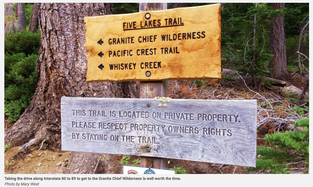
Every summer I used to take my sons up to Tahoe for a hike in the Granite Chief Wilderness in the Tahoe National Forest. We park at the trailhead near the Alpine Meadows Ski Resort to the Five-Lakes Trailhead. The first mile or so is uphill with a few switchbacks to get you up high to enjoy the panoramic views. Once up and into the wilderness area, enjoy the sweeping views of the surrounding mountains. To fit the scene, my sons will start to sing a song like the opening credits to an epic adventure movie. They will then laugh at me as I take 20 pictures of the same flower. The variety of rock formations and native plants will make you wish you were a botanist or geologist and could identify all that your eyes survey.
Taking the drive along Interstate 80 to 89 to get to the Granite Chief Wilderness is well worth the time. The natural beauty near and far is spectacular. From the wildflowers and towering trees covered in bright yellow/green lichen, to sweeping views on the canyons, everywhere you turn is a picture-worthy sight to behold. The Five-Lakes Trail connects to many other trails in the 19-thousand-plus acres of wilderness area. The trail continues around the ski resort, or you can connect to the Pacific Crest Trail to the west or south.
Taking 10 to 20 degrees off valley temperatures is the number one reason I hike up high in summer. The other is the trails are passable where they often are not with winter snow.


Five Lakes Trail is a 4.7-mile day hike. This is a heavily trafficked out and back trail. Dogs and horses are also welcome.
The lakes don’t offer much in the way of beach area, but you can usually find a log perfect to sit and enjoy the view. I would call the hike moderate. There are exposed areas, so sun protection is advised. There is brittle stone under foot in some areas that could be a slipping hazard. Quick moving thunderstorms are also common.


On one visit, my youngest son found a pine tree that had the most wonderful citrus scent, like an orange (Concolor Fir). What a great way to learn about the world around us firsthand.
Mary West is author of the book series Day Hiker – Gold Country Trail Guide I, II and III (2nd edition Available on Amazon). The books are a collection of the Day Hiker columns where West shares her longtime love of the outdoors, favorite hikes in Northern California’s Gold Country and beyond. West was the recipient of the 2017 and 2019 CRAFT Award for Best Outdoor Column and the 2020 Craft Award for her second book in the series-Day Hiker Gold Country Trail Guide by the Outdoor Writers of California. You can follow West on Facebook and Instagram

https://www.theunion.com/sports/outdoors/mary-west-exploring-granite-chief-wilderness-five-lakes-trail/

Walking with your dog — Head for the hills

7/16/2021

 
Picture
By Joan Merriam
Last month, I shared some ideas for walking with your dog in the lower-elevation areas of our region. Now that we’ve begun experiencing some of the sweltering days that summer can bring, let’s take a look at options for hikes in cooler, higher destinations.

Pioneer Trail
If you want to hike with your dog into the county’s more remote mountain region, you couldn’t ask for anything better than the Pioneer Trail. Beginning at the Harmony Ridge Market on Highway 20 across from the Wheelhouse, the trail parallels the highway all the way to White Cloud, where it crosses the road and heads well into the back country, down to Bear Valley, and eventually to Lake Spaulding. (A lesser-known route is the Harmony Trail, which takes off at the market and marches parallel to and below the Pioneer Trail for a few miles and then drops down into the Rock Creek watershed.) There are a number of spots further up Highway 20 where you can catch the trail, including the Conservation Camp turnoff, Lone Grave, White Cloud and Omega Road.

Hallelujah Trail
A little farther up Highway 20 is the Skillman Horse Camp, the starting point for this trail that’s part of an interconnected network that includes the Stanton, Big Tunnel, Omega, and Towle Mill trails, plus the Pioneer. Be aware that this is a multi-use route, which means that you’ll encounter everything from mountain bikers to horseback riders to joggers. The area includes more than 10 miles of trails, so bring along a picnic lunch!

Pacific Crest Trail
While you probably know that the Pacific Crest Trail runs from Mexico to the Canadian border, you may not know that it also traverses part of Nevada County. From Interstate 80 at Boreal, the trail crosses Donner Pass Road just east of Sugar Bowl and heads north-northeast into Sierra County, and south into Placer County. Since this trail traverses extremely wild and rugged country, much of it at elevations above 7,000 feet, be sure both you and your dog are in shape, and that you’re fully prepared with water and food. Go to the Pacific Crest Trail Association website at http://www.pct.org for detailed information and maps.

Mt. Judah/Donner Peak Trail
Another high-elevation hike offers some of the most breathtaking long-range views of Donner Lake you’ll ever find. The trail starts off with a nasty field of loose granite you need to traverse, and the last leg up to the top of Mt. Judah is very exposed and windy, but the rest of the hike is considered “moderate,” and the views are worth the struggle. It’s easily accessible from Interstate 80, just four miles from the Soda Springs exit.

Donner Rim Trail
Encircling Donner Lake itself is the Donner Lake Rim Trail, which eventually will run 23 miles from Truckee to Donner Summit. Fifteen miles of the trail are now complete, snaking through the forests of huge cedars and alongside massive granite boulders left from the last Ice Age. Along the way, you’ll find magnificent views of Donner Lake, Mount Rose and the Pacific Crest. This too is a very high-elevation hike, starting at 6500 feet and eventually reaching almost the 8000-foot level. Exit I-80 at the Donner Lake Interchange; on the north side of the freeway is a large dirt parking lot

Doggie Rules of the Road
No matter where you decide to go in our high country, keep in mind these “rules of the road:”

• Always bring plenty of water for both you and your pup
• Carry snacks like nuts, dried fruit, or granola bars that are nutritious, give you energy, and aren’t too filling. (And carry snacks for your dog, too!)
• If you’re hiking solo, tell someone where you’re going and when you’ll be back
• Bring along a first-aid kit just in case
• Keep your cell phone and a compass with you; it’s very easy to get lost or hurt in the back country
• Bring a leash, and obey trail rules about dogs on- or off-leash
• Leave no trace: leave what you find along the trail, and don’t leave your garbage for someone else to pick up
You can find information on more high-country trails in our area on Nevada County Gold, www.GoNevadaCounty.com, www.MotherLodeTrails.com, and the US Forest Service. To find hiking trails that are especially dog-friendly, go to DogTrekker.com.
​

See you on the hiking trail!

Joan Merriam lives in Nevada County with her Golden Retriever Joey, her Maine Coon cat Indy, and the abiding spirit of her beloved Golden Retriever Casey in whose memory this column is named. You can reach Joan at joan@joanmerriam.com. And if you’re looking for a Golden, be sure to check out Homeward Bound Golden Retriever Rescue

To see the original article and photos in The Union, CLICK HERE.


    Trail News

    Visit this page for all of the latest Trail News that affects our area.

    Archives

    January 2023
    November 2022
    October 2022
    September 2022
    August 2022
    July 2022
    June 2022
    April 2022
    March 2022
    January 2022
    November 2021
    October 2021
    August 2021
    July 2021
    June 2021
    May 2021
    April 2021
    March 2021
    February 2021
    January 2021
    December 2020
    November 2020
    October 2020
    September 2020
    August 2020
    July 2020
    June 2020
    May 2020
    April 2020
    March 2020
    February 2020
    January 2020
    December 2019
    November 2019
    October 2019
    September 2019
    August 2019
    July 2019
    June 2019
    May 2019
    April 2019
    March 2019
    February 2019
    January 2019
    December 2018
    November 2018
    October 2018
    September 2018
    August 2018
    July 2018
    June 2018
    May 2018
    April 2018
    March 2018
    February 2018
    January 2018
    December 2017
    November 2017
    October 2017
    September 2017
    August 2017
    July 2017
    June 2017
    May 2017
    April 2017
    March 2017
    February 2017
    January 2017
    December 2016
    November 2016
    October 2016
    September 2016
    August 2016
    July 2016
    June 2016
    May 2016
    April 2016
    March 2016
    February 2016
    January 2016
    December 2015
    November 2015
    October 2015
    September 2015
    August 2015

    Categories

    All

    RSS Feed

Home
Contact
 Mother Lode Trails is YOUR local volunteer-run trail information and resource website. Here you can find
up-to-the minute information on trail alerts, links and trail news for Placer,  Yuba, and Nevada counties.
Mother Lode Trails is trademarked.