American Canyon Trail is where the mushrooms grow in thick moss carpets along the creek in winter. The variety of butterflies and wildflowers are worth the four-mile hike in spring. The color display in fall makes a return trip a must.
The trail leads to a jungle like setting at the bottom with a flowing creek, boulders and hanging vines.
Wide enough for two to walk side by side, the trail is lush with ferns in winter and wild grape vines in summer. A thick area of mint, in its season, begs you to pick a leaf or two. Be aware that poison oak and blackberry vines crowd the trail in many areas. Snails and lizards also call this area home so make sure you look beneath your feet as well as up to the canopy of trees to get the full effect of this trail.
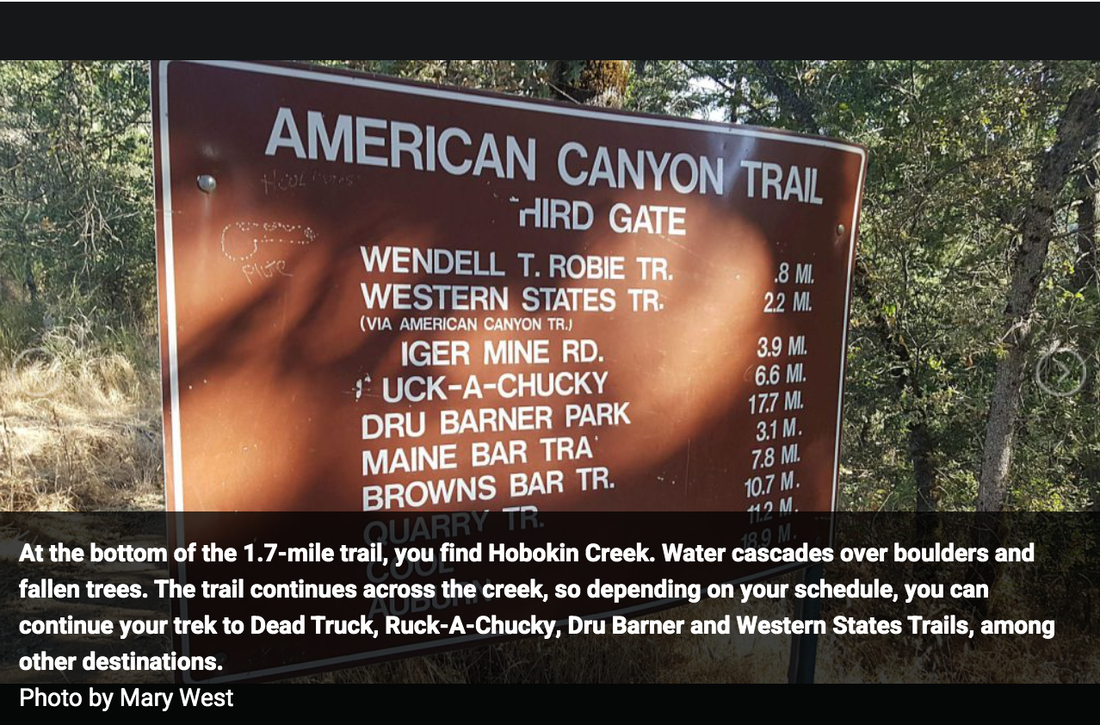
At the bottom of the 1.7-mile trail, you find Hobokin Creek. Water cascades over boulders and fallen trees. The trail continues across the creek, so depending on your schedule, you can continue your trek to Dead Truck, Ruck-A-Chucky, Dru Barner and Western States Trails, among other destinations.
The trail leads to a jungle like setting at the bottom with a flowing creek, boulders and hanging vines.
The two-mile hike to Dead Truck from the trail head is a gentle downhill stroll on a well-maintained trail. As you walk deeper in, the trees seem taller and vines hang more densely.
In winter the ferns grow all along the canyon wall. The moss on the trees is heavy with rainwater. You can hear the rush of the creek below.
At the first switchback, you find a sign reading several trail options. Turn away from the sign and continue down the switchback. After a couple of short switchbacks, you will come to a similar sign. Instead of turning on the switchback look at the sign straight ahead of you on the trail. This sign will show Dead Truck 1-mile. Your journey will continue deeper into the woods with the sound of Canyon Creek keeping you company along the way.
Soon you come to Canyon Creek with Hobokin Creek right behind it. I can in no way encourage you to cross these creeks if you do not feel confident doing so. This is a lovely spot to pull up a rock and listen to the gentle babbling of the creek over stones as it continues downstream.
The trail narrows in places. Downed trees and hanging branches may be hurdles along the way. Wet leaves and slick mud are also common hazards.
At 1.9-miles, you reach another sign, showing you at the foot of Dead Truck Trail marked STEEP.
Facing the sign, turn 180 degrees and you will see a footpath over to the creek and a cliff face blanketed in green in the wet season. Take the path and you can hear the falls get louder the closer you get. Shuffle down to the pool below. Again, I cannot suggest you cross the creek this last time, but the view of the falls is from the other side. When the water is low, there are exposed rocks, but with heavier flows, a crossing can be treacherous.
If you choose to cross you earn the prize of a view of the waterfall. Once you have enjoyed the falls, the pool and the peace and quiet of this trail, prepare for your return.
The two-mile hike out is moderate due to the uphill climb back to gate 3. Take your time, drink plenty of water, watch for slugs and newts in the wet season.
Take care crossing the creeks and before you know it, you will hear the cars coming into the gate and your adventure will be at its end.
To get to American Canyon Trail take Interstate 80 to the Elm Street exit in Auburn toward Placerville. Follow Highway 49 into the Canyon from Placer County into El Dorado County and out to the town of Cool.
At the stop sign in Cool turn left on Highway 193. Drive five miles to Pilgrim Way. Turn left to gate three of Auburn Lake Trails. Just before the gate you see room for three or four cars on your right. Park and you see the trail sign marking the trailhead.
----
Mary West is author of the book series Day Hiker – Gold Country Trail Guide. The books are a collection of the Day Hiker columns where West shares her longtime love of the outdoors, and favorite hikes in Northern California’s Gold Country and beyond. West was the recipient of the 2017 and 2019 CRAFT Award for Best Outdoor Column and the 2020 Craft Award for Day Hiker-Gold Country Trail Guide II by the Outdoor Writers of California. You can follow West on Facebook and Instagram.
CLICK HERE to see the complete article and all the photos in The Union newspaper.
The trail leads to a jungle like setting at the bottom with a flowing creek, boulders and hanging vines.
Wide enough for two to walk side by side, the trail is lush with ferns in winter and wild grape vines in summer. A thick area of mint, in its season, begs you to pick a leaf or two. Be aware that poison oak and blackberry vines crowd the trail in many areas. Snails and lizards also call this area home so make sure you look beneath your feet as well as up to the canopy of trees to get the full effect of this trail.
At the bottom of the 1.7-mile trail, you find Hobokin Creek. Water cascades over boulders and fallen trees. The trail continues across the creek, so depending on your schedule, you can continue your trek to Dead Truck, Ruck-A-Chucky, Dru Barner and Western States Trails, among other destinations.
The trail leads to a jungle like setting at the bottom with a flowing creek, boulders and hanging vines.
The two-mile hike to Dead Truck from the trail head is a gentle downhill stroll on a well-maintained trail. As you walk deeper in, the trees seem taller and vines hang more densely.
In winter the ferns grow all along the canyon wall. The moss on the trees is heavy with rainwater. You can hear the rush of the creek below.
At the first switchback, you find a sign reading several trail options. Turn away from the sign and continue down the switchback. After a couple of short switchbacks, you will come to a similar sign. Instead of turning on the switchback look at the sign straight ahead of you on the trail. This sign will show Dead Truck 1-mile. Your journey will continue deeper into the woods with the sound of Canyon Creek keeping you company along the way.
Soon you come to Canyon Creek with Hobokin Creek right behind it. I can in no way encourage you to cross these creeks if you do not feel confident doing so. This is a lovely spot to pull up a rock and listen to the gentle babbling of the creek over stones as it continues downstream.
The trail narrows in places. Downed trees and hanging branches may be hurdles along the way. Wet leaves and slick mud are also common hazards.
At 1.9-miles, you reach another sign, showing you at the foot of Dead Truck Trail marked STEEP.
Facing the sign, turn 180 degrees and you will see a footpath over to the creek and a cliff face blanketed in green in the wet season. Take the path and you can hear the falls get louder the closer you get. Shuffle down to the pool below. Again, I cannot suggest you cross the creek this last time, but the view of the falls is from the other side. When the water is low, there are exposed rocks, but with heavier flows, a crossing can be treacherous.
If you choose to cross you earn the prize of a view of the waterfall. Once you have enjoyed the falls, the pool and the peace and quiet of this trail, prepare for your return.
The two-mile hike out is moderate due to the uphill climb back to gate 3. Take your time, drink plenty of water, watch for slugs and newts in the wet season.
Take care crossing the creeks and before you know it, you will hear the cars coming into the gate and your adventure will be at its end.
To get to American Canyon Trail take Interstate 80 to the Elm Street exit in Auburn toward Placerville. Follow Highway 49 into the Canyon from Placer County into El Dorado County and out to the town of Cool.
At the stop sign in Cool turn left on Highway 193. Drive five miles to Pilgrim Way. Turn left to gate three of Auburn Lake Trails. Just before the gate you see room for three or four cars on your right. Park and you see the trail sign marking the trailhead.
----
Mary West is author of the book series Day Hiker – Gold Country Trail Guide. The books are a collection of the Day Hiker columns where West shares her longtime love of the outdoors, and favorite hikes in Northern California’s Gold Country and beyond. West was the recipient of the 2017 and 2019 CRAFT Award for Best Outdoor Column and the 2020 Craft Award for Day Hiker-Gold Country Trail Guide II by the Outdoor Writers of California. You can follow West on Facebook and Instagram.
CLICK HERE to see the complete article and all the photos in The Union newspaper.
 RSS Feed