MOTHER LODE TRAILS
  • Home
  • About
  • Contact
  • Volunteer
  • Links
    • Law Enforcement Emergency
    • Federal, State, County Districts Parks & Trails
    • Running Clubs
    • Equestrian Clubs
    • Mt. Bike Clubs
    • Hiking Clubs
    • Trail Advocacy Organizations
    • Phone Numbers State & Federal Parks, Trails & Lands
    • Where to Eat on the Trails
  • News
  • Alerts

High river flows expected through June, not safe to swim

4/27/2019

 
Picture
The sun is out and the seasons have quickly transitioned, meaning folks will be out wanting to escape the heat at one of their favorite local swimming holes. But those hoping to find peace and tranquility along the banks of the South Yuba River will be met with an abundance of dangerously frigid water. “We’re telling people that it’s really not safe to swim if you’re not familiar with the area,” South Yuba River Citizen’s League Community Engagement Manager Daniel Belshe said.

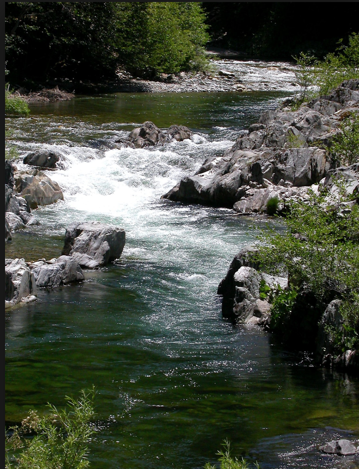
Dangerously high river flows along the South Yuba are expected through June and July. Right now, the Bureau of Land Management estimates a 167% above normal snowpack and have estimated a peak river flow for May 21.
“It’s actually higher than the average right now,” Belshe said. “So right now we’re sort of telling people to stay out of the water.”

Over 700,000 people visit the South Yuba River through the state parks river crossings at Bridgeport, Highway 49, Purdon, and Edwards Crossing each year and SYRCL is planning on ramping up its river ambassador program to help alleviate the impacts.

Now in it’s second year, the river ambassadors volunteer to help educate visitors about safe river recreation. “We were seeing a lot more trash over the year,” Belshe said. “There was a need for more of a presence at the river. We basically want to remind you to pick up your trash, no glass at the river, be fire safe, and the dangers of water safety right now with high waters, that’s one of our biggest talking points this year.” Despite warnings against entering the waters of the South Yuba River during high flows, Belshe and SYRCL staff still want people to get out there and enjoy the great outdoors.
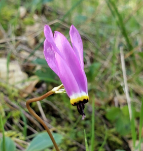
“There’s still so many things to do down there,” Beshe said. Thats what I’m trying to encourage, we still want people to go down there. It’s beautiful, hitting the trails down there, the wildflowers are blooming, the water is really pretty to look at, it’s flowing really hard and sounds beautiful, but be safe.”

To see the complete article and all photos in The Union Newspaper, CLICK HERE.

Day Hiker: Sweetwater Trail in Folsom Lake SRA

4/20/2019

 
Picture
Take a stroll along the lake in spring. Sweetwater Trail in the Folsom State Recreation Area is a 6+ mile out-and-back saunter along Sweetwater Creek, a tributary of Folsom Lake. Filled with wildflowers, rocks and views of the surrounding hills, the walk is a visual joy. This is a multi-use trail. Dogs are welcome on leash. 

Shooting Star (Dodecatheon pulchellum). Photo by Mary West​

I wanted to get out and hike this trail before the summer heat made it oppressive. There are shaded areas but take along sunblock, hat and glasses if you are sensitive to the sun. The poison oak was already shiny with oil in March. If you are sensitive to it, wear long sleeves and pants on this trail as it grows in profusion along the trail.

From Auburn take Highway 49 from Placer County to El Dorado County, toward Cool. Turn right on Rattlesnake Bar Road and take an immediate left on Salmon Falls Road. Follow Salmon Falls over the American River to the Salmon Falls Rafters Take Out parking lot on your left. The trailhead is just to the right of the restrooms. This is a fee area.

The highlight for me on this trail was the shooting stars. I have never seen them at this low elevation. I also enjoyed the patches of sage and mint along the way. After you make the trip to the far gate and start your return, consider the lower trail that runs along the wide creek. A bridge appears when the creek is low. Then cut up to the trail to return to the parking lot. 
​

Mary West is author of the book series “Day Hiker – Gold Country Trail Guide.” The books are a collection of the Day Hiker columns where West shares her longtime love of the outdoors and favorite hikes in Northern California’s Gold Country and beyond (Available on Amazon). You can follow West on Facebook and Instagram.

To see the complete article in the Mountain Democrat newspaper, CLICK HERE.


Tahoe Conservancy accepts $1.95 million grant to co-manage 2.4 million-acre Tahoe-Central Sierra Initiative

4/20/2019

 
Picture
Sacramento, Calif April 19, 2019 – At its Board meeting yesterday, the California Tahoe Conservancy (Conservancy) accepted a $1.95 million grant from the Sierra Nevada Conservancy (SNC) to co-manage the Tahoe-Central Sierra Initiative (TCSI), a pioneering landscape-level effort to restore forest and watershed resilience to more than 2.4 million acres.
“If we have learned nothing else from the recent wildfires in California, increasing our pace and scale of forest management is essential to protecting Tahoe and Central Sierra communities,” said Jeff Marsolais, forest supervisor for the U.S. Forest Service, Lake Tahoe Basin Management Unit, and ex officio member of the Conservancy Board. “Efforts funded by this grant will advance critical landscape-scale restoration.”
This Proposition 68 grant from the SNC will enable the Conservancy to provide strategic direction to forest health and watershed restoration across the entire TCSI landscape, which extends from the North Yuba River to the American River watershed, and encompasses the Lake Tahoe Basin. Conservancy staff will also plan restoration projects, coordinate restoration crews, and conduct research to speed up large-scale restoration.
The Conservancy and the SNC collaboratively lead the TCSI, along with 12 other partners including three National Forests. The TCSI partners have committed to:
  • restore resilience to the landscape using a science-based approach;
  • integrate research to guide development of climate and fire-resilient forests and fire-adapted communities;
  • accelerate planning, permitting, and implementation of high priority projects;
  • increase the use of resulting biomass and wood products; and
  • increase and leverage funding for large scale restoration.
To see the original article in YubaNet.net, CLICK HERE.

    Trail News

    Visit this page for all of the latest Trail News that affects our area.

    Archives

    February 2023
    January 2023
    November 2022
    October 2022
    September 2022
    August 2022
    July 2022
    June 2022
    April 2022
    March 2022
    January 2022
    November 2021
    October 2021
    August 2021
    July 2021
    June 2021
    May 2021
    April 2021
    March 2021
    February 2021
    January 2021
    December 2020
    November 2020
    October 2020
    September 2020
    August 2020
    July 2020
    June 2020
    May 2020
    April 2020
    March 2020
    February 2020
    January 2020
    December 2019
    November 2019
    October 2019
    September 2019
    August 2019
    July 2019
    June 2019
    May 2019
    April 2019
    March 2019
    February 2019
    January 2019
    December 2018
    November 2018
    October 2018
    September 2018
    August 2018
    July 2018
    June 2018
    May 2018
    April 2018
    March 2018
    February 2018
    January 2018
    December 2017
    November 2017
    October 2017
    September 2017
    August 2017
    July 2017
    June 2017
    May 2017
    April 2017
    March 2017
    February 2017
    January 2017
    December 2016
    November 2016
    October 2016
    September 2016
    August 2016
    July 2016
    June 2016
    May 2016
    April 2016
    March 2016
    February 2016
    January 2016
    December 2015
    November 2015
    October 2015
    September 2015
    August 2015

    Categories

    All

    RSS Feed

Home
Contact
 Mother Lode Trails is YOUR local volunteer-run trail information and resource website. Here you can find
up-to-the minute information on trail alerts, links and trail news for Placer,  Yuba, and Nevada counties.
Mother Lode Trails is trademarked.