MOTHER LODE TRAILS
  • Home
  • About
  • Contact
  • Volunteer
  • Links
    • Law Enforcement Emergency
    • Federal, State, County Districts Parks & Trails
    • Running Clubs
    • Equestrian Clubs
    • Mt. Bike Clubs
    • Hiking Clubs
    • Trail Advocacy Organizations
    • Phone Numbers State & Federal Parks, Trails & Lands
    • Where to Eat on the Trails
  • News
  • Alerts

New Forest Supervisor selected for Lake Tahoe Basin

10/24/2020

 
Picture
SOUTH LAKE TAHOE, Calif., Oct. 23, 2020 –
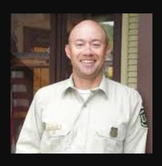
​The USDA Forest Service Lake Tahoe Basin Management Unit (LTBMU) is pleased to announce that William “Bill” Jackson has been selected as the new Forest Supervisor for the Lake Tahoe Basin. Jackson is scheduled to arrive at the LTBMU on Dec. 6, 2020, and comes to us from the White River National Forest in Colorado, where he served as the District Ranger for the Dillon Ranger District. 
“I’m excited to share the news that we have selected a new Forest Supervisor for the Tahoe Basin,” said Acting Forest Supervisor, Danelle D. Harrison. “Bill has an extensive background in land management, and I can’t think of anyone better qualified to lead our Forest Family.”
Prior to his position on the Dillon Ranger District, Jackson served as the District Ranger for the Manchester Ranger District on the Green Mountain National Forest in Vermont. He also served on the Pike, San Isabel, Grand Mesa Uncompahgre and Gunnison National Forests and Cimarron and Comanche National Grasslands.
Jackson earned a Natural Resource Management degree from North Carolina State and joined the Peace Corps in Honduras for two years, where he helped promote ecotourism and environmental education. After the Peace Corps, he attended graduate school at Colorado State University, where he studied natural resource management, recreation and tourism.
Jackson replaces Jeff Marsolais who accepted a position with the Eldorado National Forest in mid-June 2020.

Contact(s): Public Affairs, Lisa Herron 530-721-3898

To see original press release from the USFS, click here.


Exploring the Old Flume Trail

10/24/2020

 
Picture
The Old Flume Trail (Red Shack Trail) just outside of Placerville in El Dorado County is a history lesson as well as an excellent trek to the South Fork of the American River. The trail has been there since its inception in 1900, of course, but the new parking area built by the Bureau of Land Management makes parking safer, and access easier.

The trail was a road to the river. This road crosses the historic ditch that moved water from Placerville to the ranches in the Gold Hill area. You can read about George and John Luce who managed the flume from 1920 to 1924. The wooden flume is believed to be the tallest in the county at 153 feet and running 750 feet between the ridges. The flume is gone, but the land was gifted to the American River Conservancy in 1999 for our enjoyment.

The trail is wide, but I would call this moderate to difficult depending on your fitness level due to the steep drop into the canyon — about 800 feet in less than a mile. Worth every step when you find yourself rock hopping out to a quiet location just below Racehouse Bend rapid on the South Fork.
It took me a half hour to get from the parking lot to the river. I stopped to check out some spur trails along the way. But it took me nearly an hour to return to the parking lot due to the steep grade. Take your time, take breaks if needed and drink plenty of water.

The trail is wide, but I would call this moderate to difficult depending on your fitness level due to the steep drop into the canyon — about 800 feet in less than a mile. Worth every step when you find yourself rock hopping out to a quiet location just below Racehouse Bend rapid on the South Fork.
This is a beautiful in an out trail, less than a mile one way, with a stunning payoff at the halfway point. My most recent hike on a cool and sunny day showed off the lush moss on the trees as green ferns unfurled along the canyon walls and a couple of kayakers floating by.
​
To get there from Auburn head out on Highway 49 South toward Cool. Continue toward Placerville. As you make your way through the canyon, about four miles north of Placerville, look for Red Shack Road on the right. The trail head is directly across the street. Red Shack is a nice stop after your adventure for pulled pork sandwiches or apple pie when open.
----------------
Mary West is author of the book series Day Hiker – The Gold Country Trail Guides. A collection of Day Hiker columns from 2016-2020 (Available on Amazon) where West shares her longtime love of the outdoors, and favorite hikes in Northern California’s Gold Country and beyond. West was the recipient of the 2017 and 2019 CRAFT Award for Best Outdoor Column by the Outdoor Writers of California. You can follow West on Facebook and Instagram.

CLICK HERE to see the complete article in The Union newspaper.

​

Southern Cross Preserve finds its forever home with Tahoe National Forest

10/15/2020

 
Picture
From Bear Yuba Land Trust today, "We’re happy to announce that Southern Cross Preserve has been transferred to US Forest Service ownership, where it will join the rest of the Tahoe National Forest! This beautiful preserve is located on the North Fork American River. The public Euchre Bar Trail runs through the property and provides excellent views of the river. 

If you look at a map of the Tahoe National Forest, you’ll notice that it looks like a “checkerboard” of public and private property. This unusual pattern has its roots in 19th-century federal land policy and the construction of the Union Pacific Railroad north of Lake Tahoe. The resulting “patchwork quilt” of public and private lands can create challenges for land management and public recreation. By permanently protecting private lands within the “checkerboard” and transferring them to the USFS, we can help expand the Tahoe National Forest and fill in the gaps. 

“This project was especially cool because it's a great model — we work with the landowner to secure a complex land deal, then transfer it to public ownership,” says Placer Land Trust Conservation Director Lynnette Batt. “It adds more land to the Tahoe National Forest, which is a popular and important landscape in the Sierra. And importantly, selling land to the USFS allows us to cover our costs, and to ‘pay it forward’ to our future land protection projects. We are grateful to the USFS for being great partners.”

To learn more about Southern Cross Preserve and this transfer project with USFS, CLICK HERE.

Mary West: Hiking Loch Leven Trail

10/11/2020

 
Picture
Loch Leven Trail is a moderate to difficult hike with more than a one thousand-foot elevation change over a 3.5-mile trail to the first lake in the Loch Leven chain of lakes in the Tahoe National Forest.
To get there take Interstate 80 east to the Rainbow Bend exit. Take a left onto Hampshire Rocks Road. Drive up just past the Tahoe National Forest fire station to the trailhead parking lot. An information board and restrooms are located here. The sign marking the trailhead is directly across the street.

The trail begins with granite boulders. Under foot are rocks, roots, ruts, sand, decomposed granite and decomposed trees. Wear sturdy shoes and take those trekking poles they may come in handy.
Around you are boulders, colossal pine trees, views of surrounding mountain peaks, and the lakes. One very prominent peak is Red Mountain, also known as Signal Peak. The first landmark are the railroad tracks. Other highlights of the trail include the yellow aspen in fall. You skirt a pond that is more of a bog by September until the rains return. A wooden bridge leads into a cool shaded area briefly before the climb continues. Level areas give you a chance to catch your breath before forging on. A few of the volunteer trails can lead you astray. Stay on track. Other highlights of the trail include the yellow aspen in fall. You skirt a pond that is more of a bog by September until the rains return.

Once you reach the lake, find your spot to settle in and get your shoes off, a snack will be in order. If you have time and the inclination, more lakes await you as well as Cherry Peak trail three miles out from the trailhead. The great thing about Loch Leven Trail is that the return trip to the trail head is mostly downhill.

​Loch Leven Trail is a moderately trafficked trail and dogs are welcome. Take plenty of water. Plenty of sun exposure on this trail so you may want a hat, glasses and sunblock.

Mary West is author of the book series Day Hiker – Gold Country Trail Guides (Available on Amazon). The books are a collection of the Day Hiker columns where West shares her longtime love of the outdoors, and favorite hikes in Northern California’s Gold Country and beyond. West was the recipient of the 2018 and 2019 CRAFT Award for Best Outdoor Column by the Outdoor Writers of California. You can follow West on Facebook and Instagram.

To read the original article and see photos in The Union newspaper, CLICK HERE.

Picture

    Trail News

    Visit this page for all of the latest Trail News that affects our area.

    Archives

    February 2023
    January 2023
    November 2022
    October 2022
    September 2022
    August 2022
    July 2022
    June 2022
    April 2022
    March 2022
    January 2022
    November 2021
    October 2021
    August 2021
    July 2021
    June 2021
    May 2021
    April 2021
    March 2021
    February 2021
    January 2021
    December 2020
    November 2020
    October 2020
    September 2020
    August 2020
    July 2020
    June 2020
    May 2020
    April 2020
    March 2020
    February 2020
    January 2020
    December 2019
    November 2019
    October 2019
    September 2019
    August 2019
    July 2019
    June 2019
    May 2019
    April 2019
    March 2019
    February 2019
    January 2019
    December 2018
    November 2018
    October 2018
    September 2018
    August 2018
    July 2018
    June 2018
    May 2018
    April 2018
    March 2018
    February 2018
    January 2018
    December 2017
    November 2017
    October 2017
    September 2017
    August 2017
    July 2017
    June 2017
    May 2017
    April 2017
    March 2017
    February 2017
    January 2017
    December 2016
    November 2016
    October 2016
    September 2016
    August 2016
    July 2016
    June 2016
    May 2016
    April 2016
    March 2016
    February 2016
    January 2016
    December 2015
    November 2015
    October 2015
    September 2015
    August 2015

    Categories

    All

    RSS Feed

Home
Contact
 Mother Lode Trails is YOUR local volunteer-run trail information and resource website. Here you can find
up-to-the minute information on trail alerts, links and trail news for Placer,  Yuba, and Nevada counties.
Mother Lode Trails is trademarked.