MOTHER LODE TRAILS
  • Home
  • About
  • Contact
  • Volunteer
  • Links
    • Law Enforcement Emergency
    • Federal, State, County Districts Parks & Trails
    • Running Clubs
    • Equestrian Clubs
    • Mt. Bike Clubs
    • Hiking Clubs
    • Trail Advocacy Organizations
    • Phone Numbers State & Federal Parks, Trails & Lands
    • Lost & Found on the Trails
    • Where to Eat on the Trails
  • News
  • Alerts

Bear River Recreation Area: a hidden gem

8/23/2018

 
Picture
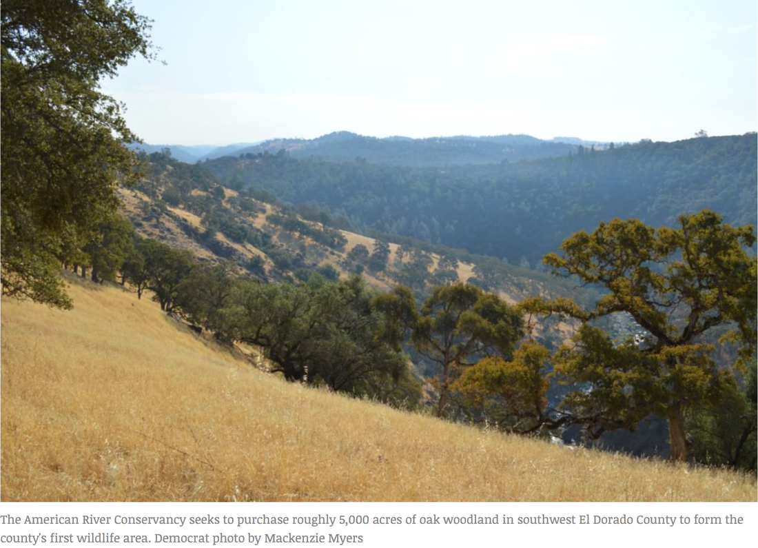
Hidden in a lovely canyon running along the Nevada and Placer County borders, the Bear River Recreation Area, between Rollins and Combie Reservoirs, is a little known gem for families and river lovers seeking quiet river recreation.
​Photo credit: Gary Moon

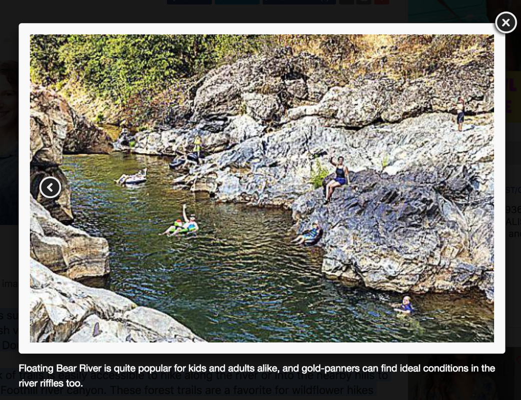
There are easy access points near Colfax and Grass Valley and Bear River offers places to hike, fish, pan for gold, swim, picnic, camp and go tubing on the river.

There is free day use parking and access to 250 acres of parkland is the Bear River Park and Campground, with access from Colfax off Milk Ranch or Plum Tree Roads. This spot has a wide, cobble stone beach area with plenty of room to spread out and enjoy a day relaxing on the river.

Steep forested slopes surround the recreation and camping areas, and the Bear runs through a diverse ecology of lush vegetation from willows and alders at the river's edge to towering Ponderosa pines and Douglas firs.

A maintained network of trails is easily accessible to hike along the river or into the nearby hills to experience a healthy Foothill river canyon. These forest trails are a favorite for wildflower hikes and bird watching.

Hikers encounter an abundance of wildflowers including trillium, fairy lanterns, Humboldt lily, bleeding heart, and shrubs such as manzanita, ceanothus, California buckeye, and elderberry. A mature oak woodland shades much of the area with Canyon live oak, Interior live oak and black oaks; many are especially gigantic and very old.

Wildlife abounds in this riparian oasis and visitors will see a wide variety of birds, including seasonal song birds such as Black-headed and Evening Grosbeaks, colorful Western Tanagers, and an assortment of warblers. Keep an eye out for deer, bear, coyote, raccoon, the shy nocturnal Ringtail cat, and Bobcat.

Bear River's currents have a range of personalities. In the spring, advanced kayakers skilled in class 4 and 5 rapids like the stretch of river from the Highway 174 bridge to Ben Taylor Road, or the mellower and longer class 2 run to Lake Combie. In the later season, inner tubers can run from the Colfax access all the way to the Dog Bar Bridge. Gold-panners find ideal conditions in the Bear's riffles, too.

For easy access, park next to the Bear where Highway 174 crosses into Placer County. Head out under the bridge onto the trail on the Nevada County side of the river. The trail winds over a mile along the river past well-known swimming and fishing holes.

Dog Bar Road crosses the Bear farther south in Nevada County, providing good access. From there, hike upriver to Duck's Bill — a classic jumping spot into a refreshingly clear pool. On this mellow stretch, the day can end with a swim the half mile back to the car.
​
The Bear River is often overshadowed by the nearby Yuba and American river systems. But the gentle Bear has family-friendly, local access and great recreation opportunities for the whole family.

CLICK HERE to see the original article and more photos in The Union newspaper.

ARC raising funds for El Dorado County’s first wildlife area

8/22/2018

 
Picture
In order to purchase land for El Dorado County’s first wildlife area, which will include recreational trails, the American River Conservancy is searching for $200,000 by the end of September.

The ARC aims to purchase two properties — the 1,737-acre Ervin Ranch and a 3,157-acre portion of the El Dorado Ranch — both near the Cosumnes River west of Highway 49. The ranches have a combined price tag of $4.68 million, but 96 percent of the costs have been secured so far. The remaining 4 percent, or $200,000, is needed before escrow closes late next month. 
​
According to an appeal letter from the conservancy, they seek to protect this area in particular because the Cosumnes River is “one of the last undammed rivers on the west slope of the Sierra Nevada.”
ARC director Alan Ehrgott said the river has historically provided a run for Chinook salmon and central valley steelhead, which currently spawn below Latrobe Falls. The properties total just over 3 miles of riverfront and riparian area. If purchased, the ranch land would connect already-purchased pieces to form 5,000 acres of wildlife habitat, Ehrgott said Monday, adding that this area would be the largest contiguous blue oak woodland in the central northern Sierra region. 
Fauna like the Western pond turtle, bald eagles, golden eagles and an extensive list of other species also call the ranch area home.

If the land is purchased, it will eventually include trails for horseback riding, mountain biking and hiking, Ehrgott said, though the installation process will take two or three years. The conservancy would like to put in a trail reaching from Highway 49 down to Latrobe Road, he said, though the decision ultimately falls upon the California Department of Fish and Wildlife, which will own and manage the land.

An 1860s historic ranch is also on the property, with a barn, a house, fences and rock walls still standing. Ehrgott anticipated these sites would be left within the wildlife area.

Though the El Dorado Ranch is used today to graze cattle, Ehrgott said it was acquired by a developer in 1989 who wished to turn it into a subdivision named Cinnabar. The controversial project ran into hangups, including an Amador County lawsuit and environmental reports that identified archaeological resources. The project never came to fruition before the developer passed away and the property was sold to its current owner.

As for whether the conservancy plans to hold any more fundraisers to reach their $200,000 goal, Ehrgott said they’ve turned over every rock they could and are now counting on generosity from community members. Historically, he said, the conservancy has managed to eke out those last few dollars and close the deal on an acquisition. Sometimes donations are hundreds of thousands of dollars, but many are contributions of around $20, Ehrgott said. 
“We’re close, we’re within 4 percent of our purchase price and we have about two months,” Ehrgott said Friday, “so we’re just kind of doing the best we can, rolling up our sleeves and digging in.”

The bulk of support secured so far comes from a $2.5 million State Wildlife Conservation Board grant and $850,000 from the California Natural Resources Agency. Ehrgott said the landowner pitched in a $500,000 discount on the property. $500,000 more came from the California Wildlife Foundation, while the El Dorado County Oak Woodland Program and the ARC itself contributed $63,250 and $66,750 respectively.
​
Those interested in donating can do so online at www.arconservancy.org or by mailing checks to the American River Conservancy, P.O. Box 562, Coloma, CA 95613. 

Photo Credit:  Mackensie Myers.

CLICK HERE to see the original article and photos in the Mountain Democrat newspaper.
Picture

Pines to Mines Trail: 80-mile trail will link towns of Truckee and Nevada City

8/10/2018

 
Picture
Trout Creek Canyon, Donner Lake Rim, Hole-in-the-Ground, Spaulding Lake, and Pioneer Trails, are a few of the high elevation trails destined to be connected by a new 80-mile trail linking Truckee to Nevada City called the Pines to Mines Trail.
This trail will encompass the best the county has to offer: Jaw-dropping views of sweeping valleys and the Sierra Crest, mature mixed conifer forests, historic towns, and high quality recreation.
Now in the design phase, this legacy trail will offer both single and multi-day excursions by creating a series of smaller loops and point-to-point routes. With its long distance, varied terrain, unique habitats and majestic views, the trail has the potential to become a regional and national draw.
Already considered destination hubs, the communities of Truckee in the East and sister cities Nevada City and Grass Valley in the West were recently named among 14 California Cultural Districts in a new state program dedicated to showcasing cultural diversity and unique artistic identities. The towns are known for quality lodging, boutiques, restaurants, cafes, coffee shops, breweries, wineries and a thriving arts and music culture.
Improving the quality of non-motorized trails that connect the sister cities with Truckee will further draw outdoor recreationists to the region while connecting east and west sides of the county that historically seemed worlds apart.
"I see the new trail as a creation that will allow non-motorized access into an iconic, stunningly beautiful backcountry where there is currently only poor quality access — horribly eroded Jeep roads, dusty forest roads and bushwhacking rough country," said Jane Ragan of Bicyclists of Nevada County. "We're imagining riding and walking on a beautiful winding trail alongside Old Man Mountain, crystalline lakes and the wonderful world of big trees and granite."
RECOMMENDED STORIES FOR YOUEric Little: California’s privacy gamble

Pair linked to theft of prosthetic arm back in Nevada County Jail, authorities say

Kidnap, robbery trial postponed again, plea agreement possible for two Nevada County suspects

Law enforcement officers find thousands of cannabis plants, environmental damage in foothills


TAPPING INTO NATURE
Many people drive through Western Nevada County to travel to Downieville in Sierra County or Lake Tahoe. Regional trail advocates say it's time to start tapping into and capturing some of that traffic by giving outdoors people a reason to stay and play in Nevada County. Nevada City and Truckee are positioned adjacent to hundreds of acres of public forest and prime recreation lands. Close to major transportation corridors — Interstate 80 and the Reno and Sacramento airports — Nevada County is easily accessible from anywhere in the country.
"Easy access to good trails enhances our quality of life, and well-designed, interesting routes can spur economic activity by attracting visitors, as places like Moab, Utah, and even Sierra County next door have learned to their benefit," said District 5 County Supervisor Richard Anderson, who spearheaded the Pines to Mines Trail Alliance in 2015 and subsequent series of stakeholder meetings.
Currently, the alliance is made up of Bear Yuba Land Trust, Bicyclists of Nevada County, Gold Country Trails Council and Truckee Trails Foundation. A capable and committed constituency has formed around the project to seek and administer funding, create a sustainable trail alignment on the ground, provide trail building expertise, exercise land management, and perform ongoing trail maintenance and support going forward.
The group envisions a non-motorized multi-use earthen trail crossing Nevada County's most beautiful landscapes providing a rugged backcountry experience for hikers, runners, mountain bicyclists and equestrian riders. When completed, the 80-mile trail will utilize existing trail segments and approximately 14 miles of newly constructed trail.
"Think of the majestic views of the Sierra Crest from the Donner Lake Rim Trail, Castle Peak from Andesite, Old Man Mountain and the realm of granite in the Fordyce Creek and South Yuba River drainages, Bear Valley from the Pioneer Trail lookout, immense trees along the Pioneer Trail, a National Scenic Trail, bookended by town breweries and restaurants," said Jane Ragan.

    Trail News

    Visit this page for all of the latest Trail News that affects our area.

    Archives

    January 2023
    November 2022
    October 2022
    September 2022
    August 2022
    July 2022
    June 2022
    April 2022
    March 2022
    January 2022
    November 2021
    October 2021
    August 2021
    July 2021
    June 2021
    May 2021
    April 2021
    March 2021
    February 2021
    January 2021
    December 2020
    November 2020
    October 2020
    September 2020
    August 2020
    July 2020
    June 2020
    May 2020
    April 2020
    March 2020
    February 2020
    January 2020
    December 2019
    November 2019
    October 2019
    September 2019
    August 2019
    July 2019
    June 2019
    May 2019
    April 2019
    March 2019
    February 2019
    January 2019
    December 2018
    November 2018
    October 2018
    September 2018
    August 2018
    July 2018
    June 2018
    May 2018
    April 2018
    March 2018
    February 2018
    January 2018
    December 2017
    November 2017
    October 2017
    September 2017
    August 2017
    July 2017
    June 2017
    May 2017
    April 2017
    March 2017
    February 2017
    January 2017
    December 2016
    November 2016
    October 2016
    September 2016
    August 2016
    July 2016
    June 2016
    May 2016
    April 2016
    March 2016
    February 2016
    January 2016
    December 2015
    November 2015
    October 2015
    September 2015
    August 2015

    Categories

    All

    RSS Feed

Home
Contact
 Mother Lode Trails is YOUR local volunteer-run trail information and resource website. Here you can find
up-to-the minute information on trail alerts, links and trail news for Placer,  Yuba, and Nevada counties.
Mother Lode Trails is trademarked.