MOTHER LODE TRAILS
  • Home
  • About
  • Contact
  • Donations
  • Volunteer
  • Links
    • Law Enforcement Emergency
    • Federal, State, County Districts Parks & Trails
    • Running Clubs
    • Equestrian Clubs
    • Mt. Bike Clubs
    • Hiking Clubs
    • Trail Advocacy Organizations
    • Phone Numbers State & Federal Parks, Trails & Lands
    • Lost & Found on the Trails
    • Where to Eat on the Trails
  • News
  • Alerts

Balancing Trail Access and Safety in East Bay Parks

2/25/2021

 
Picture
One of the greatest joys of living in the East Bay is hiking the trails in the many parks of the East Bay Regional Park District. The COVID-19 pandemic has revealed how vital and important the park system is for people’s physical and mental health. In addition to hikers, mobility-challenged users in wheelchairs, joggers, dog-walkers, equestrians, mountain bikers, and electric-bike riders also enjoy the trails. As stakeholders of this public park system, we have to think about how we can ensure access for all park users while protecting public safety, wildlife, and sensitive habitats. 

​The Park District has both narrow trails, generally under 8 feet in width, and wider trails, which are usually old ranch roads or fire roads. In the early 1980’s, the Park District opened up the wider trails to mountain bikes. This gave mountain bikers access to 80% of all trails. In addition, in the early 2000’s, the Park District created a pump trail system within the Crockett Hills Regional Park specifically for mountain bikers (while nominally being posted and available for hiking and equestrian use, too). Meanwhile, through the Park District’s Ordinance 38 process, 30 narrow trails have been opened up for mountain bikers. 

According to the Park District’s own survey data, 82 to 88% of trail users are pedestrians or hikers, 10 to 12% are mountain bikers, and 5% are equestrians. "The survey data also showed that 80 to 90% of trail users favored trails dedicated to pedestrian and equestrian users."

Currently, the East Bay Regional Park District is engaged in a process for evaluating how to manage user access on their narrow trails. This process takes place in the context of  the mountain biking community’s call for the opening up of more narrow trails to mountain bikes, and the Park District’s recent announcement that all new narrow trails will be designed and constructed for all users. The Park District has also proposed allowing mountain bikes on existing narrow trails that are primarily used by the large population of pedestrians, as well as equestrians. That proposal would result in a significant change to the trail experience of the District's 25 million annual park users. 

The “narrow multi-use trails for all” concept raises significant issues. Ample evidence from past experience, both from within the Park District and from other park agencies, illustrates that narrow trails designed primarily for bicycles result in hikers and equestrians avoiding those trails. Likewise, a group of people walking or riding on a narrow trail is often a frustrating experience for a mountain biker who has built up speed going downhill.

The diagram to the right shows just how tight the situation can become on a narrow trail.
Beginning in 2017, the Sierra Club asked the Park District to create a facilitated workshop of various user groups to see if a consensus could be reached on these issues. Finally, in 2020 the Park Board created the Trails Users Working Group (TUWG).

To examine this issue, we ask that the Trail Users Working Group provide or address:
  • Baseline data on the District’s trail user populations by different interests, trail access by trail miles, trail accident data, trail complaint data, enforcement responses, mapped locations of unopened park properties, and baseline analysis of wildlife and habitat in and adjacent to a proposed route for any narrow trail no matter what users will ultimately be allowed;
  • District capacity in place to manage expansion of certain trail uses, including controlling and restoring informal/rogue trails, trail repairs, trail accidents, and enforcement demands within the existing park management demands on operations staff;
  • For the “multi-use narrow trails for all” proposal, including the observable impacts of combining all users on narrow trails. What impacts are there on a trail user’s desire for a contemplative experience (communing with nature rather than worrying about whether a mountain bike is barreling down the trail), birdwatching, observations of other wildlife and plant life;
  • E-bike growth: Develop scenarios for managing impacts from the growing presence of e-bikes on park trails where they are not permitted (e-bikes are allowed only on select park trails). 
  • Trail policy alternatives that will result in constructive solutions that protect the parks' biodiversity and preserve enjoyable and positive experiences for all trail users.
The "narrow trails for all" proposal that is being floated for all narrow-width trails constructed in the future has yet to be fully evaluated in a public forum. The thirty-one members of the TUWG can help craft solutions. 

You can read the Sierra Club white paper on trail issues here. 

Members can also let the Park District Board and staff know of their concerns and can copy the Sierra Club’s East Bay Public Lands Committee with their concerns. You can send a letter to their mailing address below, or use their online contact form.

East Bay Regional Parks District 
2950 Peralta Oaks Court
P.O. Box 5381
Oakland, CA 94605-0381 

If you want to learn more about the work of the East Bay Public Lands Committee, contact committee chair Norman La Force at n.laforce@comcast.net. 

CLICK HERE TO SEE ORIGINAL ARTICLE IN THE SIERRA CLUB NEWSLETTER.


Rusty, the California State Parks Mounted Patrol horse, wrote a book!

2/17/2021

 
Picture
Eric Luhrs is a retired mounted police officer from California. He was assigned to the mounted unit from 1987 to 2009 and is a state certified mounted police instructor. Rusty and Eric worked as a team during routine patrol, crowd control, parade events, and school presentations in Sacramento, California. His horse, Rusty, has written a book and has a Facebook page, "A Day in the Life of Rusty the Police Horse." CLICK HERE TO VISIT AND LIKE RUSTY'S FACEBOOK PAGE. 

"HIs book is an illustrated children's story that shares a typical day in the life of a police horse and offers valuable lessons for young readers.
Rusty is a police horse, and he is very proud to be one. He is eager and ready to perform his duties and knows that he does his best every day.
Rusty begins his day with a good breakfast. After that, the real fun begins. He likes to train, which helps him be brave, and to keep clean. He goes out on patrol, where he loves to greet people - especially children! On special days he marches in parades, which is very exciting. Although sometimes the sights and sounds of the city may scare Rusty, he knows he must face his fears with courage and confidence. His job is very important! What's more, he has important advice to help everyone do their best everyday."


CLICK HERE to visit Rusty's webpage!
To order a copy, email  Eric here: 
luhrseric@yahoo.com


Picture

Mary West: Exploring the El Dorado Trail around Placerville

2/13/2021

 
Picture
The El Dorado Trail system is 35-miles of hiking, equestrian and biking trail in and around Placerville, but much of it is paved and not your typical wild land hike.
The trail has grown over the years, with new additions now stretching from Camino to the El Dorado and Sacramento County line. Much of it is paved. Several access points or trailheads mean you can experience different parts of the trail depending on your schedule.

I have accessed the trail from three different trailheads. The first was my favorite.
I call this WUI hiking. WUI stands for Wildland Urban Interface. This isn’t exactly urban hiking but it isn’t the wild and rugged trails we know and love in the wilderness. This is a paved 3.1 mile walk just outside of town off Missouri Flat Road in Placerville. It took me some time to find the trailhead. Let me save you the trouble. Go to Sierra Door and Supply. Drive right to the business as if you were a customer. At the end of the parking lot look for another parking lot with what looks like a split rail fence. You will see the signs for the trailhead. Park in this lot. The pedestrian/bike path with two lanes takes you past some ranch land and past homes before you get to, what I think is the highpoint of this trail; a repurposed train trestle with a bridge over Weber Creek.
The wooden bridge is screened with metal fencing. The fence is adorned with a number of locks. The locks express the romantic gesture of couples showing their bond to one another. In many cases the key to the lock that symbolizes the happy couple’s commitment is thrown over the edge into the river below.
This is a family friendly and dog friendly trail. My sons enjoyed the exercise stations along the trail, including pull up bars and sit up benches. The trail ends at 3.1 miles at the back of the Sheriff’s station making for a 6.2 mile out and back walk, jog or ride.
If you head the other way, behind Walmart, you are exposed to the various homeless camps in and around the industrial area.
Several roads lead to Placerville. You can take Highway 49 to Highway 50. Turn right and head down the hill to Missouri Flat Road. Take a left back over the freeway and out Missouri Flat Road to Sierra Door and Supply. Do not park in the business parking lot. Park at the trailhead. If there is no parking available go across the street to Walmart.
Another access point is off Mosquito Road across the street from the bus station. It runs along the back of homes and features a tunnel.
The third portion I have hiked begins off Carson Road, off Jacquire on Amelia Lane. This portion leads to a bridge over highway 50. It’s loud along the highway.
Mary West is author of the book series Day Hiker – Gold Country Trail Guide I, II and III (Available on Amazon). The books are a collection of the Day Hiker columns where West shares her longtime love of the outdoors, favorite hikes in Northern California’s Gold Country and beyond. West was the recipient of the 2017 and 2019 CRAFT Award for Best Outdoor Column and the 2020 Craft Award for her second book in the series-Day Hiker Gold Country Trail Guide by the Outdoor Writers of California. You can follow West on Facebook and Instagram.

CLICK HERE to see the original article and more photos in The Union newspaper.


Interior Announces Plans to Strengthen Land and Water Conservation Fund (LWCF)

2/12/2021

 
Picture
WASHINGTON — The Interior Department today took steps to strengthen the Land and Water Conservation Fund (LWCF) by rescinding Trump administration policies that significantly undermined the landmark conservation program. 
Secretarial Order 3396 revokes an order signed on November 9, 2020 that unilaterally imposed new restrictions to inhibit the availability of LWCF funding for federal land and water acquisitions. 
 
“The Land and Water Conservation Fund has been crucial to protecting public lands, conserving wildlife habitats, and improving access to outdoor recreation. Interior’s actions today affirm our support for one of America’s most successful and popular conservation programs,” said Shannon A. Estenoz, Principal Deputy Assistant Secretary - Fish and Wildlife and Parks. “We look forward to further strengthening this successful program to ensure that all communities – from hikers and sportsmen to urban and underserved communities – have access to nature and the great outdoors.”  
 
In addition to rescinding the November 2020 Bernhardt policy, Secretarial Order 3396 instructs the National Park Service to revise the Land and Water Conservation Fund Assistance Manual to remove the restrictive policies implemented in the previous order, and to reinstate pre-existing implementation of the LWCF state assistance program and Outdoor Recreation Legacy Partnership (ORLP) program. The ORLP program is the only LWCF competitive grant program dedicated to addressing the  recreational  gap in underserved urban areas.  
 
Since its inception in 1965, the LWCF has funded $4 billion worth of projects in every county in the country. Last year, Congress permanently funded the LWCF at $900 million per year with wide bipartisan support. At no cost to taxpayers, the LWCF supports increased public access to and protection for federal public lands and waters – including national parks, forests, wildlife refuges, and recreation areas – and provides matching grants to state and tribal governments for the acquisition and development of public parks and other outdoor recreation sites.   
​

The new, larger CCC in the works under Biden administration

2/10/2021

 
Picture
Biden's new conservation corps stirs hopes of nature-focused hiring spreeAfter Biden’s omnibus executive order, the heads of the Department of the Interior, the Department of Agriculture and other departments have 90 days to present their plan to “mobilize the next generation of conservation and resilience workers”, a step toward fulfilling Biden’s promise to get the US on track to conserve 30% of lands and oceans by 2030. Projects will include working to mitigate wildfire risks, protect watershed health, and improve outdoor recreation access.
Photo Credit: a group of teenage boys roll a log across a clearing at the CCC camp in Redwood State Park. 
Photograph: Bettmann/Bettmann Archive


​Nearly a century ago, the US faced unemployment at 25% and environmental woes such as flooding along major rivers and extensive deforestation. President Franklin Delano Roosevelt decided to tackle these emergencies simultaneously by creating the Civilian Conservation Corps (CCC) as part of his New Deal.

Through its nine-year existence, Roosevelt’s “Tree Army” put an impressive 3 million jobless Americans to work. All in all, CCC enrollees planted more than 3bn trees, paved 125,000 miles of roadways, erected 3,000 fire lookouts, and spent 6m workdays fighting forest fires.

The artifacts from this ambitious effort – such as trails and structures dotting the Grand Canyon national park or the Pacific Coast Trail – are beloved today.

“In creating the Civilian Conservation Corps, we are killing two birds with one stone,” Roosevelt explained in one of his early fireside chats. “We are conserving not only our natural resources but also our human resources.”
Now, as the ongoing pandemic has wrought the greatest economic downturn since the Great Depression, Roosevelt’s public jobs programs are back in the spotlight. As part his recent climate policy spree, Biden announced the establishment of a “Civilian Climate Corps Initiative” that could harness the energy of the very generation that must face – and solve – the climate crisis by putting them to work in well-paying conservation jobs.
After Biden’s omnibus executive order, the heads of the Department of the Interior, the Department of Agriculture and other departments have 90 days to present their plan to “mobilize the next generation of conservation and resilience workers”, a step toward fulfilling Biden’s promise to get the US on track to conserve 30% of lands and oceans by 2030.

“We’re really excited that the Biden administration is taking this on,” said Mary Ellen Sprenkel, head of the National Association of Service and Conservation Corps, a loose association of about 135 corps organizations across the country that already provides young adults and veterans with work on public lands and in rural and urban communities. “Some of our programs have quite a bit of experience in doing this, and hopefully we’ll be called upon to help develop and implement the initiative.”


Far beyond just planting trees, a new conservation corps could pour money into tackling a bevy of other environmental problems, too. According to Biden’s website, projects will include working to mitigate wildfire risks, protect watershed health, and improve outdoor recreation access. Sprenkel thinks the effort could also include more activities at the community level, like urban agriculture projects and work retrofitting buildings to be more energy-efficient. And as Sprenkel pointed out, the federal government owns and manages thousands of buildings that need help to become more energy-efficient. The buildings “could even become sources of renewable energy generation with solar or wind power installations”, she added.

“We could potentially be talking about millions of participants, at least hundreds of thousands to begin,” said the National Wildlife Federation president and CEO, Collin O’Mara. “When we’re thinking about restoring natural systems and helping communities become more resilient, there’s almost infinite amounts of work to be done. Really, the only constraint is going to be the amount of appropriation by the Congress.”

Sprenkel and O’Mara hope a revamped conservation corps could also provide opportunities like apprenticeships and on-the-job education to build career pipelines for long-term employment, especially for communities that have traditionally been left out of the conservation space.
“The transition to a renewable energy economy at the scale needed to keep warming controlled is going to require an unprecedented investment in workforce training,” Sprenkel says. “A Civilian Climate Corps can be that program that engages workers in hands-on learning, so they are prepared to enter solar, wind, habitat resiliency, disaster response and other essential industries such investment in those industries come to fruition.”

The original Civilian Conservation Corps had its flaws, and its legacy is marred by racism and sexism. Only young men were allowed to enlist, and though camps were originally integrated when they began in 1933, by 1935, they were fully segregated. According to O’Mara, equitable access must be addressed from the outset in this new iteration of the corps in order to recruit, retain and support young people of color in the overwhelmingly white field of conservation.

“There’s always this fear that these types of national service programs become gap years for upper-middle-class, suburban white kids,” he says. To combat that, O’Mara said, “we have to require that the representation of the corps reflects the full diversity of the country” by ensuring “the authorizing legislation and the agencies make that a top, non-negotiable priority”.

O’Mara, himself a former AmeriCorps volunteer, added that “this could be a truly transformative program. If we see massive investments in both rural and urban lands, [it’ll really] make a dent in the challenges that we’re trying to address.”
​
CLICK HERE to see original article and photos in The Guardian newspaper

Picture
Conservation Corps volunteers plant hundreds of young trees in a Mississippi floodplain on national refuge land in south-east Minnesota in 2019. Photograph: Star Tribune/Getty Images

Martis Valley 10.2 mile paved trail gains momentum

1/28/2021

 
Picture
The anticipated cost of the trail from the Martis Creek Lake Recreation Area to Northstar Drive is $8 million. In addition to local sources, the project will be funded by federal and state grant programs.

The Martis Valley Trail project in North Lake Tahoe reached significant funding and multi-agency environmental review milestones this month as part of a trail system envisioned for the region. The 10.2-mile paved pathway will connect the Town of Truckee through Martis Valley and Northstar Village and up to the Brockway Summit. The project is a collaborative effort with the Northstar Community Service District. The Resort at Northstar has also provided needed trail easements.

In the first of several milestones, the U.S. Army Corps of Engineers on Jan. 11 completed their environmental review approving the section of the project that runs through their property, the Martis Creek Lake Recreation Area.

Washoe Tribe members were consulted to understand their history and concerns. With continuing input from the Tribe, the project will incorporate protections of cultural resources and convey the story of the Tribe’s rich history in the valley.

In a related development, the Placer County Board of Supervisors on Jan. 12 approved the allocation of $750,000 in local county park development fees and transient occupancy taxes to complete the necessary funding for the project.

RESORT TRIANGLE TRAIL
The project will ultimately become part of the Resort Triangle Trail, which, when complete, will connect the communities of Kings Beach, Tahoe City, Olympic Valley, Truckee, Martis Valley and Northstar in a great big loop trail.
“The signing of the federal environmental document by the Corps of Engineers completes a process that has been years in the works and clears the way for construction of an important segment of the Martis Valley Trail,” said Placer County Parks Administrator Andy Fisher. “It took the cooperation of many agencies and stakeholders to get us to this point.”

Placer County District 5 Supervisor Cindy Gustafson took time in the Jan. 12 Board of Supervisors meeting to thank some of the key people who were instrumental in the project including U.S. Rep. Tom McClintock’s office, the Sacramento District of the U.S. Army Corps of Engineers and Northstar Community Services District General Manager Mike Staudenmayer.

A LEAD ROLE
Northstar Community Service District has taken a lead role in construction of over a mile of the trail that can be seen today from Highway 267 driving across Martis Valley from Truckee headed toward Tahoe. The trail is already well used for recreation, but with the clearance and funding in place to connect the trail all the way to Northstar Drive, it will provide alternative transportation options as well as recreation.

ANTICIPATED COST
The anticipated cost of the trail from the Martis Creek Lake Recreation Area to Northstar Drive is $8 million. In addition to local sources, the project will be funded by federal and state grant programs.
Construction on the trail segments that will complete the connection between the Town of Truckee and Northstar Drive is slated to begin later this year.​

CLICK HERE to see the original article and photos in the Roseville Today newspaper.


Mary West: Exploring Magnolia Ranch Trailhead

1/22/2021

 
Picture
Highway 49 trailheads provide several South Fork American River access points in El Dorado County. Each has its own character and makes for a nice hike in all seasons.

Magnolia Ranch Trailhead between the towns of Pilot Hill and Coloma is one option. This popular equestrian trail network has caught on with mountain bikers and hikers alike. Offering primarily two trails from the parking lot, an upper trail, Gerle Loop, at an easy 2.5 miles and the South Fork American River Trail just slightly longer. Gerle Loop accesses Hastings Creek and Cronan Ranch if you want to extend these hikes. Be prepared for direct sun in the beginning, but oak trees provide shade as you make your way. Wildflowers in the spring are an added bonus.

Gerle Loop is a popular trail running path that runs along mid-slope and is a bit less trafficked. The more popular of the two trails, the South Fork American River Trail, offers several opportunities to access the river, some with sand beaches.

South Fork American River Trail at 2.6 miles can also be taken as a loop from Magnolia Trailhead. If you head south on the trail from the parking lot, it takes you directly to the Greenwood Creek put-in Beach. From the beach you can follow the trail along the river. The trail takes you back up hill and to a wide-open trail uphill that meets back up to Gerle Loop and returns you to the parking lot.

Watching kayakers and rafters drift by, the sun setting behind the trees on the hill across the river, listening to the water lap at the shore, skipping rocks, this is a great place to hang out anytime of year.
Magnolia Ranch Trailhead is about five miles north of Coloma on Highway 49 or 14 miles south of Auburn.

Mary West is author of the book series Day Hiker – Gold Country Trail Guide I, II and III (Available on Amazon). The books are a collection of the Day Hiker columns where West shares her longtime love of the outdoors, favorite hikes in Northern California’s Gold Country and beyond. West was the recipient of the 2017 and 2019 CRAFT Award for Best Outdoor Column and the 2020 Craft Award for her second book in the series-Day Hiker Gold Country Trail Guide by the Outdoor Writers of California. You can follow West on Facebook and Instagram.

CLICK HERE to see the original article and more photos in The Union newspaper.

Sky Mountain in Tahoe National Forest purchased for 6th grade science camp

1/22/2021

 
Picture
The San Joaquin County Office of Education (SJCOE) has acquired the Sky Mountain Outdoor Education Center.
​
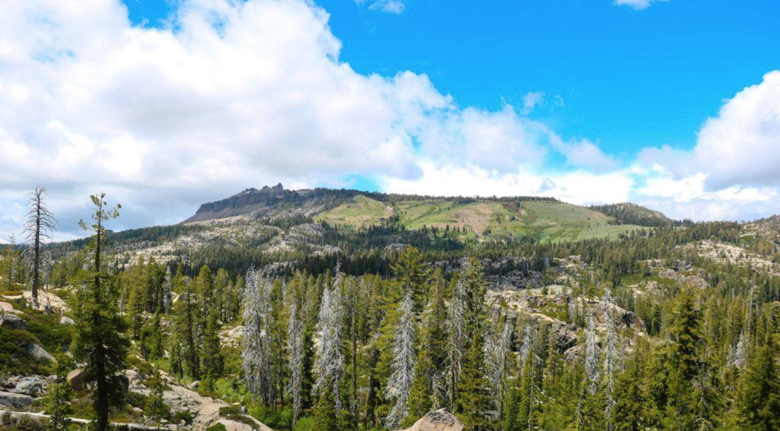
​Sky Mountain is 28 miles west of Truckee at an approximate elevation range of 5,500-6,000 feet. The parcel encompasses many scenic lakes in the high elevation mountains of the Sierra.  It is surrounded by National Forest System lands managed by the Tahoe National Forest and private property. The parcel is accessible via Lake Valley Road, which is accessed from the Yuba Gap exit off of Interstate 80.

It will serve as science camp for sixth graders in the Manteca and Ripon unified school districts as well as other students in the county and throughout the San Joaquin Valley starting in the 2011-2012 school year.
Situated at the top of the North Fork of the American River in the Sierra in Tahoe National Forest in Placer County, the property will become the new home for Science Camp for San Joaquin Valley students.
Sky Mountain includes cabins, a gymnasium, lodge, and other facilities surrounded by acres of forest alongside a pristine mountain lake. The 62.68-acre parcel was donated by the Pacific Gas & Electric to SJCOE.  Preexisting infrastructure, capital assets, and $2.5 million to support code compliance and infrastructure reinforcement were donated by the Pacific Forest and Watershed Lands Stewardship Council.  In 2016, the SJCOE applied to become a grantee of the property through the Stewardship Council, which oversees more than 140,000 acres of watershed lands owned by PG&E to ensure they are used to benefit the residents of California.

Sky Mountain is located 45 miles northeast of Auburn and 28 miles west of Truckee at an approximate elevation range of 5,500-6,000 feet. The parcel encompasses many scenic lakes in the high elevation mountains of the Sierra.  It is surrounded by National Forest System lands managed by the Tahoe National Forest and private property. The parcel is accessible via Lake Valley Road, which is accessed from the Yuba Gap exit off of Interstate 80.

As part of the transaction, the SJCOE will work closely with the Wildlife Heritage Foundation (WHF), a non-profit organization dedicated to protecting and enhancing wildlife habitat and connecting Californians to the outdoors. As the holder of the conservation easement, the WHF will oversee the protection of the ecological habitat and ensure the appropriate use of this natural open space.

Sky Mountain will be the new location of Science Camp, as the SJCOE outdoor education program has been known to students for over 60 years who have come to the Santa Cruz Mountains through a contract with the YMCA at Camp Jones Gulch. 

“We are grateful for the long-standing partnership we have had with the YMCA and Camp Jones Gulch. The memories and traditions created there are shared by generations of our county’s residents,” San Joaquin County Superintendent of Schools James Mousalimas said. “It is difficult to close this chapter in our history, but Sky Mountain allows us more opportunities to provide outdoor education experiences to students year-round We are excited to offer Science Camp at Sky Mountain beginning in the 2021-2022 school year as we develop the next generation of innovative, ecologically literate community stewards and leaders. The possibilities are endless.”

By owning Sky Mountain, the SJCOE will have the flexibility to offer year-round programs to students of all ages and provide other opportunities for educators and community partners.

Peter Ottesen, the former director of science camp for 35 years, believes the new site at Sky Mountain will allow the award-winning resident outdoor school to flourish in the years to come. 
"The opportunity to acquire Sky Mountain, complete with modern living spaces and food service facilities and a travel time not encumbered by dense traffic, provides assurances that the popular program will continue well into the future,” said Ottesen.  “The change of sites couldn't happen at a better time."

Since 1976, the Sky Mountain property has been leased from PG&E for a camp and conference center.  During the planning phase of this new project, the SJCOE is working on renovating the preexisting facilities and designing a new curriculum specific to the unique ecosystem that aligns with the Next Generation Science Standards and makes connections with California’s Environmental Principles and Concepts. 

“Students will learn about different ecosystems and how watersheds are connected.  Snow is connected to rivers, rivers are connected to the Delta in San Joaquin County, and the Delta is connected to the ocean,” SJCOE STEM Director Annie Cunial said.  “And year-round activities will range from canoeing and archery in the summer to snowshoeing in the winter,” she said.  “These activities will enhance students’ experiences as they learn about the history of the land from the Native American tribes to early California explorers, as well as flora, hydroelectric dams, conifer forests, wildlife, industries, careers, and more.”

Due to the COVID-19 pandemic, which has changed how field trips can be offered, programming information for the new center will not be available until the 2021-2022 school year.  The SJCOE will provide an update once programming begins. 

CLICK HERE to see the original article in the Manteca Bulletin Newspaper.

Self guided hikes with the Wild and Scenic Film Festival

1/19/2021

 
Picture
During the festival, normally held at Grass Valley and Nevada City, there are many events other than just films. This year, in addition to a virtual festival, there are local hikes with "help." These self-guided excursions are to help you keep the “Wild” in Wild & Scenic. While these hikes are for Nevada County, CA we encourage you to go get outside and explore wherever you may be!

1. Scenic Highway 49 from Nevada City to Sierra City
  • Heading toward Sierra City on Highway 49, you will cross the stunning, emerald south fork of the Yuba, a state-designated Wild & Scenic river canyon.
  • Continuing on to cross the middle fork at Oregon Creek Day-Use Area.
  • As you slowly climb in elevation, Highway 49 catches up to the north fork of the Yuba River, where you’ll find plenty of small parks and pull-offs along the way with breathtaking views of the river canyon where you can be sure to stay socially distant.

2. Hiking for Good presents Connect with Nature on the Hirschman Trail 
  • Just a short one-mile walk from downtown Nevada City, Hirschman Trail is an easy to moderate forested adventure found in the Deer Creek Watershed.
  • Now teeming with wildlife, the trail’s showpiece is Hirschman Pond, created by hydraulic mining during the Gold Rush.
CLICK HERE for the PDF file guide


3. Explore Tahoe National Forest
  • If you head up Highway 20, just past Harmony Ridge you’ll enter the Tahoe National Forest.
  • The Pioneer Trail runs parallel along Highway 20 through a beautiful canopy of trees. Look for pull outs on the left side of the highway all the way to Conservation Camp Road. There’s plenty of flat space to stretch your legs and find solitude in the forest. Continue upward to find parks with 180-degree scenic views of the Sierra Nevadas.

4. It’s All Newt to Me: A Self-Guided Orientation to Amphibians of the Yuba
  • While most people spend their hikes facing forward, look down for a change and discover the world of amphibians.
  • Explore the Yuba Watershed from the eyes of frogs and salamanders on easy trails near Nevada City.
  • This self-guided excursion is supplemented by materials from avid herper Shannon Hedge to teach you about the wonders of these animals at your feet.
Click Here for the PDF guide

​5. Importance of Nisenan Voice in Our Community
The Deer Creek Tribute Trail is a great opportunity for community education and outreach. The Nisenan Cultural Reclamation Corridor along Deer Creek will connect two points of the Tribute Trail. Wolf Creek in Grass Valley also offers educational opportunities through interpretive signage. Nevada City Rancheria Tribal Spokesperson Shelly Covert will discuss the visibility the trails have brought to the Tribe as well as the critical importance of connecting people with nature.

CLICK HERE to see the Wild and Scenic Film Festival Excursions webpage.

Exploring Hidden Falls with Mary West

1/8/2021

 
Picture
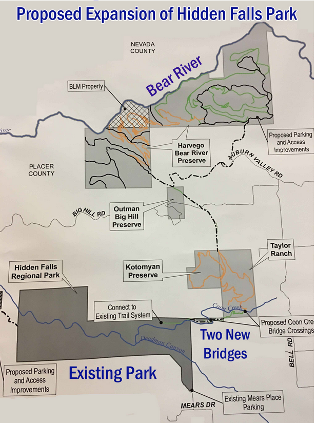
Now is the time to check out the trails that are either too crowded or too hot later in spring and summer. Hidden Falls Regional Park in Placer County is not a spur of the moment trip. Hidden Falls requires a reservation you can get online.

The green meadows and flowing creeks make this regional park a gem in Placer County in winter. The trails are well maintained, the bridges and decks are handsome and sturdy. The variety of trails will keep you going back again and again.

You may have heard parking is difficult. Yes, if you go after 10 a.m. the parking lot fills up quickly. I suggest going early or late. On my last trek, I went in the afternoon and I was able to park in the middle of the main lot and the light for photography was amazing.

I would encourage you to choose a hike while the weather is still mild. I have hiked the area several times and in the heat of summer. The grasses are dry and much of the trail is exposed to direct sun, making for a hot day. The payoff is finding a nice swimming hole along Coon creek.

This is a heavily trafficked area. The easy to moderate trails make it great for families and those who are looking for a shorter outing. If you get beyond the inner trails that lead to the falls, such as River Otter Loop, you leave the crowds and have more of the trail to yourself.

These are multi-use trails so expect to share the path with mountain bikes and horses. And don’t be surprised if you see grazing cattle or sheep too.

To get to Hidden Falls from Interstate 80, head north on Highway 49 toward Grass Valley. Turn left on Palm Ave to Mount Vernon to 7587 Mears Place, Auburn. If you are coming from Grass Valley you could take Joeger or Atwood Roads to Mount Vernon to Mears Place.

With 1,200-acres to wander, follow a route that looks like fun and enjoy.

Mary West is author of the book series Day Hiker – Gold Country Trail Guide I, II and III (Available on Amazon). The books are a collection of the Day Hiker columns where West shares her longtime love of the outdoors, favorite hikes in Northern California’s Gold Country and beyond. West was the recipient of the 2017 and 2019 CRAFT Award for Best Outdoor Column and the 2020 Craft Award for her second book in the series-Day Hiker Gold Country Trail Guide by the Outdoor Writers of California. You can follow West on Facebook and Instagram.

CLICK HERE to see complete article and more photos in The Union newspaper.
​


<<Previous

    Trail News

    Visit this page for all of the latest Trail News that affects our area.

    Archives

    February 2021
    January 2021
    December 2020
    November 2020
    October 2020
    September 2020
    August 2020
    July 2020
    June 2020
    May 2020
    April 2020
    March 2020
    February 2020
    January 2020
    December 2019
    November 2019
    October 2019
    September 2019
    August 2019
    July 2019
    June 2019
    May 2019
    April 2019
    March 2019
    February 2019
    January 2019
    December 2018
    November 2018
    October 2018
    September 2018
    August 2018
    July 2018
    June 2018
    May 2018
    April 2018
    March 2018
    February 2018
    January 2018
    December 2017
    November 2017
    October 2017
    September 2017
    August 2017
    July 2017
    June 2017
    May 2017
    April 2017
    March 2017
    February 2017
    January 2017
    December 2016
    November 2016
    October 2016
    September 2016
    August 2016
    July 2016
    June 2016
    May 2016
    April 2016
    March 2016
    February 2016
    January 2016
    December 2015
    November 2015
    October 2015
    September 2015
    August 2015

    Categories

    All

    RSS Feed

Home
Contact
 Mother Lode Trails is YOUR local non-profit trail information and resource website. Here you can find
up-to-the minute information on trail alerts, links and trail news for Placer, Nevada, El Dorado, Yuba and
Sacramento counties. Mother Lode Trails is trademarked.