MOTHER LODE TRAILS
  • Home
  • About
  • Contact
  • Volunteer
  • Links
    • Law Enforcement Emergency
    • Federal, State, County Districts Parks & Trails
    • Running Clubs
    • Equestrian Clubs
    • Mt. Bike Clubs
    • Hiking Clubs
    • Trail Advocacy Organizations
    • Phone Numbers State & Federal Parks, Trails & Lands
    • Where to Eat on the Trails
  • News
  • Alerts

Hike of the month: Tahoe Pyramid Trail, new section

11/21/2019

 
Picture
The Truckee-Donner Land Trust sends along information:
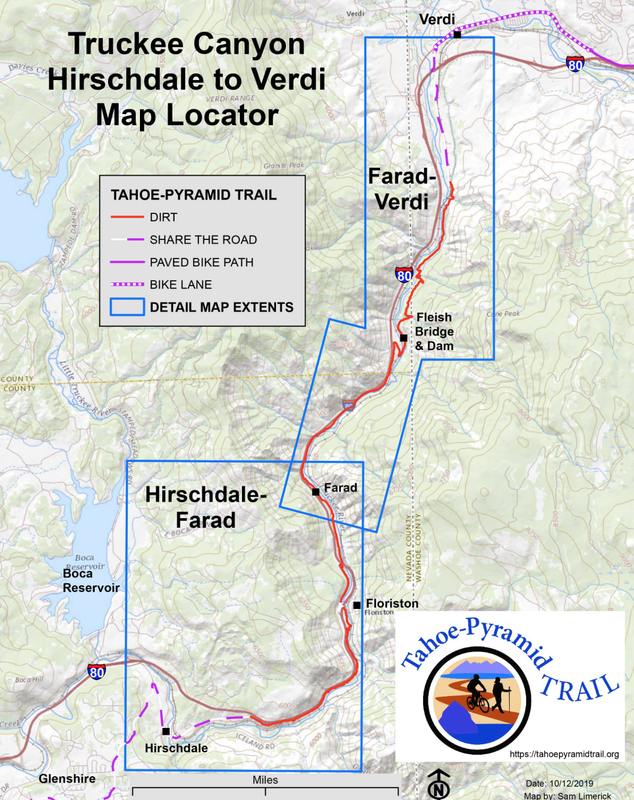
The newest section of the Tahoe Pyramid Trail starts in Hirschdale, just east of Glenshire, and ends in Floriston, roughly four miles downstream. Along the route th trail provides sweeping view of the canyon and approaches the banks of the Truckee River in several locations. Occasionally, mandated by rugged terrain, the trail nears the interstate above, but is generally quiet and scenic.
Mixed conifers give way to sage as the trail heads down, with willows, cottonwood and alders along the river. Of note, mountain mahogany trees are also along this stretch of trail.
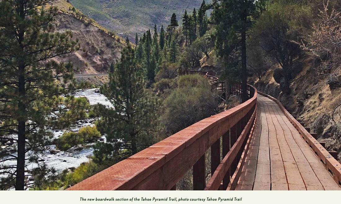
As the trail approaches Floriston, a new stair and boardwalk section of the path on the Hogback Ridge are well worth a visit, cantilevered out off a steep slope dropping down to the river below.
The surrounding Truckee River canyon walls include numerous Land Trust acquisitions totaling more than 5,000 acres, including Gray Creek, properties above Floriston and other conservation easements.
For those looking to explore farther, the trail crosses under the interstate in Floriston and continues down toward Farad and Verdi.
This trail is open to hikers, bikers, but closed to equestrians.

Article and photo from the Tahoe Donner Land Trust Newsletter here.
​
Click here for more detailed information and maps.
Picture

Day Hiker: Stagecoach Trail in Auburn State Recreation Area

11/20/2019

 
Picture
It’s time to start coming out of the mountains to some of our favorite foothill trails. Fall and winter are my favorite hiking seasons. I do love the flowers in spring but the solitude of winter hikes is charming to me.
The Stagecoach Trail in the Auburn State Recreation Area is three trails in one. Park in the confluence area near the kiosk. Keep in mind there is a $10 day-use fee. Behind the state park kiosk there is a trail that leads under the Foresthill Bridge (The tallest bridge in California at 730 feet). You will be headed up river left — not to be confused with the popular Clementine trail on the other side of the North Fork of the American.
Behind the kiosk you hike the moderate uphill climb toward the bridge with the river on your right. If you know the area you may be familiar with the two left turns off the main trail. These lead to first the lower and then upper Stagecoach Trail.
If you take the first sharp left onto Lower Stagecoach at the sign you enjoy the view of the Mountain Quarries Railroad Bridge and the American River that flows beneath. You can continue to the bench for a view of the confluence area and onto Russell Road. The out-and-back hike is approximately 2 miles.
Upper Stagecoach offers nice canyon views and isn’t as heavily trafficked at Lower Stagecoach. Keep your eye out for the heart tree. It is a tree that has been covered with heart shaped rocks placed in the nooks and crannies of the tree bark. Both trails are home to a variety of wildflowers in the spring.
Have you ever continued along the trail by the river and under the bridge? If not, I suggest you give it a try.
Park rangers have warned me not to linger under the bridge as objects have been dropped and could be a danger to hikers or mountain bikers traveling under the bridge. Walking under the 730-foot foundation offers a different view of the bridge those of us who hike here regularly know so well.
The trail drops down to the base of the foundation before continuing along the canyon wall. It isn’t a very long trail, maybe 2 miles round trip, but at the end of the trail there is a great picnic spot. An open area that overlooks the river and has a seasonal waterfall that runs along the edge of the grassy area.
A combination of trails can make for a good workout and great views of the river and canyon.
Mary West is the author of the book series “Day Hiker — Gold Country Trail Guide.” 

To see the original article and photos by Mary West in the Mountain Democrat newspaper, CLICK HERE.

North Yuba Forest Partnership signs MOU for unprecedented 275,000 acre forest restoration project

11/8/2019

 
Picture
MARYSVILLE, Calif. (November 6, 2019) – A diverse group of nine organizations announced today their commitment to prioritize, plan, and execute forest restoration on an unprecedented scale in the North Yuba River watershed, covering 275,000 acres of the northern Sierra Nevada.
The memorandum of understanding spells out the group’s commitment to work together to increase the pace and scale of ecologically-based restoration within the North Yuba River watershed and to prioritize community safety, forest health, and resilience through landscape-scale restoration.
The North Yuba Forest Partnership includes Blue Forest Conservation, Camptonville Community Partnership, National Forest Foundation, The Nature Conservancy, Nevada City Rancheria, Sierra County, South Yuba River Citizens League, The United States Forest Service – Tahoe National Forest, and Yuba Water Agency.
“Many forests in the North Yuba River watershed are critically unhealthy, overcrowded with small trees and brush,” said Eli Ilano, Tahoe National Forest Supervisor. “Unhealthy forests are at a greater risk of high-severity wildfire due to fire suppression and historic timber harvesting practices, a risk that is exacerbated by a changing climate.”
The North Yuba River watershed runs through multiple Northern California counties and two national forests, from Yuba Pass to New Bullards Bar Reservoir. The area includes thousands of acres of forest habitat, is an important source of water for downstream users, supports high biodiversity, is home to many rural communities, and offers excellent opportunities for recreation.
“We’re loving our forests to death,” said Willie Whittlesey, Assistant General Manager of Yuba Water Agency. “A ‘hands-off’ approach to forest management is no longer an option now that our communities, infrastructure and water supply are at significant risk. To make a meaningful impact in this massive effort, it’s going to take all of us who care about the watershed coming together.”
Forests once characterized by large, widely-spaced trees and beneficial low-to-moderate severity fires are now overrun with vegetation that is not fire-resilient. This has increased the risk of destructive wildfire causing significant damage to local communities, entire ecosystems, and watershed health.
Projects to restore resilience to the North Yuba River watershed include clearing underbrush, thinning smaller trees, managed burning, reforestation, and meadow restoration, among other efforts. In addition, traditional ecological knowledge from the local Nisenan people will be incorporated into planning and design.
“We are planning ecological forest management projects using the best available science,” said Rachel Hutchinson, River Science Director for South Yuba River Citizens League. “It’s important to all of us that we strike that balance between the desperate need to restore the forest’s resilience to wildfire and the need to preserve and protect vulnerable species and cultural artifacts.”
“This public-private partnership holds promise as a model to restore the forests of the Sierra at a landscape scale,” said David Edelson, Forest Program Director of The Nature Conservancy. “By using the latest science, innovative planning and new funding approaches, together we can accelerate the restoration of our forests while maintaining the environmental safeguards and community input that are central to success.”
This effort is expected to take up to 20 years to complete, with the highest priority given to at-risk communities, emergency response, evacuation access routes, forests of critical ecological importance, and areas that have the potential to stop a wildfire from spreading.
While planning efforts for the larger North Yuba River watershed are just beginning, the 14,500-acre Yuba Project is already underway, serving as a pilot for the larger-scale North Yuba River watershed restoration effort. The Yuba Project is benefitting from a new financing tool called the Forest Resilience Bond (FRB), a public-private partnership that accelerates the pace and scale of forest restoration through investment from private capital sources, including foundations, impact investors, and insurance companies.
“Investor demand for this first-of-its-kind private investment to support public land management greatly outpaced supply. Investors are eager to finance future, larger projects,” said Zach Knight, managing partner of Blue Forest Conservation, the lead developer of the FRB. “The North Yuba Forest Partnership plans to use the FRB model and other innovative approaches to finance planned work in the North Yuba River watershed.”
To learn more, visit the partnership website at yubaforests.org.
 
About the Partners:
  • Blue Forest Conservation: An innovative nonprofit organization committed to creating sustainable financial solutions to pressing environmental challenges.
  • Camptonville Community Partnership: A nonprofit organization with a mission of rural people working together for a safe, sustainable, and healthy community.
  • National Forest Foundation: Engaging Americans in promoting the health and enjoyment of our public forests.
  • The Nature Conservancy: One of the world’s leading conservation organizations, dedicated to scaling up forest restoration across the Sierra Nevada.
  • Nevada City Rancheria: The local tribal unit of the Nisenan people of Northern California, passionate about forest health and management, as it is central to their well-being.
  • Sierra County: Positioned at the headwaters of the North Yuba River, Sierra County’s highest priorities include reducing wildfire risk, enhancing forest and watershed health through implementation of fire resilient treatments, and protecting its rural communities.
  • South Yuba River Citizens League: Uniting the community to protect and restore the Yuba River watershed, SYRCL understands that forest health and resilience are essential to a healthy watershed.
  • The United States Forest Service – Tahoe National Forest: Sustaining the health, diversity, and productivity of the nation’s forests and managing over 50 percent of the Yuba River watershed, which lies within the Tahoe National Forest.
  • Yuba Water Agency: A special district in Yuba County, committed to forest health in the entire Yuba watershed, to ensure a sustainable water supply and reduce the risk of fire for the people of Yuba County.
Contact:
DeDe Cordell, Yuba Water Agency
Communications Manager
dcordell@yubawater.org
(530) 329-9563

Go here for original press release from the South Yuba River Citizenship League

https://yubariver.org/2019/11/north-yuba-forest-partnership/

    Trail News

    Visit this page for all of the latest Trail News that affects our area.

    Archives

    February 2023
    January 2023
    November 2022
    October 2022
    September 2022
    August 2022
    July 2022
    June 2022
    April 2022
    March 2022
    January 2022
    November 2021
    October 2021
    August 2021
    July 2021
    June 2021
    May 2021
    April 2021
    March 2021
    February 2021
    January 2021
    December 2020
    November 2020
    October 2020
    September 2020
    August 2020
    July 2020
    June 2020
    May 2020
    April 2020
    March 2020
    February 2020
    January 2020
    December 2019
    November 2019
    October 2019
    September 2019
    August 2019
    July 2019
    June 2019
    May 2019
    April 2019
    March 2019
    February 2019
    January 2019
    December 2018
    November 2018
    October 2018
    September 2018
    August 2018
    July 2018
    June 2018
    May 2018
    April 2018
    March 2018
    February 2018
    January 2018
    December 2017
    November 2017
    October 2017
    September 2017
    August 2017
    July 2017
    June 2017
    May 2017
    April 2017
    March 2017
    February 2017
    January 2017
    December 2016
    November 2016
    October 2016
    September 2016
    August 2016
    July 2016
    June 2016
    May 2016
    April 2016
    March 2016
    February 2016
    January 2016
    December 2015
    November 2015
    October 2015
    September 2015
    August 2015

    Categories

    All

    RSS Feed

Home
Contact
 Mother Lode Trails is YOUR local volunteer-run trail information and resource website. Here you can find
up-to-the minute information on trail alerts, links and trail news for Placer,  Yuba, and Nevada counties.
Mother Lode Trails is trademarked.