MOTHER LODE TRAILS
  • Home
  • About
  • Contact
  • Volunteer
  • Links
    • Law Enforcement Emergency
    • Federal, State, County Districts Parks & Trails
    • Running Clubs
    • Equestrian Clubs
    • Mt. Bike Clubs
    • Hiking Clubs
    • Trail Advocacy Organizations
    • Phone Numbers State & Federal Parks, Trails & Lands
    • Where to Eat on the Trails
  • News
  • Alerts

Still a few days to comment on Placer Country Parks and Trails Master Plan

1/29/2022

 
Picture
Jan 28, 2022 2:00 PM 
Placer County shared elements of the Parks and Trails Master Plan final draft during a virtual town hall Thursday. Feedback is still being accepted for a few days here: https://placerparksplan.com/

Placer County hosted a virtual town hall Thursday to provide county residents with an update of the final draft of the Parks and Trails Master Plan.

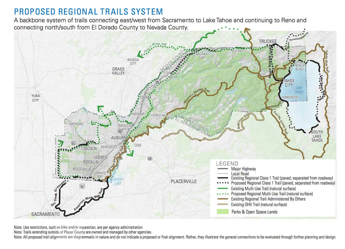
According to a county news release, the plan is a culmination of a five-year process to reflect the recreational needs of Placer communities, including sports in Granite Bay and Loomis, a connected trail system and indoor recreation for eastern Placer during the winter.

Placer County Parks Administrator Andy Fisher noted each project within the plan will undergo a detailed environmental review and public process, and the plan will assist with prioritizing where the county implements its time and resources.

According to Stephanie Grigsby, project manager with Design Workshop, revisions to the plan since the 2021 draft include technical edits and trail connectivity like adding a trail connection along Alpine Meadows Road, reflecting desired park amenities and adding a new category to recognize partner agency projects.

“This idea of really looking at the opportunity that the county has to, again, connect people to nature in a way that’s particular to the resources that the county has,” Grigsby said.

According to Fisher, projects within the plan include the Hidden Falls Regional Park trail expansion, a Newcastle ballfield, Sheridan Park, the Dry Creek Greenway Trail, the Resort Triangle Shared Use Path, Horseshoe Bar Trail and a trail from Auburn to Kingvale. The plan also includes partner agency projects like the Auburn Area Recreation and Parks District’s 24-acre Regional Park expansion and the Colfax skate park.

Categorized projects which may be partially or fully funded and in a planning or design stage (Tier 1) and projects which are feasible but do not have all of the funding (Tier 2). Fisher said partner agency projects are listed separately, but the county will still have assistance or interaction with them.

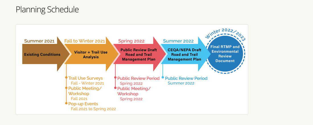
Fisher noted although the recent draft is labeled as final, feedback is still being accepted for the plan. The plan is scheduled to go to the Parks Commission on Thursday, Feb. 10. The plan and the commission’s recommendation is then tentatively scheduled to be reviewed by the Board of Supervisors in March.

Placer residents can review the final draft of the Parks and Trails Master Plan and provide feedback at placerparksplan.com.

CLICK HERE to see the original article in the Gold Country Media.


Gold Country Trails Council Jan.-Feb. newsletter and 2022 calendar for trail work. Join them!

1/28/2022

 
Picture

​Since 1981, Gold Country Trails Council (GCTC) has created, planned, built and maintained over 100 of miles of non-motorized trails and three horse camps in the Tahoe National Forest. Today, the group has grown to over 500 equestrians who mainly live and recreate in Placer and Nevada counties. Its growth has made it the largest local equestrian trails group in California. 

The volunteers of GCTC hold the blue ribbon for putting in more trail work hours in Tahoe National Forest than any other group.

Every other month, GCTC published a newsletter outlining their trail work and plans for the future. This current issue also has the 2022 calendar.

To access the current newsletter CLICK HERE.

To access previous newsletters, CLICK HERE.
Picture

30-day comment period starts for Pines to Mines trail - motorized vs. non-motorized controversy

1/27/2022

 
Picture
Tahoe National Forest (TNF) made the Pines to Mines Trail public documents available to the public today. CLICK HERE TO FIND THE PUBLIC DOCUMENTS. 

The public has 30 DAYS in which to comment. From TFN: "To assure your comments are fully considered during the scoping phase of this proposal please submit them within 30 days."

TO COMMENT or OBJECT TO PROJECT:
<https://cara.ecosystem-management.org/Public//CommentInput?Project=61221>


CONTROVERSY OVER MOTORIZED USE
Trail users' representatives have been working on this trail for years as a designated non-motorized trail. Public support and money raised for the Pines to Mine Trail project specified it was to be a "non-motorized" trail. The controversy started at the August 2021 Nevada County Board of Supervisors meeting to approve funding. Tahoe National Forest Supervisor Eli Llano included into request for funding the environmental report the use of motorized e-bikes. The trail-using public and then the Nevada County Board of Supervisors objected and said they were not appraised of this change and would not provide the funding promised for the environmental report if e-bikes were allowed. Here is the article:
"Nevada Co Board of Supes approves funding for non-motorized Pines to Mines Trail without the addition of motorized e-bikes"

LETTER OF SUPPORT FROM NEVADA CO BOARD OF SUPERVISORS
"The Nevada County Board of Supervisors would like to express their support for the proposed Pines To Mines Trail, a multi use, non-motorized trail connection between the Nevada County municipalities of Truckee and Nevada City. The trail will be suitable for use by hikers, equestrians, and mountain bikers."
Complete letter CLICK HERE.

REGARDLESS OF OBJECTIONS, E-BIKES MENTIONED AS AN ALLOWABLE USE IN PUBLIC DOCUMENTS
The e-bike inclusion is now in the public documents posted online. It is up to the public to object over the inclusion of allowable use of motorized e-bikes on the Pines to Mines non-motorized trail.

Here are the specific paragraphs in the Pines to Mines Trail public documents mentioning
e-bikes:


1. IN THE PINES TO MINE DRAFT OF PROPOSED ACTION
"Designation of allowable use – Designate the allowable uses of the proposed Pines to Mines Recreational Trails system. Forest Plan direction and Agency regulations, including the 2005 Travel Management Rule if applicable, along with different use scenarios and public input, will be assessed to determine the allowable uses. Potential uses include hiking/walking, running, mountain biking (including pedal-assist Class 1 EBike), and equestrian riding."
The trail map was cut off to not show the legend that specifies "non-motorized" trail, but the other links on the website include the trail map and do show the legend.

2. IN THE LEGAL NOTICE:
Designating the allowable uses of the proposed Pines to Mines Recreational Trails system. Forest Plan direction and Agency regulations, along with different use scenarios and public input, will be assessed to determine the allowable uses. Potential uses include hiking/walking, running, mountain biking (including pedal-assist Class 1 E-Bike), and equestrian riding.

3. IN THE PINES TO MINES SCOPING NOTICE
The project’s proposed actions include: Constructing approximately 16-18 miles of new, native surface, single-track trail from Eagle Lakes to Donner Summit connecting the existing Grouse Ridge and Hole in the Ground trails; Designating all, or portions of, approximately 50 miles of identified existing Forest Service System trails as part of the new Pines to Mines Recreational Trail system including Donner Lake Rim (15E75), Grouse Ridge (13E28), Hole in the Ground (14E25), Pioneer (09E11), and Spaulding Lake (12E40); and Designating the allowable uses of the proposed Pines to Mines Recreational Trails system. Forest Plan direction and Agency regulations, along with different use scenarios and public input, will be assessed to determine the allowable uses. Potential uses include hiking/walking, running, mountain biking (including pedal-assist Class 1 E-Bike), and equestrian riding.

4. ON THE MAPS
On each legend, trails are designated "non-motorized", but the new trail is not designated as such.

Copy of the email the public received today:

---------------- Begin Forwarded Message ----------------
Subject: Notice of Public Scoping
Date Sent: Thursday, January 27, 2022 4:00 PM
From: Brokaw, John - FS <john.brokaw@usda.gov>

Dear Interested Party:
The Tahoe National Forest is initiating scoping for the proposed Pines to Mines Trail Project for the development of a multi-use native surface trail system connecting Nevada City, CA to Truckee, CA.

The proposed trail system would be approximately 68 miles in length and would include all, or parts, of existing Forest Service network trails, as well as some new trail construction.

The proposal will serve to promote safe and sustainable recreation opportunities on public lands while continuing to meet our responsibilities to protect and preserve public resources.

We encourage you to review the attached information and follow the instructions provided to submit comments about the project. To assure your comments are fully considered during the scoping phase of this proposal please submit them within 30 days. Detailed information about the proposed action is posted on the Tahoe National Forest website at:

https://www.fs.usda.gov/project/?project=61221

Thank you for your participation.

John I Brokaw
Environmental Coordinator
Forest Service
Tahoe National Forest, Yuba Ranger District
p: 530-265-4531
f: 530-478-6109
john.brokaw@usda.gov
<mailto:john.brokaw@usda.gov>

631 Coyote Street
Nevada City, CA 95959-2250
www.fs.fed.us
​<https://www.fs.fed.us>
<https://usda.gov/>
[Forest Service Twitter]<https://twitter.com/forestservice>
[USDA Facebook]<https://www.facebook.com/pages/US-Forest-Service/1431984283714112>
Caring for the land and serving people

====


You can find the PINES TO MINES public documents here:
<https://www.fs.usda.gov/project/?project=61221>


The public has 30 DAYS in which to comment. From TFN:
"To assure your comments are fully considered during the scoping phase of this proposal please submit them within 30 days."

TO COMMENT or OBJECT TO PROJECT:
<https://cara.ecosystem-management.org/Public//CommentInput?Project=61221>


Can bikers, hikers, horses share the Browns Ravine trail?

1/26/2022

 
Picture
Folsom Lake SRA wants public input on plans to change trail use designation. Those wishing to share their thoughts, concerns or ideas on the project are urged to email them to trails@parks.ca.gov by Jan. 31 for review. Officials ask to make the subject line “Browns Ravine,” on the submissions.

"For many years, there has been sparring between hikers, horse enthusiasts and cyclists when it comes to sharing the real estate on various area trails.

Such discussions are arising again as officials from Folsom Lake State Recreation Area are proposing a change in designation of an area trail that is presently forbidden to mountain bikers. As officials look to move forward on the project, they are hoping to hear from area users and residents who have concerns or ideas regarding the change.

The Browns Ravine Trail is an unpaved, 11-mile trail connecting Browns Ravine to the Old Salmon Falls Trailhead. The current use designations on the Browns Ravine Trail are limited to hiking and equestrian.

The Browns Ravine Trail Change-in-Use (CIU) project proposes to change the trail’s use designation to multi-use. In addition to hiking and equestrian uses, the multi-use trail designation would allow bicycles on this trail. According to documents published by Folsom Lake State Recreation area, this proposed change is labeled as a “stand-alone project,” separate from the concurrent road and trails management plan.

While talks have increased on the project in recent months and a virtual public meeting was held on Jan. 12, the proposed designation of the popular trail is not a brand new topic. Efforts to change the designation first began in 2000 when the Folsom Lake Trails Advocacy Group (FTAG) was formed with the hopes of “increasing safe trail access and reducing conflicts among trail user groups.”

Folsom Lake Trails Advocacy Group members included a mix of equestrian, mountain biking, trail running and youth representatives and a team of state parks staff have facilitated dialogue among its members. The group met regularly over the course of two years, discussing many ideas for achieving its goals.

Folsom Lake Trails Advocacy Group eventually proposed a one-year pilot program that aimed to determine whether a trail within Folsom Lake SRA could be successfully converted from hiking and equestrian to multi-use. The Browns Ravine Trail was selected due to its relatively gentle terrain and light use and that the trail could be readily modified for the proposed change-in-use.

After more than two decades of evaluations and discussion, the project looks to be rolling forward but officials are seeking additional input from the general public. Over 120 readers shared their thoughts with the Folsom Telegraph through social media on Tuesday.

“Absolutely bikes should be allowed. People need to learn to coexist and work together,” said Karen Munoz of Cameron Park. “Walkers/hikers should yield to cyclists and cyclists should yield to horses. One group shouldn’t have more right to a trail system than another.”

Vanessa Boston utilizes area trails as an equestrian enthusiast. She expressed concerns for safety with a change to multi-use as she has seen close calls in the past on other such trails where the company is mixed.

“I'm a horse owner, so I'm biased. The speed at which bikes come down with relatively no sound and then these folks have their music in their ears. So many horses have been hit or nearly hit,” said Boston. “They are back on their way without so much as an excuse me. Keep them off the trails. Folsom has more bike trails than almost any other city.”

Jen Glowniak of Folsom is another horseback rider who cites past experiences make the mixing of the two a “terrible recipe.”

“No bikes. There's so much space for cyclists already,” she said. “I've been on a horse along Lake Natoma when a cyclist came ripping right past our five horses, didn't slow down, move over, nothing. Spooked one and the other four followed suit. Terrible recipe.”

Area resident Sunny Jewell frequently walks on the trail where the change is proposed and is opposed to the idea of mixed company.

“I don't want to see bikes on those trails. We have enough bike trails for them everywhere else,” said Jewell. “ I would like to walk in peace than having to worry about bikers yelling on your left or on your right.”

During the recent virtual meeting, officials discussed the safety concerns when it comes to horses and bikes sharing area trails, many of which already are multi-use. According to the presentation, over the last 10 years, 73 percent of 48 documented horse accidents have been solo incidents while 9 percent of those were reportedly caused by horses spooked by cyclists. According to the study, 73% of the documented 260 bicycle accidents were noted as solo accidents over the 10 year period.

As detailed in the most recent virtual meeting, the Change in Use (CIU) team recommends approving the proposed change to the local trail. However, they do so with a number of recommended modifications in design and management of the trail.

Folsom resident Phillip Barkow said everyone can share the trail as he has personally seen them do in other areas of the community. “Yes, we ride around horses on most other trails and are very polite; we normally stop until horses pass,” said Barkow. I’ve ridden on these trails for over 20 years with other riders and I’ve never seen a problem between bikes and horses; there’s always one idiot out there no matter what you’re doing or sport you’re in.”

The proposed modifications are focused on such concerns and ensuring that the trail will be “safe and sustainable” for all forms of permitted use.

The proposed Change in Use would enhance trail access and circulation for bikes. During the Jan. 12 meeting, it was noted that the current section of the trail that does not allow cycling use, is utilized much less to date by hikers or horseback riders.

The Change in Use evaluation noted that portions of the Browns Ravine Trails, which generally features sustainable grades and good lines of sight, are used  (illegally) regularly by mountain bikers.
According to the project summary detailed by Folsom State Recreation, the required enhancements include “trail reroutes, the reconstruction and widening of trail segments, bridges, the repair and or installation of drainage features and additional trail modifications. These proposed modifications, which prioritize trail safety and sustainability, have been identified and mapped.”

High-priority modifications, such as reroutes, aim to repair unsustainable trail segments that drain directly into streams and drainages. These modifications would need to be implemented prior to opening the Browns Ravine Trail to bikes.

As officials look to move forward, they are currently asking for public input to be considered.

Those wishing to share their thoughts, concerns or ideas on the project are urged to email them to trails@parks.ca.gov by Jan. 31 for review. Officials ask to make the subject line “Browns Ravine,” on the submissions.

--Article by Bill Sullivan

CLICK HERE to see the original article and photos in Gold Country Media.


Mt. bikers want Browns Ravine Trail, existing walking users object citing safety issues.

1/26/2022

 
Picture
"Browns Ravine Trail under evaluation to add mt. bikes." - Village Life news
Comments regarding the change-in-use (CIU) to add mt. bikes must be submitted by Jan. 31, 2022. Those wishing to share their thoughts, concerns or ideas on the project are urged to email them to trails@parks.ca.gov for review. Officials ask to make the subject line “Browns Ravine,” on the submissions. If passed, implementation of CIU modifications could start later this year.
​
"Trail users are once again butting heads regarding the allowance of bicyclists on Browns Ravine Trail, an unpaved, 11-mile track connecting Browns Ravine to the Old Salmon Falls trailhead.

Although changes-in-use (CIU) have been requested on nearly all trails within the Folsom Lake State Recreation Area where bike use is currently not allowed, the Browns Ravine Trail CIU is being evaluated as a separate project due to its relatively gentle terrain, good sight lines and connection to other multi-use trails. Efforts to allow bikes on the trail date back to 2000.

El Dorado Hills resident Mike Finta has fought bike use on this stretch for almost as long as he has lived on his property, 1,200 feet of which butts up against the Browns Ravine Trail.

“I have witnessed speeding, illegal mountain bikers spook horses by zooming up behind them, in one case causing a horse to almost throw its rider onto a barbed wire fence,” Finta told Village Life. “I have watched startled hikers stumble into the weeds or fall down the drop-off next to the trail and the mountain bikers rode by laughing at them.”
The 25-year resident went on to describe another biker who rode through his dog’s lead, ripping the lead from his dog’s neck.

“I have no problem with mountain bikers being on the trail,” Finta insisted, mentioning e-bikes as an added contributor to high velocity encounters. “The basic issue is the safety.

“However, in all these years, I have never seen or even heard of a park ranger being deployed with a radar gun, stopping speeding bikers on the Browns Ravine Trail and issuing citations, even though it has been off limits to bikes … the entire time,” 

“A speed limit on the trail is incredibly difficult for us to try to enforce,” said Folsom Sector Superintendent Richard Preston-LeMay at a virtual public meeting held earlier this month. “I think the modifications will help with some of the sight lines and assist with the safety out there. I do not anticipate posting speed limit signs all over the trail.”

Modifications included in the change in use (CIU) request outline trail reroutes, reconstruction of trail segments and bridges as well as repair and installation of drainage features.

Preston-LeMay also displayed accident history for the Folsom Lake Trail system over the past 10 years. Five accidents occurred on Browns Ravine Trail: three solo bike accidents, one horse versus pedestrian accident and one solo horse accident.

From Mother Lode Trails: Park Watch Report provided 100 trail incident reports for Folsom Lake SRA trails that have not been taken into consideration by State Parks. CA State Parks has no public reporting function to collect conflict and accident data to apply to possible CIU trail designations. 
Browns Ravine Trail has been used illegally by mt. bikers for years without citations. Many bikers exceed the park speed limit knowing the Park Superintendent Preston-LeMay has ordered no speed limit signs. 

Finta further cited the state park trails handbook specifies a multi-use trail must be 48 inches wide; on Browns Ravine Trail there are areas where the trail spans a mere 18 inches. “There are 100-foot sections here and there that physically cannot be modified,” he said, referring to steep terrain.

State Park Associate Landscape Architect Jason Spann maintained that the trails handbook actually specifies a minimum width of 36 inches and assured that the inconsistency was due to an outdated appendices section. “We are looking at widening some locations to help better meet that standard,” he said, stating that the ability of users to safely yield to others is the ultimate goal. “A lot of times you may have very short distances where you can’t get 36 inches that doesn’t really create any sort of hazard.”

Although local mountain biker Jeff Barker concedes that there are bikers who ride too fast, he said they make up the minority. “That’s such a small percentage of the actual users,” he shared. “That’s not any reason to keep an entire user group from enjoying something that is perfectly fine to share. It’s a public trail and public land.” He also notes what he sees as a lack of equity in bike-legal trail miles, 45 out of the 94 miles of trails within the Folsom Lake SRA.

Regarding the narrow points on the trail, Barker asserted that a flat shoulder permits safe passing. “On this particular trail, because of all the turns and some of the rough nature of it, there’s a lot of slowing elements like rocks or pinch points; you’re just not going that fast,” he said.

The trail is bookended by multi-use sections, requiring bikers who seek to legally link them in a single ride to navigate streets where there is often no shoulder. Barker said he’s excited the CIU will not only provide this connection, but also a better trail experience. He looks forward to attending future events to promote trail etiquette. “The high school and middle schools that are involved with the mountain bike programs, they get a ton of education. They’re the best behaved cyclists in the world,” he said.

“It’s been a popular bike trail. It’s been safe,” Barker added. “They’re just investing in this fear as reason to justify keeping something that actually works from moving forward. Haters are gonna hate.”
​
Finta isn’t alone in his aversion to trail bikers. “I’m heartbroken that they’re considering it again,” shared equestrian Cathy Andrews, who has lived next to the trail for 20 years and rides it almost daily. “People have reported that there are no accidents but it’s just not true. You get tired of reporting it to the park service when they do nothing.”

Andrews has proposed a dual trail like the one developed at Jenkinson Lake.

On the other hand, marathon runner Krista Campbell has been using the trail for 35 years and welcomes the bikers. “I feel like it’s a really safe trail,” said Campbell, who finds poison oak and snakes more dangerous than the bikers. “I’m all for the bikes because there’s bikes already. It’s a space we all share.” Nevertheless, Campbell expressed concern over what trail improvements may bring, including the possibility of increased traffic, litter and speed. “Without those obstacles that once were there, the bikes are going to go faster,” she cautioned.

Comments regarding the CIU must be submitted to trails@parks.ca.gov by Jan. 31. If passed, implementation of CIU modifications could start later this year and continue through 2024.

  -Article by Sel Richard

Click here to see the complete article and photos at Village Life.

Enjoy our trails more in 2022, join the Sierra Foothills Audubon group

1/25/2022

 
Picture
The Sierra Foothills Audubon Society is headquartered in Grass Valley, California. The membership area includes Nevada, Placer, Yuba, Sierra and El Dorado County.

Join Audubon to preserve and enjoy our natural world.
By joining Sierra Foothills Audubon Society, you will be taking an important and meaningful step in helping to protect our wildlife, natural places and contributing to our vital educational outreach program in local schools. SFAS chapter membership is $20.00 annually.

Become a member - two levels of membership are available:
1) SFAS Chapter Membership is $20 annually and includes a subscription to the Phoebe newsletter and an invitation to the many chapter activities. Send a check payable to Sierra Foothills Audubon Society, P.O. Box 1937, Grass Valley, CA 95945
2) An introductory membership to the National Audubon Society is $20 and includes SFAS Chapter Membership, subscriptions to the bi-monthly NAS Audubon Magazine and SFAS Phoebe newsletter. Send a check payable to NAS Membership Department, P.O. Box 422250, Palm Coast, FL 32142-2250. Please write C1ZC460Z in the memo section of your check; Sierra Foothills Audubon Society will be reimbursed $2 per NAS membership.
Email for more information:
Kate Brennan, Membership


2022 Field Trips to resume!
Field Trip Notice Its been a long dry spell but hopefully field trips will resume in January 2022. Outings will include protocols to provide safety for all participants. More details will be published in the January Phoebe, so watch for these and the scheduled trips. 

​
Webpage:
https://sierrafoothillsaudubon.org/


Most recent newsletter, the Phoebe:
https://sierrafoothillsaudubon.org/wp-content/uploads/2021/12/Phoebe-NovDec2021.pdf


Complete the Folsom Lake SRA trails plan survey and submit comments before January 31.

1/25/2022

 
Picture
You only have a few more days to register your comments and take the survey with State Parks regarding the Folsom Lake SRA Trails Plan. January 31, 2022 is the LAST DAY.

This plan will dictate how our trails are used for the next 20 years.
​Recently, there have been many changes in trails access and safety, with requests and rules adding mt. bikes to the few hiker/horse trails, and to add motorized e-bikes to non motorized trails. 
If you are a biker, you are probably happy with these changes. But, if you are a hiker, dog walker, senior, bird watcher, families with small children, a horse back rider, some of these new changes will dramatically impact the trails you use. If you are concerned about safe and more passive use of Folsom Lake SRA trails, it's time to make your voice heard.

COMMENTS? YES! STILL BEING RECEIVED!
If you missed the public meeting on October 26, 2021, review the presentation, summary, or archived recording, and share YOUR comments at trails@parks.ca.gov   
Comments received before Jan. 31, 2022, will be considered during the draft RTMP development phase. 


CLICK HERE TO TAKE THE SURVEY
https://www.parks.ca.gov/?page_id=28192

Below, photo of two members of the Folsom Lake SRA Mounted Patrol, one of the largest in the State.
Picture

New trail rules order for Folsom Lake SRA

1/19/2022

 
Picture
STATE OF CALIFORNIA DEPARTMENT OF PARKS AND RECREATION GOLD FIELDS DISTRICT
FOLSOM SECTOR

ORDER NO. 690 – 012 - 2022
January 1, 2022

THIS ORDER SUPERSEDES ORDER NO. 690-036-2022 Trail Use Policy
Amended regulation Section 4360 and 4360(a) of Title 14, California Code of Regulations, “Trail Use” Unless designated by the Department, all trails are open to pedestrians and closed to all other uses. All allowable trail uses will continue as they are designated at the date of adoption of these regulations unless and until a change is made by order of the District Superintendent. The Department may establish speed limits for designated trail use for units or portions thereof. If established, these speed limits will be posted.

4360(a) Trails in Reserves and Preserves as defined in Public Resource Code Sections 5019.65, 5019.71 and 5019.74 may be designated for bicycle or equestrian use when the District Superintendent has determined that such use is important for public access to the area or to make important connections to other trails and where it has been determined that impacts to the resources for which the area was established will not be significant as defined in Public Resources Code Section 21068 and Section 15382, California Code of Regulations Title 14.

Revisions to the California Vehicle Code (CVC) have removed e-bikes from the definitions of “motorized bicycle” and “motorized vehicle.” Section 312.5(a) of the CVC redefines e-bikes into three classes depending on the bicycle’s level of assistance and speed:

CVC § 21207.5(a) states, “a motorized bicycle or class 3 electric bicycle shall not be operated on a bicycle path or trail, bikeway, bicycle lane established pursuant to Section 21207, equestrian trail, or hiking or recreational trail, unless it is within or adjacent to a roadway or unless the local authority or the governing body of a public agency having jurisdiction over the path or trail permits, by ordinance, that operation”. CVC § 21113(g) stipulates that a public agency may adopt rules or regulations to restrict or specify the conditions for the use of e-bikes on public property under the jurisdiction on that agency. In Section 21207.5(b), a public agency having jurisdiction over a bicycle path or trail, equestrian trail, or hiking or recreational trail, may prohibit the operation of a class 1 or class 2 e-bikes on that path or trail. 

In accordance with the provisions of Section 4326 of Title14, California Code of Regulations and the above referenced California Vehicle Code sections, the following locations are the only routes designated open to bicycles, Class 1 and 2 e- bikes and/or equestrians on trails. All other trails or trail use shall adhere to the regulations established above in section 4360 and 4360(a) of Title 14, California Code of Regulations. 

To see the individual trails and their designations, CLICK HERE to see the complete order on the California State Parks website.

Continued:
All designated routes must be posted open by the use of a California State Parks approved and produced sign with a bicycle or equestrian symbol.
  1. No person shall operate a bicycle in such a way as to endanger hikers, equestrians or others using State Park Property, or in such a way as to damage park resources. No person shall operate a bicycle within Folsom Sector of the Gold Fields District at a greater speed than is reasonable and prudent, nor in any event in excess of 15 miles per hour. No person shall operate a bicycle in excess of 5 miles per hour when passing hikers or equestrians or when approaching and negotiating a blind turn. Blind turn is define as not being able to see oncoming traffic from a distance of 100 feet or less.
  2. Non-motorized,operator propelled devices including, but not limited to, skateboard, tricycles, unicycles, roller blades may only be used on trails open to bicycle use.
  3. The use of Class3 e-bike sare prohibited on all trails.
  4. Nothing herein shall affect any existing private, contractual, and residential or property rights.
  5. Exceptions to this order may only be granted in writing by the Gold Fields District Superintendent, 7806 Folsom Auburn Road, Folsom, CA 95630.
  6. Nothing herein shall be construed to be in derogation of other provisions of law.
Definitions
• Roads are paved and intended for motor vehicle traffic.
• Fire roads are unpaved and have limited or emergency motor vehicle use only.
• Trails are routes of six feet width or less and designed for foot traffic only, unless
otherwise open by this order.
So Ordered:
Signature of Barry C. Smith on file 1/1/2022
Barry C. Smith, District Superintendent Date
AUTHORITY: California Public Resources Code, Section 5003 and 5008, California Code of Regulation, Title 14, Sections 4301(i), 4326, 4360 


Regular hikes and runs and rides for the new year!

1/17/2022

 
Picture
If your New Year's resolution includes some regular exercise outside and enjoying nature and our trail network, then it's time to think about joining any of these groups that schedule regular outings. Hiking, riding, running, bird watching, dog walking, all GOOD for you and fun with others who like to do the same thing. Here is a partial list of those groups:


Weekly 5k fun run/walk (3.1 miles). Litton Trail, Sierra College, Grass Valley

https://www.meetup.com/hiking-nevada-county/events/283304964
Unguided 5k (3.1 miles, 2 loops) fun run. The Litton Trail (located across the street from Briar Patch co-op) allows leashed dogs. Suggested smartphone apps are Alltrails and Runkeeper (for tracking your time). Plenty of parking, lower lot, Sierra College. Enter Sierra College. First right into the lower lot. You will see the trailhead, on right, that runs directly down to the round-about. This is a great 5k run if you plan to run at least once per week or if you are working on your time.

Foothill Hikers - Auburn
https://www.meetup.com/Sierra-Foothill-Hikers/
Foothill Hikers welcomes new members of all ages, skill levels and interests that relish energy, camaraderie, and beautiful hikes merging one foot in front of the other. Our monthly calendar includes a variety of events mid-week and weekends covering the gamut of easy walks to more strenuous lengthy hikes all limited to a maximum of fifteen people.

Hammerin' Wheels Mountain Bike Club
https://www.meetup.com/HammerinWheelsMTBClub/
The Hammerin' Wheels are all about being active on your bicycle. We ride mostly on dirt trails but do ride paved trails/roads when necessary for trail connectivity. Due to the progression of our members over the years, most events are geared to Budding Intermediate to Advanced riders due to improved skill and fitness levels of our most active ride leaders and/or members who regularly join our rides, but occasionally have rides for novice or beginners. 

El Dorado Hiking
https://www.meetup.com/el-dorado-hiking/
This is a group for hiking all around El Dorado county. Both locals and non-locals welcome. Varied days/times, varied lengths and difficulties -- from casual walks to mountains. Varied locations too, but usually on the western slope. Hikes are usually posted a few days to a week before they happen. 

Trail Riders Connection - Auburn, Newcastle, Loomis, Sacramento
https://www.facebook.com/groups/716266175088148
Connecting with horse buddies in our local areas: Auburn, Newcastle, Penryn, Loomis, Granite Bay, Lincoln, Wilton, Cool, Grass Valley and Sacramento. A place to find friends for Day Rides during the week and on weekends. Members can post rides with the day and time to connect with other riders. If you are looking for a specific level of riding such as beginner or looking to ride with only 1 or 2 other people you can make that known too. Enjoy the Rides!

Placer County Group Hiking
https://www.meetup.com/Auburn-Hiking-Meetup/
Join us in exploring the wonders of the Auburn Recreation Area and lower Sierra Nevada Mt. range. Our hikes take us through incredibly beautiful regional parks, state parks, and open spaces. The group is open to adults who are physically fit, committed and show up (intermediate to strong hikers) who enjoy social hiking experiences, and meeting new people from all over Placer County.

Endurance Riding for Riders over 50
https://www.facebook.com/groups/312530175610289
This is a group for equestrian endurance competitors over 50.

Sierra Foothills Audubon Society
https://sierrafoothillsaudubon.org/

Sierra Foothills Audubon Society is headquartered in Grass Valley, California. Our membership area includes Nevada, Placer, Yuba, Sierra and El Dorado County and holds regular bird watching activities.

Auburn Area Trail Runners
https://www.facebook.com/groups/AuburnAreaTrailRunners
This is a place for anyone with a passion for running the beautiful trails in the American River Canyon and the greater Auburn, CA, area. AATR is the go-to trail running group for obstacle racers looking to branch out into trail running and racing. It also makes this a great place for any trail runners interested in trying an obstacle course race.

Gold Country Trails Council (GCTC)
http://www.goldcountrytrailscouncil.org/calendar--events.html
GCTC was founded as a non-motorized trail building and maintenance organization and provides goals and projects to sustain those founding beliefs. With over 500 active equestrian members, they hold regular day trail rides, horse camp outs and trail maintenance days in Placer and Nevada Counties.
-------------------------------------------------

This is just a beginning list for those of you who wish to turn a new leaf and join groups who will help you maintain your goals of fitness, tranquility and nature watching. Use Google, Facebook, MeetUp, Twitter and other social media to find new groups who have the same trail interests you do.


Western States Trail update - mud slide, downed trees, oh my!

1/16/2022

 
Picture
January 15 report from Jack Meyer, AERC Facebook page:
​Attention riders, Tevis 100 Mile Trail Ride course, between Foresthill and Auburn.
This mud/rock slide is about 2 miles down river from Rucky Chucky, going toward Poverty Bar. This slide covers about 15 feet of the trail. Then, just a little past this, there are two good size rocks in the trail, (about twice the size of a 5 gallon bucket). But easy for a horse to get over. Not long after you turn onto the single-track after leaving Rucky Chucky there is a small tree across the trail, about 10 inches in diameter, that you would have to break some limbs off of to get a horse over it. 
<<Previous

    Archives

    November 2023
    October 2023
    September 2023
    August 2023
    July 2023
    June 2023
    May 2023
    April 2023
    March 2023
    February 2023
    January 2023
    December 2022
    November 2022
    October 2022
    September 2022
    August 2022
    July 2022
    June 2022
    May 2022
    April 2022
    March 2022
    February 2022
    January 2022
    December 2021
    November 2021
    October 2021
    September 2021
    August 2021
    July 2021
    June 2021
    May 2021
    April 2021
    March 2021
    February 2021
    January 2021
    December 2020
    November 2020
    October 2020
    September 2020
    August 2020
    July 2020
    June 2020
    May 2020
    April 2020
    March 2020
    February 2020
    January 2020
    December 2019
    November 2019
    October 2019
    September 2019
    August 2019
    July 2019
    June 2019
    May 2019
    April 2019
    March 2019
    February 2019
    January 2019
    December 2018
    November 2018
    October 2018
    September 2018
    August 2018
    July 2018
    June 2018
    May 2018
    April 2018
    March 2018
    February 2018
    January 2018
    December 2017
    November 2017
    October 2017
    September 2017
    August 2017
    July 2017
    June 2017
    May 2017
    April 2017
    March 2017
    February 2017
    January 2017
    December 2016
    November 2016
    October 2016
    September 2016
    August 2016
    July 2016
    June 2016
    May 2016
    April 2016
    March 2016
    February 2016
    January 2016
    December 2015
    November 2015
    October 2015
    September 2015
    August 2015
    July 2015

    Categories

    All

    RSS Feed

Home
Contact
 Mother Lode Trails is YOUR local volunteer-run trail information and resource website. Here you can find
up-to-the minute information on trail alerts, links and trail news for Placer,  Yuba, and Nevada counties.
Mother Lode Trails is trademarked.