MOTHER LODE TRAILS
  • Home
  • About
  • Contact
  • Volunteer
  • Links
    • Law Enforcement Emergency
    • Federal, State, County Districts Parks & Trails
    • Running Clubs
    • Equestrian Clubs
    • Mt. Bike Clubs
    • Hiking Clubs
    • Trail Advocacy Organizations
    • Phone Numbers State & Federal Parks, Trails & Lands
    • Where to Eat on the Trails
  • News
  • Alerts

Big Western States 100 Run June 24-25!

6/23/2017

 
Picture
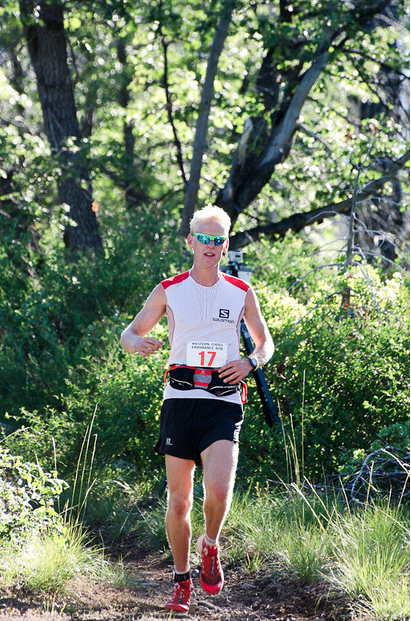
The big Western States 100 run is this weekend! The long distance runners will be starting in the snow at Squaw Valley,  using the Western States Trail through private, state and federal lands, ending in Auburn. If you are not participating in this event, please use other trails.

From the Western States 100 website:
The Western States 100-Mile Endurance Run is the world’s oldest 100-mile trail race. Starting in Squaw Valley, California near the site of the 1960 Winter Olympics and ending 100.2 miles later in Auburn, California, Western States, in the decades since its inception in 1974, has come to represent one of the ultimate endurance tests in the world.

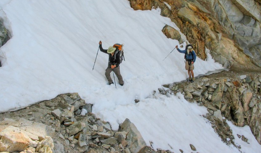
Following the historic Western States Trail, runners climb more than 18,000 feet and descend nearly 23,000 feet before they reach the finish line at Placer High School in Auburn. In the miles between Squaw Valley and Auburn, runners experience the majestic high country beauty of Emigrant Pass and the Granite Chief Wilderness, the crucible of the canyons of the California gold country, a memorable crossing of the ice-cold waters of the main stem of the Middle Fork of the American River, and, during the latter stages, the historic reddish-brown-colored trails that led gold-seeking prospectors and homesteading pilgrims alike to the welcoming arms of Auburn.

For more than four decades, Western States has been home to some of the sport’s most stirring and legendary competitions, and has spurred the capacity of spirit of all runners, of all abilities and from all walks of life, from all over the globe.
With more than 1,500 dedicated volunteers, offering the sport’s oldest and most prized possession – a sub-30-hour finisher’s bronze belt buckle or a sub-24-hour finisher’s silver belt buckle – and owning 100-mile racing’s richest and most compelling history, Western States remains one of the undisputed crown jewels of human endurance.
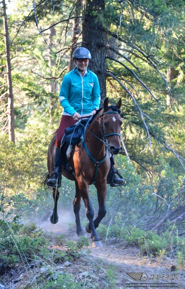
Photo credit http://www.tonyapermephotography.com

If you are not participating in this event, please use other trails.

Today's video of Grouse Ridge trails and lakes

6/21/2017

 
Picture
Enjoy this video of the Nevada County high country Grouse Ridge, June 20 footage of Penner, Rock, Lindsay, Carr, Feeley Lakes and more. This beautiful video will give you an idea of where you can hike, ride and camp in the high country this week. Looks like Carr and Feeley Lakes are reachable, and the road to Carr is open. Most of the rest are still a bit snow bound, and there are LOTS of downed trees on the trails. Video and drone footage by Juan Brown.

CLICK HERE to see the video!

Folsom Lake SRA beach trail still under water

6/21/2017

 
Picture
Because of the late snow melt, Folsom Dam is full and will continue to hold higher than normal runoff this year. That means the lower or beach trail between Sterling Pointe and Horsehoe Bar is under water and will be until further notice. Trail users have been spoiled during the past few years of drought where the lower trail was open most of or all year, but this summer closure is back to normal.

The upper trail, the Pioneer Express Trail, is open to hikers and horses.

Photo by Majestik Mirage

This week's heat wave and death on the trail

6/20/2017

 
Picture
Pretty dramatic title, but it needs to be repeated. You can die from the heat. This week's heat wave could push some of us over the edge from heat exhaustion into deadly heat stoke. We experienced trail users have heard it all before...hike in the cool mornings (what cool mornings this week?), keep hydrated, know the signs of overheating, etc. But there are a few things that can mean the difference between coming home for dinner or ending up in the hospital. Or worse.

HEAT EXHAUSTION
So that you don't tip over into heat stroke, this column is from Scouting Magazine.
Now let’s make a distinction: Heat exhaustion is different from heat stroke. This deals with the former, which can lead to the latter — but they are not the same thing. Heat stroke is a serious condition that can be fatal and demands urgent hospital care. (Recovery requires immediate full-body cooling to avoid permanent brain injury or death.)

Heat exhaustion, while serious, can be field-treated in most cases if you know what you’re doing.
Heat exhaustion is the body’s way of telling you that it's water- and salt-depleted, typically because of excessive perspiration without proper replenishment. There are numerous signs of the condition: profuse sweating (as the body tries to cool itself), dizziness, fatigue and muscle cramps. Other signs might be less obvious: general confusion, very dark yellow (or even brownish) urine, nausea and a rapid heart rate.

The first step in treating heat exhaustion is to stop, sit and cool down. Next, move to a cool(er) place. If you’re near a swimming hole, go for it. If not, move to a shady spot (try a north-facing slope).

Once you cease activity, rehydrate slowly while removing tight-fitting clothing. Water is a good choice. But because heat exhaustion might also be caused by mineral depletion, electrolyte-enhanced sports drinks are also effective. If a banana is available, eat one for added mineral replenishment. Salt tablets can also be dissolved in water, but don’t overdo it … you’re trying to rehydrate, not dehydrate. Rehydrate with a mouthful of liquid at a time. This should eventually lead to urination, a sign that the kidneys are functioning normally and the body is no longer fluid-depleted.

There are additional ways to treat heat exhaustion. Full-body immersion in cool water is ideal. If you have water to spare, cool the victim’s skin with dampened T-shirts. Also, fanning speeds up the skin-cooling effects of sweating. Use a map, book, magazine or hat. A few people fanning the overheated hiker can be helpful.

Recovery times vary for heat exhaustion. Don’t expect someone to take off down the trail after swallowing some Gatorade. Activity should be kept to a minimum. If you need to hike out, wait until it’s cooler and then take your time.Untreated Heat Exhaustion can rapidly turn into Heat Stroke. The factors that cause, raise the risk factor or can exacerbate heat exhaustion are the same for heat stroke. The main sign that someone is going into heat stroke when hiking is that their body temperature can reach 104 - 105 F and beyond at which point the hikers may exhibit personality changes, confusion and even go into a coma.

HEAT STROKE
Heat stroke is much more dangerous than heat exhaustion, and requires swift action, because the body’s core temperature has reach a life-threatening 105 degrees or higher. The main symptoms to look for with heat stroke are:
 - Skin red, hot to the touch
 - Irritability
 - confusion or unconsciousness
 - Feeling dizzy or lightheaded
 - Rapid heartbeat
 - Rapid and shallow breathing
 - Elevated or lowered blood pressure
 - Cessation of sweating
 - Headache
 - Nausea
 - Fainting (Often the first sign in older adults)

With heat stroke it is imperative that you get the victim to medical help immediately. The victim’s temperature needs to be lowered quickly. If you are in an area that is too far for swift medical help, you must move the individual to shade, loosen tight clothing, and have him drink small amounts of cool water. Pour water on them and increase cooling by fanning. If traveling in a group of three or more, send one for help. Do not leave the victim alone. Carefully monitor the victim to prevent a relapse.


If for any reason you or your trail partner is not recovering, don't hesitate to call 911.

More good tips:
For dog walkers
Care: How To Prevent Your Dog From Overheating On The Hiking Trail
<http://www.care2.com/causes/how-to-prevent-your-dog-from-overheating-on-the-hiking-trail.html>

Runner's World: How to avoid overheating on the run
<http://www.runnersworld.com/fuel-school/how-to-avoid-overheating-on-the-run>

For horses:
Equisearch: How to keep your horse cool on the trail
<https://www.equisearch.com/resources/eqcool396>

For hikers and all trail users:
Scouting: How to prevent and overcome heat exhaustion
https://scoutingmagazine.org/2015/04/how-to-survive-heat-exhaustion/

For bikers:
Active: Avoid Heat Stress When You Ride
<http://www.active.com/cycling/articles/avoid-heat-stress-when-you-ride-with-these-tips>

Poster from the Mayo Clinic.


Tahoe NF and YubaNet Photo Contest!

6/19/2017

 
Picture
The Tahoe National Forest's 2017 Photo Contest kicks off June 21--the first day of summer. This year, the Tahoe National Forest has partnered with YubaNet, a Nevada County-based online news outlet delivering news to the Sierra. 

WHAT:  
The 2017 Tahoe National Forest Photo Contest. We're looking for your best photographs of the Tahoe National Forest! Possible subjects:  wilderness; wildlife and plants; recreation; rivers and lakes; fire lookouts; landscapes; or whatever moves you! The prize for first place is two nights in the restored, historic U.S. Forest Service Sardine Fire Lookout. Second and third place winners will be treated to a guided tour on the Rock Creek Nature Trail in the spring.
WHEN:Photographs can be submitted starting June 21--the first day of summer--and continuing through September 30, 2017. Winners will be announced in October 2017.
WHO:Anyone can enter (except for current Tahoe National Forest employees)
WHERE:
Photos must be taken on the Tahoe National Forest

HOW:How to Submit a Photo:
  1. Submit photos by email to: tahoe_nf_comments@fs.fed.us with “Tahoe National Forest 2017 Photo Contest” in the subject line.
  2. Submit photos in JPEG format. Image quality must be high resolution (at least 300 dpi) with one side at least 3000 pixels.
  3. Provide a title and location of the photo.
  4. Only submit photos you yourself have taken.
  5. Photos must be received by September 30, 2017.
What Not to Do:
  1. Heavily alter or manipulate photos. Limited modifications are allowed with the intent and effect of producing a more natural looking and accurate photograph. Photo techniques such as HDR or long exposures are accepted.
  2. Break any laws or rules of federal lands.
  3. Anything unsafe.
  4. Photograph anything that is inappropriate, indecent or obscene.
  5. Add watermarks or logos.
What to Do:
  1. Enjoy the Tahoe National Forest!
  2. Submit your best photos.
  3. Tell your friends!

Read the full contest rules here!
Click here to print a Contest Flyer!

Go to the main Tahoe National Forest Photo Contest page HERE.

Photo 3rd place winner from 2016

Hoot Trail possibly closed for 19th Annual Wild West Endurance Ride this weekend

6/16/2017

 
Picture
Trail users should be aware that the 3-day 19th Wild West Endurance Ride in the Tahoe National Forest is starting today, Friday, June 16. The ride, which takes place on Friday, Saturday and ending Sunday, June 18. The equestrian ride will be held on the trails in and around Skillman Horse Camp and will be using multi-use trails, including the Pioneer, Omega, Burlington, Hallelujah, and the horses will be going uphill on the new Hoot Trail. The Hoot Trail is a two way trail, open to hikers, horses and bikers. All users to yield to uphill travel.
Because of the usage of the Hoot Trail by downhill bicyclists, for safety, the trail may be closed for two hours each day during the ride. Bikers should be aware and careful going downhill as more uphill horses than usual will be using the trail all weekend.

CLICK HERE to see the area's trail maps.
CLICK HERE to see more information about the Wild West Endurance Ride.

Map of the Hoot Trail
Picture

UPDATE: Auburn Bike Pump Park bisects Pioneer Express-Jedediah Smith National Trail, public comment period ends July 3

6/15/2017

 
Picture
UPDATE: Bureau of Reclamation Press Release
Mid-Pacific Region, Sacramento, Calif.
MP-17-089
Media Contact: Russell Grimes, 916-978-5100, rwgrimes@usbr.gov
Reclamation Releases Draft Environmental Documents for the Maidu Bike Project in Placer County
 
SACRAMENTO, Calif. – The Bureau of Reclamation has prepared a Draft Environmental Assessment/Initial Study (EA/IS) for the Maidu Bike Project located in Auburn, California. The Draft EA/IS details impacts from the construction and operation of a recreational bike park to be located near the Canyon View Community Center. The bike park would provide a variety of bike trails and tracks for various skill levels. The project would also include an ADA-compliant picnic area, restrooms and observation area adjacent to the existing Canyon View Community Center parking lot. Reclamation’s action would be to approve the project proposed by the Auburn Area Recreation and Park District. Auburn Area Recreation and Park District operates the facilities at Canyon View Community Center under a management agreement with Reclamation.  
 
The Draft EA was prepared in accordance with the National Environmental Policy Act and is available at https://www.usbr.gov/mp/nepa/nepa_projdetails.cfm?Project_ID=22689. If you encounter problems accessing the document online, please call 916-978-5100 or email mppublicaffairs@usbr.gov.
 
Written comments are due by close of business Monday, July 3, 2017, to Jamie LeFevre, Bureau of Reclamation, Mid-Pacific Region, 2800 Cottage Way, Sacramento, CA 95825. Comments may also be emailed to jlefevre@usbr.gov. For additional information or to request a copy of the Environmental Assessment, please contact LeFevre at 916-978-5035 (TTY 800-877-8339).

===================================
POSTED JUNE 15, 2017
A report (from the consultant on the project) on the Auburn Recreation District’s (ARD) planned bike park in Auburn estimates that its biggest days will attract 150 people during special events. School holidays and weekends are expected to draw about 100 visitors through the day and are considered peak-use days for the 9-acre site off Maidu Drive, states Dudek consulting business of Auburn.

ARD released a draft version of the study on Friday for public review and a 30-day comment period, starting June 2, 2017 and ending July 3, 2017. The board is to review and consider adoption of the study July 27 as part of the state environmental approval process.

To make a public comment to the U.S. District of Reclamation, the owner of the property
https://www.usbr.gov/mp/nepa/nepa_projdetails.cfm?Project_ID=22689
Public review and comment of the EA/IS begins June 2, 2017 and ends July 3, 2017.
Contacts:

Jaimie LeFevre
Phone: (916) 978-5035
Bonnie Van Pelt
Phone: (916) 989-7127

Added:
The Draft EA was prepared in accordance with the National Environmental Policy Act and is available at https://www.usbr.gov/mp/nepa/nepa_projdetails.cfm?Project_ID=22689. If you encounter problems accessing the document online, please call 916-978-5100 or email mppublicaffairs@usbr.gov.
Written comments are due by close of business Monday, July 3, 2017, to Jamie LeFevre, Bureau of Reclamation, Mid-Pacific Region, 2800 Cottage Way, Sacramento, CA 95825. Comments may also be emailed to jlefevre@usbr.gov. For additional information or to request a copy of the Environmental Assessment, please contact LeFevre at 916-978-5035 (TTY 800-877-8339).

**Draft Environmental Assessment /Initial Study
 This document states how ARD will address the trail issues, including the building of a by-pass trail adjacent to the new bike pump park, along the road.

Notice of Intent to Adopt a Mitigated Declaration
To make a public comment to ARD, the Lead Agency of the project:
Maidu Bike Park Project
Auburn Area Recreation and Park District (ARD)
123 Recreation Drive, Auburn, CA 95603
CONTACT:
Kahl Muscott, ARD District Administrator
(530) 885 - 8461 Ext. 102
info@auburnrec.com

Proposed Mitigated Negative Declaration

"The site for the bike park was OK’d in late 2013 by the district board and approval of the environmental review would allow the district to go out to bid on the project. District Administrator Kahl Muscott said Monday that site work could start in the summer or fall but that no target date for opening has been established.
Also necessary for moving forward, a similar environmental survey by property owner the U.S. Bureau of Reclamation is undergoing a 30-day public review.
The district’s environmental report discusses plans to continue public use of a foot trail that bisects the bike park site along a Placer County Water Agency canal. The trail, used for maintenance of the waterway as well as for public recreation, would be fenced from bike track activities but open for public use to travel through.
A bridge over the canal is also planned to link the two areas of the bike park. Cyclists would be blocked from riding through cross traffic on the trail by bollards and would instead walk there bikes across the bridge. The park would also be closed during special trails events such as the American River 50 endurance run.
Muscott said that plans are to have two other trails nearby to bypass the bike park.
Parking for cyclists bringing vehicles would be at an unused lot that was once part of the Auburn dam construction project. The lot is located below the Canyon View Community Center, which houses the district headquarters.
The most recent cost projection for the bike park is $175,000 but some of that total could come from volunteer labor and in-kind support, Muscott said.
The park would be open from dawn until dusk, with no lighting planned for nighttime hours.
The bike park will feature a pump track, jump course and several skills trails spread out over five acres on the site, just east of Canyon View Center."

A full copy of the environmental review is accessible on the district website http://www.auburnrec.com/

CLICK HERE to see original article in the Auburn Journal

Picture

Register for FREE Pacific Crest Trail Skills College in Truckee

6/15/2017

 
Picture
You’re invited to the annual Tahoe Trail Skills College near Truckee! This a free weekend event for local volunteers to learn about trail maintenance and stewardship. Beginners and experts alike can benefit from Trail Skills College courses like Working with Packers & Packstock, Waterbars & Checks, and Drainage Design & Drain Dips.
Trail Skills College is offered free of charge in an effort to inspire citizen stewardship of trails. In exchange for attending the training, we encourage you to volunteer at least 16 hours of work on trail projects in the coming year.

The 2017 Tahoe Trail Skills College is possible thanks to the U.S. Forest Service, California Alpine Club, and Hydro Flask.
When is it?   July 21 – 23, 2017
Where is it?   Near Truckee, California

Are meals and lodging provided? Car/tent camping will be available at no cost to all participants on Friday and Saturday. Meals will also be provided at no cost starting with breakfast on Saturday and ending with lunch on Sunday.

What’s the fitness level of Trail Skills College? he fitness level will vary depending on the classes you select during registration. However, all participants should be prepared to hike a minimum of 1-2 miles while carrying personal gear and tools. Participants should also be prepared for the hands on learning opportunities in many of these classes, resulting in 6-8 hours of active trail maintenance per day.

What classes are being offered? Most classes at this Trail Skills College will last two days (Saturday-Sunday) in order to provide enough time for projects in the field. The only one-day class is 306 Working with Packers & Packstock. Students in this class are encouraged to stay for dinner and camp Saturday evening, then depart Sunday after breakfast. There will not be a follow-up class on Sunday. We are not able to add students from Saturday’s 306 class to any of the two-day classes on Sunday.

Here are the class options:Saturday only:
  • 306 Working with Packers & Packstock (brand new course!)
Saturday-Sunday:
  • 100 Intro to Trail Maintenance – Intro to Scouting & Adopting
  • 201 Drainage Design & Drain Dips – 203 Waterbars & Checks
  • 203 Waterbars & Checks
  • Crosscut Saw Certification
How do I register?  Register here for 100, 201, 203, or 306.

Register here for Crosscut Saw Certification.

Can’t wait?  Don’t forget, you can learn new trail maintenance skills by volunteering on a PCTA trail crew any time. Most crews do not require any previous trail maintenance experience. Knowledgeable and experienced crew leaders are on site to teach you the necessary skills. Visit the online project schedule to find trail projects near you.

If you have questions about Trail Skills College, contact the Volunteer Programs Assistant at 916-285-1838 or volunteer@pcta.org.
CLICK HERE for registration form.

Sponsored by the U.S. Forest Service:
Picture

The Pacific Crest Trail Is Super Dangerous This Year

6/15/2017

 
Picture
California's banner Sierra Nevada snowfall plus a record number of hikers have kept local search and rescue teams very, very busy.
The Pacific Crest Trail doles out hazards in cruel ways. Thousands of hikers on the 2,650-mile trek face perils including rattlesnakes, exposure, corneal flash burns from snow glare, and heatstroke. But 2017 is shaping up to be one of the most frightening years in the national scenic trail’s history, thanks to the massive snowpack in the Sierra Nevada combined with the trail’s unprecedented popularity.
Just a couple of months into hiking season, thru-hikers are posting stories of near-death experiences. 
Jack Haskel, spokesman for the Pacific Crest Trail Association, is fielding calls and hearing stories “every week, if not every day” involving avalanches, falls on slippery slopes, exposure, and dunkings in chin-high creeks. “There was a pretty serious incident in which a hiker fell and punctured a lung,” he says. 

Sequoia and Kings Canyon national park staffers contacted Haskel about several recent medical evacuations by helicopter. One involved a hiker who fell near Forester Pass, the trail’s highest point, at 13,153 feet. In early June, Haskel issued a bluntly worded message on a 16,000-member Facebook page for PCT hikers. “I’m worried that someone will die,” he wrote. “It’s no joke…Do you have the fitness and skills to do this type of stuff safely?”

PCT thru-hikers usually begin from the southern terminus in Campo, California, near the Mexican border in late April or early May. This means that the first hikers have already breached the southern end of the Sierra Nevada, where winter snowfall, in certain high elevation spots, reached record highs: the overall snowpack in the Sierra is the deepest since 2011, according to California’s Department of Water Resources. California desperately needed that precipitation after an historic drought, but the same conditions have brought out the nasty and unpredictable side of the PCT. 

Record snowpack was reported at Sonora Pass, lower Carson Pass, and other high-elevation spots on or close to the PCT, according to Jeff Anderson, staff hydrologist for the snow survey department of the Natural Resources Conservation Service in Reno, Nevada. In June, Anderson and his team measured 180 inches of snow at Leavitt Lake at 9,600 feet, just east of the Sierra crest. “Given this rate, it is likely that this area will not be snow-free for fifty to a hundred more days,” he says.
In late May, thru-hiker and experienced mountaineer Brien Bower, a 25-year-old volcano climbing guide from Seattle, was walking near snowbound Glen Pass when he started checking for avalanche conditions. Suddenly, a large shelf of snow gave way and started sliding down, with Bower still standing on it. 

 “Looking up, I could see the rocks on the other side of the valley were quickly moving by,” Bower recalled. “I knew I was in an avalanche. All I could do was try to stay upright and in control.”  Bower slid 400 feet down the slope and fell down a 20-foot vertical drop. “I’m lucky it wasn’t 200 feet,” he said. Bower escaped without broken bones, though he was treated for dehydration and sunburn at a hospital in Fresno, but the near misses are piling up. 

Near the end of May, an Australian hiker whose trail name is “Thor” got swept away while attempting to ford Bear Creek near Selden Pass in the High Sierra. He tumbled and rolled in the water before swimming to shore, according to a video post uploaded by hiker Daniel Winsor on his “Professional Vagrant” page.

About a thousand miles into his hike, long-distance hiker Marcus Mazzaferri fell on a loose rock in a Yosemite creek, was swept into the current, and lost his pack in the water. “He was out by himself with no equipment and spent a night out,” Haskel says. “He was following his footprints back to the nearest road. It is a deeply concerning story.” In an account on Facebook, Mazzaferri described “sub-freezing temps” and doing jumping jacks and running around in circles to keep from freezing.  Understandably, he bailed out of the trail after making his way to safety. “I am truly lucky and grateful to be alive,” he wrote. 

It might not be such a problem if there weren't so many people on the trail. In the early 1990s, only 30 or so people completed the route every year. Compare that to last year, when the Pacific Crest Trail Association issued long-distance permits to 3,164 northbound long-distance hikers. (About 700 finished the trail.) The PCTA will not release the number of current thru-hikers until the end of this year, “but I would say the numbers are pretty similar to last year,” Haskel says. 

Some thru-hikers have attempted a “flip-flop” approach, which means breaking up the trail into strategic chunks rather than sticking to a continuous hike. Flip-flopping was no option for Brandon Toftner, a 28-year-old electrician from Columbus, Ohio, who vowed to take on a south-north through-hike no matter what. In late May, he was making his slow way up a steep ridge near Cottonwood Pass. Crampons didn’t help. One little slip sent him sliding 100 feet down a steep slope. Toftner self-arrested with his ice axe, a mere 10 feet away from the trees. “It scared me,” he said. “I would have been dead or have about a thousand broken bones.”

After getting off the trail at Kearsarge Pass above Lone Pine, Toftner decided to take a brief respite, but vowed to return soon. He said his experience in the United States Marine Corps from 2008 to 2012, with two deployments to Afghanistan, made him ready for anything the PCT might dish out. “It was all about completing a mission no matter what,” he explained. 
But Toftner changed his mind. In the end, he bailed out and booked a trip to a place that he thought would give him far less trouble than the PCT—the grizzly-populated wilderness of Denali National Park. 

Article by By: Dan White
Jun 16, 2017

PHOTO: Crossing a snow patch below Forester Pass. Photo: Junaid Dawud/Flickr

To see the original article in the Outside Magazine Online, CLICK HERE.


UPDATE: Where are the goat herds at Cronan Ranch this week?

6/10/2017


Read More
<<Previous

    Archives

    November 2023
    October 2023
    September 2023
    August 2023
    July 2023
    June 2023
    May 2023
    April 2023
    March 2023
    February 2023
    January 2023
    December 2022
    November 2022
    October 2022
    September 2022
    August 2022
    July 2022
    June 2022
    May 2022
    April 2022
    March 2022
    February 2022
    January 2022
    December 2021
    November 2021
    October 2021
    September 2021
    August 2021
    July 2021
    June 2021
    May 2021
    April 2021
    March 2021
    February 2021
    January 2021
    December 2020
    November 2020
    October 2020
    September 2020
    August 2020
    July 2020
    June 2020
    May 2020
    April 2020
    March 2020
    February 2020
    January 2020
    December 2019
    November 2019
    October 2019
    September 2019
    August 2019
    July 2019
    June 2019
    May 2019
    April 2019
    March 2019
    February 2019
    January 2019
    December 2018
    November 2018
    October 2018
    September 2018
    August 2018
    July 2018
    June 2018
    May 2018
    April 2018
    March 2018
    February 2018
    January 2018
    December 2017
    November 2017
    October 2017
    September 2017
    August 2017
    July 2017
    June 2017
    May 2017
    April 2017
    March 2017
    February 2017
    January 2017
    December 2016
    November 2016
    October 2016
    September 2016
    August 2016
    July 2016
    June 2016
    May 2016
    April 2016
    March 2016
    February 2016
    January 2016
    December 2015
    November 2015
    October 2015
    September 2015
    August 2015
    July 2015

    Categories

    All

    RSS Feed

Home
Contact
 Mother Lode Trails is YOUR local volunteer-run trail information and resource website. Here you can find
up-to-the minute information on trail alerts, links and trail news for Placer,  Yuba, and Nevada counties.
Mother Lode Trails is trademarked.