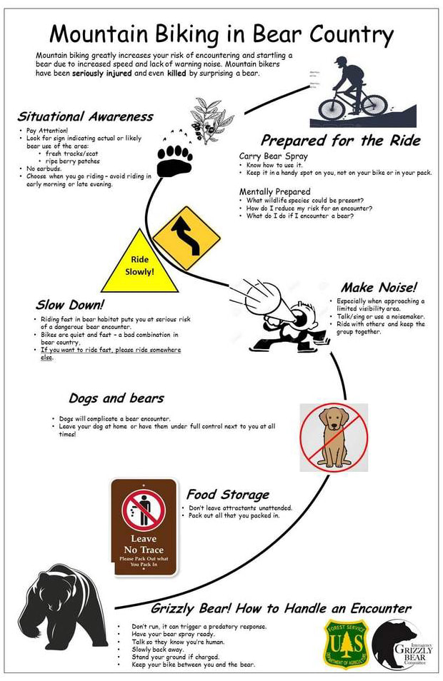
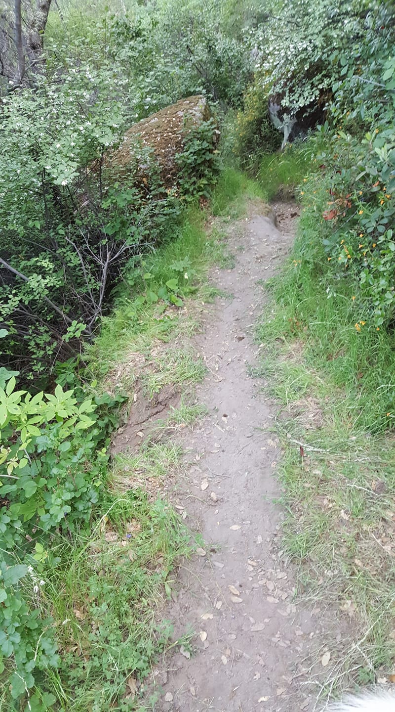
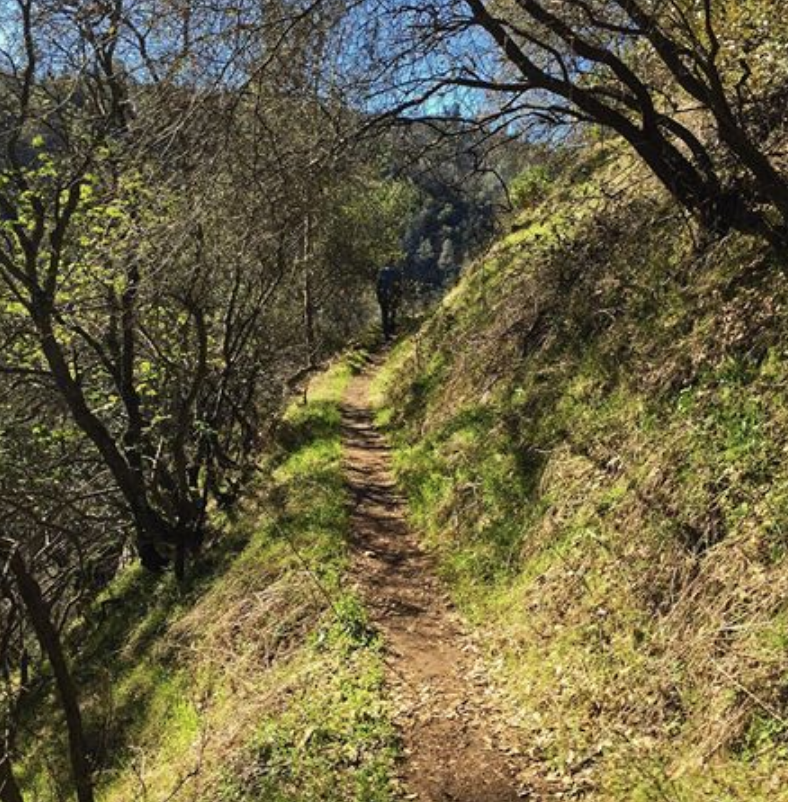
Bear experts warn that mountain biking in grizzly and black bear habitat can be dangerous, in large part because the biker might surprise a bear.
In June 2016, after a grizzly bear killed mountain biker Brad Treat in the Flathead National Forest near West Glacier, a board of review concluded: “The incident appears to be a surprise encounter with a bear due to the high speed and the lack of noise of bike travel, combined with a blind curve on a trail.” Evidence suggested the collision occurred so quickly that neither Treat nor the bear could avoid it.
Investigation suggested Treat collided with the bear and that Treat and his bike flipped over the grizzly and landed on the trail.
The board of review described mountain biking “as a recreational activity that involves increased risk and danger of surprise encounters with bears.”
Chris Servheen served as chairman of the board of review that investigated the Treat fatality. He retired in April 2016 as Grizzly Bear Recovery Coordinator for the U.S. Fish and Wildlife Service.
“Mountain bikers have the potential to compromise and diminish the value of grizzly bear habitat by displacing bears from bike trail areas,” Servheen said this week.
“Mountain bikers also put themselves at serious risk of surprise encounters with both black and grizzly bears because they travel quietly at high speed,” he said. “This is exactly what we tell people not to do when traveling in grizzly habitat.”
The board of review attributed the increased hazards associated with mountain biking in bear habitat to the tendency for the activity to be comparatively quiet and for bikers to travel at a higher speed than hikers. In addition, the board observed that mountain bikers tend to focus on the trail close to the bike “instead of looking ahead for bears, especially on single-track trails.”
A February 2016 article at singletracks.com observes, “Mountain biking is perhaps the most dangerous of the forms of recreating in bear country.”
Outdoors retailer REI was even more blunt in one installment of the company’s online “Expert Advice” feature: “It is not advisable to ride mountain bikes in grizzly country. Bikes cover ground quickly and quietly, meaning you could encounter a grizzly in a swift and startling manner. Such a meeting is a grave error in grizzly territory.”
Keith Hammer, chairman of the Swan View Coalition, has opposed ultra-marathons whose routes traveled through grizzly bear habitat. He is concerned also about new trails proposed by the Forest Service’s Taylor Hellroaring Project that could send mountain bikers into grizzly habitat and through miles of huckleberry patches.
“I’ve hiked my whole life and I’ve never had a black bear or a grizzly bear charge me,” Hammer said. “The two times I’ve been charged I was on a mountain bike.”
He said both occasions occurred when he was biking in the Krause Basin area east of Kalispell. One incident involved a black bear protecting cubs. The other involved a bear Hammer concluded was likely a grizzly. In that case, Hammer was traveling down a Forest Service road and heard a bear chasing him, with clacking of teeth and huffing.
Hammer sped up and escaped injury. He has not mountain biked since in the Krause Basin.
“I still hike through there. I don’t hesitate to. I have bear spray handy,” Hammer said. “On a bike, with both hands on the handlebars, you can’t grab your bear spray without crashing the bike.”
Anders Broste is an avid mountain biker and a board member for Flathead Area Mountain Bikers. He has a unique and hard-won perspective on recreation in grizzly country.
Broste was hunting in November off Trumbull Canyon Road when he startled a grizzly in thick brush and was attacked. Broste suffered numerous injuries, including a broken bone in his right arm, a broken fibula in his left leg, ligament and muscle tears, and more.
He did not blame the bear, noting the animal had reacted naturally to Broste’s surprise intrusion.
After extensive rehabilitation, Broste is mountain biking again.
He said he previously carried pepper spray when biking trails he considered “backcountry.” But he said his consideration of backcountry vs. frontcountry trails has changed as grizzlies continue to disperse and human development continues to expand into areas of wildlife habitat.
“We don’t think of these trails as backcountry trails and they should be treated that way,” Broste said. “The bears are everywhere.”
He said pepper spray ought to be included in a mountain biker’s gear when traveling in bear habitat.
“But you can only do so much to encourage people to do the right thing,” Broste said.
One point of discussion among regional mountain bikers focuses on how or where a rider should carry a canister of pepper spray. He said he has often stashed it in the frame-mounted rack intended to hold a water bottle. But people have observed that this location would not serve him if he got separated from his bike during an attack.
One bear spray manufacturer offers an adaptor that can secure a canister in a water-bottle rack.
Meanwhile, the Forest Service’s preferred alternative for the proposed Taylor Hellroaring Project northwest of Whitefish would construct about 40 miles of new trails, primarily in the Flathead National Forest. About 15 miles of trail would pass through huckleberry patches.
The board of review that studied the grizzly attack on Brad Treat provided recommendations intended to both communicate to mountain bikers the risks of biking in black bear and grizzly habitat and to suggest ways to reduce those risks.
The board observed: “Before new trails are opened to mountain biking in bear habitat, particularly grizzly habitat, there should be careful evaluation of the safety and reasonableness of enhancing mountain bike access in these areas where bear density is high.”
The board suggested that three characteristics of the proposed trails be evaluated. Among them was, “Evaluation of the productivity of bear foods along trail routes (i.e. does the trail traverse productive huckleberry fields or avalanche chutes?).”
Trail builders should also evaluate the potential use of seasonal trail closures “should the trail be opened for mountain bike use,” the board observed.
Servheen said recently that trail closures can be one way to reduce human-bear conflict but isn’t always effective.
“Our ability to close trails and manage such closures in grizzly habitat is poor at best,” he said. “So, avoiding such areas is best.”
Brian Peck is a Columbia Falls-based independent wildlife consultant with an expertise in wolves and grizzly bears. His clients have included National Audubon Society, Sierra Club, the Great Bear Foundation, Natural Resources Defense Council and WildEarth Guardians.
Peck’s comments to the Forest Service about the agency’s environmental assessment for the Taylor Hellroaring Project noted that the proposed alternative would pass through some 15 miles of huckleberry fields. He noted that this is “something bear managers have repeatedly warned against.”
He referenced, too, the trails’ proximity in places to streams and how the waterways’ noise can mask sounds and lead to surprise encounters between humans and bears.
“Clearly, this project’s trail systems are unnecessarily creating an accident waiting to happen, and need to be scrapped and completely re-thought,” Peck told the Forest Service.
In July, a mountain biker near Canmore, Alberta, collided hard with a black bear but escaped injury. There were buffalo berries in the vicinity, according to news reports.
Bill Mulholland, district ranger for Flathead National Forest’s Tally Lake District, acknowledged the trails “would be located in existing huckleberry [habitat] and some avalanche terrain.” He said “there are no plans for seasonal closures” of the trails and that “there will be educational signage installed.”
She noted that the environmental assessment for the Taylor Hellroaring Project describes plans for trail design and signage that could lessen the potential for human-bear conflict.
The environmental assessment also notes: “It is likely that the trail system would receive a high level of use soon after construction, as it is close to the town of Whitefish and would be tied into a larger system of trails that currently receive high levels of use.”
In addition to construction of new trails, the Taylor Hellroaring Project proposes interventions that would thin trees and conduct other landscape interventions intended to reduce the risk of catastrophic wildfire.
Broste said he believes the logging and thinning activities could reduce habitat impacts of trails.
Meanwhile, Servheen and others have noted that conflicts between humans and bears in bear habitat often end badly for the bears.
“Bears must live in these areas while humans are just visitors,” he said.

 RSS Feed