There is a new comprehensive overview of the map products available from the Forest Service.
FOREST SERVICE STANDARD MAP PRODUCTS
The Forest Service publishes a variety of map products to help you plan your next adventure or enjoy your next visit.
MAIN MAP PAGE
<https://www.fs.usda.gov/visit/maps>
National Overview Maps
We've released the next generation Interactive Visitor Map!
<https://www.fs.fed.us/ivm/index.html>
Visitor Map 2.0, provides the public with an online view of Forest Service roads, trails, recreation sites, wilderness areas, and wild & scenic rivers.
“A Guide To Your National Forests”
<https://www.fs.usda.gov/sites/default/files/GuideMap-2020.pdf>
is a free brochure showing locations of national forests and grasslands along with contact information.
Forest Visitor Maps, National Forest Atlas, and Wilderness Maps
<https://store.usgs.gov/filter-products>
These maps are available for purchase at the U.S. Geological Survey Store, many Forest Service offices and other retail outlets. Many Forest Visitor Maps are also available for purchase as georeferenced PDFs on Avenza, for use on mobile devices.
- Forest Visitor Maps for each national forest and grassland provide forest-wide information on attractions, facilities, services, and opportunities.
- National Forest Atlases are full color atlases, containing 8.5-inch by 11-inch topographic quadrangle maps at 1 inch to the mile scale and are available for many of the forests in California.
- Wilderness Maps are topographic maps that show natural features such as mountains, valleys, plains, lakes, rivers, and vegetation using contour lines depicting elevation gain or loss. Each map covers all or part of one wilderness area and the scale is generally 1 inch per mile (1:63,360).
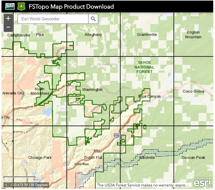
Topographic Maps
<https://data.fs.usda.gov/geodata/rastergateway/states-regions/states.php>
FSTopo is the Forest Service series of large scale topographic maps. FSTopo maps are 7.5 minute, 1:24,000-scale over the conterminous United States, and 15 minute X 20-22.5 minute, 1:63,360-scale over Alaska. These maps are available in several formats:
Geo-enabled PDFs and Geotiffs that contain both collar and non-collar editions in a single zipped file.
<https://data.fs.usda.gov/geodata/rastergateway/states-regions/states.php>
Hard copies
<https://store.usgs.gov/filter-products>
are available for purchase at some Forest Service offices, U.S. Geological Survey Store, and some retail outlets.
Motor Vehicle Use Maps
<https://www.fs.fed.us/recreation/programs/ohv/ohv_maps.shtml>
Motor Vehicle Use Maps identify those roads, trails, and areas designated for motor vehicle use are available one or more ways:
PDFs
Georeferenced PDFs through Avenza.
<https://www.avenza.com/avenza-maps/>
Printed maps at Forest Service offices.
<https://www.fs.fed.us/ivm/>
Other Map Products
FSGeodata Clearinghouse
<https://data.fs.usda.gov/geodata/>
The Forest Service Geodata Clearinghouse is an online collection of digital data related to forest resources. Through the Geodata Clearinghouse you can find datasets related to forests and grasslands. You can also find boundaries and ownership, natural resources, roads and trails, and datasets related to state and private forested areas such as insect and disease threat and surface water importance. The information includes map products you can download, raster data, and links to other resources.
National Forests and Grasslands produced maps
<https://www.fs.fed.us/maps/forest-maps.shtml>
Most national forests and grasslands offer online maps or instructions on how to obtain a printed map.
Map Services
Nationwide datasets are published as map services.
These map services are available:
In the REST directory
<https://apps.fs.usda.gov/arcx/rest/services/EDW>
On ArcGIS Online
<https://usfs.maps.arcgis.com/home/index.html>
On data.gov
<https://catalog.data.gov/organization/4ae51f6c-467a-4f9d-b40a-2c52e83c326a?publisher=U.S.+Forest+Service>
Dynamic Maps
ArcGIS Online Applications
ArcGIS Online is a collaborative, cloud-based platform that allows members of an organization to use, create, and share maps, scenes, apps, and data, and access authoritative basemaps and ready-to-use apps. Several National Map Viewer Applications have been created using AGOL and include:
Indian Lands Map Viewer
<https://usfs.maps.arcgis.com/apps/webappviewer/index.htmlid=fe311f69cb1d43558227d73bc34f3a32>
Land Status and Encumbrance Map Service Viewer
<https://www.fs.fed.us/land/ALPLandStatusandEncumbrance/>
Forest Service Communications Site Map
<https://www.fs.usda.gov/managing-land/special-uses/commsitemapviewer>
For more maps please visit ArcGIS Online.
<https://usfs.maps.arcgis.com/home/index.html>
Active Fire Mapping Program
<https://fsapps.nwcg.gov/>
The Active Fire Mapping Program is an operational, satellite-based fire detection and monitoring program managed by the Forest Service Remote Sensing Applications Center in Salt Lake City, Utah. The Active Fire Mapping program provides near real-time detection and characterization of wildland fire conditions in a geospatial context for the continental United States, Alaska, Hawaii and Canada. Detectable fire activity across all administrative ownerships in the United States and Canada are mapped and characterized by the program.
Roadless
Roadless maps
<https://www.fs.usda.gov/wps/portal/fsinternet/cs/main/!ut/p/z1/04_Sj9CPykssy0xPLMnMz0vMAfIjo8zijQwgwNHCwN_DI8zPwBcqYKAfDlZggAM4GuhHEaMfj4Io_MaH60fpYzEgzAdhgD5-E_w88nNT9QtyQyMMskwUAUTs3ig!/dz/d5/L2dBISEvZ0FBIS9nQSEh/?position=BROWSEBYSUBJECT&pname=Roadless-%20Maps&navtype=BROWSEBYSUBJECT&ss=119930&pnavid=151000000000000&navid=151150000000000&ttype=main&cid=null>
The 2001 Roadless Rule establishes prohibitions on road construction, road reconstruction, and timber harvesting on 58.5 million acres of inventoried roadless areas on lands managed by the agency. The intent of the rule is to provide lasting protection for inventoried roadless areas in the context of multiple-use management.
National Forest System Land Ownership and Boundary Information
<https://www.fs.fed.us/land/ALPLandStatusandEncumbrance/>
All these maps are available off of one NFS webpage - MAIN MAP WEBPAGE:
<https://www.fs.usda.gov/visit/maps>
FOREST SERVICE STANDARD MAP PRODUCTS
The Forest Service publishes a variety of map products to help you plan your next adventure or enjoy your next visit.
MAIN MAP PAGE
<https://www.fs.usda.gov/visit/maps>
National Overview Maps
We've released the next generation Interactive Visitor Map!
<https://www.fs.fed.us/ivm/index.html>
Visitor Map 2.0, provides the public with an online view of Forest Service roads, trails, recreation sites, wilderness areas, and wild & scenic rivers.
“A Guide To Your National Forests”
<https://www.fs.usda.gov/sites/default/files/GuideMap-2020.pdf>
is a free brochure showing locations of national forests and grasslands along with contact information.
Forest Visitor Maps, National Forest Atlas, and Wilderness Maps
<https://store.usgs.gov/filter-products>
These maps are available for purchase at the U.S. Geological Survey Store, many Forest Service offices and other retail outlets. Many Forest Visitor Maps are also available for purchase as georeferenced PDFs on Avenza, for use on mobile devices.
- Forest Visitor Maps for each national forest and grassland provide forest-wide information on attractions, facilities, services, and opportunities.
- National Forest Atlases are full color atlases, containing 8.5-inch by 11-inch topographic quadrangle maps at 1 inch to the mile scale and are available for many of the forests in California.
- Wilderness Maps are topographic maps that show natural features such as mountains, valleys, plains, lakes, rivers, and vegetation using contour lines depicting elevation gain or loss. Each map covers all or part of one wilderness area and the scale is generally 1 inch per mile (1:63,360).
Topographic Maps
<https://data.fs.usda.gov/geodata/rastergateway/states-regions/states.php>
FSTopo is the Forest Service series of large scale topographic maps. FSTopo maps are 7.5 minute, 1:24,000-scale over the conterminous United States, and 15 minute X 20-22.5 minute, 1:63,360-scale over Alaska. These maps are available in several formats:
Geo-enabled PDFs and Geotiffs that contain both collar and non-collar editions in a single zipped file.
<https://data.fs.usda.gov/geodata/rastergateway/states-regions/states.php>
Hard copies
<https://store.usgs.gov/filter-products>
are available for purchase at some Forest Service offices, U.S. Geological Survey Store, and some retail outlets.
Motor Vehicle Use Maps
<https://www.fs.fed.us/recreation/programs/ohv/ohv_maps.shtml>
Motor Vehicle Use Maps identify those roads, trails, and areas designated for motor vehicle use are available one or more ways:
PDFs
Georeferenced PDFs through Avenza.
<https://www.avenza.com/avenza-maps/>
Printed maps at Forest Service offices.
<https://www.fs.fed.us/ivm/>
Other Map Products
FSGeodata Clearinghouse
<https://data.fs.usda.gov/geodata/>
The Forest Service Geodata Clearinghouse is an online collection of digital data related to forest resources. Through the Geodata Clearinghouse you can find datasets related to forests and grasslands. You can also find boundaries and ownership, natural resources, roads and trails, and datasets related to state and private forested areas such as insect and disease threat and surface water importance. The information includes map products you can download, raster data, and links to other resources.
National Forests and Grasslands produced maps
<https://www.fs.fed.us/maps/forest-maps.shtml>
Most national forests and grasslands offer online maps or instructions on how to obtain a printed map.
Map Services
Nationwide datasets are published as map services.
These map services are available:
In the REST directory
<https://apps.fs.usda.gov/arcx/rest/services/EDW>
On ArcGIS Online
<https://usfs.maps.arcgis.com/home/index.html>
On data.gov
<https://catalog.data.gov/organization/4ae51f6c-467a-4f9d-b40a-2c52e83c326a?publisher=U.S.+Forest+Service>
Dynamic Maps
ArcGIS Online Applications
ArcGIS Online is a collaborative, cloud-based platform that allows members of an organization to use, create, and share maps, scenes, apps, and data, and access authoritative basemaps and ready-to-use apps. Several National Map Viewer Applications have been created using AGOL and include:
Indian Lands Map Viewer
<https://usfs.maps.arcgis.com/apps/webappviewer/index.htmlid=fe311f69cb1d43558227d73bc34f3a32>
Land Status and Encumbrance Map Service Viewer
<https://www.fs.fed.us/land/ALPLandStatusandEncumbrance/>
Forest Service Communications Site Map
<https://www.fs.usda.gov/managing-land/special-uses/commsitemapviewer>
For more maps please visit ArcGIS Online.
<https://usfs.maps.arcgis.com/home/index.html>
Active Fire Mapping Program
<https://fsapps.nwcg.gov/>
The Active Fire Mapping Program is an operational, satellite-based fire detection and monitoring program managed by the Forest Service Remote Sensing Applications Center in Salt Lake City, Utah. The Active Fire Mapping program provides near real-time detection and characterization of wildland fire conditions in a geospatial context for the continental United States, Alaska, Hawaii and Canada. Detectable fire activity across all administrative ownerships in the United States and Canada are mapped and characterized by the program.
Roadless
Roadless maps
<https://www.fs.usda.gov/wps/portal/fsinternet/cs/main/!ut/p/z1/04_Sj9CPykssy0xPLMnMz0vMAfIjo8zijQwgwNHCwN_DI8zPwBcqYKAfDlZggAM4GuhHEaMfj4Io_MaH60fpYzEgzAdhgD5-E_w88nNT9QtyQyMMskwUAUTs3ig!/dz/d5/L2dBISEvZ0FBIS9nQSEh/?position=BROWSEBYSUBJECT&pname=Roadless-%20Maps&navtype=BROWSEBYSUBJECT&ss=119930&pnavid=151000000000000&navid=151150000000000&ttype=main&cid=null>
The 2001 Roadless Rule establishes prohibitions on road construction, road reconstruction, and timber harvesting on 58.5 million acres of inventoried roadless areas on lands managed by the agency. The intent of the rule is to provide lasting protection for inventoried roadless areas in the context of multiple-use management.
National Forest System Land Ownership and Boundary Information
<https://www.fs.fed.us/land/ALPLandStatusandEncumbrance/>
All these maps are available off of one NFS webpage - MAIN MAP WEBPAGE:
<https://www.fs.usda.gov/visit/maps>


 RSS Feed