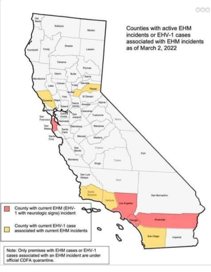
According to the California Department of Food and Ag State Veterinarian, the EHV-1 detections have significantly decreased. The cautionary recommendation to posted equine events and limit non-essential movement will expire on March 31 and not be extended.
|
EQUINE EVH QUARANTINE and TRAVEL RESTRICTION NOT EXTENDED
According to the California Department of Food and Ag State Veterinarian, the EHV-1 detections have significantly decreased. The cautionary recommendation to posted equine events and limit non-essential movement will expire on March 31 and not be extended. Yankee Jims is a relatively remote location. Despite its proximity to I-80 and the City of Colfax, the last leg of the journey takes you on a unimproved gravel road for several miles through the densely covered and steep slopes of Gold Country. If available, consider parking just prior to the old, narrow bridge and crossing by foot. (the bridge is almost 100 years old and is rated at 3 ton max capacity)
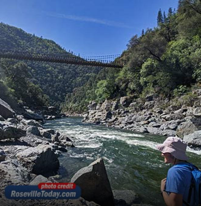
THE HIKE The trailhead begins on your left immediately after crossing, you can’t miss the stairs. Once you walk down the stairs, steer left and be sure to get a good look at the posted map and trail route. The first challenge on the trail is crossing Shirttail Creek, which requires steady-footing to either scramble across partially immersed boulders or braving the chilly waters to ford the slippery creek. We opted for the latter. (note: there are no clear trail markings, so cross safely wherever you can.) Once crossing the river, you’ll need to locate the trail again. Since the trail follows the river, heading to higher ground will help you locate it. It can be a bit of a scramble and hunt depending on where you cross Shirttail Creek. The trail is narrow and at times barely hangs onto the side of the hill with steep, slippery drop offs. Experienced and sure-footed hikers take note. At almost all times, you’ll be within site of the roaring North Fork. There are some nice views along the trail. TREACHEROUS SCRAMBLE The roundtrip is listed at around 4 miles. During our trek, there were downed trees that required climbing and portions of the trail that don’t instill much confidence even among a group of experienced hikers. Some spots offered little room for error. A simple misstep or slip could send you barreling down the rocky hillside. Approximately half way in, the trail became virtually impassible for those who don’t enjoy burrowing and barreling through the thickets. We turned back and encountered other hikers who had done the same. DESTINATION ALL IN ITSELF While not quite the hike we envisioned, we carefully made our way back and crossed over Shirttail Creek to douse ourselves at the river’s edge. The beautiful, rocky beach beneath Yankee Jims Bridge is a destination all in itself. A place to unwind and soak in some of Placer County’s amazing scenery. DIRECTIONS TO YANKEE JIMS In addition to hiking, Yankee Jims is a favorite summer swimming hole when conditions permit. The North Fork of the American River is fed by snowmelt and precipitation. Conditions and risks can vary greatly throughout the year, so use wise judgement when visiting and enjoying this slice of California paradise. Click HERE to read the full story and see photos in Roseville Today. Here are April's trail events and their websites for more information. For safety, consider hiking and riding alternate trails on these dates:
4/2/2022 - American River 25/50 mile run Folsom to Auburn/Cool/Auburn 4/23/2022 - Canyons 50k and 100k run Auburn to Foresthill to Devils Thumb ending at China Wall OHV staging 4/23/2022 - American River Classic Endurance Ride 25 mile and 50 mile horse event, Folsom to Auburn/Cool/Auburn Equestrian Staging area 4/30/2022 - Folsom Lake 50k run out and back Folsom Point-Salmon Falls (Photo credit from Folsom Lake run website) Reservations are required on all weekends.
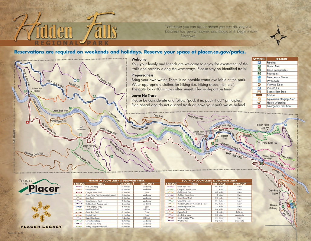
2022 HIGH USAGE DATES: In addition, the following days during 2022 will require a parking reservation: 1/1, 1/17, 2/21, 4/11 through 4/22, 5/30, 7/4, 9/5, 10/10, 11/11, 11/24 through 11/25, 12/19 through 12/31. Go here for RESERVATIONS https://www.placer.ca.gov/6106/Hidden-Falls-Regional-Park CLICK HERE FOR TRAIL MAP PDF WHERE CAN I CHECK THE CLOSURE STATUS BEFORE MY VISIT TO HIDDEN FALLS? Notifications will be posted to the following website: https://www.placer.ca.gov/6106/Hidden-Falls-Regional-Park or by calling (530) 886-4901. You may also check our social media sites for updates. HOW WILL CLOSURE DAYS BE DETERMINED? Staff will determine extreme fire weather days in consultation with weather and fire officials and would generally coincide with conditions that prompt Red Flag and Excessive Heat warnings. HOURS OPEN The park is open from sunrise to sunset daily. Specific opening and closing times are posted daily by park rangers at the site. Please note closure information and exit the park before closing time. CONTACT Placer County Department of Parks and Open Space Phone: (530) 886-4901 Email: [email protected] Amenities
This event will be the first ever FOLSOM 100-mile ultramarathon circumnavigating Folsom Lake.
The Folsom 100 will start from Granite Bay state recreation area in the five percent parking lot at 5:00 am on May 14th, 2022. Runners will have 34 hours to complete the 100-mile loop around Folsom Lake. You will be starting from Granite Bay and traveling through, Loomis, Auburn, Cool, Salmon Falls, El Dorado Hills, Folsom Point and back to Granite Bay! There are combined large sections of the other races (Meat Grinder, Snowberry, Red Dragon, and Dead Truck) into one route. The 50-mile race will end at the Skunk Hallow Parking lot in Pilot Hill. The 100-mile 2-person relay switch out will also take place at Skunk Hallow Parking lot in Pilot Hill. AID STATIONS:
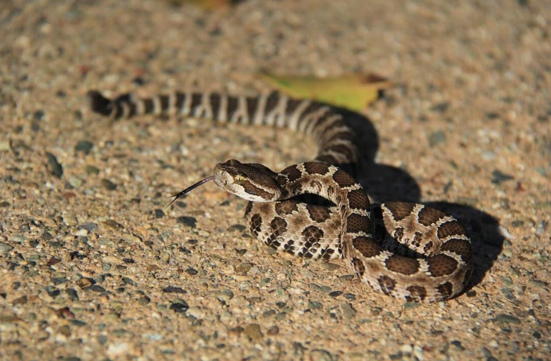
https://www.ssmountainracing.com/folsom100 Photo Credit: Folsom 100 - SS Mountain Racing Rattlesnakes are coming out of their dens, basking in the sun, and becoming more active - this is a full month early. Today one was seen on Olmstead Loop.
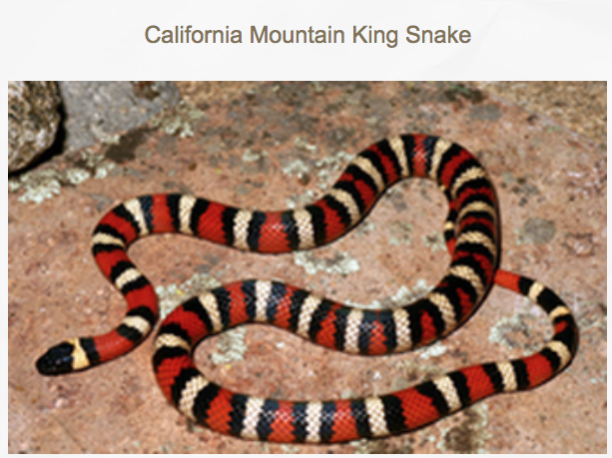
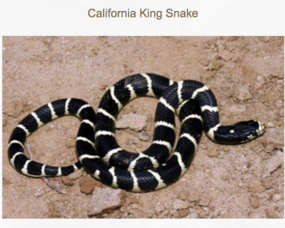
Keep an eye out on the trails below 1500 feet, especially at Cronan Ranch, Folsom Lake SRA, Auburn SRA. In our area, rattlesnakes bite hikers, bikers, runners, dogs, and horses every year, usually starting in April. This year, starting now, in March. - Keep your dogs ON LEASH so they don't get bitten. Rattlesnake avoidance training is available all year round. See trainers online, such as "Get Rattled." - Many horses will alert you to snakes - equestrians should really listen to their horses who can hear and smell them way before their riders can. - Wear long loose pants and high boots. - STAY on the trails. It's almost impossible to see the snakes in high grass. - Mt. bikers, slow down, so you don't run over them (and get bit in the process). SNAKE FACTS Most people bitten by rattlesnakes have inadvertently stepped or ridden over them. Snakes detect movement by sensing vibrations in the ground. Their eyes see well even in low light. Rattlesnake bites can be dangerous but are very rarely fatal to humans. With proper medical treatment, including antivenin, bites are usually not serious. Rattlesnakes can strike 2/3rds their length, and they are wonderfully camouflaged in the same color grass. NOT ALL RATTLE Young rattlesnakes do not yet have their rattles, though they are as dangerous as adults, according to the National Park Service at Yosemite. Furthermore, some adults may lose their rattles, so it is a good idea look out for the triangular head. (In Folsom Lake, for example, rattlesnakes that rattle get killed, those that don't...don't. Meaning that after several generations, we have many families of silent snakes.) After the rattle, rattlesnakes’ most distinctive physical feature is their triangular head. Also, they have vertical pupils, like cat’s eyes. RATTLESNAKES ARE LOCAL Generation after generation of rattlesnake will use the same dens, sometimes the same den for more than 100 years. Upon leaving their dens, they like to sun themselves on rocks and other open places. Though they are not nocturnal, in the hot summer months they may be more active at night. CALIFORNIA KING SNAKES ARE GOOD SNAKES! Despite their venom, rattlesnakes are no match for California King snakes, which are fond of putting them on their dinner menus. DON'T KILL CALIFORNIA KING SNAKES! (pictures below) Due to the equine EHM - EHV-1 outbreak in California, the water trough at the Sterling Pointe Equestrian Staging in Placer County will be empty until further notice. They are taking precautions as directed by the CDFA.
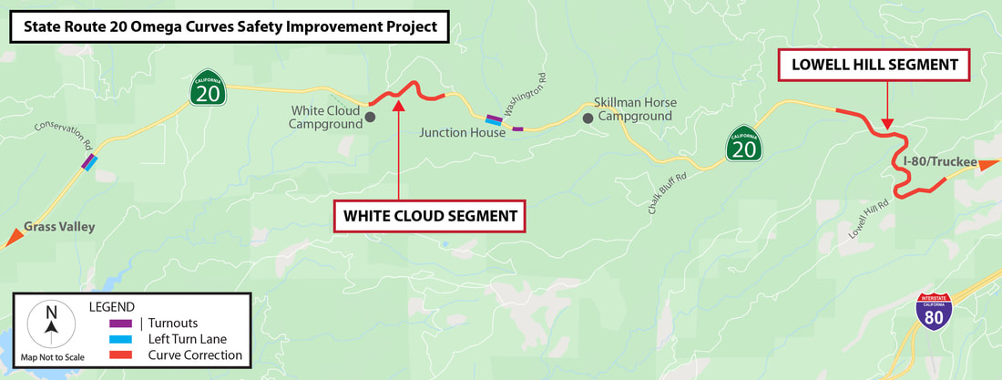
The CalTrans Omega Curves Safety Improvement project is starting March 2, 2022. Caltrans is beginning vegetation removal for State Route 20 Safety Project. The project will be adding turnouts, designated turn Lanes and reducing curve radii.
READ THE COMPLETE PRESS RELEASE HERE. NEVADA COUNTY – Caltrans is beginning vegetation removal Wednesday, March 2 on State Route 20 (SR-20) in Nevada County prior to the start of major construction work on the Omega Curves Safety Improvement project. The $62.5 million Omega Curves project aims to improve safety and reduce collisions on SR-20 by realigning curves on two non-contiguous segments near White Cloud and Lowell Hill, widening shoulders, improving the highway’s sight distance and adding designated left turn lanes near Conservation Road and Washington Road. The project is anticipated Monday through Friday from 7 a.m. to 5 p.m. While much of the work will occur in shoulder areas, occasional one-way traffic control will be required through March. Motorists should expect delays of up to 20 minutes or up to 30 minutes for larger trees. STARTING MARCH Anticipated vegetation work for this month is scheduled in order at the following locations: - Between the White Cloud Campground and Shake Hill Road - Prior to Last Chance Mine Road and past Lowell Hill Road - Near Conservation Road and Pine Needle Lane - Near Washington Road and Junction House - Near the Skillman Horse Campground STARTING APRIL Granite Construction, Inc. of Sacramento is the prime contractor for the safety project, which is scheduled to start major construction in mid-April. The project is expected to be finished in fall 2023. To receive Omega Curves project updates via email, please contact Public Information Officer Raquel Borrayo at <[email protected]> or at (530) 701-5209. READ THE COMPLETE PRESS RELEASE HERE. PASS PROVIDES FREE ACCESS TO 200+ STATE PARKS
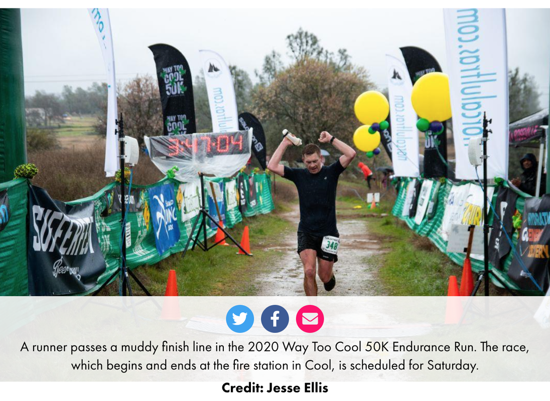
SACRAMENTO, Calif. — California State Parks and the California Department of Social Services (CDSS) have made it easier for CalWORKs families to receive a free annual, vehicle day-use pass valid at 200+ state parks and beaches. Now, families receiving CalWORKs can complete the application on their smartphone in just minutes. By simplifying the application process, more Californians will have access to the outdoors, regardless of their zip code. Four of every 10 Californians have no access to open space within walking distance of their home and six of every 10 Californians live in park-poor neighborhoods. The improvements to the Golden Bear Pass Program help advance the “Outdoor Access for All” initiative championed by Governor Gavin Newsom and First Partner Jennifer Siebel Newsom and the recently launched “California Outdoors for All” initiative. This effort expands outdoor access to all Californians through focused investments in open space infrastructure, outdoor programming, and improvements to permit applications, with a priority to expanding access in underserved communities. “Improving access to nature is a crucial public health tool to ensure Californians of all ages and backgrounds are healthy in mind and body,” said California First Partner Jennifer Siebel Newsom. “Through the state’s renewed efforts to raise awareness of the Golden Bear Pass for eligible Californians, we are taking a significant step forward to advance equitable access to the great outdoors and California’s awe-inspiring and unparalleled state parks system.” The Golden Bear Pass Program was created in 1977 and is being relaunched with the goal to directly notify approximately 300,000 families receiving CalWORKs about their eligibility and overall health benefits of spending time in the outdoors. The revamp of the program is part of a greater push by the Newsom Administration to innovate government to work better for the people including connecting Californians directly with state resources in an efficient and convenient way. The update to the program includes moving the application form online and removing the need for families receiving CalWORKs to compile documentation and mail the package, while also reducing the administrative burden on families to verify eligibility as CDSS will be assuming that role. “California continues to invest in the health and wellbeing of families receiving CalWORKs through increases in grants, support through the Home Visiting Initiative, and targeted outreach efforts to connect families with critical tax benefits, such as the child tax credit,” said CDSS Director Kim Johnson. “The Golden Bear Pass is yet another resource for families receiving CalWORKs, providing free access to California’s rich and beautiful state parks. Spring and summer are upon us, and it’s my hope that families receiving CalWORKs are able to get out, explore, and enjoy all that our beautiful parks and beaches have to offer.” The 2021/22 State Budget included initiatives to advance equitable access to state parks and open spaces for all Californians. A $9.1 million one-time General Fund investment was included in the budget to launch a state parks pilot to expand parks pass distribution, especially for youth in disadvantaged communities. The pilot includes a “California State Park Adventure” program that provides free day use passes for fourth graders and their families, a California State Library Pass, and the revamped Golden Bear Pass Program with CDSS. Under the library pass program, scheduled to launch in April, State Parks will be providing physical passes to every public library in the state for checkout by library patrons. “Everyone deserves to have access to the benefits of spending time in the outdoors,” said California State Parks Director Armando Quintero. “With the support of the Newsom Administration and Legislature, disadvantaged communities and youth can now more easily create memories with family and friends, connect with their communities, be active, and support healthy emotional and physical well-being by visiting California’s State Park System for free. Welcome.” The Golden Bear Pass is valid for vehicle day use at 200+ park units of the California State Park System operated by State Parks. It is not valid at units operated by federal and local government, private agencies or concessionaires. Also, the pass is not valid for per-person entry or tour fees (such as museums), boat use, camping, group use or sites, special events, additional/extra vehicle fees, sanitation disposal use or for supplemental fees. For more information on the State Park Pass Programs, please visit parks.ca.gov/CaliforniaOutdoorsForAll. CalWORKs families can find information on the Golden Bear Pass Program at cdss.ca.gov/GoldenBearPass. California State Parks provides for the health, inspiration and education of the people of California by helping to preserve the state’s extraordinary biological diversity, protecting its most valued natural and cultural resources, and creating opportunities for high quality outdoor recreation. https://www.parks.ca.gov/NewsRelease/1063 More than 600 athletes from around the world will race in NorCalUltras’ 32nd annual Way Too Cool 50K Endurance Run on Saturday in Cool.
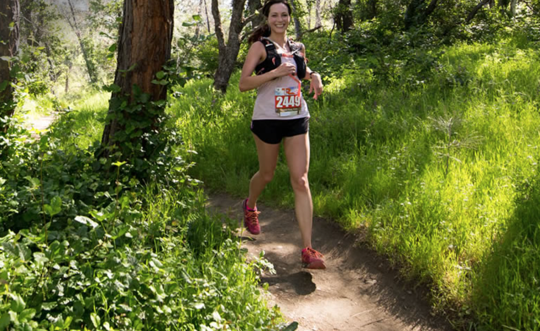
This year, 273 women and 415 men will cross the starting line near the fire station in Cool at 8 a.m. Saturday. Runners are expected to finish the race between 11 a.m. and 4:30 p.m. From the Cool Fire Station, runners complete an eight-mile loop and return to the fire station finish area via the Altra Fan Zone. From miles 8 to 13, runners will pass by Pointed Rocks Meadow and head north on the Western States Trail. From miles 20.5 to 26, participants will run from Auburn Lake Trails to Goat Hill. The final challenge takes place within miles 26 and 31.1, where athletes will follow Wendell T. Robie Trail and return to the Cool Fire Station. The Way Too Cool 50K Endurance Run course is 98 percent single-track trails with no two-way traffic. The course includes spectator access at the start line, mile 8 and at the Cool Fire Station at 7200 St. Florian Ct., five aid stations, volunteers and professional race timing by Capital Road Race Management. This year’s race beneficiary is the California Conservation of Trails which supports the Folsom Lake SRA Mounted Patrol. For more information, visit wtc50k.com. To see the full original article and more photos in Gold Country Media, CLICK HERE. |
Archives
July 2024
Categories |

 RSS Feed