Yankee Jims is a relatively remote location. Despite its proximity to I-80 and the City of Colfax, the last leg of the journey takes you on a unimproved gravel road for several miles through the densely covered and steep slopes of Gold Country. If available, consider parking just prior to the old, narrow bridge and crossing by foot. (the bridge is almost 100 years old and is rated at 3 ton max capacity)
THE HIKE
The trailhead begins on your left immediately after crossing, you can’t miss the stairs. Once you walk down the stairs, steer left and be sure to get a good look at the posted map and trail route. The first challenge on the trail is crossing Shirttail Creek, which requires steady-footing to either scramble across partially immersed boulders or braving the chilly waters to ford the slippery creek. We opted for the latter. (note: there are no clear trail markings, so cross safely wherever you can.)
Once crossing the river, you’ll need to locate the trail again. Since the trail follows the river, heading to higher ground will help you locate it. It can be a bit of a scramble and hunt depending on where you cross Shirttail Creek.
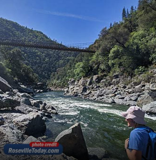
The trail is narrow and at times barely hangs onto the side of the hill with steep, slippery drop offs. Experienced and sure-footed hikers take note. At almost all times, you’ll be within site of the roaring North Fork. There are some nice views along the trail.
TREACHEROUS SCRAMBLE
The roundtrip is listed at around 4 miles. During our trek, there were downed trees that required climbing and portions of the trail that don’t instill much confidence even among a group of experienced hikers. Some spots offered little room for error. A simple misstep or slip could send you barreling down the rocky hillside.
Approximately half way in, the trail became virtually impassible for those who don’t enjoy burrowing and barreling through the thickets. We turned back and encountered other hikers who had done the same.
DESTINATION ALL IN ITSELF
While not quite the hike we envisioned, we carefully made our way back and crossed over Shirttail Creek to douse ourselves at the river’s edge. The beautiful, rocky beach beneath Yankee Jims Bridge is a destination all in itself. A place to unwind and soak in some of Placer County’s amazing scenery.
DIRECTIONS TO YANKEE JIMS
In addition to hiking, Yankee Jims is a favorite summer swimming hole when conditions permit. The North Fork of the American River is fed by snowmelt and precipitation. Conditions and risks can vary greatly throughout the year, so use wise judgement when visiting and enjoying this slice of California paradise.
Click HERE to read the full story and see photos in Roseville Today.
THE HIKE
The trailhead begins on your left immediately after crossing, you can’t miss the stairs. Once you walk down the stairs, steer left and be sure to get a good look at the posted map and trail route. The first challenge on the trail is crossing Shirttail Creek, which requires steady-footing to either scramble across partially immersed boulders or braving the chilly waters to ford the slippery creek. We opted for the latter. (note: there are no clear trail markings, so cross safely wherever you can.)
Once crossing the river, you’ll need to locate the trail again. Since the trail follows the river, heading to higher ground will help you locate it. It can be a bit of a scramble and hunt depending on where you cross Shirttail Creek.
The trail is narrow and at times barely hangs onto the side of the hill with steep, slippery drop offs. Experienced and sure-footed hikers take note. At almost all times, you’ll be within site of the roaring North Fork. There are some nice views along the trail.
TREACHEROUS SCRAMBLE
The roundtrip is listed at around 4 miles. During our trek, there were downed trees that required climbing and portions of the trail that don’t instill much confidence even among a group of experienced hikers. Some spots offered little room for error. A simple misstep or slip could send you barreling down the rocky hillside.
Approximately half way in, the trail became virtually impassible for those who don’t enjoy burrowing and barreling through the thickets. We turned back and encountered other hikers who had done the same.
DESTINATION ALL IN ITSELF
While not quite the hike we envisioned, we carefully made our way back and crossed over Shirttail Creek to douse ourselves at the river’s edge. The beautiful, rocky beach beneath Yankee Jims Bridge is a destination all in itself. A place to unwind and soak in some of Placer County’s amazing scenery.
DIRECTIONS TO YANKEE JIMS
In addition to hiking, Yankee Jims is a favorite summer swimming hole when conditions permit. The North Fork of the American River is fed by snowmelt and precipitation. Conditions and risks can vary greatly throughout the year, so use wise judgement when visiting and enjoying this slice of California paradise.
Click HERE to read the full story and see photos in Roseville Today.
 RSS Feed