 Heads up for those who ride at Olmstead Loop area!
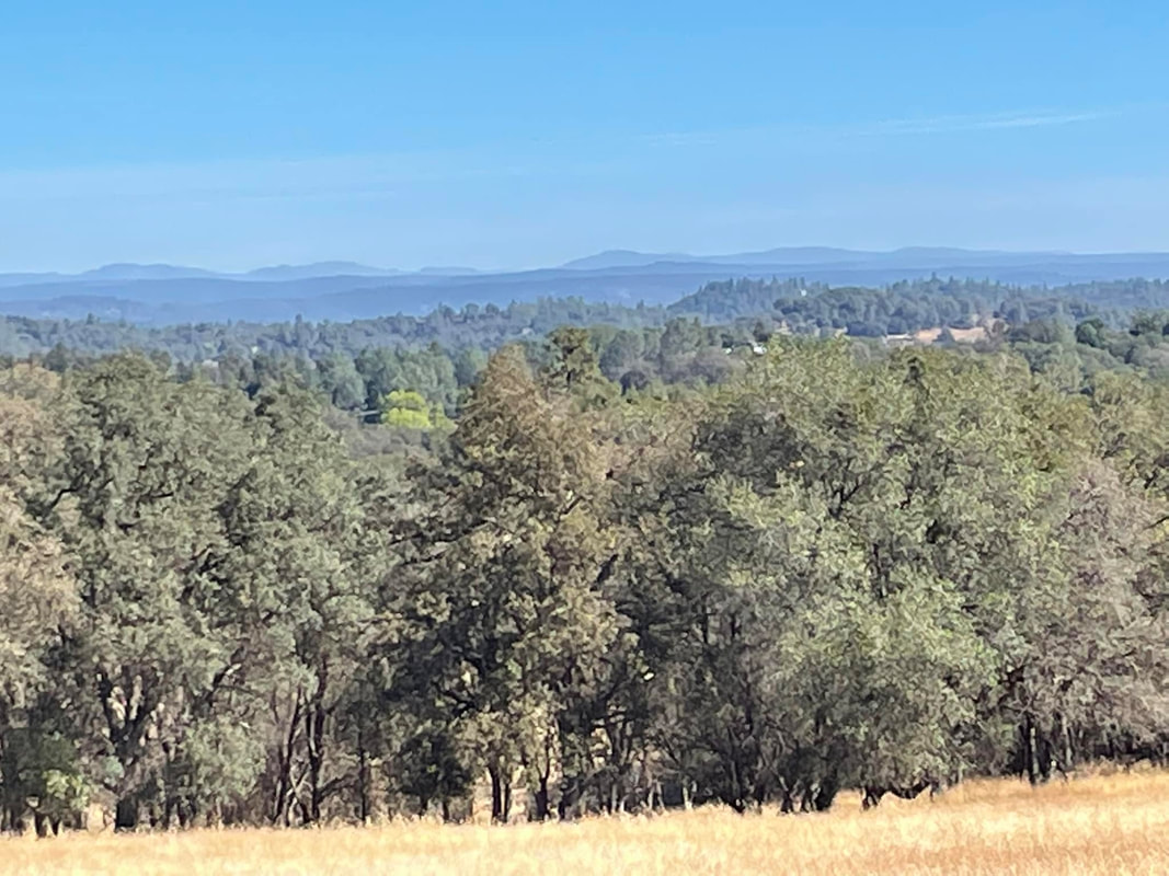
Wildfire services will be working on shaded fuel breaks for at least the next two weeks. They will be running chippers and pruning up trees. Be alert. They will be closing the areas where they are working and equestrians have requested them to place signage around to notify riders.  Sierra Pacific Industries, the state’s largest private-property owner, has reopened for recreation most of the 2 million acres of forest lands it manages for timber and timber harvesting in California, effective on Friday last week. Map show what is typical of their holdings in Grouse Ridge area. Recent rains prompted the decision to reopen most SPI forest lands in California, which had been closed due to extreme fire dangers since July 1. Closures will remain in place on SPI forest lands in the vicinity of recent wildfires to ensure the safety of crews working to restore and reforest lands impacted by those fires, and for public safety near those burn scars, SPI communications staff said last week. “Protecting forest lands from catastrophic wildfires is a commitment that SPI takes seriously,” Andrea Howell, a designated SPI spokeswoman, said in prepared remarks. “We are grateful the recent rains improved conditions to facilitate the reopening of our lands for responsible recreation.” Public access policy for SPI allows hunting and other recreation on most of its California forest lands. Overnight camping, campfires and smoking are still prohibited. Motor vehicles are restricted in many areas for resource protection and public safety concerns. In addition to the remaining wildfire closures, some SPI lands will be closed for active logging, existing leases, wildlife protection and other considerations. Fire season is not over, SPI communications staff emphasized. Their point was underscored early Monday when a fire broke out at the SPI plant on Perri Cone Road between Jamestown and Chinese Camp. Sierra Pacific Industries owns and manages more than 2.4 million acres of timberland in California, Oregon, and Washington and is one of the largest lumber companies in the nation. SPI’s land holdings include about 2 million acres in California. In late June, SPI said it was closing its lands in California due to extreme drought conditions and increasing risks of wildfires. “Despite some of the late spring rains, California is experiencing the driest conditions it has had in 1,200 years,” Howell said in late June. SPI closed all of its lands to the public last year on June 21 and reopened them in early October. In 2020, the company closed them in early September and reopened them in early November.  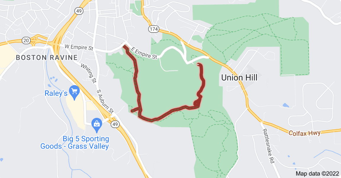 UPDATE 9/22/22
A sign at Penn Gate yesterday said the closure of the Hardrock Trail has been bumped to Oct. 18. Meaning the trail is open now and won't close until Oct. 18. UPDATE 7:15 PM: A Empire Mine SHP representative said they are starting to work on the mitigation of the Sand Dam. Trail will be closed at access points due to heavy equipment and trucks. For safety reasons, it is advised that trail users assume the Hardrock is closed. POSTED 4:00 PM Riders and hikers have spotted this sign at Empire Mine. So far, no official posts from State Parks, but it is assumed that the proposed tree work is commencing. They have about 100 trees marked to come down. As soon as we hear more, it will be posted. UPDATE: Foresthill USFS area Tevis trail CLOSED until Jan. 1, 2023 because of Mosquito Fire9/18/2022
 SEPT. 18 UPDATE
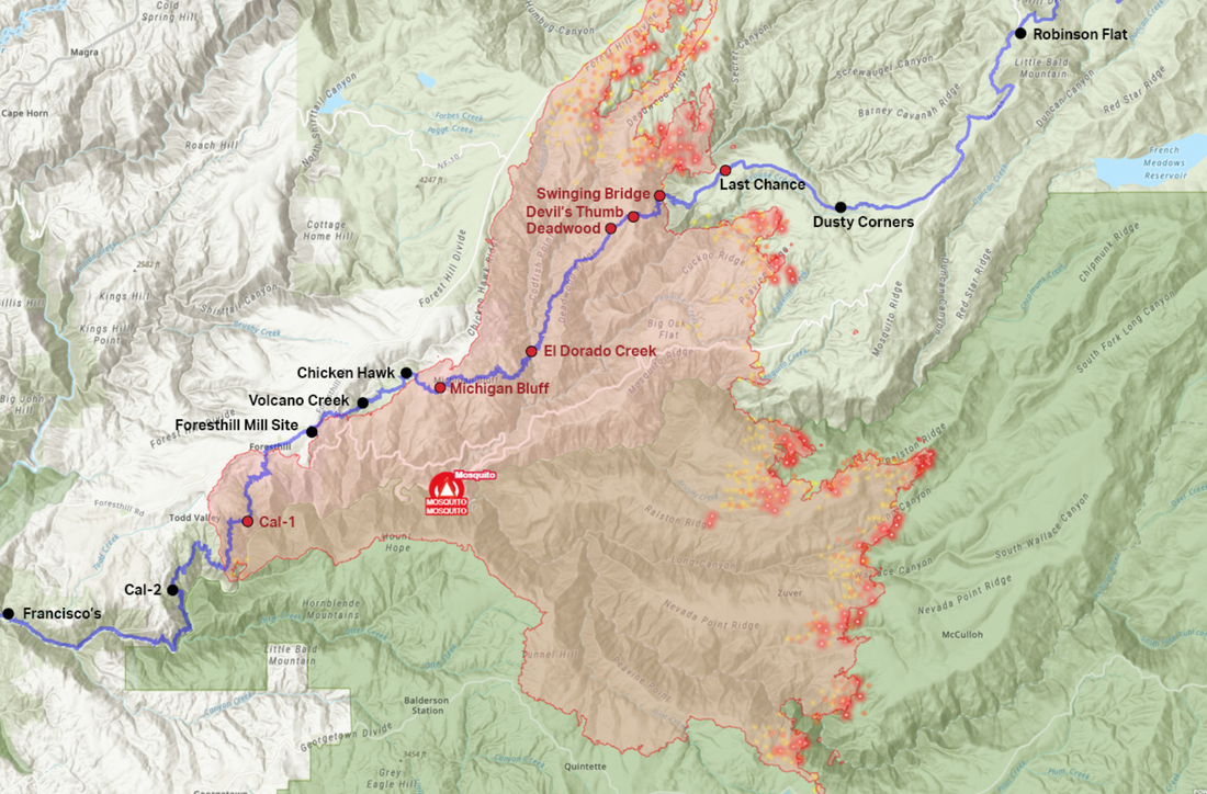
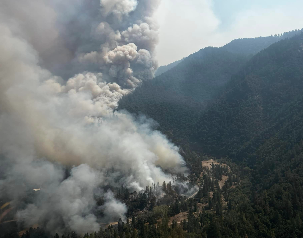
As many of you know, the middle section of the 100-mile WS Trail, including the canyons and Cal-1/Dardenelles west of Foresthill, was burned by the Mosquito Fire. As of writing, this fire continues to burn along the eastern perimeter, measured at nearly 75,000 acres and 34% contained. There are more than 3,700 personnel assigned to the fire and dedicated to getting it contained by mid-October. As a result of the damage sustained from the devastating fire, the Foresthill USFS District lands are closed to the public until January 1, 2023. This district manages the lands from the top of Palisades Ski resort (formerly Squaw Valley) to the western border of the town of Foresthill. This section of forest includes approximately 60 miles of the WS Trail. Prior the fire, the WSTF had been meeting with the Foresthill Ranger District, Tahoe National Forest office of USFS regarding the trail maintenance and improvements that we started before this year’s 2022 Tevis event. As the Tahoe National Forest District lands open up, WSTF—and its sister event the Western States Endurance Run—will access all available funds to work with the USFS to recondition the fire-affected trail. There should be opportunities for additional funding to restore areas hardest hit during the Mosquito Fire. We hope to be able to combine forest restoration funding with WSTF monies to resume the work we began this summer. The timeline of this work is not yet known until the Mosquito Fire is contained. WSTF crews hope to get to work this winter on some of the lower sections of the trail after the district opens back up in January. This is huge and dangerous fire affected many entities, property, people and the animals they love dearly. The west end of Michigan Bluff was particularly hard-hit. Thankfully evacuations are gradually being lifted as areas are deemed safe. All of us who love this historic Ride have a huge task ahead of us to restore this trail. We will be stronger together on the other side of this devastating event, however long that takes. If you would like to help with the Western States Trail Reconditioning Project, please click here to find out how. ================================ POSTED SEPT. 12, 2022: From the Tevis Trail Facebook page Sept. 12, 2022: WST - yellow highlight KS - Kaput Spring DW - Deadwood vet check DT - Devil's Thumb aid area SB - Swinging Bridge LC - Last Chance vet check Mosquito Fire - Monday Sept 12th - 1 pm - 46,587, 10% contained Impacts to the WST: * The fire has burned over approximately 12 miles of the WST between Devil's Thumb and Chicken Hawk vet check. The fire is still making its way northwards in El Dorado Canyon, and fire fighters are continuing to put in indirect containment lines on the north end of Deadwood Ridge to the west to try and tie the fire back over to Foresthill Rd. * Fire fighters have been up at Robinson Flat, moving down Rd 43, and over towards Last Chance. They have put in a dozer line along the WST from Rd 43 all the way to where the trail drops into the canyon at Pacific Slab Mine after leaving Last Chance. This is partially the old dozer line from when that area burned during the American Fire in 2013. They were in contact with ranchers to get the cows moved out of that area. There was a recent scanner report of road damage to Rd 43 (the dirt road the Ride uses after leaving Robinson Flat) from heavy equipment passing over it, and they were going to mitigate that issue. WST - yellow highlight KS - Kaput Spring DW - Deadwood vet check DT - Devil's Thumb aid area SB - Swinging Bridge LC - Last Chance vet check https://www.facebook.com/TevisCup/photos/a.180835061940668/5718590744831711/ UPDATE: Foresthill USFS area Tevis trail CLOSED until Jan. 1, 2023 because of Mosquito Fire9/18/2022
SEPT. 18 UPDATE As many of you know, the middle section of the 100-mile WS Trail, including the canyons and Cal-1/Dardenelles west of Foresthill, was burned by the Mosquito Fire. As of writing, this fire continues to burn along the eastern perimeter, measured at nearly 75,000 acres and 34% contained. There are more than 3,700 personnel assigned to the fire and dedicated to getting it contained by mid-October. As a result of the damage sustained from the devastating fire, the Foresthill USFS District lands are closed to the public until January 1, 2023. This district manages the lands from the top of Palisades Ski resort (formerly Squaw Valley) to the western border of the town of Foresthill. This section of forest includes approximately 60 miles of the WS Trail. Prior the fire, the WSTF had been meeting with the Foresthill Ranger District, Tahoe National Forest office of USFS regarding the trail maintenance and improvements that we started before this year’s 2022 Tevis event. As the Tahoe National Forest District lands open up, WSTF—and its sister event the Western States Endurance Run—will access all available funds to work with the USFS to recondition the fire-affected trail. There should be opportunities for additional funding to restore areas hardest hit during the Mosquito Fire. We hope to be able to combine forest restoration funding with WSTF monies to resume the work we began this summer. The timeline of this work is not yet known until the Mosquito Fire is contained. WSTF crews hope to get to work this winter on some of the lower sections of the trail after the district opens back up in January. This is huge and dangerous fire affected many entities, property, people and the animals they love dearly. The west end of Michigan Bluff was particularly hard-hit. Thankfully evacuations are gradually being lifted as areas are deemed safe. All of us who love this historic Ride have a huge task ahead of us to restore this trail. We will be stronger together on the other side of this devastating event, however long that takes. If you would like to help with the Western States Trail Reconditioning Project, please click here to find out how. ================================ POSTED SEPT. 12, 2022: From the Tevis Trail Facebook page Sept. 12, 2022: WST - yellow highlight KS - Kaput Spring DW - Deadwood vet check DT - Devil's Thumb aid area SB - Swinging Bridge LC - Last Chance vet check Mosquito Fire - Monday Sept 12th - 1 pm - 46,587, 10% contained Impacts to the WST: * The fire has burned over approximately 12 miles of the WST between Devil's Thumb and Chicken Hawk vet check. The fire is still making its way northwards in El Dorado Canyon, and fire fighters are continuing to put in indirect containment lines on the north end of Deadwood Ridge to the west to try and tie the fire back over to Foresthill Rd. * Fire fighters have been up at Robinson Flat, moving down Rd 43, and over towards Last Chance. They have put in a dozer line along the WST from Rd 43 all the way to where the trail drops into the canyon at Pacific Slab Mine after leaving Last Chance. This is partially the old dozer line from when that area burned during the American Fire in 2013. They were in contact with ranchers to get the cows moved out of that area. There was a recent scanner report of road damage to Rd 43 (the dirt road the Ride uses after leaving Robinson Flat) from heavy equipment passing over it, and they were going to mitigate that issue. WST - yellow highlight KS - Kaput Spring DW - Deadwood vet check DT - Devil's Thumb aid area SB - Swinging Bridge LC - Last Chance vet check https://www.facebook.com/TevisCup/photos/a.180835061940668/5718590744831711/ 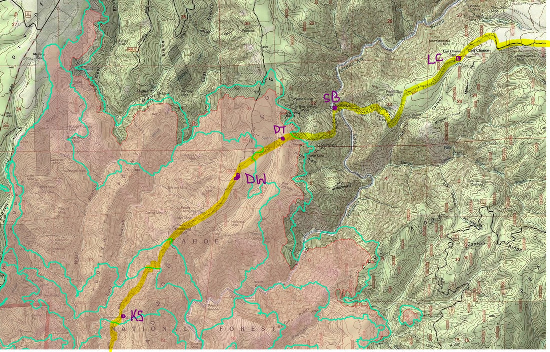 Example of the search function:  It is always difficult to find all the events at one park in one place, and our local State Parks, Auburn SRA and Folsom Lake SRA, weren't the exception. But now there is a good page that lists most all the events so you can plan your outing. There is a filter on the left so you can select your park and date range.
CLICK HERE to see the State Parks Events page. 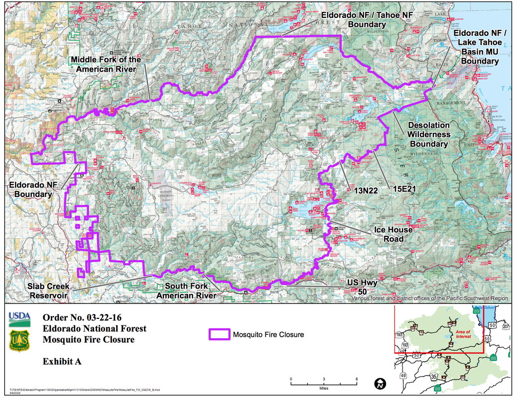 .Forest Order No. 03-22-16
Eldorado National Forest Pacific Southwest Region Mosquito Fire Area, Road, and Trail Closure Pursuant to 16 U.S.C. § 551 and 36 C.F.R. § 261.50(a) and (b), and to provide for public safety, the following acts are prohibited within the Eldorado National Forest. This Order is effective from September 9, at 12:00 pm, through December 31, 2022. 1. Going into or being upon National Forest System lands within the Mosquito Fire Closure Area, as described below and shown on Exhibit A. 36 C.F.R. § 261.52(e). The Mosquito Fire Closure Area boundary begins at the southwest corner of the Eldorado National Forest (ENF), Georgetown Ranger District, in Slab Creek Reservoir, and continues for approximately 3.8 miles through Slab Creek Reservoir, generally east to its head with the South Fork of the American River, then continues approximately 13.2 miles east along the South Fork American River to its intersection with US Highway 50, then continues approximately 0.1 miles generally southeast along US Highway 50 to its intersection with Ice House Road, then continues approximately 20.8 miles generally northeast along Ice House Road to its intersection with Forest Service (FS) Road 13N22 (Van Vleck Ranch Road), then continues approximately 5.4 miles generally northeast along FS Road 13N22 to its intersection with Forest Service Trail 15E21, then continues approximately 3.5 miles generally northeast along FS Trail 15E21 to its intersection with the Desolation Wilderness Boundary, then continues approximately 8.5 miles north and northeast along the Desolation Wilderness Boundary to its intersection with the ENF Boundary and Lake Tahoe Basin Management Unit (TMU) Boundary, then continues approximately 2.3 miles generally north along the ENF Boundary and TMU Boundary to its intersection with the ENF Boundary, TMU Boundary and Tahoe NF (TNF) Boundary, then continues approximately 22.2 miles generally west along the ENF Boundary and TNF Boundary, to its intersection with the Middle Fork of the American River, then continues approximately 34.5 miles generally southwest along the Middle Fork of the American River, to its intersection with the ENF Boundary near Cement Hill, then continues approximately 31.5 miles along the ENF Boundary generally south, to the starting point at its intersection with the ENF Georgetown Ranger District Boundary at Slab Creek Reservoir. 2.Being on any National Forest System Road within the Mosquito Fire Closure Area, as shown on Exhibit A. 36 C.F.R. § 261.54(e). 3. Being on any National Forest System trail within the Mosquito Fire Closure Area as shown on Exhibit A. 36 C.F.R. § 261.55(a). Pursuant to 36 C.F.R. § 261.50(e), the following persons are exempt from this Order: 1. Any Federal, State, or local officer, or member of an organized rescue or fire-fighting force in the performance of an official duty. 2. Persons with Forest Service Permit No. FS-7700-48 (Permit for Use of Roads, Trails, or Areas Restricted by Regulation or Order), specifically exempting them from this Order. 3. Owners or lessees of land and residents of such private landholdings, to the extent necessary to access their land. These prohibitions are in addition to the general prohibitions contained in 36 C.F.R. Part 261, Subpart A. A violation of these prohibitions is punishable by a fine of not more than $5,000 for an individual or $10,000 for an organization, or imprisonment for not more than 6 months, or both. 16 U.S.C. § 551 and 18 U.S.C. §§ 3559, 3571, and 3581. Executed in Placerville, California, this 9th day of September 2022, at 12:00 pm. JEFF MARSOLAIS Forest Supervisor Eldorado National Forest Pacific Southwest Region. To see the updated orders, visit Eldorado National Forest website HERE. To see the original document CLICK HERE https://www.fs.usda.gov/Internet/FSE_DOCUMENTS/fseprd1059205.pdf 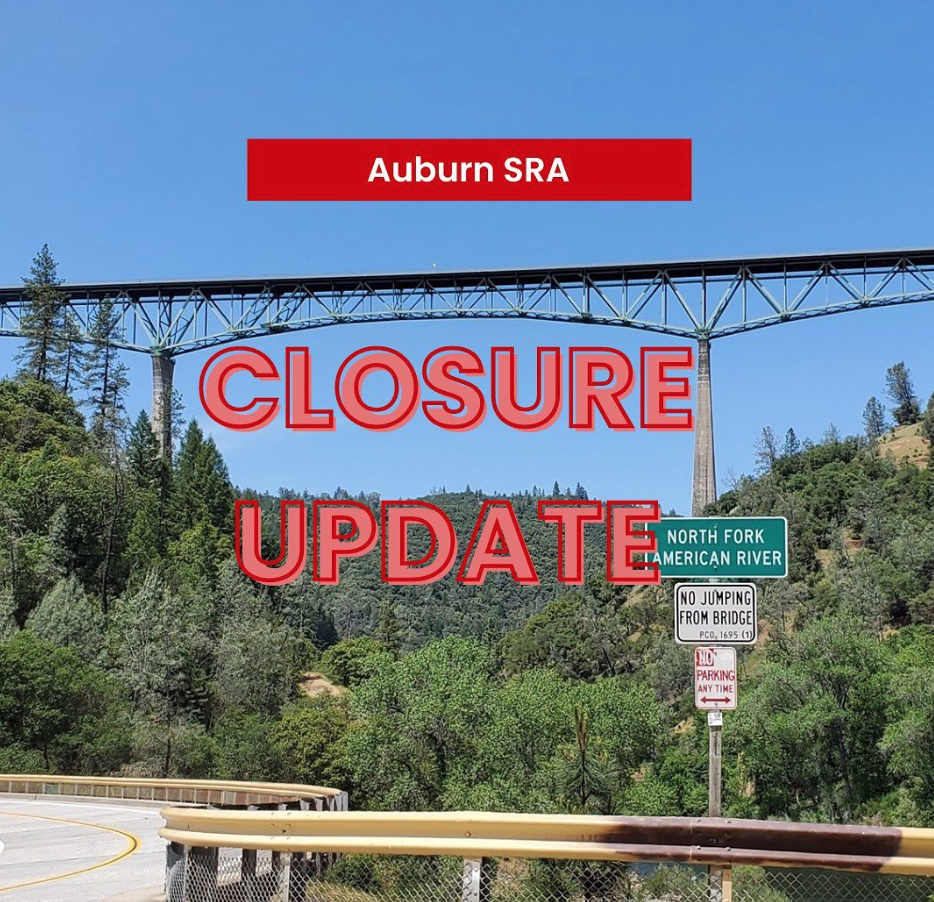 AUBURN SRA EXPANDS TEMPORARY CLOSURE TO ALL PARK UNITS DUE TO THE MOSQUITO FIRE
CLICK HERE FOR ORDER https://www.facebook.com/photo?fbid=412637927621127&set=a.268959168655671 "ALL Park Units in Auburn SRA will remained closed unit further notice. This closure includes, Lower Lake Clementine, Upper Lake Clementine, Mammoth Bar, Driver’s Flat (Ruck-A-Chucky), Yankee Jims, Ponderosa, Mineral Bar, Cherokee Bar, Quarry, Cool Staging, The Confluence, and China Bar. We are in a Mandatory Evacuation Zone: Foresthill Road will be closed at Lincoln & Foresthill, The Confluence will be closed at Old Foresthill and Hwy 49. Our hearts go out to our community, together we will get through this. Please remain vigilant, be prepared, and stay safe." --AUBURN STATE RECREATION AREA CLOSED: Auburn SRA, Folsom Lake SRA and major portions of TNF and trails affected by Mosquito Fire9/9/2022
 A large portion of the Tahoe National Forest will be closed to the public until at least Dec. 31, the U.S. Forest Service wrote on its website.
TRAIL CLOSURES Trails closed by the fire, according to previous Bee reporting, include the French Meadows Reservoir near the Middle Fork American River, the Western States Trail near Foresthill and the Pacific Crest Trail near Lake Tahoe. The Rubicon Trail in El Dorado County is also closed. Those who cross into the boundaries of the Mosquito Fire closure could land jail time or a fine of at least $5,000, the U.S. Forest service wrote on its website. STATE CLOSURES The entire Auburn State Recreation Area is closed “until further notice,” according to the state website. The park is south of Interstate 80, stretching from Auburn to Colfax along the American River. Friday morning air quality in Auburn reached hazardous levels, with an AQI of 420 due to particulate matter. Campers with reservations will be refunded. The Folsom Lake State Recreation Area also closed parts of its park due to the Mosquito Fire. The Peninsula Campground and day-use area is closed “until further notice.” Air quality near Folsom, as Friday morning, was unhealthy, according to Sacramento Region Spare the Air. Campers with reservation will be refunded. |
Archives
July 2024
Categories |
 RSS Feed