.Forest Order No. 03-22-16
Eldorado National Forest Pacific Southwest Region
Mosquito Fire Area, Road, and Trail Closure Pursuant to 16 U.S.C. § 551 and 36 C.F.R. § 261.50(a) and (b), and to provide for public safety, the following acts are prohibited within the Eldorado National Forest.
This Order is effective from September 9, at 12:00 pm, through December 31, 2022.
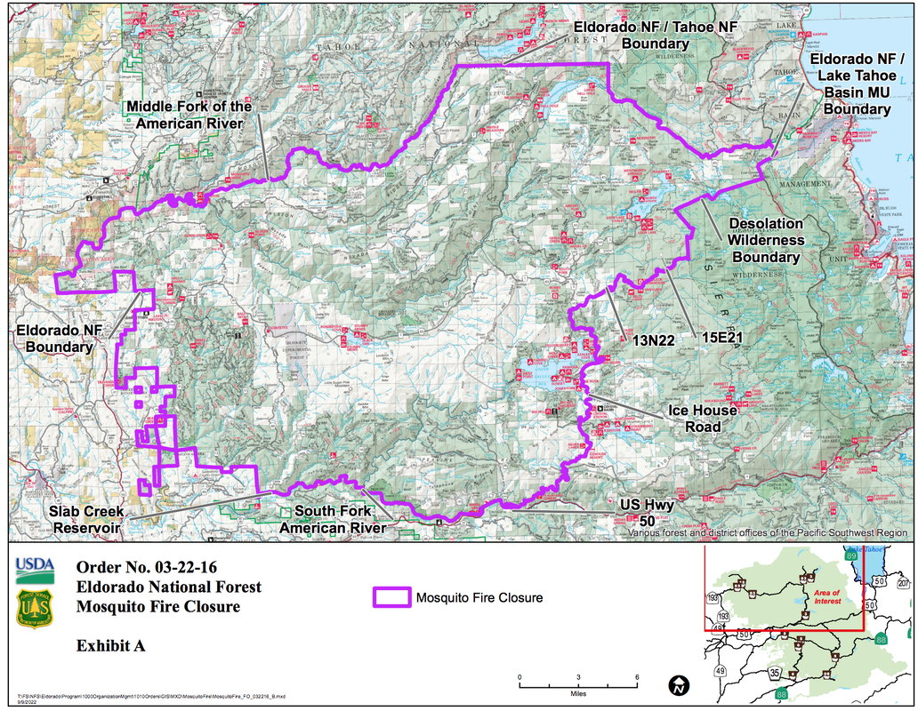
1. Going into or being upon National Forest System lands within the Mosquito Fire Closure Area, as described below and shown on Exhibit A. 36 C.F.R. § 261.52(e).
The Mosquito Fire Closure Area boundary begins at the southwest corner of the Eldorado National Forest (ENF), Georgetown Ranger District, in Slab Creek Reservoir, and continues for approximately 3.8 miles through Slab Creek Reservoir, generally east to its head with the South Fork of the American River, then continues approximately 13.2 miles east along the South Fork American River to its intersection with US Highway 50, then continues approximately 0.1 miles generally southeast along US Highway 50 to its intersection with Ice House Road, then continues approximately 20.8 miles generally northeast along Ice House Road to its intersection with Forest Service (FS) Road 13N22 (Van Vleck Ranch Road), then continues approximately 5.4 miles generally northeast along FS Road 13N22 to its intersection with Forest Service Trail 15E21, then continues approximately 3.5 miles generally northeast along FS Trail 15E21 to its intersection with the Desolation Wilderness Boundary, then continues approximately 8.5 miles north and northeast along the Desolation Wilderness Boundary to its intersection with the ENF Boundary and Lake Tahoe Basin Management Unit (TMU) Boundary, then continues approximately 2.3 miles generally north along the ENF Boundary and TMU Boundary to its intersection with the ENF Boundary, TMU Boundary and Tahoe NF (TNF) Boundary, then continues approximately 22.2 miles generally west along the ENF Boundary and TNF Boundary, to its intersection with the Middle Fork of the American River, then continues approximately 34.5 miles generally southwest along the Middle Fork of the American River, to its intersection with the ENF Boundary near Cement Hill, then continues approximately 31.5 miles along the ENF Boundary generally south, to the starting point at its intersection with the ENF Georgetown Ranger District Boundary at Slab Creek Reservoir.
2.Being on any National Forest System Road within the Mosquito Fire Closure Area, as shown on Exhibit A. 36 C.F.R. § 261.54(e).
3. Being on any National Forest System trail within the Mosquito Fire Closure Area as shown on Exhibit A. 36 C.F.R. § 261.55(a). Pursuant to 36 C.F.R. § 261.50(e), the following persons are exempt from this Order:
1. Any Federal, State, or local officer, or member of an organized rescue or fire-fighting force in the performance of an official duty.
2. Persons with Forest Service Permit No. FS-7700-48 (Permit for Use of Roads, Trails, or Areas Restricted by Regulation or Order), specifically exempting them from this Order.
3. Owners or lessees of land and residents of such private landholdings, to the extent necessary to access their land. These prohibitions are in addition to the general prohibitions contained in 36 C.F.R. Part 261, Subpart A.
A violation of these prohibitions is punishable by a fine of not more than $5,000 for an individual or $10,000 for an organization, or imprisonment for not more than 6 months, or both. 16 U.S.C. § 551 and 18 U.S.C. §§ 3559, 3571, and 3581. Executed in Placerville, California, this 9th day of September 2022, at 12:00 pm. JEFF MARSOLAIS Forest Supervisor Eldorado National Forest Pacific Southwest Region.
To see the updated orders, visit Eldorado National Forest website HERE.
To see the original document CLICK HERE
https://www.fs.usda.gov/Internet/FSE_DOCUMENTS/fseprd1059205.pdf
Eldorado National Forest Pacific Southwest Region
Mosquito Fire Area, Road, and Trail Closure Pursuant to 16 U.S.C. § 551 and 36 C.F.R. § 261.50(a) and (b), and to provide for public safety, the following acts are prohibited within the Eldorado National Forest.
This Order is effective from September 9, at 12:00 pm, through December 31, 2022.
1. Going into or being upon National Forest System lands within the Mosquito Fire Closure Area, as described below and shown on Exhibit A. 36 C.F.R. § 261.52(e).
The Mosquito Fire Closure Area boundary begins at the southwest corner of the Eldorado National Forest (ENF), Georgetown Ranger District, in Slab Creek Reservoir, and continues for approximately 3.8 miles through Slab Creek Reservoir, generally east to its head with the South Fork of the American River, then continues approximately 13.2 miles east along the South Fork American River to its intersection with US Highway 50, then continues approximately 0.1 miles generally southeast along US Highway 50 to its intersection with Ice House Road, then continues approximately 20.8 miles generally northeast along Ice House Road to its intersection with Forest Service (FS) Road 13N22 (Van Vleck Ranch Road), then continues approximately 5.4 miles generally northeast along FS Road 13N22 to its intersection with Forest Service Trail 15E21, then continues approximately 3.5 miles generally northeast along FS Trail 15E21 to its intersection with the Desolation Wilderness Boundary, then continues approximately 8.5 miles north and northeast along the Desolation Wilderness Boundary to its intersection with the ENF Boundary and Lake Tahoe Basin Management Unit (TMU) Boundary, then continues approximately 2.3 miles generally north along the ENF Boundary and TMU Boundary to its intersection with the ENF Boundary, TMU Boundary and Tahoe NF (TNF) Boundary, then continues approximately 22.2 miles generally west along the ENF Boundary and TNF Boundary, to its intersection with the Middle Fork of the American River, then continues approximately 34.5 miles generally southwest along the Middle Fork of the American River, to its intersection with the ENF Boundary near Cement Hill, then continues approximately 31.5 miles along the ENF Boundary generally south, to the starting point at its intersection with the ENF Georgetown Ranger District Boundary at Slab Creek Reservoir.
2.Being on any National Forest System Road within the Mosquito Fire Closure Area, as shown on Exhibit A. 36 C.F.R. § 261.54(e).
3. Being on any National Forest System trail within the Mosquito Fire Closure Area as shown on Exhibit A. 36 C.F.R. § 261.55(a). Pursuant to 36 C.F.R. § 261.50(e), the following persons are exempt from this Order:
1. Any Federal, State, or local officer, or member of an organized rescue or fire-fighting force in the performance of an official duty.
2. Persons with Forest Service Permit No. FS-7700-48 (Permit for Use of Roads, Trails, or Areas Restricted by Regulation or Order), specifically exempting them from this Order.
3. Owners or lessees of land and residents of such private landholdings, to the extent necessary to access their land. These prohibitions are in addition to the general prohibitions contained in 36 C.F.R. Part 261, Subpart A.
A violation of these prohibitions is punishable by a fine of not more than $5,000 for an individual or $10,000 for an organization, or imprisonment for not more than 6 months, or both. 16 U.S.C. § 551 and 18 U.S.C. §§ 3559, 3571, and 3581. Executed in Placerville, California, this 9th day of September 2022, at 12:00 pm. JEFF MARSOLAIS Forest Supervisor Eldorado National Forest Pacific Southwest Region.
To see the updated orders, visit Eldorado National Forest website HERE.
To see the original document CLICK HERE
https://www.fs.usda.gov/Internet/FSE_DOCUMENTS/fseprd1059205.pdf
 RSS Feed