MOTHER LODE TRAILS
  • Home
  • About
  • Contact
  • Volunteer
  • Links
    • Law Enforcement Emergency
    • Federal, State, County Districts Parks & Trails
    • Running Clubs
    • Equestrian Clubs
    • Mt. Bike Clubs
    • Hiking Clubs
    • Trail Advocacy Organizations
    • Phone Numbers State & Federal Parks, Trails & Lands
    • Where to Eat on the Trails
  • News
  • Alerts

Day hiker: Waddle Ranch Preserve takes hikers to a higher place

5/31/2024

 
Picture
Waddle Ranch Preserve is accessed via Martis Dam Road off Highway 267 by the airport in Martis Valley near Truckee.

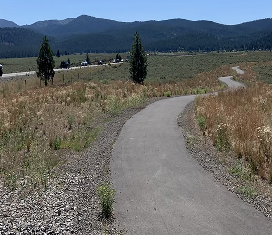
Eight miles of trail await you in a maze that wanders through the forest and offers beautiful views of the snow-capped Sierra Nevada Mountains and meadow below.

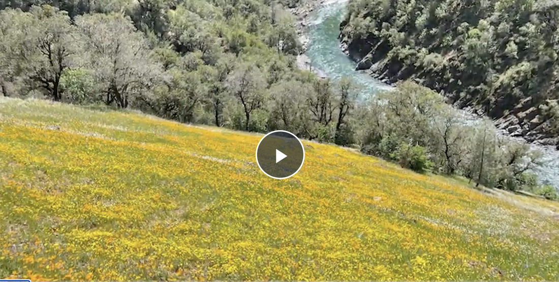
The flowers in late July were spectacular. To hear water running, bees buzzing and the breeze through the trees is always a great change of pace from the lower elevations. A refuge for many species fleeing development in the thriving town of Truckee, the preserve is 1,462 acres of trust land that can never be developed while assuring public access. Thank you to the Truckee Donner Land Trust and the Trust for Public Lands.

Two sets of two cyclists were all I shared the trails with on my hike. Ella Lake was a high point. The marshy soil around the lake was alive with little amphibians I took for frogs, but I'm not an expert. Seep gardens in the meadows were a living bouquet of wildflowers. The variety, some I had only seen pictures of like Ranger’s buttons, were a joy to discover. East Martis Creek runs through the preserve. A beaver had built quite a dam near the meadow.

There is a crispness and lightness to the Sierra Nevada Mountain air I have not found equaled anywhere.

I’m grateful for so many trail options. In the immediate vicinity of the Waddle Ranch Preserve is also Martis Creek Wildlife Area, Glacier Way Trailhead and the Alpine Meadow campground.
​

Dogs are welcome on leash. No fees collected at the trailhead where I parked outside the Soaring Association at Sailplane Way.
​

Mary West is author of the book series Day Hiker - Gold Country Trail Guide I, II, III and now IV. All are available on Amazon. The books are a collection of the Day Hiker columns where West shares her longtime love of the outdoors, favorite hikes in Northern California’s Gold Country and beyond. West was the recipient of the 2017 and 2019 CRAFT Award for Best Outdoor Column and the 2020 Craft Award for her second book in the series - Day Hiker Gold Country.

CLICK HERE to see the complete article and more photos in the Gold Country Media page.


Picture

Tahoe National Forest announces 2024 summer interpretive programs

5/27/2024

 
Picture
Beginning May 24, 2024, visitors to the Tahoe National Forest will have the opportunity to enjoy a variety of free interpretive walks, guided hikes and campground programs at locations across the forest.  
  • Campground programs are designed for visitors of all ages and abilities who come eager to learn and excited to experience their public lands.  
  • Pop-up tables will be stationed across the forest with general information and friendly staff available to answer questions. 
  • Discovery hikes* are excursions for visitors interested in exploring areas of the forest they may not explore otherwise. These hikes are generally less than five miles, with some steep and uneven terrain.  
  • Interpretive walks* are intended for all ages, though participants should be able to walk up to two miles on mostly flat, uneven terrain.

*Hikers should come prepared with sturdy boots, a snack, water and sun protection.  
Interpretive programs are an excellent way for visitors of all ages to learn about the local area while forming lasting memories and connections. These programs and activities support the U.S. Forest Service’s mission by providing recreation opportunities that will help facilitate understanding and appreciation for natural resources while fostering responsible land stewardship. 

Tahoe National Forest’s interpretive programs have a wide variety of topics, including Leave No Trace, astronomy, fire safety, wildlife, cultural and natural history. Visitors are encouraged to plan ahead by visiting fs.usda.gov/goto/TahoeOnTour2024 for more program information and a schedule of events. All programs are subject to change due to inclement weather and staff availability.  

Please contact the Tahoe National Forest Supervisor’s Office at (530) 265-4531 or the American River Ranger District at (530) 492-5631 with any questions. 

To see the complete article and more photos, visit YubaNet.net:
https://yubanet.com/regional/tahoe-national-forest-announces-2024-summer-interpretive-programs/

eBikes: increase in traumatic brain injuries require better helmets

5/26/2024

 
Picture
FROM CONSUMER REPORTS:
Wearing a 
helmet is important any time you get on any type of bike. Yet many electric bikes can reach speeds that casual riders won’t on a conventional bike.  “If I were riding [an e-bike], I would want more protection” than many typical bike helmets offer, says Randy Swart, executive director of the nonprofit Bicycle Helmet Safety Institute and former vice chair of the helmet and headgear subcommittee for ASTM International, a nonprofit, voluntary standards-setting organization.


THE ROLE OF SPEED
Electric bike riders tend to average higher speeds than conventional cyclists, according to a white paper reviewing research on the topic (PDF) prepared for People for Bikes, a bicycling advocacy organization. The maximum speed of an electric bike can be 20 or even 28 miles per hour, depending on its type—and there are bikes sometimes sold as e-bikes that go even faster. R
esearch indicates that traumatic brain injury rates are similar for electric bike riders and conventional cyclists, though higher velocity at the time of an accident is associated with an increased risk for a traumatic brain injury or a concussion.

Helmets That Meet the Dutch Electric Bike Standard
Riders could also look for helmets certified to meet a Dutch standard created specifically for e-bikes, NTA 8776. This standard requires helmets to have more protection on the sides and back of the head, like that found on many skate- and urban commuter-style helmets. Some of the helmets in that style in CR’s ratings are certified to meet the NTA 8776 standard.

To read the original article in Consumer Reports, CLICK HERE.


Incredible new trail to the North Fork will open to public after conservation pact

5/25/2024

 
Picture
Just outside the Placer County community of Auburn, one of the largest concentrations of private land along the North Fork American River was recently purchased for conservation, a deal that will soon open a new hiking trail to one of Northern California’s most popular summertime river destinations.

This spring, the San Francisco-based Trust for Public Land and Placer Land Trust closed a $6.4 million deal to acquire 1,567 acres skirting the river’s western edge between Interstate 80 and the sprawling Auburn State Recreation Area. The property is consolidated in four large, undeveloped blocks of pine- and oak-studded hillsides covering 6 miles of river frontage, including along the banks of sparkling Lake Clementine. Though undeveloped, it had effectively walled off public access to a gorgeous area in the remote river canyon that is suitable for sunbathing and swimming.

The property’s longtime owners at one point had proposed building 97 homes there, but five years ago agreed instead to sell it to the Placer Land Trust. By adding to the tens of thousands of acres of contiguous protected open space east of Auburn, the deal is a win for conservationists who’d been eyeing the woodland parcels for two decades.

“This is a huge deal,” said Jeff Darlington, Placer Land Trust executive director. “Instead of being locked off by development, now we’ve got an area just a few minutes off the highway where you can access the river — finally.”

The North Fork American runs nearly parallel to I-80 through Auburn, but it’s tough to access for the nearly 1 million annual visitors to the Auburn State Recreation Area who come to boat, fish, paddle and camp. Its closest access points are on the east side of Lake Clementine and at the confluence of the north and middle forks of the American River — areas that become choked with traffic during the hot summer months.
​

The newly purchased land includes a trailhead just off I-80 in the Placer County town of Applegate with a dirt parking area where hikers and horseback riders can travel a 2-mile path to a secluded beach on the river’s western bank.
“I’m excited to have another access point that’ll hopefully ease the congestion at the lake and the confluence,” said Kate Nitta, a stand-up paddleboarder who lives in Sacramento and sits on the board of the Placer Land Trust. “We always need more recreational space here. Let’s not turn it all into houses.”
The property was long owned by Sacramento’s Tsakopoulos real estate development family, whose company is one of the state’s largest landowners, according to the Trust for Public Land. 

Placer Land Trust had been working to buy the land for the past 20 years and was able to cobble together the purchase price with help from the Trust for Public Land as well as a grant from the federal Land and Water Conservation Fund program. The land was transferred to the Bureau of Land Management this month.
​

In a statement, former landowner Angelo Tsakopoulos said his family is “very happy with this conservation outcome.” “This land, the river and the lake are special, and we’ve enjoyed seeing wildlife thrive here,” he said. “We’re pleased to know this land and the trail on it will be open to public access and recreation under BLM ownership.”

On a recent visit to the trailhead parking area, a billboard-size “Private Property” sign staked into the dirt and pocked with bird shot warned visitors away. Unfazed, a dirt bike and all-terrain vehicle roared down the trail a stone’s throw from the lot.

How exactly the area could be upgraded or improved isn’t yet clear. However, “the land acquisition is intended to provide new trails and access to the river,” according to Philip Oviatt, public affairs officer for the Bureau of Land Management’s Central California District.

The property’s 5 miles of trails are likely to be open to hikers, mountain bikers and horseback riders, but probably not dirt bikers and off-roaders, Darlington said. He’d like to see the ominous Private Property sign replaced by an interpretive kiosk and maybe a restroom at the trailhead — something more welcoming for river-goers eager to explore a new corner of the Sierra foothills.
“Instead of 97 homeowners being able to enjoy it, now everyone can,” he said.

Read original article and see more photos in the San Francisco Chronicle newspaper HERE.


Article by Gregory Thomas: [email protected]

Final draft of Nevada County Recreation and Resiliency Plan

5/23/2024

 
Picture
The Community Development Agency is leading the development of the first-ever Recreation and Resiliency Master Plan to identify recreation needs and articulate a long-term vision for managing open spaces and recreation resources that range from local parks, playgrounds, sports fields, and facilities to rivers, trails, and outdoor access. Additionally, the plan will address environmental and human-related impacts including, but not limited to, wildfires, natural disasters, drought, a changing climate, and increased visitation.

The planning process will engage diverse partners, including, but not limited to, public lands managers, nonprofit stakeholders, and user groups, to plan, fund, and implement sustainable solutions. The plan will include clear identification of viable, prioritized recreation enhancement and development projects, and related funding strategies, in unincorporated Nevada County and that involve Nevada County government. 

This project is made possible, in part, through funding by the Sierra Nevada Conservancy Vibrant Recreation and Tourism grant program.

We are now in Phase 4

Phase 4: Final Plan Document and Plan Adoption
  • The FINAL DRAFT plan is available below:
    • Chapter 0-3, with Executive Summary
    • Chapter 4-6 State of the System
    • Chapter 7 Focus Area Recommendations
    • Chapter 8 Action Plan
  • Board meeting presentation May 28, 2024. Please see the agenda for the presentation time, which will be published on May 23, 2024.
    • The Board will receive the presentation, review the final draft plan, and provide direction on the staff's request for approval. 

Recreation and Resiliency Master Plan
Project Contact: Senior Administrative Analyst,
Erika Seward
530-265-1572
[email protected]

TO SEE THE COMPLETE PLAN WEBPAGES:
https://www.nevadacountyca.gov/3641/Recreation-and-Resiliency-Master-Plan

New HQ Building Approved For Tahoe Natl Forest

5/17/2024

 
May. 17, 2024 - After around a decade of efforts, the Tahoe National Forest is finally getting a new headquarters building to replace its smaller and aging facility. Nevada County Supervisors have approved a resolution accepting and executing a 50-year lease agreement worth $2.6 million dollars for the county on a nine-acre parcel adjacent to the Juvenile Hall property. It’ll be located off Highway 49, and still near Nevada City and also across the road from the Rood Center. Acting Tahoe National Forest Supervisor Matt Jedra told the Board that they’ll have one lease to deal with, compared to the current situation.

Matt Jedra 
also noted that the construction cost has nearly doubled since pre-COVID, to around $25 million dollars and they’re pursuing federal funding. Supervisor Hardy Bullock also likes the potential for good accessibility.

If all goes well, it’s hoped the 23,000 square-foot facility will open sometime in 2027.

To listen to the complete show, click here.


Hike the Windy Trail in Placer County, a challenging but gorgeous journey

5/17/2024

 
Picture
Windy Point Trail offers stunning views of the American River
The North Fork of the American River winds through a steep forest and cliff-lined canyon in Placer County.Access to the remote area can be difficult, but where available, visitors are rewarded with grand views of the steep canyon scenery.
The Windy Point Trail is one of those areas where hikers can traverse the canyon wall, descending through trees, grass and wildflowers. The trail starts a mile past the Mineral Bar Campground near a small parking area along Iowa Hill Road, south of Colfax, in a shaded oak woodland for about a quarter-mile before traversing onto the steep canyon wall above the American River. At this point, you are awarded with your first view of the immense canyon and it only gets better from here.
The trail, first constructed by prospectors looking for riches during the California gold rush, makes you descend into the canyon over rock outcroppings.
Hikers should wear boots, if available, and bring walking poles to stabilize on the loose shale that is scattered about the trail.
While the middle of May proved to be too late for many of the wildflowers, there were still enough blooms to provide color among the dry landscape. As you descend the trail, look over your shoulder at the Transcontinental Railroad. From here, you get a rare glimpse at the Cape Horn pass. It's a short section of railroad that took hundreds of Chinese laborers a year to blast and dig into the cliff face.
The Windy Point Trail is 1.5 miles one way into the canyon. Hikers beware, what goes down has to hike back up. It's an arduous but enjoyable return hike out of the canyon with a whole new set of views looking up the river.
Keep your ears open and you may occasionally hear the whoops and hollers of rafters braving the rapids below.
For more information on the Windy Point Trail and access to the trailhead, follow this link the Auburn State Recreation Area Canyon Keepers page.

To see the complete article and video, visit the KCRA web page.


​


Nearly 2.7 million  in tourism-generated funding approved for four projects in North Lake Tahoe

5/8/2024

 
Picture
The Placer County board approved a total of $2,680,000 in TOT funds for the following projects over the next year:
  • $250,000 in TOT funding for the North Tahoe Recreation Access Plan Project led by Placer County in partnership with the U.S. Forest Service
  • $2 million to construct Martis Valley Trail Segment 3F via the Northstar Community Services District
  • $400,000 to construct Phase 2 of the Tahoe Cross Country Lodge project overseen by the Tahoe Cross Country Ski Education Association
  • $30,000 to construct North Tahoe Mountain Biking Trails / FS 73 Bypass via the Tahoe Area Mountain Biking Association in partnership with U.S. Forest Service
Four investment projects in eastern Placer County amounting to nearly 2.7 million were approved Tuesday by the Placer County Board of Supervisors to advance regional goals including improved transportation and recreation.
Revenue from Tahoe’s Transient Occupancy Tax is being used to fund the projects, which were solicited, vetted and recommended through the North Tahoe Community Alliance Board of Directors, the TOT committee and the Capital Projects Advisory committee and moved forward via the TOT-TBID Dollars at Work annual grant cycle.
“It’s partnerships, like this one with the U.S. Forest Service and Northstar, that really ensure we’re getting the most out of our TOT contributions,” said District 5 Supervisor Cindy Gustafson. “These projects are an important addition to our community to ensure additional recreation opportunities and more importantly, alternative transportation options for residents and visitors alike.”
In 2021, the North Tahoe Recreation Access Plan identified over 20 existing access locations to public lands that need improvements to recreational trails, trailheads and related facilities. Today’s approved contract will allocate $250,000 to improve the existing infrastructure at the site located off Thelin Drive in Truckee.
Two million dollars of TOT funding will go to the Martis Valley Tail, which is a 10-mile paved class 1 multiple-use trail through Martis Valley and the Northstar California resort that climbs to the ridgeline of the Lake Tahoe Basin. This agreement will fund the construction of Segment 3F, which will complete the trail from Northstar Castle Peak parking lots to The Village at Northstar.
The board also approved $400,000 to fund the Tahoe Cross Country Lodge project. This includes project management, contracting and consulting for the relocation and adaptive reuse of a historic 1930’s home as Tahoe Cross Country’s new, year-round outdoor recreation trailhead and community gathering place.
Finally, the board approved $30,000 to construct one mile of a singletrack trail to connect the bottom of the Antone Meadows area to the Whoop-de-doo Trail and the Tahoe Rim Trail Painted Rock section. This trail connection is three miles northwest of Tahoe City and the project is in partnership with the U.S. Forest Service.
Earlier in April, the NTCA Board of Directors voted to approve nine Tourism Business Improvement District projects for $1,638,669. Read more about those projects hereNearly 2.7 million  in tourism-generated funding approved for four projects in North Lake Tahoe.
Learn more about TOT funding and projects in North Lake Tahoe by clicking here. Visit  TOT-TBID Dollars At Work for more information..

​https://www.placer.ca.gov/9727/Four-Tahoe-projects-receive-funding

Day Hiker: Mammoth Bar - hike when there are no dirt bikes

5/2/2024

 
Picture
by Mary West
No dirt bikes at Murderer's Bar rapids
I found Mammoth Bar when I worked for California State Parks in the Auburn State Recreation Area.
Most know this as the OHV Park with noisy and smelly motorcycles. But have you ever been on a day that wasn’t open to dirt bikes? It happens every week. No one around except the insiders that know what is down there.

It is currently open only for 3 days a week to motorcycles (Sun., Mon., Thurs.) during the summer (April-Sept.) so that leaves four noise-free days a week for the foot crew.


For one, easy access to the river. Improvements have been made with a larger, paved parking area, more toilets and trash cans. A fee is still collected but your Poppy Pass works here. Drive to the back of the parking lot to park, then watch your step over the river rocks and take in the view of the North Fork of the American River rushing by.

If you find this area already taken, head back out past the kiosk. The first signed parking area on the left offers a short scramble down to the river next to the Murderer's Bar rapids. Several semi-isolated sand and river-rock beaches are here. I used to take my sons here to swim with the otters. Little fish looking for a snack would brush against our toes where we disturbed the sand.

The access to Murderer’s Bar rapids is not an easy stroll. Lots of rocks, roots and ruts are hurdles on this narrow path through brush and oak woodland. Once in the direct sun in summer, the heat will zap your energy. Take lots of water and protect yourself with sunblock, a hat and sunglasses.

If you intend to swim with the fish, know there are many hazards under the surface, not to mention the current can be fast and incredibly cold even into summer. The rapids are their own hazard. I stay upriver of the rapids when I visit.
​

Mary West is author of the book series Day Hiker – Gold Country Trail Guides I, II, III and now IV, all available on Amazon. The books are a collection of the Day Hiker columns where West shares her longtime love of the outdoors, favorite hikes in Northern California’s Gold Country and beyond. West was the recipient of the 2017 and 2019 CRAFT Award for Best Outdoor Column and the 2020 Craft Award for her second book in the series – Day Hiker Gold Country.

    Archives

    June 2025
    May 2025
    April 2025
    March 2025
    February 2025
    January 2025
    December 2024
    November 2024
    October 2024
    September 2024
    August 2024
    July 2024
    June 2024
    May 2024
    April 2024
    March 2024
    February 2024
    January 2024
    December 2023
    November 2023
    October 2023
    September 2023
    August 2023
    July 2023
    June 2023
    May 2023
    April 2023
    March 2023
    February 2023
    January 2023
    December 2022
    November 2022
    October 2022
    September 2022
    August 2022
    July 2022
    June 2022
    May 2022
    April 2022
    March 2022
    February 2022
    January 2022
    December 2021
    November 2021
    October 2021
    September 2021
    August 2021
    July 2021
    June 2021
    May 2021
    April 2021
    March 2021
    February 2021
    January 2021
    December 2020
    November 2020
    October 2020
    September 2020
    August 2020
    July 2020
    June 2020
    May 2020
    April 2020
    March 2020
    February 2020
    January 2020
    December 2019
    November 2019
    October 2019
    September 2019
    August 2019
    July 2019
    June 2019
    May 2019
    April 2019
    March 2019
    February 2019
    January 2019
    December 2018
    November 2018
    October 2018
    September 2018
    August 2018
    July 2018
    June 2018
    May 2018
    April 2018
    March 2018
    February 2018
    January 2018
    December 2017
    November 2017
    October 2017
    September 2017
    August 2017
    July 2017
    June 2017
    May 2017
    April 2017
    March 2017
    February 2017
    January 2017
    December 2016
    November 2016
    October 2016
    September 2016
    August 2016
    July 2016
    June 2016
    May 2016
    April 2016
    March 2016
    February 2016
    January 2016
    December 2015
    November 2015
    October 2015
    September 2015
    August 2015
    July 2015

    Categories

    All

    RSS Feed

Home
Contact
 Mother Lode Trails is YOUR local volunteer-run trail information and resource website. Here you can find
up-to-the minute information on trail alerts, links and trail news for Placer,  Yuba, and Nevada counties.
Mother Lode Trails is trademarked.