MOTHER LODE TRAILS
  • Home
  • About
  • Contact
  • Volunteer
  • Links
    • Law Enforcement Emergency
    • Federal, State, County Districts Parks & Trails
    • Running Clubs
    • Equestrian Clubs
    • Mt. Bike Clubs
    • Hiking Clubs
    • Trail Advocacy Organizations
    • Phone Numbers State & Federal Parks, Trails & Lands
    • Where to Eat on the Trails
  • News
  • Alerts

Another atmospheric river hitting this week - stay off the trails

3/26/2023

 
Picture
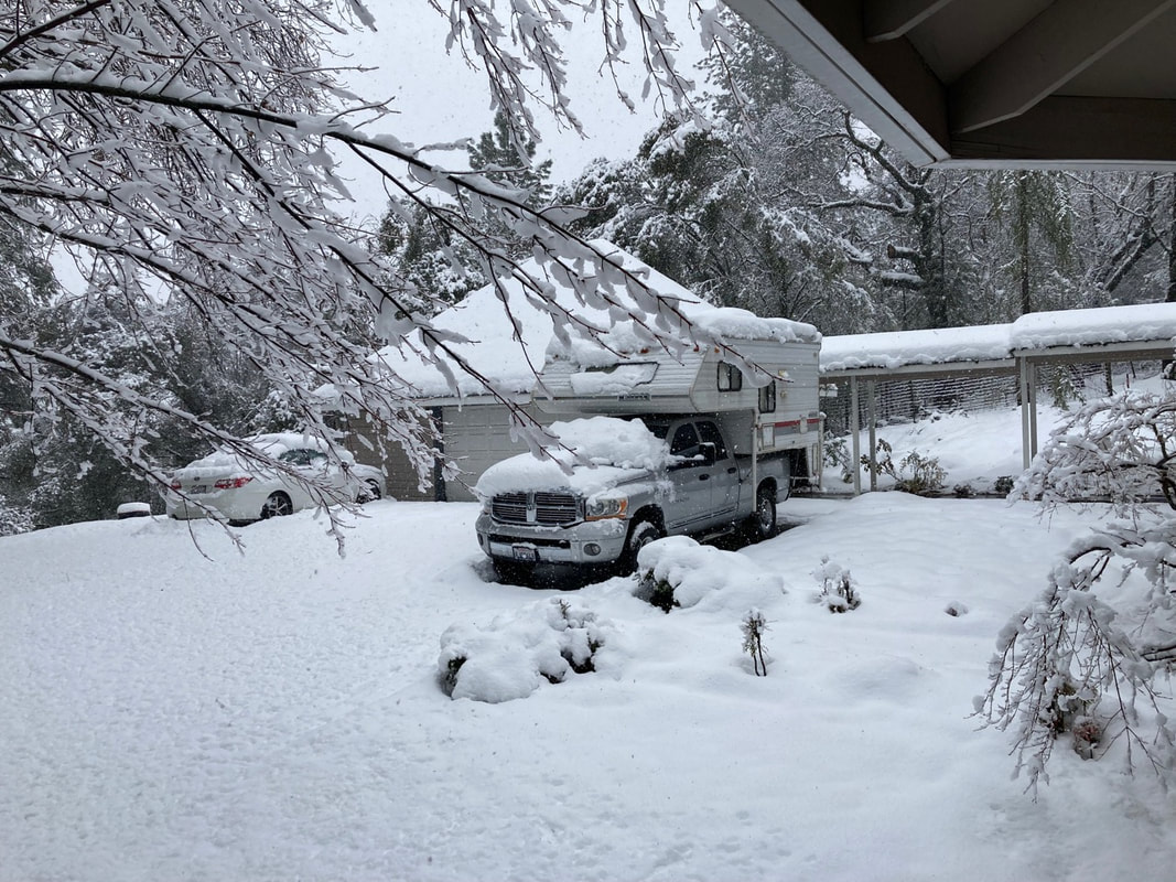
The weather service has alerted us to another big storm coming in on Tuesday. Lake Tahoe trails will see another 3 feet of snow and the lower elevations will have several more inches of rain. With this latest storm, we are expected to register the snowiest and wettest winter since weather data has been collected.

What does this mean for our trails?
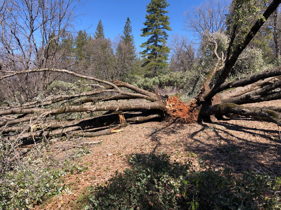
Muddy trails are vulnerable trails. Every trails organization, whether it be IMBA, the main organization for mt. bikes, or BCHC and CSHA for horse folks, have strict rules against riding on wet trails. Why? Because hooves and tires cause erosion…both of different sorts. Tires create ruts, where subsequent rains and water channel and rut deeper. Hooves on hard trails create circles of mud, actually helping deter run off, BUT if horses go off the trail, even a few inches, deep holes are made. If horses head straight downhill on a steep trail, the slide marks will create ruts and encourage erosion. Both modes of transportation destroy delicate trails.

From IMBA's rules for mt. bikes:
"Be sensitive to the dirt beneath you. Wet and muddy trails are more vulnerable to damage than dry ones. When the trail is soft, consider other riding options. This also means staying on existing trails and not creating new ones.."

From BCH and California State Horsemen:
Avoid sensitive areas and wet or muddy trails. Leave no Trace. Practice Gentle Use Principles. Be sensitive to the earth beneath you. Recognize different types of soils and trail conditions. Wet and muddy trails are more vulnerable to damage, so consider other options. Please stay on existing trails; do not create new ones and do not shortcut."

So, where do you ride?
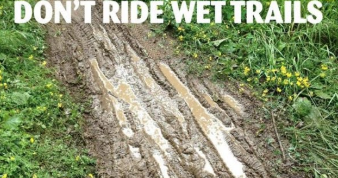
First, wait. Normally, we can wait 24 - 48 hours after the last rain for most trails to adequately dry out. But after the soil is soaked by repeated heavy rainfall, it may be over a week. If there are puddles in the middle of the trail, DO NOT RIDE AROUND THEM. Your horse or bike will widen the trail - soon, instead of a 5 feet wide trail, you have a 15 feet wide trail of ruts. (see photo)

Where is the best place to ride after I wait?
The sandier, the better. Sandy soil drains much faster than clay soil. In our area, for example, the trails around Folsom Lake SRA have a natural base of decomposed granite and are good to go after the wait. Or, stay on the gravel ranch roads at Hidden Falls Regional Park or Empire Mine.
​

Toughest Endurance Race on Earth (full documentary) Tevis Cup

3/25/2023

 
Picture
This Tevis Cup documentary finally available in English and posted on YouTube here.
https://www.youtube.com/watch?v=loAxq3qTBWk


Riding With Horses Production: Follow along this journey of 187 horses and their riders as they aim to be one of the 50% that are able to complete the most grueling and challenging 1-day endurance race on the planet: The Western States Trail Ride.

​

Gold Country Equestrian Trail Head at Lone Grave still snowed in

3/25/2023

 
Picture
Report from Saturday morning, March 25. The trailhead parking area still under snow. Will be a bit longer before it can be used.

UPDATE on downed trees on Empire Mine trails

3/25/2023

 
From reports today all the trees have been cleared on main and spur trails at Empire Mine. No reports on the Union Hill side yet.
Picture
Received this from a Gold Country Trails Council member:
"​Today I rode at Empire Mine and it was destroyed with downed trees. The fire road was semi clear with one tree down, but all the loops had down trees. The main HardRock trail was clear to a point. There were so many, I can't report them all. The other side of Highway 174 was a little better."
Picture

Spenceville Wildlife Area closed for annual turkey hunt March 25-April 2

3/24/2023

 
Picture
Every year, the Spenceville Wildlife Area is closed for the official CA Fish and Game turkey hunt. It will be closed from March 25, the opening day of turkey season, to April 2 this year.

This means no hiking, no horse back riding, nothing but hunting to licensed hunters who have won the lottery picks.

(photo by Suzanne Vacarro, Gold Country Trails Council)

Placer County wildflowers starting to bloom

3/23/2023

 
Picture
Spring Equinox has arrived! 
As we draw closer to Placer County's poppy and lupine super bloom, remember to:
1. STAY ON THE TRAIL! (Protect the native ecosystem and make sure seeds are there for the next year).
2. Pack in, Pack out (Be responsible with all your trash).
3. Stop by a California Welcome Center for Outdoor Recreation maps & info, or download GPX files from Gold Country Trails Council. 
4. Some of the best hikes are described here on Mother Lode Trails. Be sure to check them out under the NEWS tab.

.

Internet restored for Mother Lode Trails

3/17/2023

 
Picture
UPDATE:
We are back online! The fiber is working perfectly and now we'll be catching up. Thank you, Race Communications!

----------------------
The photo is from February 28, the day the Internet died. We aren't going camping anytime soon. Normally at this elevation we get no more than a few inches of snow which melts off in a day or two. This year and last January were dramatically different. We call them the Donner Party years.

We have been really spoiled by the Race Communications fiber gigabit network over the past two years and became dependent on it for phone, streaming, Internet, etc.

We will keep you trail users updated as soon as we have our Internet back!


El Dorado CO Parks and Trails Plan meetings coming up March and April

3/15/2023

 
Picture
Be sure to read the Mission Statement below and see if it agrees with your goals for their Parks and Trails Plan.

​Meeting dates and times:
  • The 2nd Parks and Trails Master Plan Workshop is March 22, 2023 from 
    6 PM - 7 PM at Pioneer Park Community Center.


    Address: 6740 Fair Play Road, Somerset, CA 95684
    Registration is not required to attend.

  • The 3rd Parks and Trails Master Plan Workshop is March 29, 2023 from 
    6 PM - 7 PM at Buckeye Elementary School.


    Address: 4561 Buckeye Road, Shingle Springs, CA 95682
    Registration is not required to attend.


  • The 4th Parks and Trails Master Plan Workshop is April 5, 2023 from
    6 PM - 7 PM at Pollock Pines Community Center.


    Address: 2675 Sanders Drive, Pollock Pines, CA 95726
    Registration is not required to attend.

  • The 5th Parks and Trails Master Plan Workshop is April 19, 2023 from
    6 PM - 7 PM via Zoom. Registration is not required to attend.
  • The Parks and Trails Master Plan website and workshop information can be viewed here. 

  • Henningsen Lotus Park 2023 Parking Passes are available for purchase at the Chief Administrative Office, 330 Fair Lane, Bldg. A, Placerville, CA 95667.

​Mission Statement  
As identified in El Dorado County's General Plan:Goal 9.1 - Parks and Recreation Facilities
Goal 9.1 with its supporting objectives and policies directs the County to provide adequate recreation opportunities and facilities including parks, trails, and resource-based recreation areas for the health and welfare of El Dorado County residents and visitors.
Objective 9.1.4 directs the county to conserve and promote County rivers and waterways, particularly the South Fork of the American River, as recreational and economic assets.  Policies identify the River Management Plan, South Fork of the American River as the implementation plan for river management policies, and call for support of acquisition of a public river access adjacent to Marshall Gold Discovery State Historic Park.
Goal 9.3 - Recreation and Tourism
Goal 9.3 aims to increase opportunities to capitalize on County recreational resources by encouraging tourism and recreation based businesses and industries.  Associated objectives and policies address the need to protect and maintain existing natural and cultural resources and those recreation businesses and industries that attract tourism.

California State Parks, Nation’s Largest State Park System, Launches Free Mobile App

3/2/2023

 
Picture
 Press Release: California State Parks is proud to announce the availability of a new mobile app that will make it easier for visitors to connect with nature and enhance access for all to the nation’s largest state park system. Powered by OuterSpatial, the mobile app is free and provides visitors with real-time updates about on-the-ground conditions and access to a library of park and trail information, including directions to parks, interactive maps, visitor guidelines, park brochures, points of interest, events and more. Download the official California State Park app before heading to the outdoors.

“During the pandemic, public lands provided an incredible sanctuary for humans around the world. Californians visited our iconic state parks in large numbers, with many visiting the outdoors for the first time,” said California State Parks Director Armando Quintero. “We’re excited that many people discovered the benefits of the outdoors. With the OuterSpatial-powered app, new and avid outdoor enthusiasts will be more prepared for their outdoor experiences by being able to view real-time updates, such as trail closures or parking restrictions, at home or while exploring the outdoors.”
Below are some of the things visitors can do with the new app:
  • Get transit, biking, walking and driving directions to their favorite state park and trails.
  • Navigate safely while on trails by knowing which trails are suitable for hikers, bikers, equestrians and their furry friends.
  • Locate parking, restrooms, picnic areas and other park amenities.
  • Access information about natural, cultural and historical points of interest.
  • Share experiences and photos and connect with others who love the outdoors using a social feature.
  • Engage with park staff to show their appreciation and letting them know about maintenance and other issues.
  • Discover other regional, state and national outdoor public spaces nearby.
To get started, visitors can follow this link: outerspatial.link/csp. If on an iOS or Android device, following this link will download the OuterSpatial app and take the visitor directly to the California State Parks community. If on a desktop device, following this link will take the visitor to the California State Parks community on the OuterSpatial website, where they can then seamlessly transition into the app using tooling on the website.

As a reminder, it is always helpful for visitors to have a solid understanding of the terrain prior to visiting, and it is even more helpful when that knowledge is augmented by tools to help keep them oriented and safe. A physical map, compass, GPS-enabled device or phone with plenty of battery life and previously loaded with apps and maps is essential to navigation in the remote parts of California.

TO SEE THE ORIGINAL PRESS RELEASE FROM CALIFORNIA STATE PARKS, CLICK HERE.


    Archives

    May 2025
    April 2025
    March 2025
    February 2025
    January 2025
    December 2024
    November 2024
    October 2024
    September 2024
    August 2024
    July 2024
    June 2024
    May 2024
    April 2024
    March 2024
    February 2024
    January 2024
    December 2023
    November 2023
    October 2023
    September 2023
    August 2023
    July 2023
    June 2023
    May 2023
    April 2023
    March 2023
    February 2023
    January 2023
    December 2022
    November 2022
    October 2022
    September 2022
    August 2022
    July 2022
    June 2022
    May 2022
    April 2022
    March 2022
    February 2022
    January 2022
    December 2021
    November 2021
    October 2021
    September 2021
    August 2021
    July 2021
    June 2021
    May 2021
    April 2021
    March 2021
    February 2021
    January 2021
    December 2020
    November 2020
    October 2020
    September 2020
    August 2020
    July 2020
    June 2020
    May 2020
    April 2020
    March 2020
    February 2020
    January 2020
    December 2019
    November 2019
    October 2019
    September 2019
    August 2019
    July 2019
    June 2019
    May 2019
    April 2019
    March 2019
    February 2019
    January 2019
    December 2018
    November 2018
    October 2018
    September 2018
    August 2018
    July 2018
    June 2018
    May 2018
    April 2018
    March 2018
    February 2018
    January 2018
    December 2017
    November 2017
    October 2017
    September 2017
    August 2017
    July 2017
    June 2017
    May 2017
    April 2017
    March 2017
    February 2017
    January 2017
    December 2016
    November 2016
    October 2016
    September 2016
    August 2016
    July 2016
    June 2016
    May 2016
    April 2016
    March 2016
    February 2016
    January 2016
    December 2015
    November 2015
    October 2015
    September 2015
    August 2015
    July 2015

    Categories

    All

    RSS Feed

Home
Contact
 Mother Lode Trails is YOUR local volunteer-run trail information and resource website. Here you can find
up-to-the minute information on trail alerts, links and trail news for Placer,  Yuba, and Nevada counties.
Mother Lode Trails is trademarked.