MOTHER LODE TRAILS
  • Home
  • About
  • Contact
  • Volunteer
  • Links
    • Law Enforcement Emergency
    • Federal, State, County Districts Parks & Trails
    • Running Clubs
    • Equestrian Clubs
    • Mt. Bike Clubs
    • Hiking Clubs
    • Trail Advocacy Organizations
    • Phone Numbers State & Federal Parks, Trails & Lands
    • Where to Eat on the Trails
  • News
  • Alerts

Broad Coalition urges U.S. Senate to oppose opening wilderness areas to mountain bikes

12/29/2020

 
Picture
The Pacific Crest Trail Association (PCTA) is part of a broad national coalition* of recreation, wilderness and public lands advocates who have been working for years against a fringe effort to open wilderness areas to mechanized travel, specifically mountain bikes.

PCTA recently
coauthored a letter with our partners at the Backcountry Horsemen of America and the Partnership for the National Trails System asking a U.S. Senate subcommittee to oppose proposed legislation, S. 1695, that would forever alter the quiet recreation experiences and protections afforded a small segment of public lands by the 1964 Wilderness Act.

CLICK HERE SO you can
read more about the issue on the National Parks Traveler website.

And you can
contact your elected representatives in Congress and tell them how you feel about the importance of protecting wilderness. 
*Coalition members opposing opening Wilderness Areas to mechanized travel, specifically mountain bikes:

Ala Kahakai Trail Association
American Hiking Society
American Trails
Appalachian Trail Conservancy
Arizona Trail Association
Back Country Horsemen of America
Continental Divide Trail Coalition
Florida Trail Association
Ice Age Trail Alliance, Inc.
Lewis and Clark Trail Heritage Foundation
Lewis and Clark Trust, Inc.
National Washington Rochambeau Revolutionary Route Association
National Wilderness Stewardship Alliance
North Country Trail Association
Oregon-California Trails Association
Overmountain Victory Trail Association
Pacific Crest Trail Association
Pacific Northwest Trail Association
Partnership for the National Trails System  


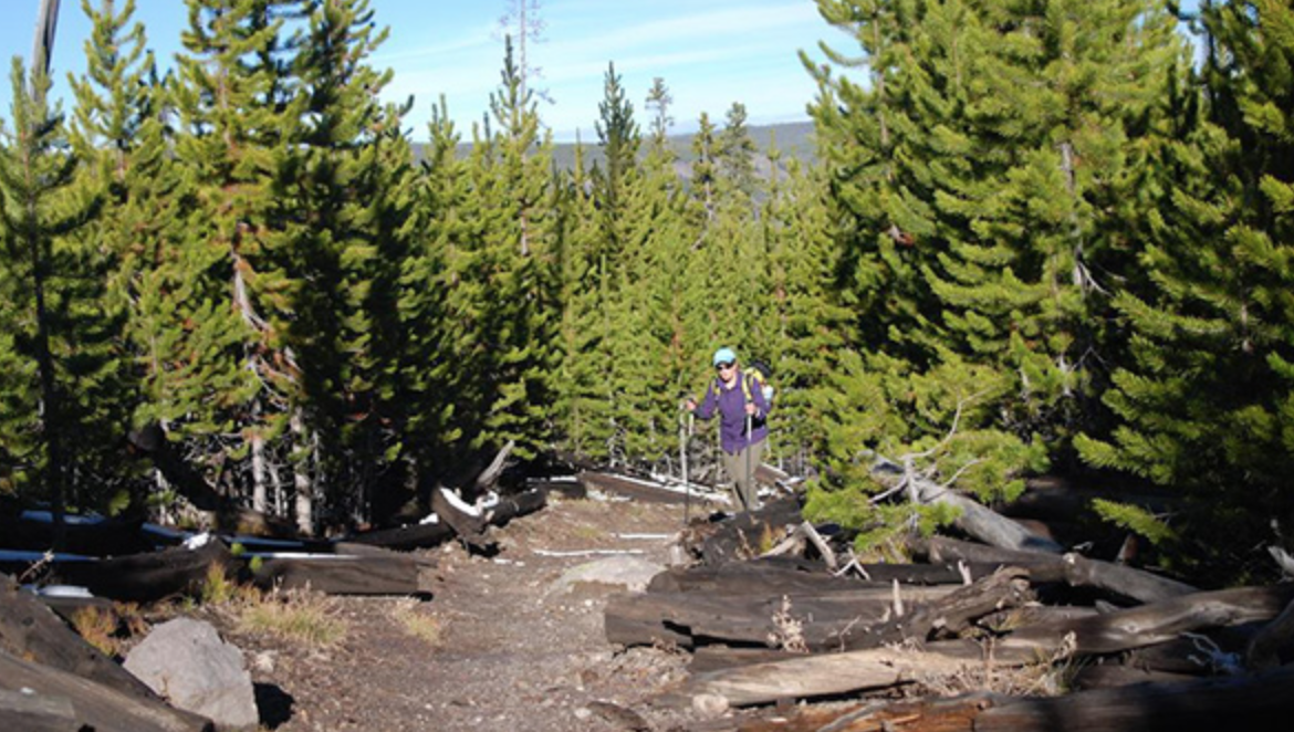
Photo by Kurt Repanshek/ nationalparkstraveler.org


Forlorn Hope: 174 years later, Auburn-area trail team puts itself in Donner Party's shoes

12/27/2020

 
Picture
On Dec. 16, four area ultra runners left Donner Lake on snowshoes to cross the Sierra in a reprise of the 1846 winter journey of the Donner Party’s Forlorn Hope.
Recreating one of the most renowned journeys in American pioneer history, the team wanted to establish the exact route taken by the ill-fated group, attempt to change the known narrative of this moment and tell the story of “these ‘normal’ people who accomplished extraordinary feats and embodied the core characteristics and tenets that became the backbone of America.”
The story of the Forlorn Hope captured the imagination of friends and area trail runners Bob Crowley of Fair Oaks and Tim Twietmeyer of Auburn, for more than seven years leading them to spend much of their spare time delving into every aspect of the story. Elke Reimer of Auburn and Jennifer Hemmen of Fair Oaks completed the team, which combined has completed hundreds of ultra races, including the Western States 100. Twietmeyer is a five-time Western States winner. The group set off on the route researched by Crowley and Twietmeyer, starting with considerably less snow than faced by the pioneers 174 years prior:
“In the winter of 1846, eighty or so members of the Donner Party became snowbound and trapped in the Sierra Nevada mountains. They were among the first pioneers seeking a better life in California. On December 16th, 17 of the original emigrants set out on snowshoes in a desperate attempt to reach a settlement 100 miles away and find help. After enduring punishing physical, mental and emotional hardship, only seven survived. The rest met a terrible fate. Together, this brave group became known as the Forlorn Hope.
Carrying cards featuring details and photographs of each member of the original Forlorn Hope party, the team aimed to spend time reflecting on the enormous ordeal faced by the group in an appreciation of history and human nature in the struggle to survive.
“This will be an opportunity to honor and reflect upon the 17 souls who dared this selfless and desperate act,” commented Crowley.
The team planned for its journey to take five days, camping out for four nights – it took the Forlorn Hope group 33 days to reach help in the Central Valley.
Although far better prepared and equipped than the fated pioneers, the expedition faced a number of obstacles nonetheless, from river crossings to a snowstorm and almost impassable thick whitethorn and Manzanita undergrowth. The steepest climb after their crossing of American River involved 1.5 miles up a 40% slope with 2,000 feet of elevation gain.
Followers tracked the team’s progress via GPS on their website (forlornhope.org). The tracker itself was almost lost close to the site of the Camp of Death – spotted in the snow by Crowley when he turned back momentarily to search for his lost phone (not found!).
The journey of 100.7 miles was completed over five days, and all arrived at the trail’s end safe and well, holding the cards representing the members of the Forlorn Hope. The group held a short commemoration ceremony to the pioneers after being met by a small number of family and friends.
The expedition members aim to further document their experiences via various media – with articles, exhibitions, possible material for schools and plans for a documentary film. They are in contact with several descendants of the original pioneers and hope to meet with some of them in the coming year.
Comments from the team
Crowley: “We are proud and honored to have been able to do this and bring attention to the Forlorn Hope and the hope, the positive side, of what they inspire in people, which is ordinary people doing absolutely extraordinary things. We can all do it. It is inside us and at this time of year and what we've been through, this can bring us all back together as a country and as a world.”
Hemmen: “We still don't know how the seven Forlorn Hope survivors did it, but now we know why they survived. They survived because they had love, they had family, they had each other and had something greater to live for. Along the way, they had to make some unsavory, difficult decisions, but we can all agree that what these people did was the best of human nature.”
Reimer: “This was not about us. This was about helping others. For the Forlorn Hope, it was about those they left behind and bring back the help that they needed. This was not the end of their journey but the beginning of a series of events to save those left at Donner Lake.”
The expedition, day by day
Day 1
The team completed 20 miles of its 100-mile journey. They camped overnight next to the Yuba River.
From Bob Crowley: “We traveled 20 miles in one day. It took Forlorn Hope four days to reach the same place. These were days of hope for the party. Stanton, their leader, was failing but still with them. They’d made six miles one of the days – very good progress. The sun was shining, skies clear. Little did they know in the next 48 hours it would all change.
“We discussed how hard it must have been to trudge through deep snow, with crude snowshoes and scant provisions. We were on snowshoes 85% of today. It was exhausting!
“The scenery was jaw dropping. A light fog settled over Donner Lake at sunup when we departed. As we ascended to Donner Pass, we turned around to see a magical sight of light, serenity and calm. The still lake with a layer of rising fog lifting to the blue heavens above. A few tears may have been shed.
“We witnessed the same features and topography as the Forlorn Hope: Donner Pass, the snowy meadow of Norden, the boulder field with Devil’s Peak looming behind. Kidd and Cascade Lakes and the Yuba River where we camped.
“The cloud arrived in the evening followed by rain, then heavy wet snow which accumulated upon our tents. Everything was soaked, it was cold, miserable. As it should be since those were precisely the conditions Forlorn Hope encountered. But we had warmth, shelter and provisions – minimal suffering.
“Around our fire pit we swapped stories of the Forlorn Hope and Donner Party for hours. Then, with our bellies full (we burn an average of 12,000 calories a day each) and tongues tired, we crawled into our tents for a long winter’s nap. And dreamt about hope, and what tomorrow would bring.”
Days 2 and 3
The team woke to snow on the morning of day 2, which made for a cold, damp start, just as it was for the original pioneers. The day was more challenging than the team anticipated, with heavy snow and a lot of whitethorn and Manzanita plants to make their way through.
Day 3 was the longest day of the journey, with more than 6,000 feet in elevation gain.
The expedition passed through the Camp of Death, where Crowley reported: “I lost my phone near Camp of Death. I am pretty sure Franklin Graves wanted it so we could communicate in the future. The karma at Camp of Death, when we took a team moment of silence, was stirring. Words cannot express the gratitude and humility we feel from all of your heartfelt messages, stories and support. Onward!”
The group continued across Sawtooth Ridge and downhill to the American River. The river has no footbridge and the water is swift and cold with water 3-10 feet deep in this area. They luckily found a fairly shallow area of the river and safely made it across. The section on the other side of the river is extremely steep and difficult going.
With no trail to follow, they forged a path straight up the canyon. It is believed no one has hiked this area since the Forlorn Hope Party (with the possible exception of solitary prospectors 100 years ago). It took nearly four hours to travel one mile. This steep, rough section called for slow, careful trekking, as they pick their way through poison oak, Manzanita and over slick rocks. Travel was easier along the ridge where they finished the day, 10 miles later, at Camp Night 3.
Elke Reimer reflected: “It is simply unfathomable to imagine the Forlorn Hope party making this journey after so much dispute at the Camp of Death, especially the climb up from the North Fork of the American River.”
Team photographer Keith Sutter reported: “Today was intense and gritty. The team did around 26 miles over the toughest terrain they expect to see. They literally ran into camp in the dark.”
From Crowley: “We traveled 26 miles in one day. It took Forlorn Hope nine days to reach the same place. Over the next nine days, five members of Forlorn Hope would perish.
“As we descended upon Camp of Death, we paused and stood silent in a moment of prayer and reflection. How could we begin to understand the sacrifices these souls made on behalf of their families and the future of American society?”
“On Christmas Eve and Day, Antonio and Franklin Graves are the first to succumb to hypothermia and exhaustion. Next Camp of Death would claim Patrick Dolan and young (age 12) Lemuel Murphy. What a horrendous place to be trapped by a raging snowstorm, no fire, chilled to the bone, surrounded by death.
“Days later the sorry troupe emerged and pressed on, completely lost and having crossed the thin veil of civility. Yet Fate wasn’t through with this band of pioneers.

“After emerging from Burnett Canyon and cresting Sawtooth Ridge, they managed their way along heading generally WNW. Then it happened. As they rounded a corner, to their left the thick forest of trees opened briefly to reveal a most magnificent view: the Sacramento Valley! Oh sweet Lord, we see our destination. 15 days after departing the lake they’d laid eyes upon terrain that was green and lush – the promised land they had sacrificed so much to see. Now it laid before them, many, many miles and canyons away. How their emotions must have swung from euphoria for the sight to despair for the massive distance they still must travel.”

“As we began our descent from Sawtooth Ridge into the jagged jaws of NFAR, another sign: We came upon a dead deer right u the middle of our trail. What in the ...?
In all the years we’ve been scouting in the North Fork (NFAR), we’d never encountered any large animals.”
Day 4, as described by Reimer: “Day Four of our expedition is done! We began our day in Iowa Hill, descending into the canyon again before crossing the North Fork in the fog. It was beautiful, but by far the coldest experience we have had the entire way. It’s hard to imagine the Forlorn Hope making that cold descent & crossing the river in layers of heavy clothing, completely starved. We warmed up as we climbed out of the canyon, finally meeting the sun. From there, made our way toward Hwy 49 where we will spend our final night. Tomorrow, it’s about 23 miles to Johnson’s Ranch. What an incredible experience this has been.”
On the morning of Day 5, Keith Sutter reported: “They had a brisk start with the temperature at 26º. They ran to stay warm and cherished the first rays of sunlight. They were on cloud nine.”
Crowley posted an update from the trail: “In about one hour we will set foot on the Johnson Ranch property. Then, 1.5 miles later we will end our journey precisely on the site of the Johnson Ranch adobe house where the seven Forlorn Hope were brought, ending their 33 day journey. There we will pay a final tribute to these courageous American pioneers.
God bless the Forlorn Hope. God bless all of you who have supported us. And God bless America.”
The team arrived at Johnson’s Ranch at around 3:30 p.m., as planned, and held a small celebration to honor the Forlorn Hope.

To read the complete article and see the original photos in Gold Country Media, CLICK HERE.


Picture
Picture

Uncertainty and Strife: PCT Thru-Hiking Permits in the Time of COVID-19

12/18/2020

 
Picture
"The U.S. Forest Service told 2020 Pacific Crest Trail Long-distance Permit holders that they could “no longer complete a planned long-distance trip” and the Pacific Crest Trail Association began advising against non-self-sustained hikes."As 2020 winds down, a third wave of COVID-19 infections is engulfing the United States, with the number of daily cases more than tripling over the previous August high and deaths spiking over 3,000 per day for the first time.
In March 2020, as the pandemic took off, the organizations managing the three Triple Crown trails took a unified cautious approach.
  • The Appalachian Trail Conservancy asked all hikers to stay off or leave the trail.
  • The U.S. Forest Service told 2020 Pacific Crest Trail Long-distance Permit holders that they could “no longer complete a planned long-distance trip” and the Pacific Crest Trail Association began advising against non-self-sustained hikes.
  • The Continental Divide Trail Coalition urged long-distance hikers to postpone CDT travel if they were “unable to budget for the possibility of paying for a hotel room, food delivery, and medication for two weeks in the event that you are exposed to COVID-19,” and canceled its southern-terminus shuttle service.

Outdoors: A Safe Place to BeWith thru-hiking season fast approaching — many northbound hikers begin the Appalachian Trail in February and the Continental Divide Trail and Pacific Crest Trail in March — it remains to be seen how the pandemic will affect those who are planning 2021 hikes.
Nine months into the pandemic, the overwhelming scientific consensus is that the chances of transmitting or contracting the virus in well-ventilated, non-crowded outdoor environments – such as a trail, park, or beach – is exceedingly low.
“Outside, things like sunlight, wind, rain, ambient temperature, and humidity can affect virus infectivity and transmissibility,” Angela Rasmussen, virologist at Columbia University, told Vox. “So while we can’t say there’s zero risk, it’s likely low unless you are engaging in activities as part of a large crowd — such as a protest.”
According to the largest study to date, of more than 7,300 COVID-19 cases examined in China, just a single one was attributed to outdoor transmission — and in that case, a man contracted the virus after speaking in close proximity for an extended period with a person who had recently returned from Wuhan, where the outbreak started.
In addition, early concerns about “fomite transmission” — picking up the virus from surfaces, as with norovirus — have receded as studies confirm the vast majority of cases are due to human-to-human and airborne contact.
“The chance of transmission through inanimate surfaces is very small, and only in instances where an infected person coughs or sneezes on the surface, and someone else touches that surface soon after the cough or sneeze (within 1–2 hours),” a group of researchers wrote in the British medical journal The Lancet in August.
Still, the risk of contracting and transmitting the virus increases when hikers visit trail towns. Concerned equally about the well-being of hikers and the communities they visit, the PCTA continues to discourage long-distance travel unless it’s fully self-supported.
“You can help limit the spread of COVID-19 by avoiding communities other than your own,” the organization advises. “Being completely self-supported on PCT outings is key: if you bring everything you need, don’t stop anywhere traveling to and from the trail and avoid side trips from the trail to resupply, you limit transmission of the virus between you and others.”
The latest research suggests that SARS-CoV-2 is not likely to be picked up from surfaces, particularly outdoors. Clay Bonnyman Evans photo.

PCT Long-distance Permit
One issue haunting prospective 2021 hikers is the availability of permits to hike through public lands, including national parks, wilderness areas, and state parks.
Permits are relatively straightforward and few for both the AT (three required) and CDT (seven required), most for national park access. As of mid-December, national parks were open and the ATC opened its voluntary hiker registration Dec. 1.
But the PCT is a different story, since the trail requires numerous permits to pass through public lands managed by numerous state and federal agencies. The long-distance permit, established in 2001, was created by the U.S. Forest Service, PCTA, and other management agencies to streamline the process. It covers all permit-required areas on the trail, eliminating the need to secure local permits, but is not required.

Since 2015, PCT Long-distance Permits have been limited to 50 per day for hikers starting at the southern terminus in Campo, Calif. in March, April, and May. Intended to spread out the number of hikers to protect resources and improve the experience, the new system has drawn criticism, including:
  • Applicants must sometimes wait online as long as four or five hours online when applications open (typically on Oct. 15 and again on Jan. 15).
  • Each hiker can obtain just one permit, so those planning to hike together often cannot get permits to start the same day, week, or sometimes even month.
  • Some who don’t use their permits may fail to inform the PCTA, eliminating that spot for another hiker.
  • Hikers must “travel continuously” and complete the Sierra Nevada within a 35-day window or lose their permit, which some worry will encourage people to hike in dangerous conditions.
“If it’s a regular snow year, 30 days is plenty to get through the Sierra,” says Jackie “Yogi” McDonnell, author of Yogi’s Pacific Crest Trail Handbook and owner of Triple Crown Outfitters in Kennedy Meadows, southern gateway to the Sierra. “But for people who get here at the end of April, it might take them almost two months.”
The PCTA advises hikers not to put themselves in a dangerous situation for any reason and urges flexibility.
“Stay within your skill set. If you’re hiking somewhere, and you hit something that is not in your skill set, find a way around,” Anitra Kass, Southern California Regional Representative for the PCTA, told The Trek’s Backpacker Radio. “If you need to flip-flop, you can work with our Sacramento office to figure out how to get that done. … They are going to work with you to figure out what is good for you to have a good PCT experience.”

Uncertainty for 2021
The PCTA signaled continuing uncertainty over the upcoming thru-hiking season in August, when it canceled the Oct. 15 application opening. The organization said it would “continue to monitor the situation closely and … update everyone about potential 2021 permits by January 15.”
If PCT Long-distance Permits are canceled entirely for 2021, anyone still intending to thru-hike will face the daunting task of obtaining multiple permits issued by a bewildering array of agencies.
A difficult task. But not impossible.
“Because the PCT Long-distance Permit covers you for your entire thru-hike, it is obviously the easiest option,” McDonnell says. “However, you can absolutely, positively, legally, hike the PCT using local permits.”
But if anyone thinks they can get away with skipping permits, McDonnell warns that enforcement is real, and costly.
“Some people complain and say, ‘the permit doesn’t mean anything to me.’ That’s a mistake,” she says. “I’m not anti-permit. I’m pro-permit – it protects the wilderness, and nobody wants the trail to be overcrowded. The system is there, and we need to work within it.”
Editor’s note: Although it is possible to legally hike the PCT without a Long-distance Permit, we encourage prospective thru-hikers on ALL trails to carefully weigh the risks involved.

CLICK HERE to see the full length article and photos in The Trek magazine.
Picture

Cronan Ranch receives trail improvements

12/11/2020

 
Picture
The BLM Mother Lode Field Office constructs and reshapes parts of the Cronan Ranch Regional Trails Park trail system.
​
For much of this arduous work, they use a trail dozer which is a powerful workhorse that enables them to blade a new trail with ease, as long as soil moisture levels are favorable. The trails at Cronan Ranch continuously need attention to keep them usable for the public and our BLM staff do an incredible job making that happen! (BLM CA Website)

Overview
Cronan Ranch Trailhead is located in Pilot Hill, California. The area contains 12 miles of trails for hiking, biking, horseback riding, fishing, bird watching and other passive recreation. There is a wide variety of terrain to choose from, including gently sloped to challenging hills, oak woodland and gentle riverfront trails. Each season offers a diverse experience.

The land for Cronan Ranch and river trail corridor was purchased by the American River Conservancy, BLM and other partners over a period of 16 years and placed into public trust to be used for recreation and wildlife conservation. The purchase was made possible through generous donations by individuals, private foundations and government agencies, including the Wildlife Conservation Board and the California State Resources Agency.

Cronan Ranch connects with the South Fork American River corridor trail that runs from Greenwood Creek to Salmon Falls. For more information, see our South Fork American River webpage.

What you need to know:
  • Cronan Ranch is a Day-Use area only. No overnight camping.
  • Only non-motorized recreational activities such as hiking, mountain biking, horseback riding and other similar passive activities are allowed.
  • Portions of this trail system border private property. Please respect the rights of private property owners by staying on designated routes at all times.
  • Please be aware that there are mountain lions and rattlesnakes in the area.
  • Fireworks are prohibited.
  • Fuelwood cutting and collection is prohibited.
  • A Special Recreation Use Permit is required for all commercial, organized groups, or competitive activities.

Pack it in - pack it out... and pack a little extra if you can. Help us keep this area clean.

Other BLM Trailheads:
Magnolia Ranch Trailhead
Greenwood Creek River Access
Return To: BLM, Mother Lode Field Office
Cronan Ranch Trailhead website:
https://www.blm.gov/visit/cronan-ranch-trailhead
Picture

BLM - Recreate responsibly close to home

12/11/2020

 
Picture
                   Check our website to see BLM lands close to your home.
​
Be Prepared
  • Plan ahead and be prepared to change your plans.
  • Check with local offices for current conditions, including closures and changes in service, before visiting popular areas and visit blm.gov for operating status updates.
  • Choose dispersed camping where possible instead of developed campgrounds, where social distancing may be difficult.
  • Please “pack it in and pack it out” as trash collection may be limited.
  • Bring soap, water and hand sanitizer with you and have patience as we continue to transition our operations.
Be Flexible
  • Have a backup plan to avoid crowded high-use areas. If you find an area to be crowded, turn around.
  • Avoid congregating at trailheads and popular areas, and maintain group sizes consistent with federal, state, and local guidance.
  • Visit public lands during non-peak hours whenever possible. Consider visiting public lands during a weekday.
Be Respectful
  • Do your part -- practice social distancing and recreate responsibly. Be considerate of others enjoying the outdoors by giving them as much space as possible in parking lots, at trailheads, and out on public lands.
  • Avoid unnecessary risks while recreating to prevent overwhelming medical facilities.
  • Know the rules and regulations to help prevent resource damage.
  • Please respect closures that have been implemented for public safety. Violating a closure order could result in fines or imprisonment.
Stay Safe
  • Stay home if you don’t feel well or have recently been sick.
  • Follow guidance from local, state, and federal authorities.
  • While the BLM will do its best to manage public lands for public health and safety, you are responsible for deciding what is safe. Take responsibility for your safety and wellbeing.

​             https://www.blm.gov/site-page/blm-california-covid-19-updates#recreate

With new Laursen acquisition, PLT now protects over 8,000 acres along the Bear River and Coon Creek watershed

12/10/2020

 
Picture
Placer Land Trust has permanently protected the Laursen Bear River Preserve north of Auburn, making the total of that preserve 546 acres. 

The expanded Laursen Bear River Preserve, along with other adjacent preserves, creates a block of more than 8,000 contiguous acres of protected lands in the Bear River and Raccoon Creek watersheds.

T
hese expansive oak woodlands support healthy and diverse populations of plants and wildlife. The preserve provides critical habitat for animals such as mule deer, mountain lion, grey fox, hawks and many others.

“This property was on the market and certainly would have been developed had the original landowners, Andy and Shana Laursen, not agreed to sell it to Placer Land Trust instead,” shared Placer Land Trust Executive Director Jeff Darlington. “We are so grateful to Andy and Shana for working with Placer Land Trust to protect their 546 acres of land along the Bear River.”

The Laursens were key funders of Placer Land Trust in the early 2000s to help the nonprofit remain sustainable. In 2005, the couple provided funds for Placer Land Trust to purchase the Shutamul Bear River Preserve, adjacent to the Laursens’ land. Placer Land Trust recognized the Laursens for their conservation work with the 2010 Placer Conservator Award.

The property also has a rich human history. Andy Laursen feels the land is special because, as he explains, “People have lived on this land for probably thousands of years. There’s been Native Americans, there’s been Basque sheepherders, there’s been gold miners. And we bought all this land to keep it the way it is, to keep it natural.”

Placer Land Trust plans to share the land with the public through docent-led activities starting in 2021.

“The interfaces between urban and wild spaces are so important,” says Patty Schifferle of Emigrant Trails Greenway Trust, one of the funders of the project. “These places are vital not only for wildlife and the health of our watersheds but for the health of our communities. Blue oak woodlands are quickly vanishing with pressure from urban development, and now is the time to protect them for generations to come.”

The funding needed to acquire the Laursen Bear River Preserve was provided by the Sierra Nevada Conservancy and Wildlife Conservation Board, agencies of the state of California under the California Drought, Water, Parks, Climate, Coastal Protection and Outdoor Access For All Act of 2018 (Proposition 68), and from the California Department of Fish and Wildlife and private sources, including Emigrant Trails Greenway Trust, the Laursen family and Placer Land Trust members.

CLICK HERE to see the original article and photo in Gold Country Media.
Picture

Update for Dec. 11 - COVID-19 campground closures for local State Parks

12/9/2020

 
Picture
Updated: Dec. 9, 2020 (12:00 p.m.) for closures Dec. 11, 2020
California is seeing the largest surge in COVID-19 cases since the start of the pandemic. If case rates and hospitalizations continue at their current rate, it will be a few weeks from California reaching ICU capacity.

On December 3, California issued a Regional Stay at Home Order to stop the surge of COVID-19 cases, prevent a strain on the health care system and help protect critical care for patients.
The new order will be implemented regionally once there is less than 15 percent ICU capacity remaining in our designated regions:​
  • Greater Sacramento: Alpine, Amador, Butte, Colusa, El Dorado, Nevada, Placer, Plumas, Sacramento, Sierra, Sutter, Yolo, Yuba 

​State Parks will temporarily close campgrounds and keep day use areas open in regions impacted by the Regional Stay at Home Order triggered by ICU capacity.
The department appreciates your understanding during these challenging times as reservations will need to be canceled.
Whether your specific reservation will be canceled depends on whether the campground you have reserved is located within one of the impacted regions. If the campsite is within an impacted region, your reservation will be canceled possibly with little advance notice due to the critical need to stop the COVID-19 surge. Affected reservation holders will be contacted by ReserveCalifornia via email and provided with a refund. Reservation cancellations and refunds will be automatic. As such, visitors do not need to take any action. However, please note that due to the volume of visitors affected, the refund process may take some time. Thank you for your patience and understanding during these unprecedented times.

Greater Sacramento area, effective December 11
Below is a list of park units impacted by the campground closures. All campground sites within the park units will be closed in accordance with the Regional Stay at Home Order or local public health orders.
Alpine County
  • Grover Hot Springs SP 
Amador County
  • Indian Grinding Rock SHP
Butte County
  • Lake Oroville SRA
Colusa County
  • Colusa-Sacramento River SRA (operated by City of Colsa)
El Dorado County
  • Ed Z'berg Sugar Pine Point SP
Placer County
  • Auburn SRA
  • Folsom Lake SRA
Sacramento County
  • Brannan Island SRA (operated by American Land and Leisure)

Starting today, California Regional Stay at Home Order Triggered by ICU Capacity

12/5/2020

 
Picture
The public health order takes effect at 12:59 p.m. on December 5. Thereafter, if a region falls below the 15 percent ICU threshold, it will have 24 hours to implement the Stay at Home Order. 

Regional Stay at Home Orders will require Californians to stay at home as much as possible, close operations for certain sectors and require 100 percent masking and physical distancing in all others. This affects us:

  • Outdoor Recreational Facilities: Allow outdoor operation only without any food, drink or alcohol sales. Additionally, overnight stays at campgrounds will not be permitted.​

Where in our area?
Greater Sacramento counties: Alpine, Amador, Butte, Colusa, El Dorado, Nevada, Placer, Plumas, Sacramento, Sierra, Sutter, Yolo, Yuba.Regions will remain in the Regional Stay at Home Order status for at least three weeks once triggered.

SAHO ICU bed % available as of December 4, 2020 for the 5 regions:
Northern California  20.9%
Bay Area.                21.2%
Greater Sacramento  21.4%
San Joaquin Valley. 14.1%
Southern California. 13.1%


To see where YOUR county stands CLICK HERE.


“Staying home for three weeks is a sacrifice, but if every Californian did that for a month, we could stop this disease in its tracks,” said Dr. Erica Pan, Acting State Public Health Officer. “This public health order strikes the balance between saving lives, providing essential services that we all rely on and still allowing Californians to participate in lower-risk outdoor activities that are crucial for our physical and mental health.”

Counties are eligible to come off the Regional Stay at Home Order after three weeks if their hospital ICU capacity projected four weeks out reaches 15 percent. Counties will return to the Blueprint for a Safer Economy tier determined by their case rate and test positivity after they are eligible to exit the Regional Stay at Home Order.

“We are at a tipping point in our fight against the virus and we need to take decisive action now to prevent California’s hospital system from being overwhelmed in the coming weeks,” said Governor Newsom. “By invoking a Stay at Home Order for regions where ICU capacity falls below 15 percent, we can flatten the curve as we’ve done before and reduce stress on our health care system. I’m clear-eyed that this is hard on all of us — especially our small businesses who are struggling to get by. That’s why we leaned in to help our small business owners with new grants and tax relief to help us get through this month. If we stay home as much as possible, and wear masks when we have to go to the doctor, shop for groceries or go for a hike, California can come out of this in a way that saves lives and puts us on a path toward economic recovery.”

“We know what a struggle this pandemic has been for so many California families, but our actions have saved countless lives,” said Dr. Mark Ghaly, California Health and Human Services Secretary. “This targeted action will preserve vital ICU beds for people who need them — whether they’re COVID-19 patients or someone who has suffered a heart attack or a stroke.”

The terms of the Regional Stay at Home Order closely mirror the March order, with some variations.

Regional Stay at Home Order takes effect Saturday; affects regions with less than 15 percent ICU availability

CLICK HERE to see the complete order.


​

    Archives

    May 2025
    April 2025
    March 2025
    February 2025
    January 2025
    December 2024
    November 2024
    October 2024
    September 2024
    August 2024
    July 2024
    June 2024
    May 2024
    April 2024
    March 2024
    February 2024
    January 2024
    December 2023
    November 2023
    October 2023
    September 2023
    August 2023
    July 2023
    June 2023
    May 2023
    April 2023
    March 2023
    February 2023
    January 2023
    December 2022
    November 2022
    October 2022
    September 2022
    August 2022
    July 2022
    June 2022
    May 2022
    April 2022
    March 2022
    February 2022
    January 2022
    December 2021
    November 2021
    October 2021
    September 2021
    August 2021
    July 2021
    June 2021
    May 2021
    April 2021
    March 2021
    February 2021
    January 2021
    December 2020
    November 2020
    October 2020
    September 2020
    August 2020
    July 2020
    June 2020
    May 2020
    April 2020
    March 2020
    February 2020
    January 2020
    December 2019
    November 2019
    October 2019
    September 2019
    August 2019
    July 2019
    June 2019
    May 2019
    April 2019
    March 2019
    February 2019
    January 2019
    December 2018
    November 2018
    October 2018
    September 2018
    August 2018
    July 2018
    June 2018
    May 2018
    April 2018
    March 2018
    February 2018
    January 2018
    December 2017
    November 2017
    October 2017
    September 2017
    August 2017
    July 2017
    June 2017
    May 2017
    April 2017
    March 2017
    February 2017
    January 2017
    December 2016
    November 2016
    October 2016
    September 2016
    August 2016
    July 2016
    June 2016
    May 2016
    April 2016
    March 2016
    February 2016
    January 2016
    December 2015
    November 2015
    October 2015
    September 2015
    August 2015
    July 2015

    Categories

    All

    RSS Feed

Home
Contact
 Mother Lode Trails is YOUR local volunteer-run trail information and resource website. Here you can find
up-to-the minute information on trail alerts, links and trail news for Placer,  Yuba, and Nevada counties.
Mother Lode Trails is trademarked.