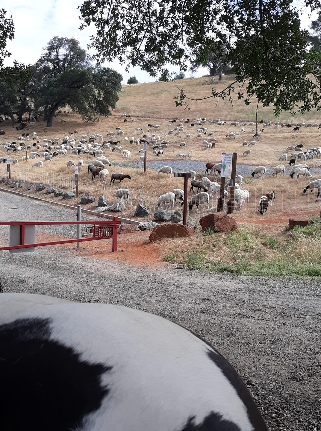
To eradicate weeds and the fire danger they present, Placer County has hired sheep to do the job. These hard working sheep will be there for a few weeks, moving every day to a new area. Please leave them alone and let them do their job.
|
To eradicate weeds and the fire danger they present, Placer County has hired sheep to do the job. These hard working sheep will be there for a few weeks, moving every day to a new area. Please leave them alone and let them do their job.
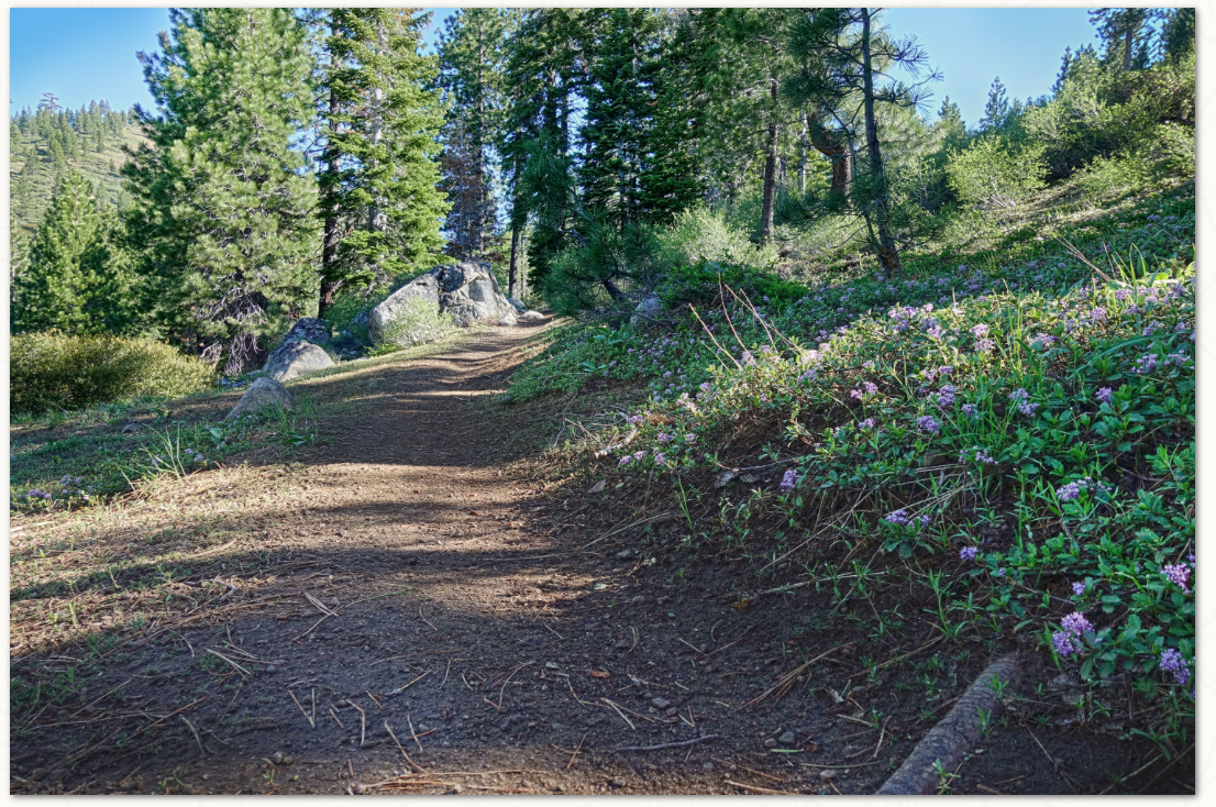 As the massive snows of the winter of 2018-19 finally melt out of the Sierra, Wendin Way is a great trail to start exploring higher elevations to see how spring (even after the first day of summer) is progressing. Right now tobacco brush, mahala mat and manzanita are blooming, with mule's ear, lupin and paintbrush starting as well. The trail starts above Donner Lake, winding through pine, mountain alder, willows and cottonwood. As you start out, you'll see a Truckee River Watershed Council project to help restore the watershed which serves as the headwaters of Gregory Creek draining down to Donner Lake, and up high, all the melting snow from the big winter is feeding springs that will spawn thick colonies of tall bracken fern along the trail later in the summer. Around each corner you'll enjoy different views of Donner Ridge, Donner Lake and the Sierra Crest beyond, still covered in snow. Continuing uphill, the 1.3-mile trail eventually connects with the Donner Lake Rim Trail, though snow drifts still exist if you choose to go higher. The trail is open to hikers, bikers and equestrians and the climb is a steady 500 feet of elevation gain before joining with the Donner Lake Rim Trail. How to get there: Take the Donner Lake Exit on Interstate 80. At the bottom of the ramp, head uphill about 300 yards to the trailhead where there is a parking area with informational kiosks and a map. CLICK HERE to see the original article and photos from the Tahoe Donner Land Trust newsletter. Click here for a map and more information. 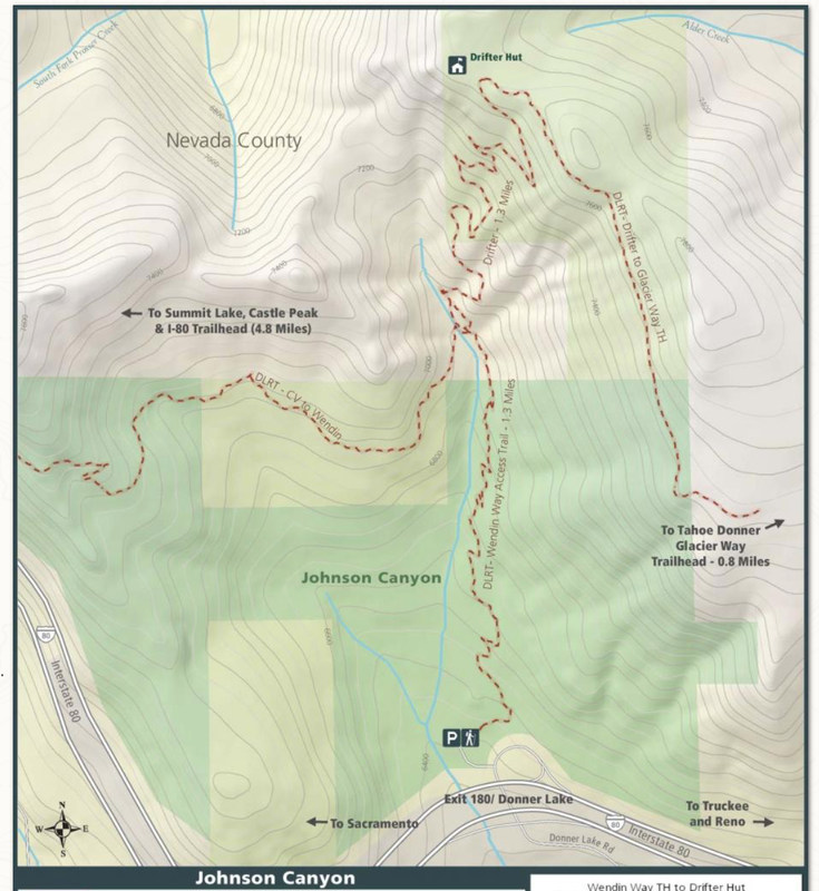 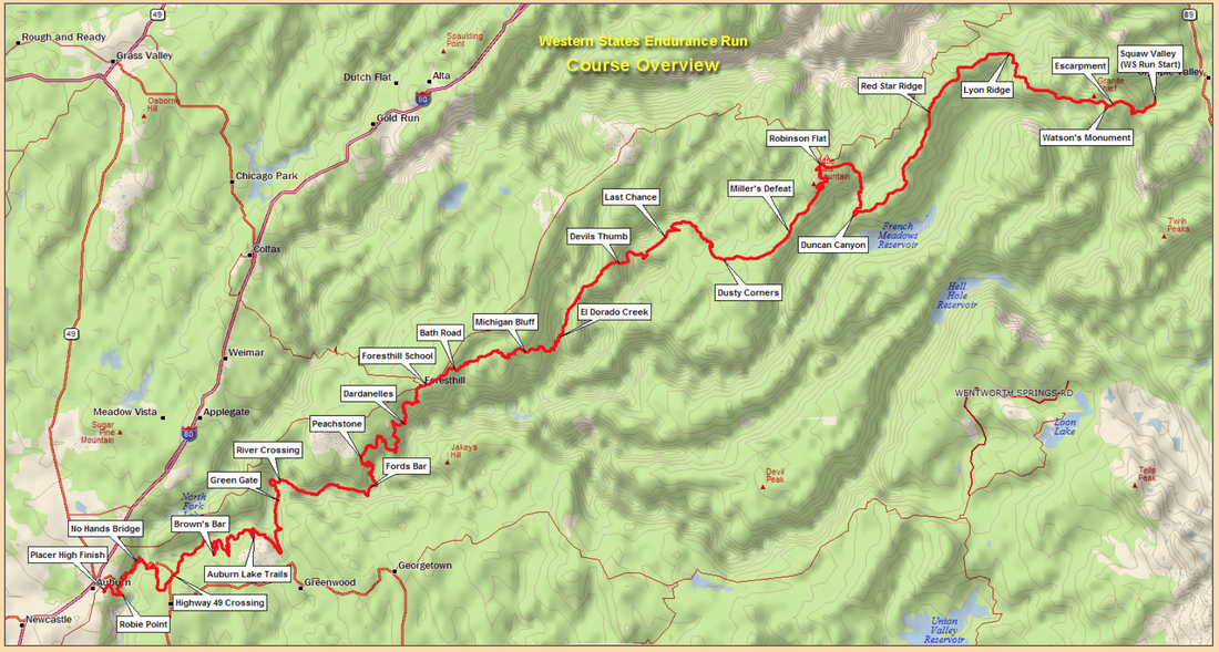 The Western States 100-Mile Endurance Run is the world’s oldest 100-mile trail race. Starting in Squaw Valley, California near the site of the 1960 Winter Olympics and ending 100.2 miles later in Auburn, California, the Western States, in the decades since its inception in 1974, has come to represent one of the ultimate endurance tests in the world. Following the historic Western States Trail (WST), runners climb more than 18,000 feet and descend nearly 23,000 feet before they reach the finish line at Placer High School in Auburn. In the miles between Squaw Valley and Auburn, runners experience the majestic high country beauty of Emigrant Pass and the Granite Chief Wilderness, the crucible of the canyons of the California gold country, a memorable crossing of the ice-cold waters of the main stem of the Middle Fork of the American River, and, during the latter stages, the historic reddish-brown-colored trails that led gold-seeking prospectors and homesteading pilgrims alike to the welcoming arms of Auburn. For more than four decades, the WST has been home to some of the sport’s most stirring and legendary competitions, and has spurred the capacity of spirit of all runners, of all abilities and from all walks of life, from all over the globe. With more than 1,500 dedicated volunteers, offering the sport’s oldest and most prized possession – a sub-30-hour finisher’s bronze belt buckle or a sub-24-hour finisher’s silver belt buckle – and owning 100-mile racing’s richest and most compelling history, Western States remains one of the undisputed crown jewels of human endurance. Out of respect for the run PLEASE REFRAIN from hiking or riding the WST this weekend June 29 - 30. If you'd like to support the run you are welcome to visit runners at Foresthill or the finish at Placer High School stadium for the best spectating. For more information CLICK HERE. 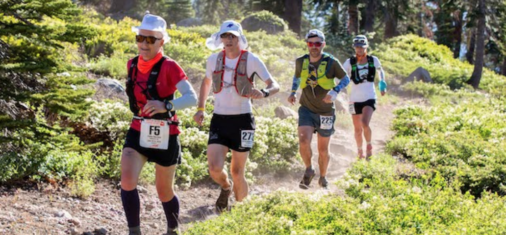 Area affected: Falcon Crest parking area at the intersection of Salmon Falls Road and Falcon Crest Lane.
CA Department of Parks & Recreation will be closing the parking lot for the next four days to lay down a substance called “Dust Off”. This is meant to put a protective layer over the ground that will prevent dust clouds in this area. As this parking area will be temporarily closed, the second entrance that homeowners have reported as using to enter their street safely will also be temporarily closed. The official statement from the California Department of Parks and Recreation is as follows: The Falcon Crest parking area at the intersection of Salmon Falls Road and Falcon Crest Lane will be closed to public access from June 20, 2019 – June 27, 2019 for maintenance. The Old Salmon Falls, Salmon Falls and Skunk Hollow lots will remain open as alternate parking and trail access points during this time. Thank you for your patience while we conduct this necessary maintenance project. Also, the Department of Parks and Recreation reported that they removed two boulders from the middle area of the parking lot, per the request of local equestrian organizations. They now report that these boulders will need to be put back into this location as when they were removed cars returned to the area and returned to their previous activity of spinning donuts, creating large clouds of dust. Submitted by: Chelyssa Berglund District Representative Assemblyman Kevin Kiley, 6th District Phone : (916) 774-4430
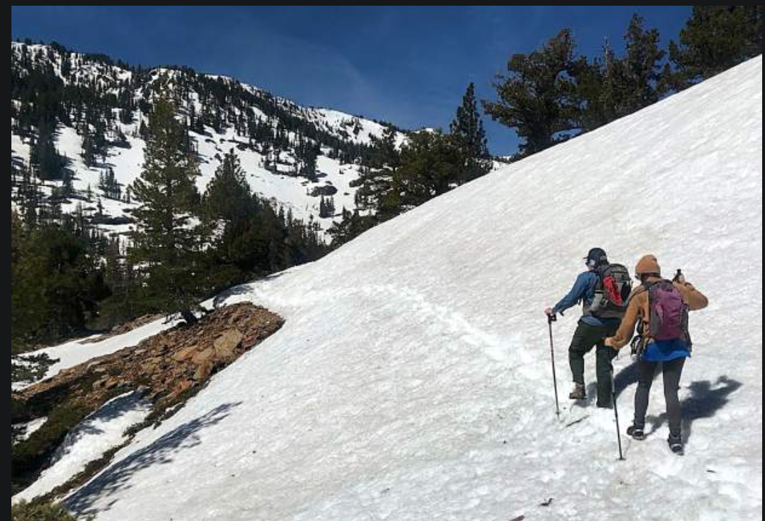
There are a number of hiking options at Lake Tahoe, but for those summit worshippers, mountaintops will likely be difficult to reach until late summer.
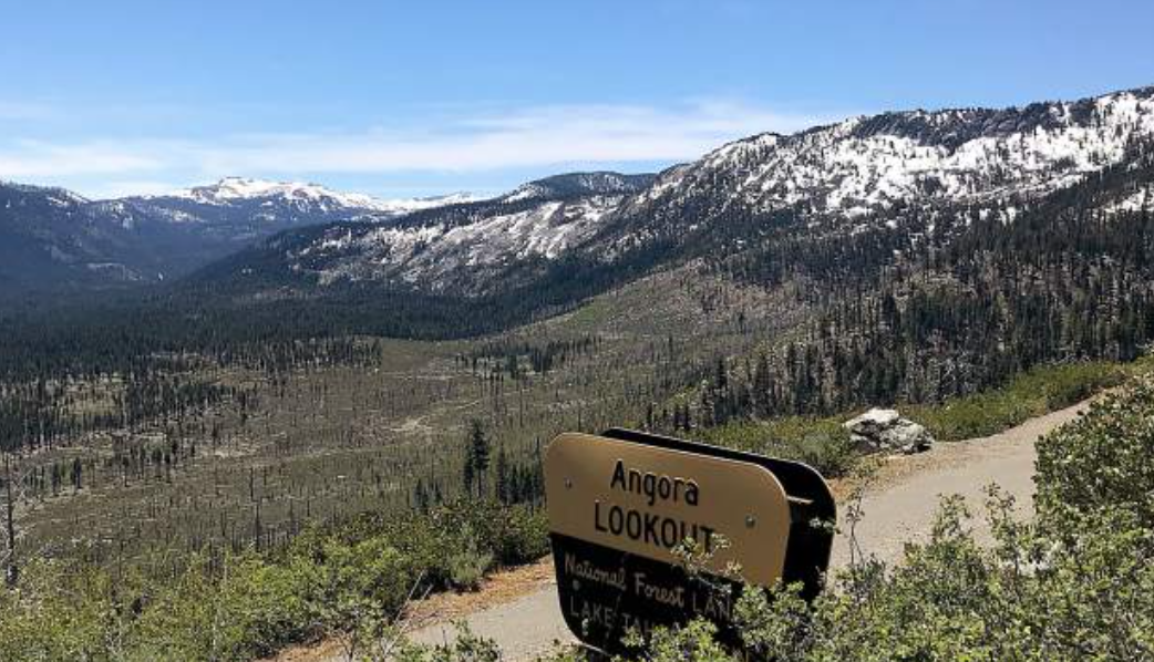
Most hiking trails around the lake that aren’t covered by an historic snowpack, are muddy and wet and resemble streams more than paths. “It is really snowy and wet up high,” said Morgan Steel, executive director for the Tahoe Rim Trail Association. “There are places where the trails are just submerged. We expect it to be like 2017 when the trails didn’t clear out until August. Peak bagging in the Desolation Wilderness is going to be tough, they’re going to be socked in for awhile. But the trails that are open are in great shape.” Steel said the TRTA has had to push back some projects, cancel a youth camp last week and are trying to find ways to work around the snow for future events. Some of the trails Steel said are ready for action include Van Sickle Bi-State Park, the Daggett Loop and Kingsbury North to Kingsbury South, all on Lake Tahoe’s South Shore. She said the east and southern aspects are melting out quicker and Tahoe City to Brockway will likely be the next segment of trail to open. The Angora Ridge Trail with great views of Fallen Leaf Lake and Lake Tahoe is also a good option, especially for mountain biking. Mountain bikers, hikers and horseback riders are all sharing trails not buried. Lisa Herron with the Lake Tahoe Basin Management Unit of the U.S. Forest Service said the snow level is hovering around 7,000 feet, but is rising quickly with the warming temperatures. “The northern facing slopes are still holding quite a bit of snow,” Herron said. LTBMU Wilderness Ranger Shannon Maguire has been patrolling area trails and the common thread in all her trail descriptions is snow and water. The popular Glen Alpine Trail has “boot-top” deep water is some points on much of the trail, the crossing to Grass Lake is raging and the trail is buried in snow well before Susie and Gilmore lakes. At Echo Lakes, patchy snow begins around the end of lower lake and all lakes above Upper Echo are nearly 100% frozen. The Eldorado National Forest also has rangers gathering information in the Desolation Wilderness and added that the trail around Lower and Upper Lake is mostly clear but toward the end of Upper there are “steep, deep fields of snow.” Consistent snow begins between Floating Island and Cathedral lakes on the Mount Tallac Trail; The Bayview Trail is mostly free of snow to Granite Lake, patchy above with solid snow beginning below Maggie’s saddle; Meeks Bay Trail has consistent snow between Genevieve and Crag lakes and the Big Meadow Trail water is high in the meadow and surrounding the bridge. Eldorado National Forest also provided updates for several trailheads. At Loon Lake, the gate is locked to drive to the trailhead, but the trail is in “decent” condition with roughly 20% snow coverage to Spider Lake. Van Vleck/Tells Creek, the road is clear about 4 miles in but has significant snow drifts on the way to the trail. Lyons Creek and Twin Lakes is packed in with snow. Wrights Lake Road is still closed as is the Wrights Lake Recreation Area. At Pyramid Creek, the trail to the base of the falls is free of snow, but in many places the trail is a stream with multiple high-water crossings. Above Horsetail Falls, lakes such as Avalanche and Ropi are still covered in snow and at Ralston, about 2 miles from the trailhead there is snow on the trail. “The temperatures are really warm in the valley and it could be misleading to people coming here to visit,” Herron said. “We just want people to know there is a ton of snow up here and that the water is cold and moving fast.” Mountain bikers have been enjoying good conditions and the Tahoe Area Mountain Biking Association has already had a few trail days where volunteers have helped trail maintenance, including the removal of about 50 downed trees, said club president Ben Fish. “Most of the trails on the East and South shores have melted off to about 8,000 feet and it’s been riding really well,” Fish said. “The volunteers have really helped get us off to a good start this year.” Fish said he rides mostly in the evenings and the crowds sharing trails are scarce. GO EXPLORE, JUST BE SMART AND STAY SAFE If your inner John Muir is screaming at you that the mountains are calling and the need to vanquish summits from your checklist is too strong, then by all means go, just be prepared for the conditions. That means wearing the proper clothing and footwear, food, water and/or filter, compass and map and cell phone or mobile device. Even a small compact stove would come in handy in emergencies for warmth, and food, since fires are not allowed year round anywhere in the Tahoe Basin except for developed campgrounds with fire rings. But a permit is required to operate the stove. Herron said a paper map and compass are ideal because cell service is severely limited in the high country and relying on electronic navigation is unreliable. “Right now a lot of trails aren’t visible,” Herron said. “Proper footwear is also a must, no tennis shoes or flip flops. Ideally, they would be waterproof boots.” Staying on the trail as much as possible is also recommended. Tromping through a foot of mud off the side of the trail to avoid hiking through water creates more work for the people who maintain them. “Have fun with it, go right through the water and get muddy and go right through those snow banks, but be careful,” Steel said. “The stream crossings are raging, there are a lot of slick rocks. You may have done the same crossing in August or whatever, but this year they are very different, so people need to be careful.” The Forest Service has a website “Know Before You Go” (https://www.fs.fed.us/visit/know-before-you-go) that tries to answer all questions about what people can expect when traveling into forests, from what outdoor opportunities there are, to staying safe and avoiding dangers to knowing the weather and respecting wildlife. “We want people to come to Lake Tahoe prepared, have fun and be safe,” Herron said. “When vacation accidents happen, for me, it’s just heartbreaking.” CLICK HERE to see the original article in the Nevada Appeal newspaper. 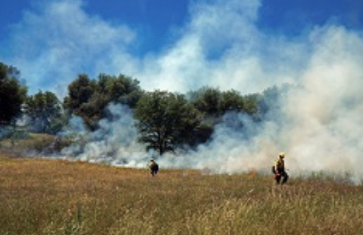 The Bureau of Land Management Mother Lode Field Office is initiating fire restrictions on BLM-managed public lands in Amador, Calaveras, El Dorado, Mariposa, Merced, Nevada, Placer, Sacramento, San Joaquin, Stanislaus, Sutter, Tuolumne and Yuba counties, effective June 14, due to wildland fire danger.
The National Interagency Fire Center predicts the likelihood for large wildland fires will be above normal this summer. An unusually wet winter has produced an abundant grass crop, which has already cured or dried out. These heavy fuel loads have a high potential for creating extreme wildland fire behavior. In the last decade, nearly 90 percent of wildland fires have been human caused. Individuals who spark wildfires, intentionally or unintentionally, may be held responsible for fire suppression and repair costs. The public is advised to be extremely careful when recreating outdoors, carry a shovel and water at all times, and check weather forecasts and fire danger ratings before leaving home. The following restrictions will remain in place until further notice: • No tools powered by internal combustion engines off established roads or trails (such as chainsaws or lawn mowers). • No motorized vehicles off established roads or trails. • No target shooting – hot bullet fragments, exploding targets and metal from recreational shooting can spark a wildfire. Use of firearms for hunting is still allowed. Hunters must abide by State of California laws and regulations. Visit www.wheretoshoot.org for alternative recreational target shooting locations. • No smoking, except within an enclosed vehicle or building, or at a developed recreation site, or other designated areas. • No fireworks, including “safe and sane” fireworks. • No welding or operating acetylene or other torch with open flame. • No explosives. • No campfires, barbecues or open fires, except in a developed campground. Portable stoves with gas, jelled petroleum, or pressurized liquid fuel are authorized with a valid California campfire permit available free at all BLM, Forest Service and CAL FIRE offices or at www.preventwildfireca.org/Permits. The BLM is committed to keeping public landscapes healthy and productive. Wildland fire crews have been using prescribed fire and pile burns this spring to reduce noxious weeds and available fuel loads, increase protection of the Wildland-Urban Interface and improve forest health in the Inimim Forest, Lily Gap and Cronan Ranch. One less spark means one less wildland fire. Learn how you can help prevent wildland fire at http://www.readyforwildfire.org/. A listing of fire restrictions throughout BLM California is available at https://go.usa.gov/xmUEG. For specific questions, please call the Mother Lode Field Office at 916-941-3101. To see the original press release, CLICK HERE. 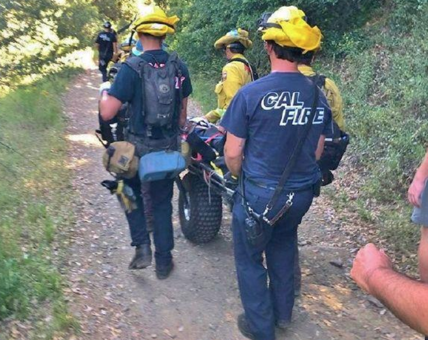 An overheated hiker who ran into trouble on the Stevens Trail near Colfax was safely carried out by emergency personnel.
Cal Fire reported that firefighters with American Medical Response paramedics hiked 1½ miles down the Stevens Trail into the north fork American River canyon to provide medical help to a hiker suffering from heat-related symptoms. The hiker was treated at the scene and then rolled out on a gurney with wheels sturdy enough for trail use. From the trailhead, the hiker was transported by ambulance to Sutter Auburn Faith Hospital in North Auburn. Stevens Trail is a sometimes-steep trail to the north fork that takes 8 miles to travel down and up. Cal Fire is advising only the well-prepared should attempt the hike. Temperatures rose to the low 90s this past week and were expected to drop to the high 80s through at least Monday. ANOTHER HEAT RELATED RESCUE ON MONDAY Rescue personnel were also called Monday to the Hidden Falls Regional Park between Lincoln and Auburn for a similar medical emergency, with a hiker complaining of heat-related symptoms on a trail. MT. BIKE CRASH ON SATURDAY On Saturday evening, Cal Fire-Placer County Fire Department firefighters, State Parks officers and American Medical Response paramedics were called to a mountain bike crash along the Auburn State Recreation Area Culvert Trail, off Old Foresthill Road. Cal fire reported that a mountain biker was found several hundred feet from the road and loaded into the trail-ready “Big Wheel” with basket and brought out to a waiting https://goldcountrymedia.com/news/147513/hiking-heat-dont-mix-on-placer-county-trail/ 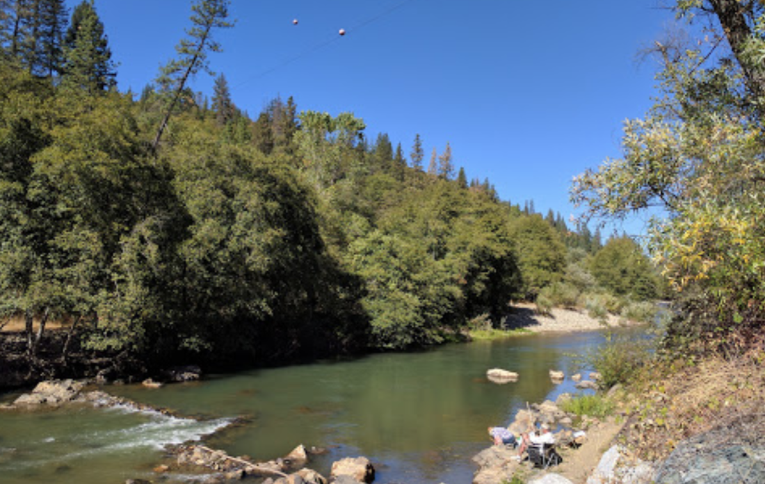 Hidden Gem: Bear River Recreation
Hidden in a lovely canyon running along the Nevada and Placer County borders, the Bear River Recreation Area, between Rollins and Combie Reservoirs, is a little known gem for families and river lovers seeking quiet river recreation. Easy access points near Colfax and Grass Valley offer places to hike, fish, pan for gold, swim, picnic, camp and go tubing on the river. One great spot with free day use parking and access to 250 acres of parkland is the Bear River Park and Campground, with access from Colfax off Milk Ranch or Plum Tree Roads. This spot has a wide, cobble stone beach area with plenty of room to spread out and enjoy a day relaxing on the river. Steep forested slopes surround the recreation and camping areas, and the Bear runs through a diverse ecology of lush vegetation from willows and alders at the river’s edge to towering Ponderosa pines and Douglas firs. A maintained network of trails is easily accessible to hike along the river or into the nearby hills to experience a healthy Foothill river canyon. These forest trails are a favorite for wildflower hikes and bird watching. 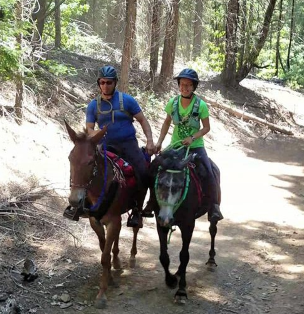 The annual Wild West Endurance ride is this Thursday through Sunday, June 13-16, 2019, based at the Skillman Horse Camp 13 miles east of Nevada City off Highway 20. A request from the Manager of the ride:
"The ride will be on the trails from the Lone Grave area to the Bear Valley area. If possible please choose a different area to ride your mountain bike or dirt bike while the race is happening. Our riders are used to sharing the trail but other users may not enjoy having to frequently pull over to let the horses pass. Thanks for your consideration. We appreciate it!" For more information CLICK HERE.  EL DORADO HILLS, Calif. – The Bureau of Land Management Mother Lode Field Office will temporarily close Cronan Ranch to the public as a precaution on Thursday, June 6, during a prescribed burn of roughly 40 acres of noxious grass and brush, depending on weather and air quality conditions. Cronan Ranch is located near the community of Pilot Hill, in El Dorado County.The BLM will conduct the prescribed burn in partnership with CAL FIRE. The South Fork of the American River pullouts, restrooms and parking lot will remain accessible to commercial outfitters at Cronan Ranch. Nearby Magnolia Ranch, Dave Moore Nature Park and Greenwood Creek River Access will also remain open during the prescribed burn.
The BLM uses an Integrated Weed Management Strategy at Cronan Ranch; weed treatments include herbicide application, sheep grazing and prescribed fire to kill invasive, noxious weeds like Medusa head and yellow starthistle plants, before they have a chance to set seed. Prescribed fire helps increase the diversity of vegetation like native purple needle grass, restores balance to the ecosystem by reducing the available fuel load, and helps minimize fire starts along the trail system. The BLM is committed to keeping public landscapes healthy and productive. The exact timing of the prescribed burn will depend on temperature, wind and relative humidity and is being conducted in close coordination with the El Dorado Air Quality Management District. Smoke may be visible in the communities of Lotus and Pilot Hill. Updated information will be provided on BLM California social media sites using #RxBurn. Cronan Ranch is part of a popular hiking, biking and equestrian trail system that has roughly 30,000 visitors annually. For more information, please call the Mother Lode Field Office at 916-941-3101. CLICK HERE for original press release from BLM. |
Archives
July 2024
Categories |
 RSS Feed