MOTHER LODE TRAILS
  • Home
  • About
  • Contact
  • Volunteer
  • Links
    • Law Enforcement Emergency
    • Federal, State, County Districts Parks & Trails
    • Running Clubs
    • Equestrian Clubs
    • Mt. Bike Clubs
    • Hiking Clubs
    • Trail Advocacy Organizations
    • Phone Numbers State & Federal Parks, Trails & Lands
    • Where to Eat on the Trails
  • News
  • Alerts

New Hoot Trail in Tahoe National Forest BONC SAFETY NOTICE for bicyclists

4/19/2017

 
Picture
Posted from BONC - Bicyclists of Nevada County
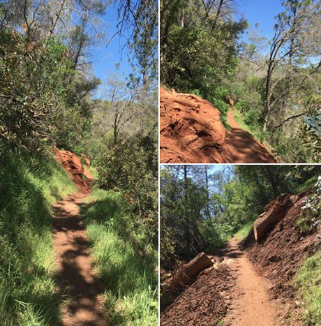
HOOT TRAIL (formerly the Cable Trail)  SAFETY NOTICE
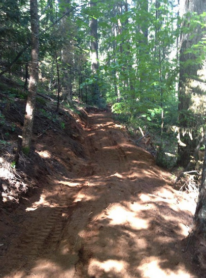
The Hoot trail is now officially open. if you have not been on it you need to check it out. It is a flow trail from Harmony Ridge down to Rock Creek road, near the nature trail.

It was built on Forest Service land as a collaborative effort between BONC and Gold Country Trails Council. Our own Orion put in a huge amount of time and effort to get this built. However the equestrian group (Gold Country Trails Council) put in a large amount of money and time also. This is a multi-user trail. It is open to hikers, equestrians and cyclists.

The trail lends itself to fast riding, with lots of berms and jumps. However it is not a race course. As it is open to all non-motorized users it is imperative to be cautious on your way down and make sure you are able to see that the trail is clear of other users ahead. Do not be "that guy (or girl)" who causes an incident or injury to other trail users. Everyone has the same right to be out there, and everyone has the same right to feel safe from cross-user conflict. Remember that an equestrian encounters multiple cyclists on every ride, proper etiquette and manners allows us to all get along."

April 15 - Nevada City Dirt Classic - USACycling California Mountain Bike XC Championships, Race #1 - Tahoe NF

4/11/2017

 
Picture
"Nevada City Dirt Classic" is a state championship series for USA Cycling and will be pre-racing on Friday and racing this Saturday on the Pioneer, Harmony, Hoot (old Cable Trail) and the Dascombe Loop in the Tahoe National Forest. The race central will be at the Gold County Trails Council Equestrian Trailhead on Conservation Road off Highway 20, about 12 miles above Nevada City.
YBONC presents the 2017 Dirt Classic XC Series Races as follows:
Race #1: April 15, 2017 on Trails: Pioneer/Harmony/Hoot/Dascombe Loop, Tahoe National Forest
Race #2: May 7, 2017 on Trails on Osborne Hill Loop, Grass Valley
Race #3: May 20, 2017 on Trails Pioneer/Hallelujah Loop, Tahoe National Forest
for more info on these races: <http://ybonc.org/events/dirt-classic/>


Spenceville Wildlife Area cattle round up April-May dates

4/5/2017

 
Picture
Every year, the grazing cattle are rounded up in the Spenceville Wildlife Area corrals. It makes the corral area busy and they add an extra corral, which takes up space at the trail head. The cowboys are always polite and share the space, but this is an alert so you know what to expect if you wish to hike or ride there.
This year, the dates will be:
4/10
4/13
4/20
4/30
5/1
5/8
When a Mother Lode Trails reporter parked there today, the cowboys said they will be starting at dawn on these dates

BLM asking all trail user group events to obtain permits for Cronan Ranch

4/4/2017

 
Picture
As this sign explains, so BLM can manage Cronan Ranch better, all trail users' groups planning events in Cronan Ranch are being asked by the BLM to contact them to get the proper permits.
Call 916-941-3101.

Trail closures Cronan Ranch, South Fork American Trail and Magnolia Ranch Trail head for weed spraying

4/4/2017

 
Picture
BLM warning sign that maintenance crews will be spraying for star thistle in the locations these dates:
April 10 through 14, 2017
and
April 17 through 21, 2017
Those who want updated information can call the BLM Mother Lode Office at (916) 941-3101for any further information.

1,100 mt. bikers race in 'Granite Bay Grinder' April 8-9

4/4/2017

 
Picture
On April 8 and 9 more than a 1,100 high school mountain bikers will be riding the course on trails in Folsom Lake Granite Bay. Dubbed the Granite Bay Grinder, this race course is known for having miles of singletrack, several technical sections, mud, sand, big beautiful oak trees, tall grass and a gorgeous view of the now full Folsom Lake. With numbers this large they have the races broken down into 11 categories of competition.

Come check out these fearless high school mountain bikers as they rip through the course in hopes of making it to the podium. For more information, go HERE.

CLICK HERE to see the complete article and photo in Placer Sentinel.


BLM starting to enforce parking at Cronan Ranch staging areas

4/3/2017

 
Picture
Several trail users have reported that the BLM Rangers have started warning and ticketing autos that are illegally parked at the Pedro Hill staging area. The parking area is clearly signed and marked where the horse trailers are to park in one area, and the autos in another. When the autos don't park properly, it causes safety issues and fewer people can access the park.
Several years ago BLM opened the more spacious Magnolia staging area 1.5 miles farther south down Hwy 49, directly across from Venizio Winery. But on busy weekends, both staging areas are filled to overflowing. Compounding the problem, Magnolia staging has had a rash of directional signs being stolen or defaced, leaving visitors unclear where to park.
Cronan Ranch Regional Trails Park is located in Pilot Hill and contains 12 miles of trails for hiking, biking, horseback riding, fishing, bird watching and other passive recreation. The borders of the Park follow the South Fork American River, Highway 49, Pedro Hill Road and private lands. Because of its varying terrain and beauty, the park has become increasingly popular.
BLM has done what they can with their existing staging areas and there are plans to expand parking in the future.

First rattlesnakes of the season reported at Cronan Ranch

4/2/2017

 
An equestrian riding at Cronan Ranch today saw three rattlesnakes lying across the trail, sunning themselves. The snake season is starting, so beware, the snakes are leaving their dens and looking for something to eat and bask in the sun. Hikers should be wearing boots and long loose pants; mt. bikers slow down so you don't run over them (and get bit in the process), and equestrians should really listen to their horses who can hear and smell them way before their riders can.
SNAKE FACTS
Most people bitten by rattlesnakes have inadvertently stepped or risen over them. They detect movement by sensing vibrations in the ground. Their eyes see well even in low light. Rattlesnake bites can be dangerous but are very rarely fatal to humans. With proper medical treatment, including antivenin, bites are usually not serious.
The smaller the snake, the more deadly, as they haven't learned how to measure out their venom. Young rattlesnakes do not yet have their rattles, though they are as dangerous as adults, according to the National Park Service at Yosemite. Furthermore, some adults may lose their rattles, so it is a good idea look out for the triangular head. And, especially in Folsom Lake and Auburn SRAs, a percentage of the rattlesnakes don't rattle at all.
After the rattle, rattlesnakes’ most distinctive physical feature is their triangular head. Also, they have vertical pupils, like cat’s eyes.
Generation after generation of rattlesnakes will use the same dens, sometimes for more than 100 years. Upon leaving their dens, they like to sun themselves on rocks and other open places. Though they are not nocturnal, in the hot summer months they may be more active at night.
Despite their venom, rattlesnakes are no match for California King snakes, which are fond of putting them on their dinner menus. DON'T KILL CALIFORNIA KING SNAKES! (picture below the rattlesnake.)

Here is a RATTLESNAKE

Picture

Below is a safe and desirable CALIFORNIA KING SNAKE:
Picture

Trees and mudslide are cleared on Pioneer Express at Trail Mile Marker 51.5

4/2/2017

 
Picture
California State Parks hired the California Conservation Crew crew to assist with the work to clear the Pioneer Express Trail. Since the AR50 Run and the American River Classic Endurance Ride uses this trail, it was important it was cleared before those big events.

Forest Service: do not use the Cable Trail until officially open

4/2/2017

 
Picture
This past year, volunteers' and the Tahoe National Forest crews' hard work has created the newly routed Cable Trail, to be renamed "Hoot Trail." It has taken several years to clear all the hoops required by several agencies, and the trail's official opening is eagerly anticipated. TNF is working on a dedication event.

Because of the trail's fragile state, the Forest Service posted the trail closed, and has requested several times this past year for all users to stay off this trail until the trail bed settles. If the trail is used before it's ready, work will have to be repeated and delay the official opening even farther.

Regardless of signs and requests, it has been reported that are hoof tracks and bike tracks. This selfish misuse of the trail will require additional work to make this trail ready for everyone to use. Again, the request is made: please don't use the Hoot (Cable) Trail until the official opening later this year.

Photo of the trail re-route work done last May by BONC, TNF and Gold Country Trails Council.


<<Previous
Forward>>

    Archives

    November 2025
    October 2025
    September 2025
    August 2025
    July 2025
    June 2025
    May 2025
    April 2025
    March 2025
    February 2025
    January 2025
    December 2024
    November 2024
    October 2024
    September 2024
    August 2024
    July 2024
    June 2024
    May 2024
    April 2024
    March 2024
    February 2024
    January 2024
    December 2023
    November 2023
    October 2023
    September 2023
    August 2023
    July 2023
    June 2023
    May 2023
    April 2023
    March 2023
    February 2023
    January 2023
    December 2022
    November 2022
    October 2022
    September 2022
    August 2022
    July 2022
    June 2022
    May 2022
    April 2022
    March 2022
    February 2022
    January 2022
    December 2021
    November 2021
    October 2021
    September 2021
    August 2021
    July 2021
    June 2021
    May 2021
    April 2021
    March 2021
    February 2021
    January 2021
    December 2020
    November 2020
    October 2020
    September 2020
    August 2020
    July 2020
    June 2020
    May 2020
    April 2020
    March 2020
    February 2020
    January 2020
    December 2019
    November 2019
    October 2019
    September 2019
    August 2019
    July 2019
    June 2019
    May 2019
    April 2019
    March 2019
    February 2019
    January 2019
    December 2018
    November 2018
    October 2018
    September 2018
    August 2018
    July 2018
    June 2018
    May 2018
    April 2018
    March 2018
    February 2018
    January 2018
    December 2017
    November 2017
    October 2017
    September 2017
    August 2017
    July 2017
    June 2017
    May 2017
    April 2017
    March 2017
    February 2017
    January 2017
    December 2016
    November 2016
    October 2016
    September 2016
    August 2016
    July 2016
    June 2016
    May 2016
    April 2016
    March 2016
    February 2016
    January 2016
    December 2015
    November 2015
    October 2015
    September 2015
    August 2015
    July 2015

    Categories

    All

    RSS Feed

Home
Contact
 Mother Lode Trails is YOUR local volunteer-run trail information and resource website. Here you can find
up-to-the minute information on trail alerts, links and trail news for Placer,  Yuba, and Nevada counties.
Mother Lode Trails is trademarked.