By Mary West - Hiking the WST after the Trailhead fire - I was all set to wax poetic about the glorious Western States Trail (WST) a couple weeks ago. Then the Trailhead fire started.
Now I feel a need to report what I know. According to state park officials 1/2 to 3/4 of a mile of the historic trail is within the fire boundary from Ford’s Bar to Peachstone. It is unclear how the damage may affect the upcoming Tevis Cup Ride.
Reports are coming in daily now that roads are slowly reopening and Tevis trail crews can get a look.
Tevis is set for July 23. The route is somewhat flexible so we will keep a close eye on developments concerning the safety of the riders and their mounts.
Fire is not new to the Western States Trail. We lost the swinging bridge a few years ago in the American Fire.
The events will go on. Time will heal these wounds, and we will hike this trail.
Ready to hike
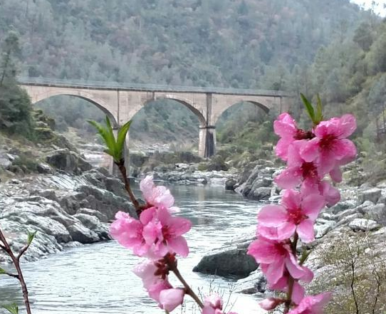
The rest of the WST is untouched by fire and is ready and waiting for your day hike. An easy 2-mile hike on the WST crosses the historic Mountain Quarries Railroad Bridge. The bridge was dubbed “No Hands” by an equestrian who crossed the bridge before rails were installed, with her hands in the air, declaring “Look, no hands!”
The river that runs beneath is refreshment to many park visitors all summer long, making this area very busy on weekends.
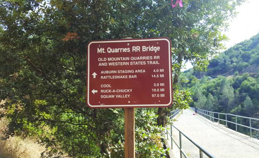
The easiest and arguably the most picturesque part has to be in the confluence area of the North Fork and Middle Fork of the American River, crossing the river near Highway 49.
This is an out and back trek that starts behind gate 150 in the Auburn State Recreation Area.
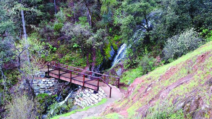
The destination is Canyon Creek and the wooden bridge that crosses it.
The waterfall that feeds the creek has been nicknamed the Black Hole of Calcutta. This nickname also came from an equestrian riding the end of the Tevis Cup in the dark of night.
But for locals who know the original story, this is just a more convenient location to send visitors, who ask to see the Black Hole of Calcutta, as the original, a mud puddle, is not much of a destination to take a selfie and share with friends.
The mostly level trail follows the river back to the Canyon Creek Bridge where the small falls are located.
Early mornings or late afternoons are best for me as most of the crowds have gone so it is easier to park near the trailhead.
I can never resist scrambling down to the river to do some rock hopping to the perfect perch to just watch the river roll by.
A historic site
The history of the bridge and trail is long and storied.
Auburn, the Endurance Capital of the World, welcomes the 61st annual Western States Trail Foundation Tevis Cup 100-Miles-One Day Trail Ride later this month on the heels of the 100 Mile Endurance Run, both starting in Squaw Valley and making its way to Auburn.
Both events are inspirational feats of physical and mental strength. Athletes come from all over the world for the privilege to run the WST and compete with the world’s best equestrians and trail runners in their respective events.
Still more come out for the training runs and fun rides just for the chance to experience parts of this historic path.
Prepare and how to get there
Exposed areas of the trail will make you wish you had your sunscreen, hat and glasses.
Always take a bottle of water and I never leave home without a camera. Although not as thick, you can still find poison oak here, and ticks too.
There are few trails that make me feel at home more than this part of the WST. Get to this part of WST by taking Interstate 80 to Auburn. Take the Elm Avenue exit to Highway 49 toward Placerville.
Follow Highway 49 into the canyon. Take the right over the river toward Cool.
Just over the bridge on the El Dorado County side you will find gate 150. Park as close to the trailhead as you like, and get ready for a great day hike.
To see additional photos and read the original article in the Auburn Journal newspaper CLICK HERE.
Now I feel a need to report what I know. According to state park officials 1/2 to 3/4 of a mile of the historic trail is within the fire boundary from Ford’s Bar to Peachstone. It is unclear how the damage may affect the upcoming Tevis Cup Ride.
Reports are coming in daily now that roads are slowly reopening and Tevis trail crews can get a look.
Tevis is set for July 23. The route is somewhat flexible so we will keep a close eye on developments concerning the safety of the riders and their mounts.
Fire is not new to the Western States Trail. We lost the swinging bridge a few years ago in the American Fire.
The events will go on. Time will heal these wounds, and we will hike this trail.
Ready to hike
The rest of the WST is untouched by fire and is ready and waiting for your day hike. An easy 2-mile hike on the WST crosses the historic Mountain Quarries Railroad Bridge. The bridge was dubbed “No Hands” by an equestrian who crossed the bridge before rails were installed, with her hands in the air, declaring “Look, no hands!”
The river that runs beneath is refreshment to many park visitors all summer long, making this area very busy on weekends.
The easiest and arguably the most picturesque part has to be in the confluence area of the North Fork and Middle Fork of the American River, crossing the river near Highway 49.
This is an out and back trek that starts behind gate 150 in the Auburn State Recreation Area.
The destination is Canyon Creek and the wooden bridge that crosses it.
The waterfall that feeds the creek has been nicknamed the Black Hole of Calcutta. This nickname also came from an equestrian riding the end of the Tevis Cup in the dark of night.
But for locals who know the original story, this is just a more convenient location to send visitors, who ask to see the Black Hole of Calcutta, as the original, a mud puddle, is not much of a destination to take a selfie and share with friends.
The mostly level trail follows the river back to the Canyon Creek Bridge where the small falls are located.
Early mornings or late afternoons are best for me as most of the crowds have gone so it is easier to park near the trailhead.
I can never resist scrambling down to the river to do some rock hopping to the perfect perch to just watch the river roll by.
A historic site
The history of the bridge and trail is long and storied.
Auburn, the Endurance Capital of the World, welcomes the 61st annual Western States Trail Foundation Tevis Cup 100-Miles-One Day Trail Ride later this month on the heels of the 100 Mile Endurance Run, both starting in Squaw Valley and making its way to Auburn.
Both events are inspirational feats of physical and mental strength. Athletes come from all over the world for the privilege to run the WST and compete with the world’s best equestrians and trail runners in their respective events.
Still more come out for the training runs and fun rides just for the chance to experience parts of this historic path.
Prepare and how to get there
Exposed areas of the trail will make you wish you had your sunscreen, hat and glasses.
Always take a bottle of water and I never leave home without a camera. Although not as thick, you can still find poison oak here, and ticks too.
There are few trails that make me feel at home more than this part of the WST. Get to this part of WST by taking Interstate 80 to Auburn. Take the Elm Avenue exit to Highway 49 toward Placerville.
Follow Highway 49 into the canyon. Take the right over the river toward Cool.
Just over the bridge on the El Dorado County side you will find gate 150. Park as close to the trailhead as you like, and get ready for a great day hike.
To see additional photos and read the original article in the Auburn Journal newspaper CLICK HERE.
 RSS Feed