Clementine Trail is one of, if not the, most popular trails in the Auburn State Recreation Area.
Starting at gate No. 139, the journey from the confluence of the North and Middle Forks of the American River takes you along the warmer North Fork back to Clementine Dam. The $10 state park day-use fee is in effect.
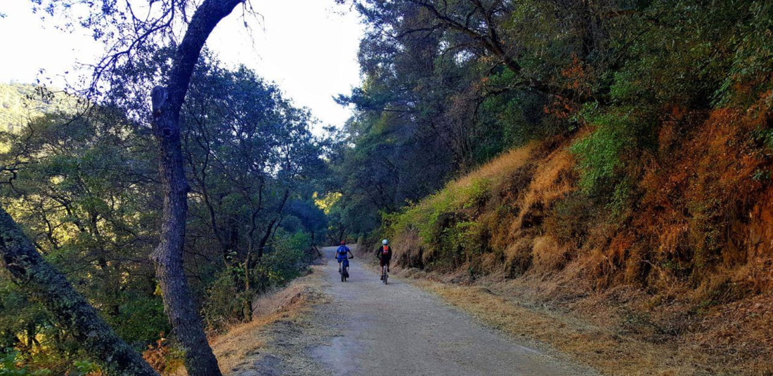
Photo credit: Mary West. Mountain bikes are allowed on part of the trail.
Along the way, old abutments from bridges, washed out years ago, still stand hugging the hillside. Above you is the Foresthill Bridge. The tallest bridge in California at 730 feet. The path starts low and wide then narrows with small climbs, always alongside the river. As much fun as this trail is in summer, I find it hot with many exposed areas. I wait till fall with fewer visitors and cooler temperatures.
Each year hikers manage to get lost here. I honestly don’t know how this happens; a poor sense of direction, dehydration, perhaps some other distraction. With the hillside on your right and the river on your left, on an out-and-back trail, one would think it manageable, but each summer the call goes out, rangers open the gates and drive in, even the CHP helicopter has been called to locate lost hikers. Almost like a Bermuda Triangle.
In under a mile you get to a wide spot on the river called Clark’s Hole. This is a very popular swimming hole in summer. Across the river is a great rock for sunbathing. Jumping from rocks is frowned upon by State Parks so I won’t mention how great a rock this is for that purpose. If Clark’s Hole is crowded, which it often is in the heat, just around the corner is Monkey Rock. This is a sweet spot with a jumble of rocks that make for great seating right at the water’s edge. This part of the trail is multi-use so horses, mountain bikes and dogs are allowed.
Continuing generally uphill, take note of the hillside on your right. In fall, you find water trickling, with ferns sprouting right out of the rock and thick moss enjoying this shaded side of the hill. At about the 1.9-mile mark, you find gate 140. You may have caught a sneak peek at the overflow of the dam through the trees by now, so another three-tenths of mile isn’t much. Go to the left and follow the paved road. Watch out for cars heading for the lake. Just before the dam you will see a trail marker off the road on the river side. Hike this and it leads you to a viewing area of the dam. State Parks wants you to stay off the dam itself but below the dam you can get a nice mist spray on a hot day, take pictures of the rainbow that usually forms there. After a good rain this area gets a little foamy and reminds me of the ocean. This is your half-way point. It is mostly downhill from here. There is no day use at the lake and swimming is not allowed on the lake. It is primarily a boat launch. Once you have placed yourself here on Facebook and uploaded your pictures to Instagram, had a snack and rested, it’s time for the return trip. I measure this trail at 3.8 miles round-trip. If you are prepared with plenty of water, good shoes and good company, you should be fine. Oh, and stay on the trail. It reduces the risk of getting lost.
Mary West is the author of the book series "Day Hiker: Gold Country Trail Guide." The books are a collection of Day Hiker columns (available on Amazon).
CLICK HERE to see the original article and Mary's photos in Gold Country Media.
Starting at gate No. 139, the journey from the confluence of the North and Middle Forks of the American River takes you along the warmer North Fork back to Clementine Dam. The $10 state park day-use fee is in effect.
Photo credit: Mary West. Mountain bikes are allowed on part of the trail.
Along the way, old abutments from bridges, washed out years ago, still stand hugging the hillside. Above you is the Foresthill Bridge. The tallest bridge in California at 730 feet. The path starts low and wide then narrows with small climbs, always alongside the river. As much fun as this trail is in summer, I find it hot with many exposed areas. I wait till fall with fewer visitors and cooler temperatures.
Each year hikers manage to get lost here. I honestly don’t know how this happens; a poor sense of direction, dehydration, perhaps some other distraction. With the hillside on your right and the river on your left, on an out-and-back trail, one would think it manageable, but each summer the call goes out, rangers open the gates and drive in, even the CHP helicopter has been called to locate lost hikers. Almost like a Bermuda Triangle.
In under a mile you get to a wide spot on the river called Clark’s Hole. This is a very popular swimming hole in summer. Across the river is a great rock for sunbathing. Jumping from rocks is frowned upon by State Parks so I won’t mention how great a rock this is for that purpose. If Clark’s Hole is crowded, which it often is in the heat, just around the corner is Monkey Rock. This is a sweet spot with a jumble of rocks that make for great seating right at the water’s edge. This part of the trail is multi-use so horses, mountain bikes and dogs are allowed.
Continuing generally uphill, take note of the hillside on your right. In fall, you find water trickling, with ferns sprouting right out of the rock and thick moss enjoying this shaded side of the hill. At about the 1.9-mile mark, you find gate 140. You may have caught a sneak peek at the overflow of the dam through the trees by now, so another three-tenths of mile isn’t much. Go to the left and follow the paved road. Watch out for cars heading for the lake. Just before the dam you will see a trail marker off the road on the river side. Hike this and it leads you to a viewing area of the dam. State Parks wants you to stay off the dam itself but below the dam you can get a nice mist spray on a hot day, take pictures of the rainbow that usually forms there. After a good rain this area gets a little foamy and reminds me of the ocean. This is your half-way point. It is mostly downhill from here. There is no day use at the lake and swimming is not allowed on the lake. It is primarily a boat launch. Once you have placed yourself here on Facebook and uploaded your pictures to Instagram, had a snack and rested, it’s time for the return trip. I measure this trail at 3.8 miles round-trip. If you are prepared with plenty of water, good shoes and good company, you should be fine. Oh, and stay on the trail. It reduces the risk of getting lost.
Mary West is the author of the book series "Day Hiker: Gold Country Trail Guide." The books are a collection of Day Hiker columns (available on Amazon).
CLICK HERE to see the original article and Mary's photos in Gold Country Media.
 RSS Feed