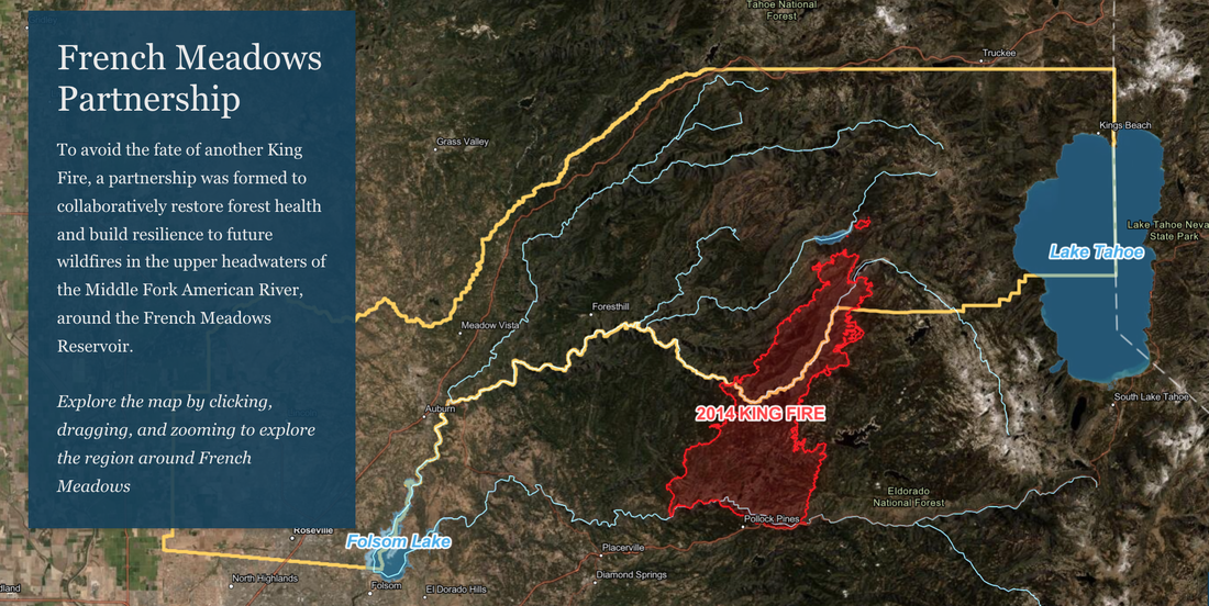
French Meadows Partnership
To avoid the fate of another King Fire, a partnership was formed to collaboratively restore forest health and build resilience to future wildfires in the upper headwaters of the Middle Fork American River, around the French Meadows Reservoir.
You can access this map on the webpage <- CLICK HERE.
Explore the map by clicking, dragging, and zooming to explore the region around French Meadows
The King FireThe catalyst of the French Meadows Forest Restoration Project was the 2014 King Fire, which burned over 97,000 acres in the American River watershed, much of it at high severity.
The fire impaired forest health, wildlife habitat, water quality, and hydroelectric assets by sending more than 300,000 tons of soil into the Rubicon River, a tributary of the Middle Fork American River.
These images of damage caused by the King Fire include a landslide area on the Rubicon River and the confluence of the Rubicon and Middle Fork American River. Notice the sediment in the water caused by the fire more than 30 miles upstream.
The French Meadows Forest Restoration Project, located just west of Lake Tahoe, covers more than 28,000 acres of public and private land in the Tahoe National Forest.
The partners who stepped up to collaborate together include the US Forest Service, Placer County, Placer County Water Agency, The Nature Conservancy, American River Conservancy, Sierra Nevada Conservancy, and Sierra Nevada Research Institute.
Together the partners developed a comprehensive restoration strategy for the headwaters of the Middle Fork of the American River that spans public lands managed by the Forest Service and private lands managed by the American River Conservancy.
Planning & ImplementationThe partners worked together to collaboratively plan the restoration effort across 28,000 acres that includes over 6,000 acres of ecologically-based thinning and 7,600 acres of prescribed fire on public land and another 1,600 acres of restoration on adjacent private land.
The French Meadows partnership embraces innovation and shared stewardship and together designed the restoration project to serve as a model for increasing the pace and scale of ecologically-based forest management and fuels reduction throughout the Sierra Nevada.
The planning and environmental compliance began in 2016 and took 18 months to complete. Implementation of the targeted ecological restoration work began in 2019; it will take five to seven years to complete the preliminary mechanical and hand-thinning to reduce fuels and prepare for reintroduction of fire as a restorative process...
To see the complete project, timelines, photos, maps, costs, benefits, visit the webpage:
https://storymaps.arcgis.com/stories/3cf1ddba68e34c59a5326e61e05d304b

 RSS Feed