As runoff gushes into Folsom and Shasta lakes, officials have increased flows down the American and Sacramento rivers, prompting safety warnings for those using the waterways for recreation.
As of 10 a.m. Thursday, the amount of water from Folsom Dam was at 70,000 cubic feet of water per second, according to the bureau. That’s the highest rate of water released this season, based on state data.
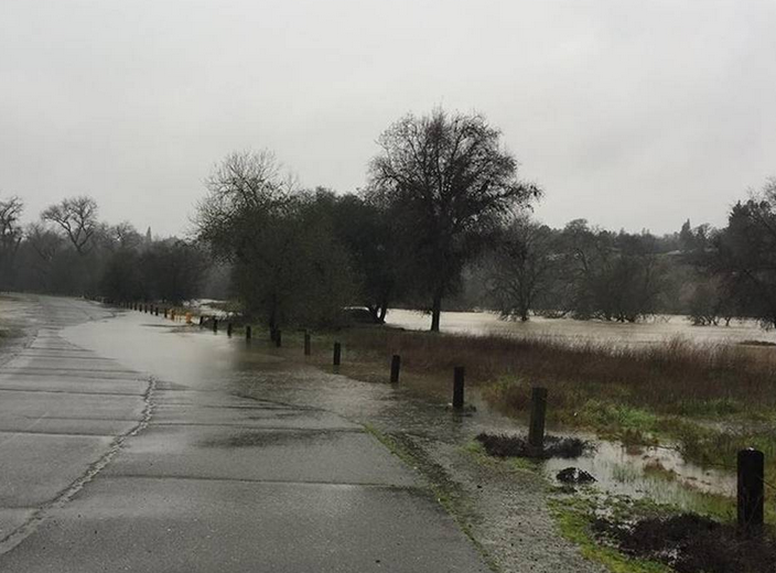
High river levels prompted the closure Thursday of all American River Parkway vehicle access points, according to county spokeswoman Kim Nava. Pedestrian access points will close Friday as well, and it remains to be seen when they will reopen.
“People recreating in or along the lower American River downstream of Folsom Dam to the confluence of the American and Sacramento rivers can expect river levels to increase and should take appropriate safety precautions,” the U.S. Bureau of Reclamation said in a news release.
In about two days, Folsom lake level has climbed 230,000 acre feet. Folsom Lake, with a capacity of 977,000 acre feet, was around 696,000 acre feet Thursday morning.
A strong storm on Thursday was expected to drop an inch or two of rain in Sacramento and perhaps four inches in the foothills. The warm nature of the storm has resulted in heavy runoff from the Sierra.
While 70,000 cfs was going out of Folsom Lake on Thursday, 114,000 was flowing into the reservoir.
The American River is expected to reach depths of 37.6 feet at the H Street Bridge – the highest it has been since the floods of 1997. It will remain about four feet below flood stage.
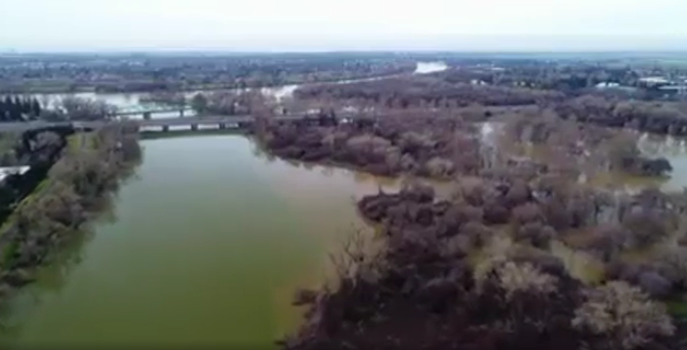
Several access points along the swollen American River are closed. Discovery Park is flooded.
Water releases are also increasing on the Sacramento River. The bureau said water from Shasta Lake into the Sacramento River would go up incrementally through the weekend.
Releases are expected to reach 50,000 cfs on Friday, 60,000 cfs on Saturday and 70,000 cfs on Sunday. The releases are needed to meet flood space regulations in Shasta Lake.
Shasta Lake is 10 miles north of Redding. Those downriver should prepare for increased flows.
Due to increased releases, the Sacramento River will rise even higher than it did following storms last month. It is expected to reach depths Thursday at Tower Bridge of 30.4 feet – the same depth as in the floods of 1997, state and federal figures show. The river will still be about three feet below flood stage at the Tower Bridge.
Lake Oroville added about 200,000 acre-feet of water in the 24 hours before 11 a.m. Thursday. The lake sat about 20 feet below the level where it reaches an emergency spillway at 11 a.m., and it was gaining about a foot of depth every two hours, state figures show.
Meanwhile, close to Sacramento, gates on the Sacramento Weir were reopened at 11 p.m. Wednesday. As of 11:06 a.m. Thursday, 25 gates were opened, according to the California Department of Water Resources.
The Sacramento Weir is the only manually operated weir on the Sacramento River system.
The 1,920-foot-long Sacramento Weir consists of 48 gates that must be opened with a long hooked pole. After a deluge of heavy rains, crews on Jan. 10 lifted the gates on the flood release structure near downtown Sacramento. It was the first time since 2006 that the river rose high enough to open the structure.
The weir gates were then closed after the area dried out some, before reopening again with the oncoming storm expected Thursday.
The weir acts as a flood-release valve to flush excess water from the Sacramento River system into the Yolo Bypass floodplain, keeping Sacramento and towns along the river from getting swamped.
CLICK HERE to read complete story and see video and photos in the Sacramento Bee newspaper.
As of 10 a.m. Thursday, the amount of water from Folsom Dam was at 70,000 cubic feet of water per second, according to the bureau. That’s the highest rate of water released this season, based on state data.
High river levels prompted the closure Thursday of all American River Parkway vehicle access points, according to county spokeswoman Kim Nava. Pedestrian access points will close Friday as well, and it remains to be seen when they will reopen.
“People recreating in or along the lower American River downstream of Folsom Dam to the confluence of the American and Sacramento rivers can expect river levels to increase and should take appropriate safety precautions,” the U.S. Bureau of Reclamation said in a news release.
In about two days, Folsom lake level has climbed 230,000 acre feet. Folsom Lake, with a capacity of 977,000 acre feet, was around 696,000 acre feet Thursday morning.
A strong storm on Thursday was expected to drop an inch or two of rain in Sacramento and perhaps four inches in the foothills. The warm nature of the storm has resulted in heavy runoff from the Sierra.
While 70,000 cfs was going out of Folsom Lake on Thursday, 114,000 was flowing into the reservoir.
The American River is expected to reach depths of 37.6 feet at the H Street Bridge – the highest it has been since the floods of 1997. It will remain about four feet below flood stage.
Several access points along the swollen American River are closed. Discovery Park is flooded.
Water releases are also increasing on the Sacramento River. The bureau said water from Shasta Lake into the Sacramento River would go up incrementally through the weekend.
Releases are expected to reach 50,000 cfs on Friday, 60,000 cfs on Saturday and 70,000 cfs on Sunday. The releases are needed to meet flood space regulations in Shasta Lake.
Shasta Lake is 10 miles north of Redding. Those downriver should prepare for increased flows.
Due to increased releases, the Sacramento River will rise even higher than it did following storms last month. It is expected to reach depths Thursday at Tower Bridge of 30.4 feet – the same depth as in the floods of 1997, state and federal figures show. The river will still be about three feet below flood stage at the Tower Bridge.
Lake Oroville added about 200,000 acre-feet of water in the 24 hours before 11 a.m. Thursday. The lake sat about 20 feet below the level where it reaches an emergency spillway at 11 a.m., and it was gaining about a foot of depth every two hours, state figures show.
Meanwhile, close to Sacramento, gates on the Sacramento Weir were reopened at 11 p.m. Wednesday. As of 11:06 a.m. Thursday, 25 gates were opened, according to the California Department of Water Resources.
The Sacramento Weir is the only manually operated weir on the Sacramento River system.
The 1,920-foot-long Sacramento Weir consists of 48 gates that must be opened with a long hooked pole. After a deluge of heavy rains, crews on Jan. 10 lifted the gates on the flood release structure near downtown Sacramento. It was the first time since 2006 that the river rose high enough to open the structure.
The weir gates were then closed after the area dried out some, before reopening again with the oncoming storm expected Thursday.
The weir acts as a flood-release valve to flush excess water from the Sacramento River system into the Yolo Bypass floodplain, keeping Sacramento and towns along the river from getting swamped.
CLICK HERE to read complete story and see video and photos in the Sacramento Bee newspaper.
 RSS Feed